Cram, George Franklin; Grant, A.A. Covers: Railroad And County Map Of Kansa... 1885 3989.001 Related Author
[Cram, George Franklin, Grant, A.A.]
Full Title
(Covers to) Railroad And County Map Of Kansas. Geo. F. Cram, Engraver and Publisher, Chicago.
List No
3989.001
Note
Map is folded into blue paper covers 15x9.5 with "Grant's Township And Rail Road Map Of Kansas. Published By A.A. Grant, No. 300 Broadway, New York." printed in black. On the back cover: "This Pocket Map Is printed from one of the plates of Grant's Railroad and Business Atlas." The map has Cram's imprint and also appeared in Cram's Standard American Atlas of The United States and Cram's Standard American Atlas of the World. With 27 page Index to Cram's Map of Kansas, and several pages of testimonials for Cram's Atlases. Printed color.
Author
[Cram, George Franklin, Grant, A.A.]
Full Title
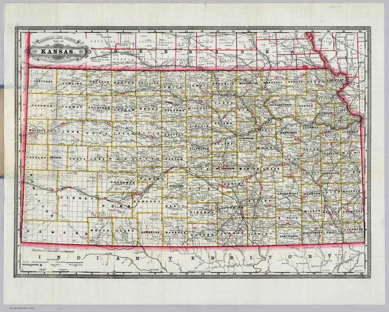
Railroad And County Map Of Kansas. Geo. F. Cram, Engraver and Publisher, Chicago.
List No
3989.002
Note
Map is folded into blue paper covers 15x9.5 with "Grant's Township And Rail Road Map Of Kansas. Published By A.A. Grant, No. 300 Broadway, New York." printed in black. On the back cover: "This Pocket Map Is printed from one of the plates of Grant's Railroad and Business Atlas." The map has Cram's imprint and also appeared in Cram's Standard American Atlas of The United States and Cram's Standard American Atlas of the World. With 27 page Index to Cram's Map of Kansas, and several pages of testimonials for Cram's Atlases. Printed color. Prime meridians are Greenwich and Washington D.C.
Cram, George Franklin; Grant, A.A. Covers: Railroad And County Map Of Monta... 1885 3990.001 Related Author
[Cram, George Franklin, Grant, A.A.]
Full Title
(Covers to) Railroad And County Map Of Montana Ty. Geo. F. Cram, Engraver and Publisher, Chicago. Copyright secured by Geo. F. Cram. Geo. H. Benedict, Sc.
List No
3990.001
Note
With four page Index to Cram's Map of Montana. Folded into blue paper covers 15x9.5 with "Grant's Township And Rail Road Map Of Montana Ter. Published By A.A. Grant, No. 300 Broadway, New York." printed in black. On the back cover: "This Pocket Map Is printed from one of the plates of Grant's Railroad and Business Atlas." Printed color. The map has Cram's imprint and also appeared in Cram's Standard American Atlas of The United States and Cram's Standard American Atlas of the World. Prime meridian is Washington D.C.
Author
[Cram, George Franklin, Grant, A.A.]
Full Title
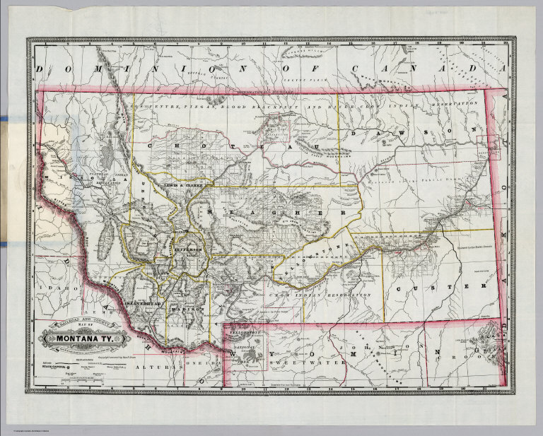
Railroad And County Map Of Montana Ty. Geo. F. Cram, Engraver and Publisher, Chicago. Copyright secured by Geo. F. Cram. Geo. H. Benedict, Sc.
List No
3990.002
Note
With four page Index to Cram's Map of Montana. Folded into blue paper covers 15x9.5 with "Grant's Township And Rail Road Map Of Montana Ter. Published By A.A. Grant, No. 300 Broadway, New York." printed in black. On the back cover: "This Pocket Map Is printed from one of the plates of Grant's Railroad and Business Atlas." Printed color. The map has Cram's imprint and also appeared in Cram's Standard American Atlas of The United States and Cram's Standard American Atlas of the World. Prime meridian is Washington D.C.
Author
Cram, George Franklin
Full Title
(Covers to) Railroad And County Map Of Texas. (inset map) Indian Ter. Geo. F. Cram, Engraver and Publisher, Chicago.
List No
4750.001
Note
With Cram's 29 page index. The same map appeared in Cram's Standard American Atlas of 1887. Printed color. Folded into blue paper covers 15x9.5 with "Cram's Township And Rail Road Map Of Texas. Published By George F. Cram, 262 & 264 Wabash Ave., Chicago." printed in black.
Author
Cram, George Franklin
Full Title
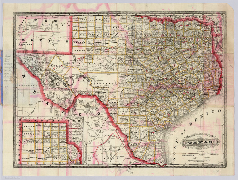
Railroad And County Map Of Texas. (inset map) Indian Ter. Geo. F. Cram, Engraver and Publisher, Chicago.
List No
4750.002
Note
With Cram's 29 page index. The same map appeared in Cram's Standard American Atlas of 1887. Printed color. Folded into blue paper covers 15x9.5 with "Cram's Township And Rail Road Map Of Texas. Published By George F. Cram, 262 & 264 Wabash Ave., Chicago." printed in black. Relief shown by hachures. Prime meridians are Greenwich and Washington D.C.
Author
Cram, George Franklin
Full Title
(Covers to) Railroad And County Map Of California. Geo. F. Cram, Engraver and Publisher, Chicago. 1890. (inset: untitled map of the San Francisco Bay Area by county).
List No
4903.001
Note
The map is from the Standard American Atlas; shows 22 railroads. Printed color. Folded into periwinkle blue paper covers 15x10 with "Cram's Township And Rail Road Map Of California. Published By George F. Cram, 415-417 Dearborn Street, Chicago." printed in black. With 17 page Index to State Map of California. Prime meridians are Greenwich and Washington D.C.
Author
Cram, George Franklin
Full Title
Railroad And County Map Of California. Geo. F. Cram, Engraver and Publisher, Chicago. 1890. (inset: untitled map of the San Francisco Bay Area by county).
List No
4903.002
Note
The map is from the Standard American Atlas; shows 22 railroads. Printed color. Folded into periwinkle blue paper covers 15x10 with "Cram's Township And Rail Road Map Of California. Published By George F. Cram, 415-417 Dearborn Street, Chicago." printed in black. With 17 page Index to State Map of California. Prime meridians are Greenwich and Washington D.C.
Author
Cram, George Franklin
Full Title
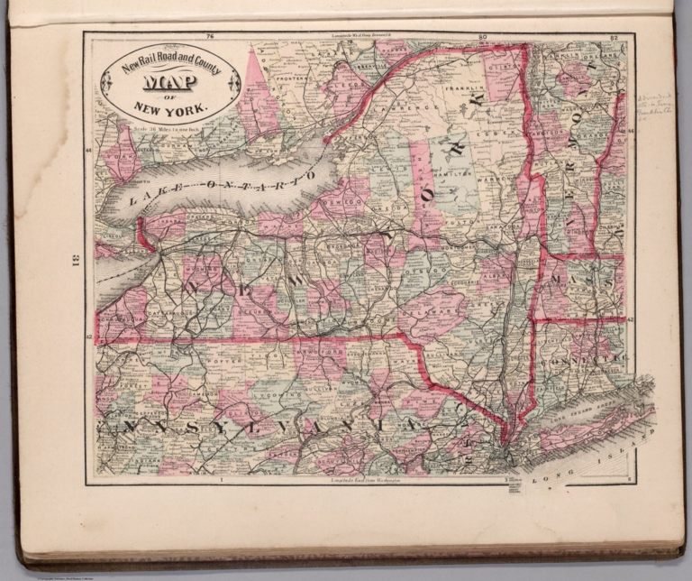
New Rail Road and County Map of New York.
List No
4558.026
Author
Cram, George Franklin
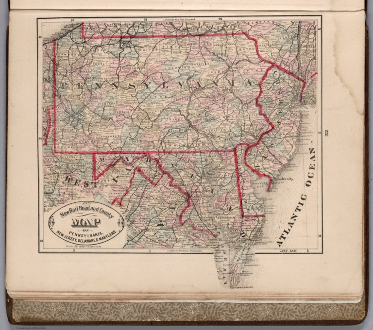
Full Title
New Rail Road and County Map of Pennsylvania, New Jersey, Delaware & Maryland.
List No
4558.027
Author
Cram, George Franklin
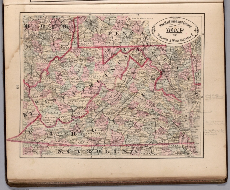
Full Title
New Rail Road and County Map of Virginia & West Virginia.E
List No
4558.028
Author
Cram, George Franklin
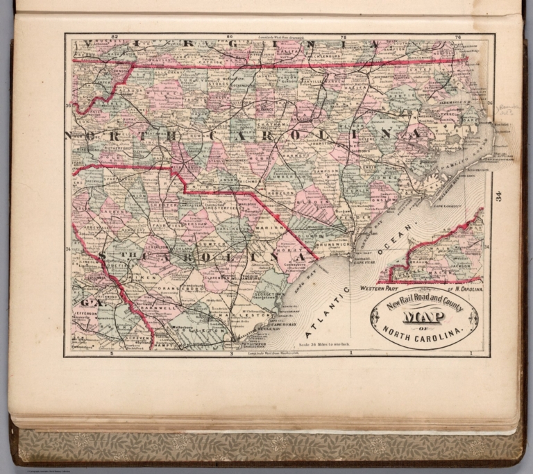
Full Title
New Rail Road and County Map of North Carolina.
List No
4558.029
Author
Cram, George Franklin
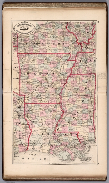
Full Title
New Rail Road and County Map of Arkansas, Louisiana, & Mississippi.
List No
4558.034
Author
Cram, George Franklin
Full Title
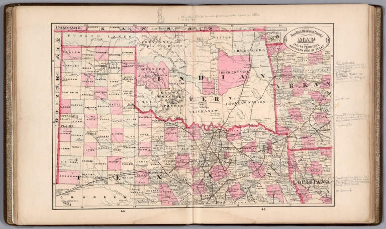
New Rail Road and County Map of Indian Territory and Northern Part of Texas.
List No
4558.036
Author
Cram, George Franklin
Full Title
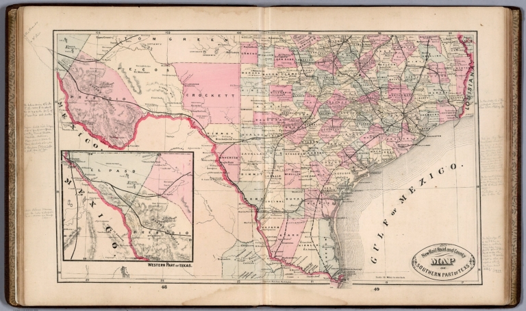
New Rail Road and County Map of Southern Part of Texas.
List No
4558.037
Author
Cram, George Franklin
Full Title
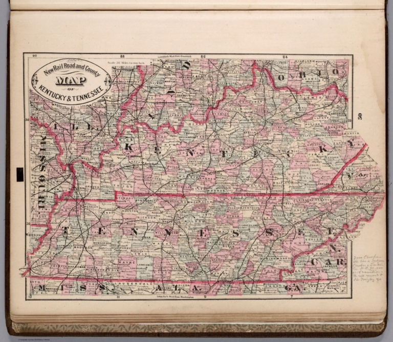
New Rail Road and County Map of Kentucky & Tennessee.
List No
4558.038
Author
Cram, George Franklin
Full Title
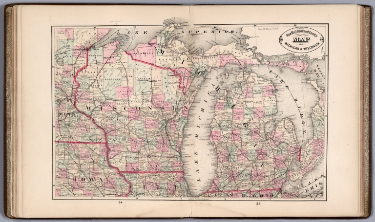
New Rail Road and County Map of Michigan & Wisconsin.
List No
4558.041
Author
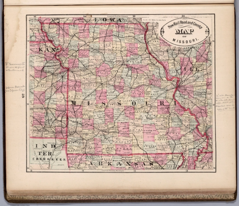
Cram, George Franklin
Full Title
New Rail Road and County Map of Missouri.
List No
4558.044
Author
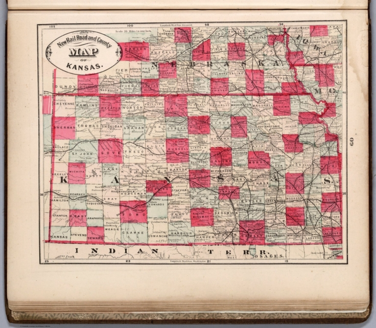
Cram, George Franklin
Full Title
New Rail Road and County Map of Kansas.
List No
4558.045
Author
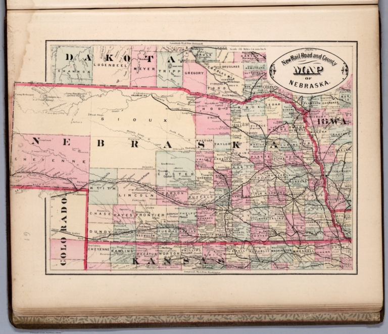
Cram, George Franklin
Full Title
New Rail Road and County Map of Nebraska.
List No
4558.046
Author
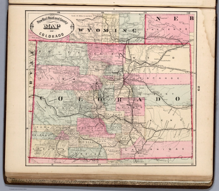
Cram, George Franklin
Full Title
New Rail Road and County Map of Colorado.
List No
4558.047
Author
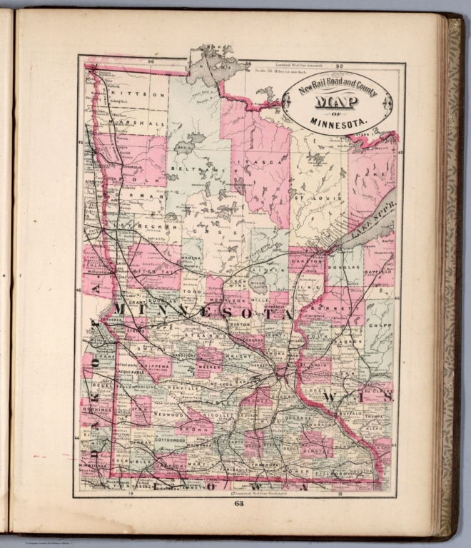
Cram, George Franklin
Full Title
New Rail Road and County Map of Minnesota.
List No
4558.048
Author
Cram, George Franklin
Full Title
New Rail Road and County Map of Dakota and Manitoba.
List No
4558.049
Author
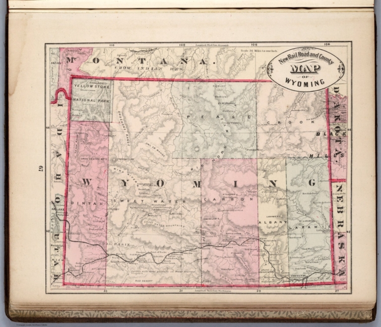
Cram, George Franklin
Full Title
New Rail Road and County Map of Wyoming.
List No
4558.050
Author
Cram, George Franklin
Full Title
New Rail Road and County Map of Montana and Northern Idaho.
List No
4558.051
Author
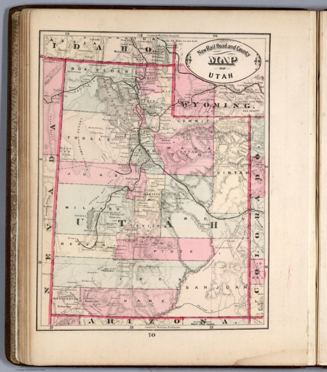
Cram, George Franklin
Full Title
New Rail Road and County Map of Utah.
List No
4558.052
Author
Cram, George Franklin
Full Title
New Rail Road and County Map of Southern Part of Idaho.
List No
4558.053
Author
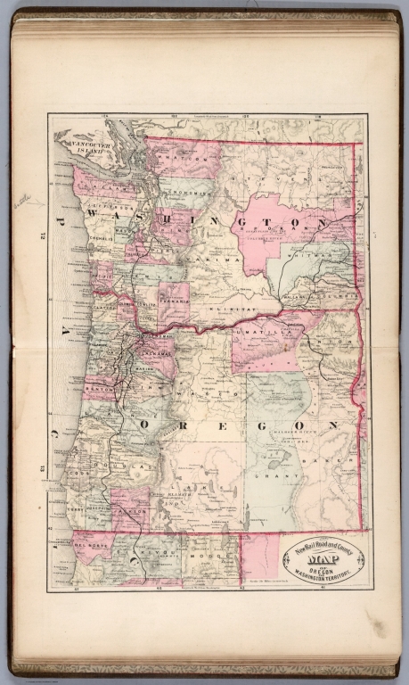
Cram, George Franklin
Full Title
New Rail Road and County Map of Oregon and Washington Territory.
List No
4558.054
Author
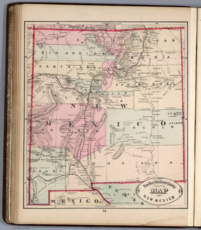
Cram, George Franklin
Full Title
New Rail Road and County Map of New Mexico.
List No
4558.055
Author
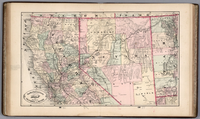
Cram, George Franklin
Full Title
New Rail Road and County Map of Northern California and Nevada.
List No
4558.056
Author
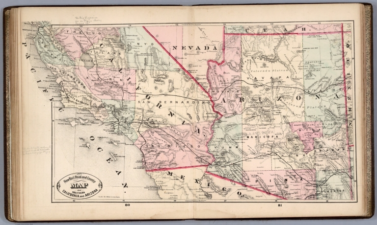
Cram, George Franklin
Full Title
New Rail Road and County Map of Southern California and Arizona.
List No
4558.058
Author
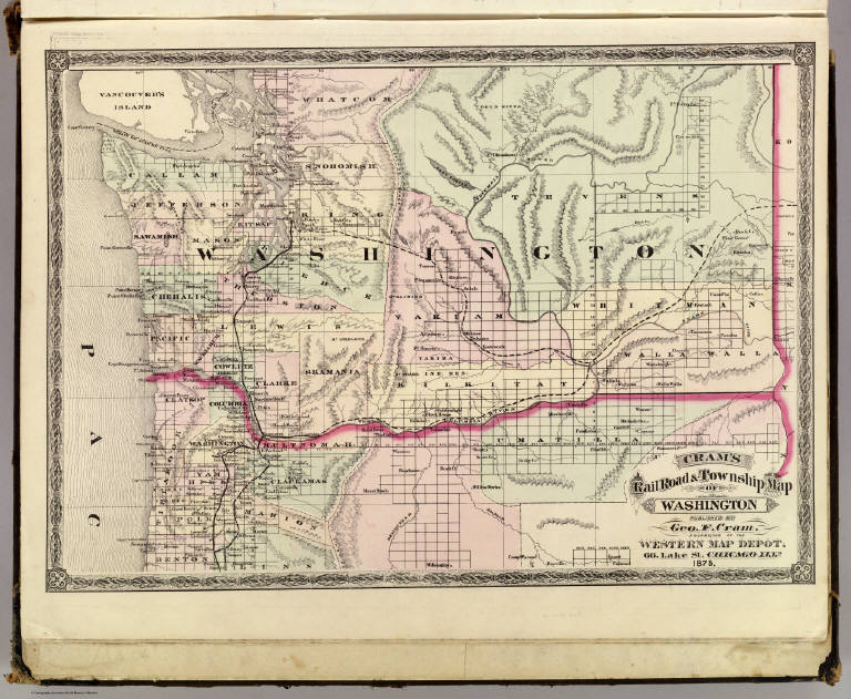
Cram, George Franklin
Full Title
Cram's Rail Road & Township Map of Washington. Published by Geo. F. Cram. Proprietor of the Western Map Depot. 66, Lake St. Chicago Ills. 1875.
List No
5370.034
Note
Map in full color by county. Railroad lines clearly shown. (Note: The map has been rotated 90 degrees clockwise for readability.)
Author
Cram, George Franklin
Full Title
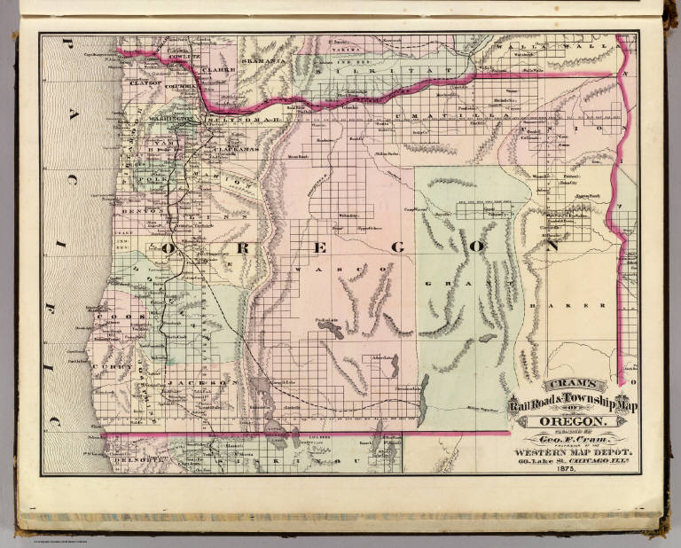
Cram's Rail Road & Township Map of Oregon. Published by Geo. F. Cram. Proprietor of the Western Map Depot. 66, Lake St. Chicago Ills. 1875.
List No
5370.035
Note
Map in full color by county. Railroad lines clearly shown. (Note: The map has been rotated 90 degrees counterclockwise for readability.)
Author
Cram, George Franklin
Full Title
Cram's Rail Road & Township Map of Indiana. Published by Geo. F. Cram. Proprietor of the Western Map Depot. 66, Lake St. Chicago Ills. 1875.
List No
5370.012
Note
Map in full color by county. The railroad lines are clearly marked.
Author
Cram, George Franklin
Full Title
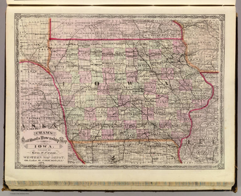
Cram's Rail Road & Township Map of Iowa. Published by Geo. F. Cram. Proprietor of the Western Map Depot. 66, Lake St. Chicago Ills. 1875.
List No
5370.013
Note
Map in full color by county. The railroad lines are clearly marked. (Note: The map has been rotated 90 degrees clockwise for readability.)
Author
Cram, George Franklin
Full Title
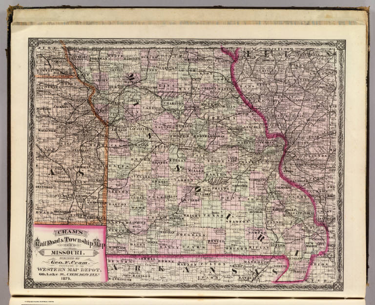
Cram's Rail Road & Township Map of Missouri. Published by Geo. F. Cram. Proprietor of the Western Map Depot. 66, Lake St. Chicago Ills. 1875.
List No
5370.014
Note
Map in full color by county. The railroad lines are clearly marked. (Note: The map has been rotated 90 degrees clockwise for readability.)
Author
Cram, George Franklin
Full Title
Cram's Rail Road & Township Map of Illinois. Published by Geo. F. Cram. Proprietor of the Western Map Depot. 66, Lake St. Chicago Ills. 1875.
List No
5370.015
Note
Map in full color by county. The railroad lines are clearly marked.
Author
Cram, George Franklin
Full Title
Cram's Rail Road & Township Map of Wisconsin. Published by Geo. F. Cram. Proprietor of the Western Map Depot. 66, Lake St. Chicago Ills. 1875.
List No
5370.016
Note
Map in full color by county. The railroad lines are clearly marked.
Author
Cram, George Franklin
Full Title
Cram's Rail Road & Township Map of Texas. Published by Geo. F. Cram. Proprietor of the Western Map Depot. 66, Lake St. Chicago Ills. 1875.
List No
5370.023
Note
Map in full color by county. Railroad lines clearly marked. (Note: The map has been rotated 90 degrees clockwise for readability.)
Author
Cram, George Franklin
Full Title
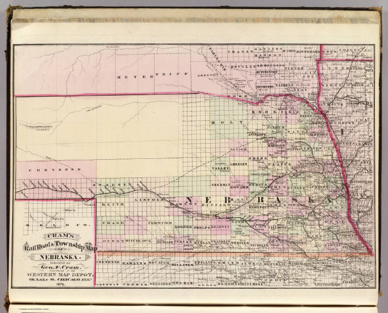
Cram's Rail Road & Township Map of Nebraska. Published by Geo. F. Cram. Proprietor of the Western Map Depot. 66, Lake St. Chicago Ills. 1875.
List No
5370.018
Note
Map in full color by county. The railroad lines are clearly marked. (Note: The map has been rotated 90 degrees clockwise for readability.)
Author
Cram, George Franklin
Full Title
Cram's Rail Road & Township Map of Minnesota. Published by Geo. F. Cram. Proprietor of the Western Map Depot. 66, Lake St. Chicago Ills. 1875.
List No
5370.019
Note
Map in full color by county. The railroad lines are clearly marked.
Author
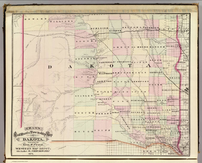
Cram, George Franklin
Full Title
Cram's Rail Road & Township Map of Dakota. Published by Geo. F. Cram. Proprietor of the Western Map Depot. 66, Lake St. Chicago Ills. 1875.
List No
5370.020
Note
Map in full color by county. The railroad lines are clearly marked. (Note: The map has been rotated 90 degrees clockwise for readability.)
Author
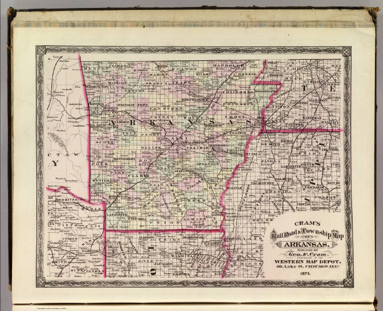
Cram, George Franklin
Full Title
Cram's Rail Road & Township Map of Arkansas. Published by Geo. F. Cram. Proprietor of the Western Map Depot. 66, Lake St. Chicago Ills. 1875.
List No
5370.021
Note
Map in full color by county. The railroad lines are clearly marked. (Note: The map has been rotated 90 degrees counterclockwise for readability.)
Author
Cram, George Franklin
Full Title
Cram's Rail Road & Township Map of Louisiana. Published by Geo. F. Cram. Proprietor of the Western Map Depot. 66, Lake St. Chicago Ills. 1875.
List No
5370.022
Note
Map in full color by county. The railroad lines are clearly marked.
Author
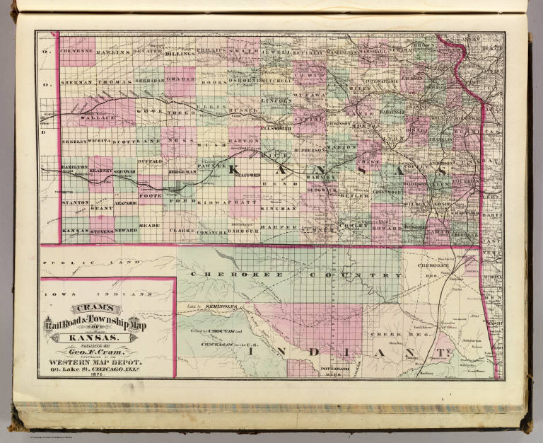
Cram, George Franklin
Full Title
Cram's Rail Road & Township Map of Kansas. Published by Geo. F. Cram. Proprietor of the Western Map Depot. 66, Lake St. Chicago Ills. 1875.
List No
5370.017
Note
Map in full color by county. The railroad lines are clearly marked. (Note: The map has been rotated 90 degrees clockwise for readability.)
Author
Cram, George Franklin
Full Title
(Covers to) Cram's Township & Rail Road Map Of The North Western States. Geo. F. Cram & Co. ... Proprietors Of The Western Map Depot. 148 Lake Street, Chicago Ills. 1870.
List No
0201.001
Note
1st edition was in 1869, with vignettes. Shows Iowa, Illinois, Wisconsin and Missouri with parts of Kansas, Nebraska and Minnesota. The upper and lower left corners have census data from 1870 and 1865. This is probably the only regional Cram pocket map. Full color. Folded into black cloth covers 14x9 with "New Rail-Road & Township Map Of North Western States Published By Geo. F. Cram & Co." in gilt.
Author
Cram, George Franklin
Full Title
Cram's Township & Rail Road Map Of The North Western States. Geo. F. Cram & Co. ... Proprietors Of The Western Map Depot. 148 Lake Street, Chicago Ills. 1870.
List No
0201.002
Note
1st edition was in 1869, with vignettes. Shows Iowa, Illinois, Wisconsin and Missouri with parts of Kansas, Nebraska and Minnesota. The upper and lower left corners have census data from 1870 and 1865. This is probably the only regional Cram pocket map. Full color. Folded into black cloth covers 14x9 with "New Rail-Road & Township Map Of North Western States Published By Geo. F. Cram & Co." in gilt.
Author
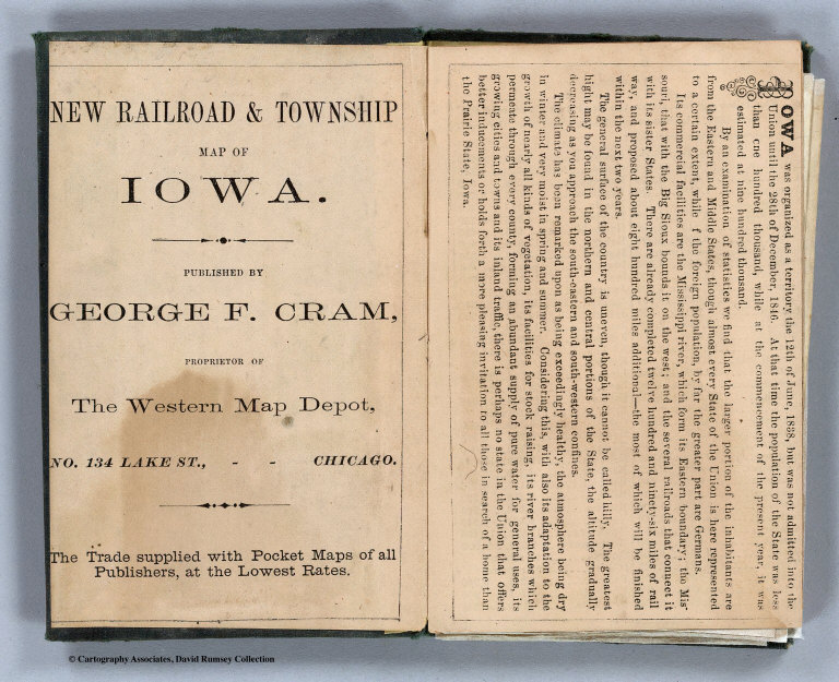
Cram, George Franklin
Full Title
(Covers to) New Rail Road And Township Map Of Iowa Engraved From Official Draughts of each County. Published By George F. Cram, Dealer In: Maps, Charts, Lithographic Pictures, Steel Engravings, Photographs &c. &c. 134 Lake St. Chicago, Ill. 1868. Entered ... 1868 by George F. Cram ... Illinois. Chas. Shober & Co. Lith. Chicago, Ill.
List No
3022.001
Note
1st edition, 1st year of operation for Cram's business. Everything about this map is different from Cram's later productions: it is his first year of operation, at 134 Lake Street, and the style of the cover, the map and the cartouche all have an "early" and unsophisticated look. Charles Shober is listed as Lithographer. Cram also produced the Guide Map to Chicago in 1868 (see our copy). Surviving pre fire maps by Cram are rare. Karrow shows 1869 maps for Missouri, Missouri and Kansas together, and Illinois, (all engraved by Pfeiffer, not Shober), but he shows no 1868 maps other than this Iowa and the Chicago maps. So this may be Cram's first state pocket map. It is copyright 1868. There is a view of a steam engine in the cartouche; this does not appear in later Cram maps. A 10 page index lists principal towns and counties, and gives a brief history of the state. Full color. Map is folded into stamped dark green cloth covers 14x9 with "New Township Map Of Iowa" in gilt.
Author
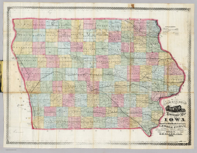
Cram, George Franklin
Full Title
(Title Page to) New Rail Road And Township Map Of Iowa Engraved From Official Draughts of each County. Published By George F. Cram, Dealer In: Maps, Charts, Lithographic Pictures, Steel Engravings, Photographs &c. &c. 134 Lake St. Chicago, Ill. 1868. Entered ... 1868 by George F. Cram ... Illinois. Chas. Shober & Co. Lith. Chicago, Ill.
List No
3022.002
Note
1st edition, 1st year of operation for Cram's business. Everything about this map is different from Cram's later productions: it is his first year of operation, at 134 Lake Street, and the style of the cover, the map and the cartouche all have an "early" and unsophisticated look. Charles Shober is listed as Lithographer. Cram also produced the Guide Map to Chicago in 1868 (see our copy). Surviving pre fire maps by Cram are rare. Karrow shows 1869 maps for Missouri, Missouri and Kansas together, and Illinois, (all engraved by Pfeiffer, not Shober), but he shows no 1868 maps other than this Iowa and the Chicago maps. So this may be Cram's first state pocket map. It is copyright 1868. There is a view of a steam engine in the cartouche; this does not appear in later Cram maps. A 10 page index lists principal towns and counties, and gives a brief history of the state. Full color. Map is folded into stamped dark green cloth covers 14x9 with "New Township Map Of Iowa" in gilt.
Author
Cram, George Franklin
Full Title
New Rail Road And Township Map Of Iowa Engraved From Official Draughts of each County. Published By George F. Cram, Dealer In: Maps, Charts, Lithographic Pictures, Steel Engravings, Photographs &c. &c. 134 Lake St. Chicago, Ill. 1868. Entered ... 1868 by George F. Cram ... Illinois. Chas. Shober & Co. Lith. Chicago, Ill.
List No
3022.003
Note
1st edition, 1st year of operation for Cram's business. Everything about this map is different from Cram's later productions: it is his first year of operation, at 134 Lake Street, and the style of the cover, the map and the cartouche all have an "early" and unsophisticated look. Charles Shober is listed as Lithographer. Cram also produced the Guide Map to Chicago in 1868 (see our copy). Surviving pre fire maps by Cram are rare. Karrow shows 1869 maps for Missouri, Missouri and Kansas together, and Illinois, (all engraved by Pfeiffer, not Shober), but he shows no 1868 maps other than this Iowa and the Chicago maps. So this may be Cram's first state pocket map. It is copyright 1868. There is a view of a steam engine in the cartouche; this does not appear in later Cram maps. A 10 page index lists principal towns and counties, and gives a brief history of the state. Full color. Map is folded into stamped dark green cloth covers 14x9 with "New Township Map Of Iowa" in gilt.
|