|
Author
Cram, George Franklin
Full Title
New Rail Road & township map of Missouri and Kansas : Published by Geo. F. Cram & Co. Western Map Depot. 148 Lake Street, Chicago Ills.
List No
7827.002
Note
Outline color regional map, with 3 vignettes. Folded into black cloth covers 14x9 with "New Rail-Road & Township Map Of Kansas and Missouri : Published By Geo. F. Cram & Co." in gilt. Identifies counties and clearly shows railroad lines.
Author
Cram, George Franklin
Full Title
(Covers to) Cram's Township & Rail Road Map Of The North Western States. Geo. F. Cram & Co. ... Proprietors Of The Western Map Depot. 148 Lake Street, Chicago Ills. 1870.
List No
0201.001
Note
1st edition was in 1869, with vignettes. Shows Iowa, Illinois, Wisconsin and Missouri with parts of Kansas, Nebraska and Minnesota. The upper and lower left corners have census data from 1870 and 1865. This is probably the only regional Cram pocket map. Full color. Folded into black cloth covers 14x9 with "New Rail-Road & Township Map Of North Western States Published By Geo. F. Cram & Co." in gilt.
Author
Cram, George Franklin
Full Title
Cram's Township & Rail Road Map Of The North Western States. Geo. F. Cram & Co. ... Proprietors Of The Western Map Depot. 148 Lake Street, Chicago Ills. 1870.
List No
0201.002
Note
1st edition was in 1869, with vignettes. Shows Iowa, Illinois, Wisconsin and Missouri with parts of Kansas, Nebraska and Minnesota. The upper and lower left corners have census data from 1870 and 1865. This is probably the only regional Cram pocket map. Full color. Folded into black cloth covers 14x9 with "New Rail-Road & Township Map Of North Western States Published By Geo. F. Cram & Co." in gilt.
Author
Cram, George Franklin
Full Title
(Covers to) Cram's Rail Road & Township Map Of Minnesota. Published By Geo. F. Cram. Proprietor Of The Western Map Depot. 66. Lake St. Chicago Ills. 1878. Entered ... 1878 by G.F. Cram ... Washington D.C.
List No
0204.001
Note
3rd edition with 12 page index & census. Full color. Folded into stamped black cloth covers 14x9 with "Indexed Railroad And Township Map Of Minnesota Published By Geo. F. Cram." in gilt.
Author
Cram, George Franklin
Full Title
Cram's Rail Road & Township Map Of Minnesota. Published By Geo. F. Cram. Proprietor Of The Western Map Depot. 66. Lake St. Chicago Ills. 1878. Entered ... 1878 by G.F. Cram ... Washington D.C.
List No
0204.002
Note
3rd edition with 12 page index & census. Full color. Folded into stamped black cloth covers 14x9 with "Indexed Railroad And Township Map Of Minnesota Published By Geo. F. Cram." in gilt.
Author
Cram, George Franklin
Full Title
(Covers to) Cram's Township And Rail Road Map Of The North West. Published By George F. Cram, Proprietor Of The Western Map Depot. 66 Lake St.: Chicago, Ills. 1878. Entered ... 1878, by G.F. Cram ... Washington D.C.
List No
0206.001
Note
This is a later version of our 1870 map of similar title (see our #201), although an entirely new plate has been used, at slightly larger scale. The census data has been removed to show more of Dakota and Kansas. Not in Karrow. Full color. Folded into brown cloth covers 14x9 with "Sectional Railroad And Township Map Of The N.W. States Published By Geo. F. Cram." in gilt.
Author
Cram, George Franklin
Full Title
Cram's Township And Rail Road Map Of The North West. Published By George F. Cram, Proprietor Of The Western Map Depot. 66 Lake St.: Chicago, Ills. 1878. Entered ... 1878, by G.F. Cram ... Washington D.C.
List No
0206.002
Note
This is a later version of our 1870 map of similar title (see our #201), although an entirely new plate has been used, at slightly larger scale. The census data has been removed to show more of Dakota and Kansas. Not in Karrow. Full color. Folded into brown cloth covers 14x9 with "Sectional Railroad And Township Map Of The N.W. States Published By Geo. F. Cram." in gilt.
Author
Cram, George Franklin
Full Title
(Covers to) Cram's Rail Road & Township Map Of Wisconsin. Published By Geo. F. Cram. Proprietor Of The Western Map Depot. 66. Lake St. Chicago Ills. 1879. Entered ... 1878 by G.F. Cram ... Washington D.C.
List No
0207.001
Note
With 19 page index plus ads. Folded into stamped black cloth covers 14x9 with "Indexed Railroad And Township Map Of Wisconsin Published By Geo. F. Cram." in gilt. Full color.
Author
Cram, George Franklin
Full Title
Cram's Rail Road & Township Map Of Wisconsin. Published By Geo. F. Cram. Proprietor Of The Western Map Depot. 66. Lake St. Chicago Ills. 1879. Entered ... 1878 by G.F. Cram ... Washington D.C.
List No
0207.002
Note
With 19 page index plus ads. Folded into stamped black cloth covers 14x9 with "Indexed Railroad And Township Map Of Wisconsin Published By Geo. F. Cram." in gilt. Full color.
Author
Cram, George Franklin
Full Title
(Covers to) Cram's Railroad & County Map Of Virginia, W. Virginia, Maryland & Delaware. Published By Geo. F. Cram. Proprietor Of The Western Map Depot. 262-264 Wabash, Ave. Chicago, Ills. 1881. Entered ... 1878, by G.F. Cram... Washington D.C.
List No
0209.001
Note
From the New Commercial Atlas of the U.S. 1875. Folded into brown cloth covers 14x9 with "Indexed Railroad And County Map Virginia W. Va. Md. & Delaware Published By Geo. F. Cram. Chicago" in gilt. Full color. Relief shown by hachures.
Author
Cram, George Franklin
Full Title
Cram's Railroad & County Map Of Virginia, W. Virginia, Maryland & Delaware. Published By Geo. F. Cram. Proprietor Of The Western Map Depot. 262-264 Wabash, Ave. Chicago, Ills. 1881. Entered ... 1878, by G.F. Cram... Washington D.C.
List No
0209.002
Note
From the New Commercial Atlas of the U.S. 1875. Folded into brown cloth covers 14x9 with "Indexed Railroad And County Map Virginia W. Va. Md. & Delaware Published By Geo. F. Cram. Chicago" in gilt. Full color. Relief shown by hachures.
Author
Cram, George Franklin
Full Title
Railroad and County Map of New Jersey.
List No
0210.028
Note
Prime meridians Greenwich and Washington.
Author
Cram, George Franklin
Full Title
New Rail Road and County Map of Deleware (Delaware), Maryland, Virginia & West Virginia.
List No
0210.029
Note
Prime meridians Greenwich and Washington.
Author
Cram, George Franklin
Full Title
New Rail Road and Count Map of North Carolina.
List No
0210.030
Note
Prime meridians Greenwich and Washington.
Author
Cram, George Franklin
Full Title
New Rail Road and County Map of Alabama, Georgia, Sth. Carolina & Northern Florida.
List No
0210.031
Note
Prime meridians Greenwich and Washington.
Author
Cram, George Franklin
Full Title
New Rail Road and County Map of Kentucky & Tennessee.
List No
0210.032
Note
Prime meridians Greenwich and Washington.
Author
Cram, George Franklin
Full Title
New Rail Road and County Map of Missouri.
List No
0210.033
Note
Prime meridians Greenwich and Washington.
Author
Cram, George Franklin
Full Title
New Rail Road and County Map of Michigan & Wisconsin.
List No
0210.040
Note
Prime meridians Greenwich and Washington.
Full Title
Some substantial proofs of Seattle's enterprise and culture. (Published by Ellis A. Davis. Berkeley, Cal. Seattle. 1909)
List No
2134.011
Note
Four reproductions of photographs. Contents: Interior of the Armory, University of Washington -- Lewis Hall (Men's Dormitory), University of Washington -- Administration Building, University of Washington -- The Union Depot. By courtesy of Alaska-Yukon Magazine. "The University views published by courtesy of the University administration."
Full Title
Views illustrating Spokane's prosperity. (Published by Ellis A. Davis. Berkeley, Cal. Seattle. 1909)
List No
2134.024
Note
Four reproductions of photographs. Contents: The Railroad Depot -- The Monroe Street Bridge, looking north to the County Court House -- Spokane's famous high school building; cost $175,000 -- The Spokane City Hall. "Views published by courtesy of the Spokane Chamber of Commerce."
Full Title
Views in Eastern Washington. (Published by Ellis A. Davis. Berkeley, Cal. Seattle. 1909)
List No
2134.027
Note
Eight reproductions of photographs. Contents: The Inland Empire System's freight terminal at Spokane -- High School, Rosalia -- High School, Garfield -- Where plums always thrive -- From an "Opportunity" garden -- A typical farmstead -- The "Shoshone Flyer," Inland Empire System. "The illustrations ... by courtesy of the Inland Empire System."
Author
C.C. Pierce & Co.
Full Title
Oregon and the Pacific Northwest. (Published by Ellis A. Davis. Berkeley, Cal. Seattle. 1909)
List No
2134.030
Note
Four reproductions of photographs. Contents: The Oregon State Capitol, Salem. By courtesy of the Salem Chamber of Commerce -- Along the Columbia River, Northern Oregon -- Reminiscences of the Old Pioneer Days; stage coaching in an Oregon Valley / copyright 1904 by C.C. Pierce & Co. 2075 -- Driving the golden spike that united the Union Pacific and Southern Pacific railways. "Unless otherwise credited, by courtesy of the Pacific Coast Magazine, Portland."
Author
Cram, George Franklin
Full Title
(Covers to) Cram's Rail Road & Township Map Of Kansas. Published By Geo. F. Cram. Proprietor Of The Western Map Depot. 66 Lake St. Chicago Ills.
List No
2370.001
Note
From Cram's 1875/1878 railroad atlas. Full hand color. 16 page catalogue and Index. Folded into dark brown cloth covers 14x9 with "Indexed Railroad And Township Map Of Kansas Published By Geo. F. Cram." in gilt.
Author
Cram, George Franklin
Full Title
Cram's Rail Road & Township Map Of Kansas. Published By Geo. F. Cram. Proprietor Of The Western Map Depot. 66 Lake St. Chicago Ills.
List No
2370.002
Note
From Cram's 1875/1878 railroad atlas. Full hand color. 16 page catalogue and Index. Folded into dark brown cloth covers 14x9 with "Indexed Railroad And Township Map Of Kansas Published By Geo. F. Cram." in gilt.
Author
Cram, George Franklin
Full Title
(Covers to) Cram's Standard American Railway System Atlas Of The World. Accompanied with a Complete and Simple Index of the United States ... Maps Of The United States Are The Largest Scale And Clearest Print Of Any Atlas Maps Published. Foreign Maps Are Compiled Largely From Charts Of The Royal Geographical Society, And Are Geographically Correct. Published by George F. Cram, 61-63 Plymouth Place, Chicago, Ill. 130 Fulton Street, New York. 1901. (on verso) Copyright Secured By George F. Cram, 1901.
List No
2809.001
Note
Atlas is bound in dark blue cloth covers with "Cram's Standard American Railway System Atlas" stamped in gilt on the spine.
Author
Cram, George Franklin
Full Title
(Title Page to) Cram's Standard American Railway System Atlas Of The World. Accompanied with a Complete and Simple index of the United States ... Maps Of The United States Are The Largest Scale And Clearest Print Of Any Atlas Maps Published. Foreign Maps Are Compiled Largely From Charts Of The Royal Geographical Society, And Are Geographically Correct. Published by George F. Cram, 61-63 Plymouth Place, Chicago, Ill. 130 Fulton Street, New York. 1901. (on verso) Copyright Secured By George F. Cram, 1901.
List No
2809.002
Author
Cram, George Franklin
Full Title
(Table of Contents to) Cram's Standard American Railway System Atlas Of The World. Accompanied with a Complete and Simple index of the United States ... Maps Of The United States Are The Largest Scale And Clearest Print Of Any Atlas Maps Published. Foreign Maps Are Compiled Largely From Charts Of The Royal Geographical Society, And Are Geographically Correct. Published by George F. Cram, 61-63 Plymouth Place, Chicago, Ill. 130 Fulton Street, New York. 1901. (on verso) Copyright Secured By George F. Cram, 1901.
List No
2809.003
Note
Arranged by broad category and the alphabetically.
Author
Cram, George Franklin
Full Title
Maine.
List No
2809.004
Note
Locations of banking towns shown by red circles. Railroads are indicated by numbers and colors and patterns, and each railroad has the same number and color and pattern in every state through which it passes. All railroads on each map are in a list keyed to the map. Border of map has a table of contents for the atlas. Relief shown by hachures. Prime meridians Washington D.C. and Greenwich.
Author
Cram, George Franklin
Full Title
New Hampshire and Vermont.
List No
2809.005
Note
Locations of banking towns shown by red circles. Railroads are indicated by numbers and colors and patterns, and each railroad has the same number and color and pattern in every state through which it passes. All railroads on each map are in a list keyed to the map. Border of map has a table of contents for the atlas. Relief shown by hachures. Prime meridians Washington D.C. and Greenwich.
Author
Cram, George Franklin
Full Title
Commercial Railroad and County Map of Massachusetts and Rhode Island. (inset) (Boston and Vicinity).
List No
2809.006
Note
Locations of banking towns shown by red circles. Railroads are indicated by numbers and colors and patterns, and each railroad has the same number and color and pattern in every state through which it passes. All railroads on each map are in a list keyed to the map. Border of map has a table of contents for the atlas. Relief shown by hachures. Prime meridians Washington D.C. and Greenwich.
Author
Cram, George Franklin
Full Title
Connecticut.
List No
2809.007
Note
Locations of banking towns shown by red circles. Railroads are indicated by numbers and colors and patterns, and each railroad has the same number and color and pattern in every state through which it passes. All railroads on each map are in a list keyed to the map. Border of map has a table of contents for the atlas. Relief shown by hachures. Prime meridians Washington D.C. and Greenwich.
Author
Cram, George Franklin
Full Title
New York, Western Half. (inset) (Long Island).
List No
2809.008
Note
Locations of banking towns shown by red circles. Railroads are indicated by numbers and colors and patterns, and each railroad has the same number and color and pattern in every state through which it passes. All railroads on each map are in a list keyed to the map. Border of map has a table of contents for the atlas. Relief shown by hachures. Prime meridians Washington D.C. and Greenwich.
Author
Cram, George Franklin
Full Title
New York, Eastern Half.
List No
2809.009
Note
Locations of banking towns shown by red circles. Railroads are indicated by numbers and colors and patterns, and each railroad has the same number and color and pattern in every state through which it passes. All railroads on each map are in a list keyed to the map. Border of map has a table of contents for the atlas. Relief shown by hachures. Prime meridians Washington D.C. and Greenwich.
Author
Cram, George Franklin
Full Title
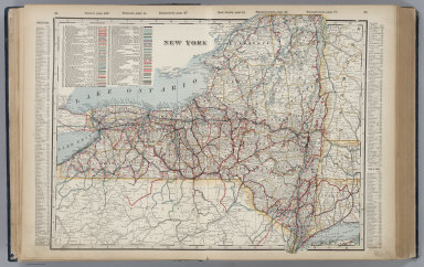
(Composite of) New York. (inset) (Long Island).
List No
2809.010
Note
Locations of banking towns shown by red circles. Railroads are indicated by numbers and colors and patterns, and each railroad has the same number and color and pattern in every state through which it passes. All railroads on each map are in a list keyed to the map. Border of map has a table of contents for the atlas. Relief shown by hachures. Prime meridians Washington D.C. and Greenwich.
Author
Cram, George Franklin
Full Title
New York.
List No
2809.011
Note
Locations of banking towns shown by red circles. Railroads are indicated by numbers and colors and patterns, and each railroad has the same number and color and pattern in every state through which it passes. All railroads on each map are in a list keyed to the map. Border of map has a table of contents for the atlas. Relief shown by hachures. Prime meridians Washington D.C. and Greenwich.
Author
Cram, George Franklin
Full Title
Western Half of Pennsylvania.
List No
2809.012
Note
Locations of banking towns shown by red circles. Railroads are indicated by numbers and colors and patterns, and each railroad has the same number and color and pattern in every state through which it passes. All railroads on each map are in a list keyed to the map. Border of map has a table of contents for the atlas. Relief shown by hachures. Prime meridians Washington D.C. and Greenwich.
Author
Cram, George Franklin
Full Title
Eastern Half of Pennsylvania.
List No
2809.013
Note
Locations of banking towns shown by red circles. Railroads are indicated by numbers and colors and patterns, and each railroad has the same number and color and pattern in every state through which it passes. All railroads on each map are in a list keyed to the map. Border of map has a table of contents for the atlas. Relief shown by hachures. Prime meridians Washington D.C. and Greenwich.
Author
Cram, George Franklin
Full Title
(Composite of) Pennsylvania.
List No
2809.014
Note
Locations of banking towns shown by red circles. Railroads are indicated by numbers and colors and patterns, and each railroad has the same number and color and pattern in every state through which it passes. All railroads on each map are in a list keyed to the map. Border of map has a table of contents for the atlas. Relief shown by hachures. Prime meridians Washington D.C. and Greenwich.
Author
Cram, George Franklin
Full Title
Pennsylvania. Copyright 1899, by Geo. F. Cram.
List No
2809.015
Note
Locations of banking towns shown by red circles. Railroads are indicated by numbers and colors and patterns, and each railroad has the same number and color and pattern in every state through which it passes. All railroads on each map are in a list keyed to the map. Border of map has a table of contents for the atlas. Relief shown by hachures. Prime meridians Washington D.C. and Greenwich.
Author
Cram, George Franklin
Full Title
New Jersey. Copyright, 1901, by Geo. F. Cram. (inset) Environs of Hudson County.
List No
2809.016
Note
Locations of banking towns shown by red circles. Railroads are indicated by numbers and colors and patterns, and each railroad has the same number and color and pattern in every state through which it passes. All railroads on each map are in a list keyed to the map. Border of map has a table of contents for the atlas. Relief shown by hachures. Prime meridians Washington D.C. and Greenwich.
Author
Cram, George Franklin
Full Title
Maryland and Delaware. (inset) Baltimore County.
List No
2809.017
Note
Locations of banking towns shown by red circles. Railroads are indicated by numbers and colors and patterns, and each railroad has the same number and color and pattern in every state through which it passes. All railroads on each map are in a list keyed to the map. Border of map has a table of contents for the atlas. Relief shown by hachures. Prime meridians Washington D.C. and Greenwich.
Author
Cram, George Franklin
Full Title
Western Half of Virginia and West Virginia.
List No
2809.018
Note
Locations of banking towns shown by red circles. Railroads are indicated by numbers and colors and patterns, and each railroad has the same number and color and pattern in every state through which it passes. All railroads on each map are in a list keyed to the map. Border of map has a table of contents for the atlas. Relief shown by hachures. Prime meridians Washington D.C. and Greenwich.
Author
Cram, George Franklin
Full Title
Eastern Half of Virginia and West Virginia.
List No
2809.019
Note
Locations of banking towns shown by red circles. Railroads are indicated by numbers and colors and patterns, and each railroad has the same number and color and pattern in every state through which it passes. All railroads on each map are in a list keyed to the map. Border of map has a table of contents for the atlas. Relief shown by hachures. Prime meridians Washington D.C. and Greenwich.
Author
Cram, George Franklin
Full Title
(Composite of) Virginia and West Virginia.
List No
2809.020
Note
Locations of banking towns shown by red circles. Railroads are indicated by numbers and colors and patterns, and each railroad has the same number and color and pattern in every state through which it passes. All railroads on each map are in a list keyed to the map. Border of map has a table of contents for the atlas. Relief shown by hachures. Prime meridians Washington D.C. and Greenwich.
Author
Cram, George Franklin
Full Title
Virginia and West Virginia.
List No
2809.021
Note
Locations of banking towns shown by red circles. Railroads are indicated by numbers and colors and patterns, and each railroad has the same number and color and pattern in every state through which it passes. All railroads on each map are in a list keyed to the map. Border of map has a table of contents for the atlas. Relief shown by hachures. Prime meridians Washington D.C. and Greenwich.
Author
Cram, George Franklin
Full Title
Ohio. (inset) Map of Hamilton County.
List No
2809.022
Note
This map trimmed such that some information is lost on upper and right margins. Locations of banking towns shown by red circles. Railroads are indicated by numbers and colors and patterns, and each railroad has the same number and color and pattern in every state through which it passes. All railroads on each map are in a list keyed to the map. Border of map has a table of contents for the atlas. Relief shown by hachures. Prime meridians Washington D.C. and Greenwich.
Author
Cram, George Franklin
Full Title
Michigan. (inset) Isle Royale.
List No
2809.023
Note
Locations of banking towns shown by red circles. Railroads are indicated by numbers and colors and patterns, and each railroad has the same number and color and pattern in every state through which it passes. All railroads on each map are in a list keyed to the map. Border of map has a table of contents for the atlas. Relief shown by hachures. Prime meridians Washington D.C. and Greenwich.
Author
Cram, George Franklin
Full Title
Indiana.
List No
2809.024
Note
Locations of banking towns shown by red circles. Railroads are indicated by numbers and colors and patterns, and each railroad has the same number and color and pattern in every state through which it passes. All railroads on each map are in a list keyed to the map. Border of map has a table of contents for the atlas. Relief shown by hachures. Prime meridians Washington D.C. and Greenwich.
Author
Cram, George Franklin
Full Title
Map of Illinois. George F. Cram, Publisher, 61-63 Plymouth Place, Chicago. (inset) Chicago and Vicinity.
List No
2809.025
Note
Locations of banking towns shown by red circles. Railroads are indicated by numbers and colors and patterns, and each railroad has the same number and color and pattern in every state through which it passes. All railroads on each map are in a list keyed to the map. Border of map has a table of contents for the atlas. Relief shown by hachures. Prime meridians Washington D.C. and Greenwich.
Author
Cram, George Franklin
Full Title
Iowa.
List No
2809.026
Note
Locations of banking towns shown by red circles. Railroads are indicated by numbers and colors and patterns, and each railroad has the same number and color and pattern in every state through which it passes. All railroads on each map are in a list keyed to the map. Border of map has a table of contents for the atlas. Relief shown by hachures. Prime meridians Washington D.C. and Greenwich.
Author
Cram, George Franklin
Full Title
Missouri. (inset) Vicinity of St. Louis.
List No
2809.027
Note
Locations of banking towns shown by red circles. Railroads are indicated by numbers and colors and patterns, and each railroad has the same number and color and pattern in every state through which it passes. All railroads on each map are in a list keyed to the map. Border of map has a table of contents for the atlas. Relief shown by hachures. Prime meridians Washington D.C. and Greenwich.
Author
Cram, George Franklin
Full Title
Kansas.
List No
2809.028
Note
Locations of banking towns shown by red circles. Railroads are indicated by numbers and colors and patterns, and each railroad has the same number and color and pattern in every state through which it passes. All railroads on each map are in a list keyed to the map. Border of map has a table of contents for the atlas. Relief shown by hachures. Prime meridians Washington D.C. and Greenwich.
Author
Cram, George Franklin
Full Title
Nebraska.
List No
2809.029
Note
Locations of banking towns shown by red circles. Railroads are indicated by numbers and colors and patterns, and each railroad has the same number and color and pattern in every state through which it passes. All railroads on each map are in a list keyed to the map. Border of map has a table of contents for the atlas. Relief shown by hachures. Prime meridians Washington D.C. and Greenwich.
Author
Cram, George Franklin
Full Title
Colorado.
List No
2809.030
Note
Locations of banking towns shown by red circles. Railroads are indicated by numbers and colors and patterns, and each railroad has the same number and color and pattern in every state through which it passes. All railroads on each map are in a list keyed to the map. Border of map has a table of contents for the atlas. Relief shown by hachures. Prime meridians Washington D.C. and Greenwich.
Author
Cram, George Franklin
Full Title
Wisconsin. (inset) Vicinity of Milwaukee.
List No
2809.031
Note
Locations of banking towns shown by red circles. Railroads are indicated by numbers and colors and patterns, and each railroad has the same number and color and pattern in every state through which it passes. All railroads on each map are in a list keyed to the map. Border of map has a table of contents for the atlas. Relief shown by hachures. Prime meridians Washington D.C. and Greenwich.
Author
Cram, George Franklin
Full Title
Minnesota. (inset) Environs of St. Paul and Minneapolis.
List No
2809.032
Note
Locations of banking towns shown by red circles. Railroads are indicated by numbers and colors and patterns, and each railroad has the same number and color and pattern in every state through which it passes. All railroads on each map are in a list keyed to the map. Border of map has a table of contents for the atlas. Relief shown by hachures. Prime meridians Washington D.C. and Greenwich.
Author
Cram, George Franklin
Full Title
North Dakota.
List No
2809.033
Note
Locations of banking towns shown by red circles. Railroads are indicated by numbers and colors and patterns, and each railroad has the same number and color and pattern in every state through which it passes. All railroads on each map are in a list keyed to the map. Border of map has a table of contents for the atlas. Relief shown by hachures. Prime meridians Washington D.C. and Greenwich.
Author
Cram, George Franklin
Full Title
South Dakota.
List No
2809.034
Note
Locations of banking towns shown by red circles. Railroads are indicated by numbers and colors and patterns, and each railroad has the same number and color and pattern in every state through which it passes. All railroads on each map are in a list keyed to the map. Border of map has a table of contents for the atlas. Relief shown by hachures. Prime meridians Washington D.C. and Greenwich.
Author
Cram, George Franklin
Full Title
Kentucky and Tennessee, Western Half.
List No
2809.035
Note
Locations of banking towns shown by red circles. Railroads are indicated by numbers and colors and patterns, and each railroad has the same number and color and pattern in every state through which it passes. All railroads on each map are in a list keyed to the map. Border of map has a table of contents for the atlas. Relief shown by hachures. Prime meridians Washington D.C. and Greenwich.
Author
Cram, George Franklin
Full Title
Kentucky and Tennessee, Eastern Half.
List No
2809.036
Note
Locations of banking towns shown by red circles. Railroads are indicated by numbers and colors and patterns, and each railroad has the same number and color and pattern in every state through which it passes. All railroads on each map are in a list keyed to the map. Border of map has a table of contents for the atlas. Relief shown by hachures. Prime meridians Washington D.C. and Greenwich.
Author
Cram, George Franklin
Full Title
(Composite of) Kentucky and Tennessee.
List No
2809.037
Note
Locations of banking towns shown by red circles. Railroads are indicated by numbers and colors and patterns, and each railroad has the same number and color and pattern in every state through which it passes. All railroads on each map are in a list keyed to the map. Border of map has a table of contents for the atlas. Relief shown by hachures. Prime meridians Washington D.C. and Greenwich.
Author
Cram, George Franklin
Full Title
Kentucky. Tennessee. (inset) Vicinity of Covington and Newport.
List No
2809.038
Note
Locations of banking towns shown by red circles. Railroads are indicated by numbers and colors and patterns, and each railroad has the same number and color and pattern in every state through which it passes. All railroads on each map are in a list keyed to the map. Border of map has a table of contents for the atlas. Relief shown by hachures. Prime meridians Washington D.C. and Greenwich.
Author
Cram, George Franklin
Full Title
Western Part of North and South Carolina.
List No
2809.039
Note
Locations of banking towns shown by red circles. Railroads are indicated by numbers and colors and patterns, and each railroad has the same number and color and pattern in every state through which it passes. All railroads on each map are in a list keyed to the map. Border of map has a table of contents for the atlas. Relief shown by hachures. Prime meridians Washington D.C. and Greenwich.
Author
Cram, George Franklin
Full Title
Eastern Part of North and South Carolina.
List No
2809.040
Note
Locations of banking towns shown by red circles. Railroads are indicated by numbers and colors and patterns, and each railroad has the same number and color and pattern in every state through which it passes. All railroads on each map are in a list keyed to the map. Border of map has a table of contents for the atlas. Relief shown by hachures. Prime meridians Washington D.C. and Greenwich.
Author
Cram, George Franklin
Full Title
(Composite of) North and South Carolina.
List No
2809.041
Note
Locations of banking towns shown by red circles. Railroads are indicated by numbers and colors and patterns, and each railroad has the same number and color and pattern in every state through which it passes. All railroads on each map are in a list keyed to the map. Border of map has a table of contents for the atlas. Relief shown by hachures. Prime meridians Washington D.C. and Greenwich.
Author
Cram, George Franklin
Full Title
North and South Carolina.
List No
2809.042
Note
Locations of banking towns shown by red circles. Railroads are indicated by numbers and colors and patterns, and each railroad has the same number and color and pattern in every state through which it passes. All railroads on each map are in a list keyed to the map. Border of map has a table of contents for the atlas. Relief shown by hachures. Prime meridians Washington D.C. and Greenwich.
Author
Cram, George Franklin
Full Title
Georgia.
List No
2809.043
Note
Locations of banking towns shown by red circles. Railroads are indicated by numbers and colors and patterns, and each railroad has the same number and color and pattern in every state through which it passes. All railroads on each map are in a list keyed to the map. Border of map has a table of contents for the atlas. Relief shown by hachures. Prime meridians Washington D.C. and Greenwich.
Author
Cram, George Franklin
Full Title
Florida. (inset) (extension of main map), North-Western Portion of Florida.
List No
2809.044
Note
Locations of banking towns shown by red circles. Railroads are indicated by numbers and colors and patterns, and each railroad has the same number and color and pattern in every state through which it passes. All railroads on each map are in a list keyed to the map. Border of map has a table of contents for the atlas. Relief shown by hachures. Prime meridians Washington D.C. and Greenwich.
Author
Cram, George Franklin
Full Title
Alabama.
List No
2809.045
Note
Locations of banking towns shown by red circles. Railroads are indicated by numbers and colors and patterns, and each railroad has the same number and color and pattern in every state through which it passes. All railroads on each map are in a list keyed to the map. Border of map has a table of contents for the atlas. Relief shown by hachures. Prime meridians Washington D.C. and Greenwich.
Author
Cram, George Franklin
Full Title
Mississippi.
List No
2809.046
Note
Locations of banking towns shown by red circles. Railroads are indicated by numbers and colors and patterns, and each railroad has the same number and color and pattern in every state through which it passes. All railroads on each map are in a list keyed to the map. Border of map has a table of contents for the atlas. Relief shown by hachures. Prime meridians Washington D.C. and Greenwich.
Author
Cram, George Franklin
Full Title
Louisiana.
List No
2809.047
Note
Locations of banking towns shown by red circles. Railroads are indicated by numbers and colors and patterns, and each railroad has the same number and color and pattern in every state through which it passes. All railroads on each map are in a list keyed to the map. Border of map has a table of contents for the atlas. Relief shown by hachures. Prime meridians Washington D.C. and Greenwich.
Author
Cram, George Franklin
Full Title
Arkansas.
List No
2809.048
Note
Locations of banking towns shown by red circles. Railroads are indicated by numbers and colors and patterns, and each railroad has the same number and color and pattern in every state through which it passes. All railroads on each map are in a list keyed to the map. Border of map has a table of contents for the atlas. Relief shown by hachures. Prime meridians Washington D.C. and Greenwich.
Author
Cram, George Franklin
Full Title
Western Half of Texas.
List No
2809.049
Note
Locations of banking towns shown by red circles. Railroads are indicated by numbers and colors and patterns, and each railroad has the same number and color and pattern in every state through which it passes. All railroads on each map are in a list keyed to the map. Border of map has a table of contents for the atlas. Relief shown by hachures. Prime meridians Washington D.C. and Greenwich.
Author
Cram, George Franklin
Full Title
Eastern Half of Texas.
List No
2809.050
Note
Locations of banking towns shown by red circles. Railroads are indicated by numbers and colors and patterns, and each railroad has the same number and color and pattern in every state through which it passes. All railroads on each map are in a list keyed to the map. Border of map has a table of contents for the atlas. Relief shown by hachures. Prime meridians Washington D.C. and Greenwich.
Author
Cram, George Franklin
Full Title
(Composite of) Texas.
List No
2809.051
Note
Locations of banking towns shown by red circles. Railroads are indicated by numbers and colors and patterns, and each railroad has the same number and color and pattern in every state through which it passes. All railroads on each map are in a list keyed to the map. Border of map has a table of contents for the atlas. Relief shown by hachures. Prime meridians Washington D.C. and Greenwich.
Author
Cram, George Franklin
Full Title
Texas. (inset) (Texas Panhandle).
List No
2809.052
Note
Locations of banking towns shown by red circles. Railroads are indicated by numbers and colors and patterns, and each railroad has the same number and color and pattern in every state through which it passes. All railroads on each map are in a list keyed to the map. Border of map has a table of contents for the atlas. Relief shown by hachures. Prime meridians Washington D.C. and Greenwich.
Author
Cram, George Franklin
Full Title
Oklahoma and Indian Terr.
List No
2809.053
Note
Locations of banking towns shown by red circles. Railroads are indicated by numbers and colors and patterns, and each railroad has the same number and color and pattern in every state through which it passes. All railroads on each map are in a list keyed to the map. Border of map has a table of contents for the atlas. Relief shown by hachures. Prime meridians Washington D.C. and Greenwich.
Author
Cram, George Franklin
Full Title
New Mexico.
List No
2809.054
Note
Locations of banking towns shown by red circles. Railroads are indicated by numbers and colors and patterns, and each railroad has the same number and color and pattern in every state through which it passes. All railroads on each map are in a list keyed to the map. Border of map has a table of contents for the atlas. Relief shown by hachures. Prime meridians Washington D.C. and Greenwich.
Author
Cram, George Franklin
Full Title
Arizona.
List No
2809.055
Note
Locations of banking towns shown by red circles. Railroads are indicated by numbers and colors and patterns, and each railroad has the same number and color and pattern in every state through which it passes. All railroads on each map are in a list keyed to the map. Border of map has a table of contents for the atlas. Relief shown by hachures. Prime meridians Washington D.C. and Greenwich.
Author
Cram, George Franklin
Full Title
Nevada.
List No
2809.056
Note
Locations of banking towns shown by red circles. Railroads are indicated by numbers and colors and patterns, and each railroad has the same number and color and pattern in every state through which it passes. All railroads on each map are in a list keyed to the map. Border of map has a table of contents for the atlas. Relief shown by hachures. Prime meridians Washington D.C. and Greenwich.
Author
Cram, George Franklin
Full Title
California and Nevada, Northern Half.
List No
2809.057
Note
Locations of banking towns shown by red circles. Railroads are indicated by numbers and colors and patterns, and each railroad has the same number and color and pattern in every state through which it passes. All railroads on each map are in a list keyed to the map. Border of map has a table of contents for the atlas. Relief shown by hachures. Prime meridians Washington D.C. and Greenwich.
Author
Cram, George Franklin
Full Title
California and Nevada, Southern Half.
List No
2809.058
Note
Locations of banking towns shown by red circles. Railroads are indicated by numbers and colors and patterns, and each railroad has the same number and color and pattern in every state through which it passes. All railroads on each map are in a list keyed to the map. Border of map has a table of contents for the atlas. Relief shown by hachures. Prime meridians Washington D.C. and Greenwich.
Author
Cram, George Franklin
Full Title
(Composite of) California and Nevada.
List No
2809.059
Note
Locations of banking towns shown by red circles. Railroads are indicated by numbers and colors and patterns, and each railroad has the same number and color and pattern in every state through which it passes. All railroads on each map are in a list keyed to the map. Border of map has a table of contents for the atlas. Relief shown by hachures. Prime meridians Washington D.C. and Greenwich.
Author
Cram, George Franklin
Full Title
California. (insets) Map of Section Surrounding San Francisco; Map of Hawaiian or Sandwich Islands.
List No
2809.060
Note
Locations of banking towns shown by red circles. Railroads are indicated by numbers and colors and patterns, and each railroad has the same number and color and pattern in every state through which it passes. All railroads on each map are in a list keyed to the map. Border of map has a table of contents for the atlas. Relief shown by hachures. Prime meridians Washington D.C. and Greenwich.
Author
Cram, George Franklin
Full Title
Montana.
List No
2809.061
Note
Locations of banking towns shown by red circles. Railroads are indicated by numbers and colors and patterns, and each railroad has the same number and color and pattern in every state through which it passes. All railroads on each map are in a list keyed to the map. Border of map has a table of contents for the atlas. Relief shown by hachures. Prime meridians Washington D.C. and Greenwich.
Author
Cram, George Franklin
Full Title
Utah.
List No
2809.062
Note
Locations of banking towns shown by red circles. Railroads are indicated by numbers and colors and patterns, and each railroad has the same number and color and pattern in every state through which it passes. All railroads on each map are in a list keyed to the map. Border of map has a table of contents for the atlas. Relief shown by hachures. Prime meridians Washington D.C. and Greenwich.
Author
Cram, George Franklin
Full Title
Wyoming.
List No
2809.063
Note
Locations of banking towns shown by red circles. Railroads are indicated by numbers and colors and patterns, and each railroad has the same number and color and pattern in every state through which it passes. All railroads on each map are in a list keyed to the map. Border of map has a table of contents for the atlas. Relief shown by hachures. Prime meridians Washington D.C. and Greenwich.
Author
Cram, George Franklin
Full Title
Yellowstone National Park, Wyoming.
List No
2809.064
Note
Locations of banking towns shown by red circles. Railroads are indicated by numbers and colors and patterns, and each railroad has the same number and color and pattern in every state through which it passes. All railroads on each map are in a list keyed to the map. Border of map has a table of contents for the atlas. Relief shown by hachures. Prime meridians Washington D.C. and Greenwich.
Author
Cram, George Franklin
Full Title
Idaho.
List No
2809.065
Note
Locations of banking towns shown by red circles. Railroads are indicated by numbers and colors and patterns, and each railroad has the same number and color and pattern in every state through which it passes. All railroads on each map are in a list keyed to the map. Border of map has a table of contents for the atlas. Relief shown by hachures. Prime meridians Washington D.C. and Greenwich.
Author
Cram, George Franklin
Full Title
Washington.
List No
2809.066
Note
Locations of banking towns shown by red circles. Railroads are indicated by numbers and colors and patterns, and each railroad has the same number and color and pattern in every state through which it passes. All railroads on each map are in a list keyed to the map. Border of map has a table of contents for the atlas. Relief shown by hachures. Prime meridians Washington D.C. and Greenwich.
Author
Cram, George Franklin
Full Title
Oregon.
List No
2809.067
Note
Top margin partially trimmed off. Locations of banking towns shown by red circles. Railroads are indicated by numbers and colors and patterns, and each railroad has the same number and color and pattern in every state through which it passes. All railroads on each map are in a list keyed to the map. Border of map has a table of contents for the atlas. Relief shown by hachures. Prime meridians Washington D.C. and Greenwich.
Author
Cram, George Franklin
Full Title
Alaska. (insets) Cook Inlet and Vicinity; Birch Creek and Tributaries; Klondike District.
List No
2809.068
Note
No counties shown. Relief shown by hachures. Prime meridians Washington D.C. and Greenwich.
Author
Cram, George Franklin
Full Title
Hawaii. Published by George F. Cram, Chicago, Ill. (inset) Honolulu.
List No
2809.069
Note
Relief shown by hachures.
Author
Cram, George Franklin
Full Title
Map of Porto Rico, Geo. F. Cram, Engraver and Publisher, Chicago, Ill. (insets) City and Harbor of San Juan; Crab Island and Culebra Isl.
List No
2809.070
Note
Relief shown by hachures. Prime meridians Washington D.C. and Greenwich.
Author
Cram, George Franklin
Full Title
Quebec.
List No
2809.071
Author
Cram, George Franklin
Full Title
Philippine Islands. (insets) Manila Province and Vicinity showing Seat of War; Lower Part of Mindanao (continuation of main map).
List No
2809.072
Note
Border of map has a table of contents for the atlas. Relief shown by hachures.
Author
Cram, George Franklin
Full Title
Montreal.
List No
2809.073
Author
Cram, George Franklin
Full Title
New Foundland and Labrador.
List No
2809.074
Note
Relief shown by hachures. Prime meridians Washington D.C. and Greenwich.
Author
Cram, George Franklin
Full Title
Western Half of Nova Scotia.
List No
2809.075
Note
Locations of banking towns shown by red circles. All railroads on each map are in a list keyed to the map. Border of map has a table of contents for the atlas. Relief shown by hachures. Prime meridians Washington D.C. and Greenwich.
Author
Cram, George Franklin
Full Title
Eastern Half of Nova Scotia.
List No
2809.076
Note
Locations of banking towns shown by red circles. Railroads are indicated by numbers. All railroads on each map are in a list keyed to the map. Border of map has a table of contents for the atlas. Relief shown by hachures. Prime meridians Washington D.C. and Greenwich.
|