|
REFINE
Browse All : Images by Colton, J. H.
1-115 of 115
Author
[Colton, J. H., Smith, J. Calvin]
Full Title
Colton's Township and Railroad Map Of The United States Of America Including a Large Portion of Canada, New Brunswick &c. Showing the Base Meridian and Township Lines of the U.S. Surveys. Rail Roads and other Internal Improvements. Compiled from surveys of the United States Land Office, and various other authentic sources. Published by J.H. Colton, 172 William St. New York. 1862. Entered ... 1843 by Geo. E. Sherman & J. Calvin Smith ... New York. Entered ... 1860 by J.H. Colton ... New York ... (inset) Map Of North America. (inset) Southern Part Of Florida.
List No
10277.000
Note
This is a late edition of the Colton/Smith map of the United States, first issued in 1843. Smith's name is removed and the title is modified to emphasize railroad development. No mention of the Civil War is made on the map even though the map was published during the fighting. There are many updates to the geography, showing new states and territories as well as railroads.
Author
[Burr, David H., 1803-1875, Colton, J. H.]
Full Title
(Covers to) United States. By David H. Burr. Published by J.H. Colton & Co. New York. 9 Wall Street. 1833. Engraved by S. Stiles & Co., N. York. Entered ... 1833, by J.H. Colton & Co. ... New York.
List No
0110A
Note
Dark teal leather covers 13.5x8 with "Burr's Map of the United States Published By J.H. Colton & Co. New York" and a decorative border stamped in gilt.
Author
[Burr, David H., 1803-1875, Colton, J. H.]
Full Title
United States. By David H. Burr. Published by J.H. Colton & Co. New York. 9 Wall Street. 1833. Engraved by S. Stiles & Co., N. York. Entered ... 1833, by J.H. Colton & Co. ... New York.
List No
0110.001
Note
This is the first year of Colton's map publishing business. Ristow says that Colton published his first map in 1833, Burr's map of New York State; this U.S. map must be as early. The graphic style is similar to Burr's Universal Atlas maps, engraved the following year. With six detailed and elegant inset maps showing the environs of Albany, Boston, New York, Cincinnati, Philadelphia, and Baltimore & Washington; plus a small inset map of South Part of Florida. Outline color, folded into dark teal leather covers 13.5x8 with "Burr's Map of the United States Published By J.H. Colton & Co. New York" and a decorative border stamped in gilt. Prime meridians: Greenwich and Washington.
Author
[Colton, G.W., Colton, J. H.]
Full Title
(Covers to) Map Of The Country Thirty Three Miles Around The City Of New York. Published By J.H. Colton, No. 86 Cedar St. New York, 1853. Entered ... 1846, by J.H. Colton ... New York. Drawn by G.W. Colton. Engraved by J.M. Atwood, N.Y.
List No
0173A
Author
[Colton, G.W., Colton, J. H.]
Full Title
Map Of The Country Thirty Three Miles Around The City Of New York. Published By J.H. Colton, No. 86 Cedar St. New York, 1853. Entered ... 1846, by J.H. Colton ... New York. Drawn by G.W. Colton. Engraved by J.M. Atwood, N.Y.
List No
0173.001
Note
With red cloth covers 14.5x9 stamped with gilt title reading "Thirty Three Miles Around The City Of New-York." and a small circular map of New York (later editions omit the map on the cover). First issued in 1846, when it was reengraved by Atwood from J.H. Eddy's "Map of the Country Thirty Miles round the City of New York" which was originally issued in 1811 (see our #3472). This is one of Colton's most attractive maps, showing New York and vicinity in circular format surrounded by a vine border with views of City Hall, New York and City Hall, Brooklyn. It was published in many editions for almost fifty years - our latest edition is 1891 (Haskell lists eight editions from 1846 to 1873 only). The early editions were engraved on copper plate (our 1853) and at some point before our 1865 edition the copper plate was transferred to lithographic stone and all subsequent editions were lithographed.
Author
Colton, J. H.
Full Title
Letter to Mr. G.C. Barclay from J.H. Colton dated February 26th, 1864 from New York.
List No
0185A
Note
Note concerning the use of his maps as advertisements. The letter is on company letterhead.
Author
[Colton, J. H., Norman, B.M., Persac, A.]
Full Title
Norman's Chart Of The Lower Mississippi River By A. Persac. Published by B.M. Norman, New Orleans, La. 1858. Entered ... 1858 by B.M. Norman ... Louisiana. Engraved, Printed & Mounted By J.H. Colton & Co. New York. (At top) From Natchez to New Orleans.
List No
2752.000
Note
Views; shows Plantations by type; very scarce. In full color; lacks original covers. See our reproduction copy issued by Pelican Press, originally in 1931, and printed by Rand McNally - this reproduction greatly alters the original. Ritzlin catalogue: "Persac was a well known surveyor and landscape painter... the map is quite scarce and normally in poor condition because most copies were used by river pilots to locate plantation landings. Few copies are known in contemporary boards. NUC lists only three copies ... however several copies are located in the south, including one which the Louisiana Supreme Court still uses in land ownership cases." Incredible detail, showing the Plantations on both sides of the river. Four engraved views. Engraved by J.H. Colton. Lacking boards, this copy has some tears at the folds with slight loss at some intersections, some light browning in two areas, but is overall a very good copy. Copies at LSU, Historic New Orleans Collection (504-523-4662). See Antiques Magazine, Nov. 1991 for Persac Article. Norman also published "Norman's New Orleans and Environs" with a map of the city, in 1845 (see our copy).
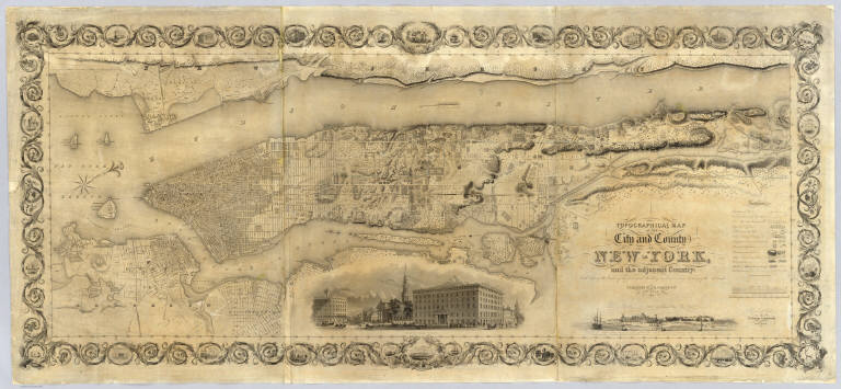
Author
Colton, J. H.
Full Title
Topographical Map Of The City and County Of New - York, and the adjacent Country: With Views in the border of the principal Buildings and interesting Scenery of the Island. Published By J.H. Colton & Co. No. 4 Spruce St. New-York. 1836. Engraved & Printed by S. Stiles & Company, New-York. Entered ... 1836, by J.H. Colton & Co. ... New York.
List No
2784.000
Note
1st ed., 2nd state. Stokes: "This is one of the most beautiful nineteenth century plans or maps of Manhattan Island, and is full of interesting information, It is perhaps the last example of really artistic map-making, as applied to Manhattan Island." Ristow believes that Burr may have drawn this map based on similarities between it and the Burr New York City map that appeared in Burr's New York State Atlas of 1829. Accompanied by the "Summary History.." Stokes describes his copy of the 1st edition as not listing Madison Square and some other differences between the 1836 and 1841 editions which would lead one to conclude that this copy is slightly later than 1836 (it shows Madison Square which was established in 1837) - apparently an unrecorded 2nd state of the first edition. Without color or top and bottom rollers.
Author
Colton, J. H.
Full Title
(Covers to) Maine. 1853. Published By J.H. Colton. No. 86 Cedar St. New York. Entered ... 1853, by J.H. Colton ... New York.
List No
3164A
Note
First edition, from the "Travelling Maps" series, with Census information on verso and unique border. The inside front cover has a label of "The Portland Map Depository... Brown & Hall, Gen'l Ag'ts." Full color, folded into stamped black cloth covers 13x9 with "Map Of Maine J.H. Colton" in gilt.
Author
Colton, J. H.
Full Title
Maine. 1853. Published By J.H. Colton. No. 86 Cedar St. New York. Entered ... 1853, by J.H. Colton ... New York.
List No
3164.001
Note
First edition, from the "Travelling Maps" series, with Census information on verso and unique border. The inside front cover has a label of "The Portland Map Depository... Brown & Hall, Gen'l Ag'ts." Full color, folded into stamped black cloth covers 13x9 with "Map Of Maine J.H. Colton" in gilt.
Author
[Colton, J. H., Creuzbaur, Robert, De Cordova, Jacob]
Full Title
(Covers to) J. De Cordova's Map Of The State Of Texas Compiled from the records of the General Land Office of the State by Robert Creuzbaur, Revised and Corrected by Charles W. Pressler. Published by J.H. Colton & Co. No. 172 William St. New York 1856. Engraved by J.M. Atwood, New York. Entered ... 1856 by J. De Cordova ... Texas. (with untitled inset of southwestern U.S.).
List No
3366A
Author
[Colton, J. H., Creuzbaur, Robert, De Cordova, Jacob]
Full Title
J. De Cordova's Map Of The State Of Texas Compiled from the records of the General Land Office of the State by Robert Creuzbaur, Revised and Corrected by Charles W. Pressler. Published by J.H. Colton & Co. No. 172 William St. New York 1856. Engraved by J.M. Atwood, New York. Entered ... 1856 by J. De Cordova ... Texas. (with untitled inset of southwestern U.S.).
List No
3366.001
Note
First edition of Pressler's revision of De Cordova's map, and first edition published by Colton. Shows Texas east of the 102nd meridian. First issued by De Cordova in 1849, with editions of 1850, 51, 53, 56, 57, 58, and 61 (Ristow and Rosenberg), and a late unlisted edition in 1867 (see our #4801). De Cordova employed Pressler to revise the map in 1855 and then sold the rights to Colton in the same year. The 1849 edition has only two copies located. Eberstadt called the 1849 issue "possibly the finest (Texas map) of the period." Colton changed the inset map from the oval showing all of Texas to the southwestern portion of Colton's U.S. atlas map. J.M. Atwood was the engraver of all editions. With a list of the Land districts, this map was useful for both land promoters and settlers. Colton published a reduced version of the map in his 1856 Atlas of the World. The full color map is folded into stamped dark maroon leather covers 16x10.5 with "J. De Cordova's Texas J.H. Colton & Co. New York." in gilt.
Author
Colton, J. H.
Full Title
(Covers to) Nebraska And Kansas. Published By J.H. Colton & Co. No. 172 William St. New York. Entered ... 1854 by J.H. Colton ... New York. (inset) Map Of The Territory acquired from Mexico by the Gadsden Treaty, 1854. (untitled inset of U.S., Mexico, Central America). Printed by D. Mc Lellan, 26 Spruce St. N.Y.
List No
3873A
Author
Colton, J. H.
Full Title
Nebraska And Kansas. Published By J.H. Colton & Co. No. 172 William St. New York. Entered ... 1854 by J.H. Colton ... New York. (inset) Map Of The Territory acquired from Mexico by the Gadsden Treaty, 1854. (untitled inset of U.S., Mexico, Central America). Printed by D. Mc Lellan, 26 Spruce St. N.Y.
List No
3873.001
Note
First edition, first state. First map to show the new Kansas and Nebraska; also shows the important Gadsden Purchase of the same year. This state precedes all other copies we have seen - it is an early pull from the late 1854, early 1855 Colton Map of the United States of America... wall map plate (see our #2834, indicating it appeared in middle or late 1854 - see our 1855 wall map copy #2278 for the corrected topography), with the title different from the second 1854 state, in that the letters of Nebraska and Kansas have stars in them and are open as opposed to the black letters of the second state. Also, this first state has numerous areas that are "cleaned up" in the second state: the trail that crosses the two forks of the Colorado in southern Utah near the map edge has the word "Route" on it - this is removed in the second state; the vine border is reversed from the first to the second state; Louisiana is written straight across in the first - it curves down in the second; Bucksport and San Augustine are shown in Texas along the map southern edge in the second state and not in the first; Sacket's Well and Laguna in California in the inset map are given dots for their location in the second state but not in the first. There are other changes. Streeter shows a second edition in 1855, Heaston a third edition in 1856, but both copyrighted 1855. These have various route changes and place names added when compared to the 1854. A fourth edition appeared in 1857 (see Karrow 12-0361.2 and Graff 836) with the inset of the U.S. changed to Eastern Nebraska and Kansas. Map is full color by state, folded into red cloth covers 15x9 with "Nebraska And Kansas" stamped in gilt, advertisement for Colton on inside front cover.
Author
[Burr, David H., 1803-1875, Colton, J. H.]
Full Title
(Covers to ) New-York. By David H. Burr. Published by J.H. Colton & Co. 9 Wall Street New-York. 1833. Entered ... 1833 by J.H. Colton & Co. ... New York. Engraved & Printed by S. Stiles & Co. No. 9 Wall St. N. York. (with 5 inset maps)
List No
0109.001
Note
This is the first map printed by J.H. Colton. Originally published by Burr in his large Atlas of New York State, S. Stiles has reengraved and updated this map, still using the same scale, but adding five inset maps. See Burr's small 1838 Atlas of New York State for the 1836 edition of this map (our #108). Full color. Folded into brown leather covers 13.5x9 with "New York" and a decorative border stamped in gilt.
Author
[Burr, David H., 1803-1875, Colton, J. H.]
Full Title
New-York. By David H. Burr. Published by J.H. Colton & Co. 9 Wall Street New-York. 1833. Entered ... 1833 by J.H. Colton & Co. ... New York. Engraved & Printed by S. Stiles & Co. No. 9 Wall St. N. York. (with 5 inset maps)
List No
0109.002
Note
This is the first map printed by J.H. Colton. Originally published by Burr in his large Atlas of New York State, S. Stiles has reengraved and updated this map, still using the same scale, but adding five inset maps. See Burr's small 1838 Atlas of New York State for the 1836 edition of this map (our #108). Full color. Folded into brown leather covers 13.5x9 with "New York" and a decorative border stamped in gilt.
Author
Colton, J. H.
Full Title
(Covers to) Map Of The United States The British Provinces Mexico &c. Showing the Routes of the U.S. Mail Steam Packets to California, & A Plan of the Gold Region. Published By J.H. Colton, 86 Cedar St. New York. 1849. Drawn & Engraved by J.M. Atwood. New York. Entered ... 1849 by J.H. Colton ... New York. (inset) Map Of The Gold Region. California. (untitled inset of South America).
List No
0170A
Author
Colton, J. H.
Full Title
Map Of The United States The British Provinces Mexico &c. Showing the Routes of the U.S. Mail Steam Packets to California, & A Plan of the Gold Region. Published By J.H. Colton, 86 Cedar St. New York. 1849. Drawn & Engraved by J.M. Atwood. New York. Entered ... 1849 by J.H. Colton ... New York. (inset) Map Of The Gold Region. California. (untitled inset of South America).
List No
0170.001
Note
With eleven pages of text titled "Particulars of Routes, Distances, Fares, &c., to Accompany Colton's Map of California and the Gold Region. Collected from Official Documents." On the map there is a view of Pyramid Lake over the title, taken from the Fremont Report and inset maps of the Gold Region and South America, showing the route around Cape Horn. Ackerman did the Lithography for this map as well as the Map of California, Oregon, and Texas (see our #98). This is the second state of the map - the first appeared in Fayette Robinson's "California and its Gold Regions" issued earlier in 1849 (see our 5029). Streeter: "This appears to be the first Colton map showing the gold fields." The North American portion of the map is taken from the North American map inset to the huge Smith/Colton "Map of the United States and the Canadas..." first issued in 1844; this inset later became the Johnson Family Atlas North American map of 1860. The map and the view of Pyramid Lake also appears in a Disturnell/Colton map of North America issued in 1854 and earlier (see our 3507). Outline color. Map is folded into dark blue cloth covers 13.5x8.5 with "Colton's Map Of The United States, Mexico &c. Shewing the Gold Region in California" printed in black on a tan paper label.
Author
Colton, J. H.
Full Title
(Covers to) Colton's New Map Of Indiana. Reduced from his Large Map Exhibiting the Boundaries of Counties, Township Surveys, Location of Cities, Towns, Villages, Post Offices, Canals, Rail Roads & other Internal Improvements. New-York, Published by J.H. Colton. 1853.
List No
0174.001
Note
Colton's first pocket map of Indiana and one of the first maps issued in his "Travelling Maps" series, which were the precursors of the state atlas map sheets in his 1855 Atlas of America (see our #147). With a table of population in the upper right and a unique vine border, not seen on any other Colton pocket maps. There is a border letter locator key indicating that this is the same map that was used in the 1852 Fisher/Colton "Indiana In Relation to Its Geography, Statistics..." Full color by county, folded into patterned brown cloth covers 12.5x8.5 with "Map Of Indiana J.H. Colton" in gilt. Prime meridian is Washington D.C.
Author
Colton, J. H.
Full Title
Colton's New Map Of Indiana. Reduced from his Large Map Exhibiting the Boundaries of Counties, Township Surveys, Location of Cities, Towns, Villages, Post Offices, Canals, Rail Roads & other Internal Improvements. New-York, Published by J.H. Colton. 1853.
List No
0174.002
Note
Colton's first pocket map of Indiana and one of the first maps issued in his "Travelling Maps" series, which were the precursors of the state atlas map sheets in his 1855 Atlas of America (see our #147). With a table of population in the upper right and a unique vine border, not seen on any other Colton pocket maps. There is a border letter locator key indicating that this is the same map that was used in the 1852 Fisher/Colton "Indiana In Relation to Its Geography, Statistics..." Full color by county, folded into patterned brown cloth covers 12.5x8.5 with "Map Of Indiana J.H. Colton" in gilt. Prime meridian is Washington D.C.
Author
Colton, J. H.
Full Title
(Covers to) Illinois. Published By J.H. Colton No. 86 Cedar St. New York. 1854. Entered ... 1853, by J.H. Colton ... New York. (inset) Vicinity of Chicago.
List No
0176.001
Note
Third edition, first edition being 1852. "Traveling Maps" series, with census data on verso. Earlier than the 1855 American Atlas Illinois, with fewer railroads. Folded into red cloth covers 12.5x9 with "Map Of Illinois J.H. Colton" stamped in gilt. Full color. Prime meridians are Greenwich and Washington D.C.
Author
Colton, J. H.
Full Title
Illinois. Published By J.H. Colton No. 86 Cedar St. New York. 1854. Entered ... 1853, by J.H. Colton ... New York. (inset) Vicinity of Chicago.
List No
0176.002
Note
Third edition, first edition being 1852. "Traveling Maps" series, with census data on verso. Earlier than the 1855 American Atlas Illinois, with fewer railroads. Folded into red cloth covers 12.5x9 with "Map Of Illinois J.H. Colton" stamped in gilt. Full color. Prime meridians are Greenwich and Washington D.C.
Author
Colton, J. H.
Full Title
(Covers to) Colton's New Map Of Indiana. Reduced from his Large Map Exhibiting the Boundaries of Counties, Township Surveys, Location of Cities, Towns, Villages, Post Offices, Canals, Rail Roads & other Internal Improvements. New-York, Published by J.H. Colton & Co. 1854. Entered ... 1854, by J.H. Colton ... New York.
List No
0178.001
Note
This is the second edition of this map, issued for Colton's "Travelling Maps" series, with a new vine border that is changed from the first edition, but still with the locator key. Folded into patterned black cloth covers 12.5x8.5 with "Map Of Indiana J.H. Colton" in gilt. Prime meridian is Washington D.C.
Author
Colton, J. H.
Full Title
Colton's New Map Of Indiana. Reduced from his Large Map Exhibiting the Boundaries of Counties, Township Surveys, Location of Cities, Towns, Villages, Post Offices, Canals, Rail Roads & other Internal Improvements. New-York, Published by J.H. Colton & Co. 1854. Entered ... 1854, by J.H. Colton ... New York.
List No
0178.002
Note
This is the second edition of this map, issued for Colton's "Travelling Maps" series, with a new vine border that is changed from the first edition, but still with the locator key. Folded into patterned black cloth covers 12.5x8.5 with "Map Of Indiana J.H. Colton" in gilt. Prime meridian is Washington D.C.
Author
[Colton, J. H., Colton, G. Woolworth]
Full Title
(Covers to) Colton's Township Map Of The State Of Iowa Compiled from the United States Surveys, & other Authentic Sources. Published By J.H. Colton And Co. No. 172 William St. New York. 1855. Entered ... 1851, by J.H. Colton ... New York. Drawn by Geo W. Colton. Engraved by J.M. Atwood.
List No
0180.001
Note
The fifth edition. Omaha City is shown for the first time, with the railroad connection from the east. Full color by county, folded into stamped black cloth covers 14.5x9 with "Township Map Of The State Of Iowa Published By J.H. Colton" in gilt.
Author
[Colton, J. H., Colton, G. Woolworth]
Full Title
Colton's Township Map Of The State Of Iowa Compiled from the United States Surveys, & other Authentic Sources. Published By J.H. Colton And Co. No. 172 William St. New York. 1855. Entered ... 1851, by J.H. Colton ... New York. Drawn by Geo W. Colton. Engraved by J.M. Atwood.
List No
0180.002
Note
The fifth edition. Omaha City is shown for the first time, with the railroad connection from the east. Full color by county, folded into stamped black cloth covers 14.5x9 with "Township Map Of The State Of Iowa Published By J.H. Colton" in gilt.
Author
Colton, J. H.
Full Title
Letter to O.M. Hatch, Secretary of State for State of Illinois from J.H. Colton, dated March 30, 1861 from New York.
List No
0183A
Note
Complains of bribery by Robert Pearsall Smith. Colton claims that he has been unable to get from the State of Illinois the statistical information he needs on Illinois counties and towns and that Smith has offered to sell him the same information that Smith obtained from Washington (by "inducements" according to Colton) for an "exorbitant price." Colton refers to himself as the "oldest and most extensive publisher of Geographical and Statistical works in this country."
Author
Colton, J. H.
Full Title
Stream Of Time, Or Chart Of Universal History, From The Original German Of Strass. Revised By D. Haskel. Published By J.H. Colton, No. 86 Cedar St. New York 1842.
List No
1704.000
Note
Stream of Time maps were popular in the second half of the 19th century (see our 1858 Tableau De L'Histoire Universelle by Pick) and later, but this map or diagram by Colton is an early example, at least in the United States. The period covered starts with the Creation in 4004 BC and extends down to 1842. The bottom of the map has an Explanation which states that "Each Nation is represented by a stream which is broken in upon or flows on undisturbed as it is influenced by the accession of Territory or the remaining at Peace." With hand painted color and black top and bottom rollers.
Author
[Colton, J. H., Colton, G. Woolworth]
Full Title
(Covers to) Colton's Township Map Of The State Of Iowa Compiled from the United States Surveys, & other Authentic Sources. Published By J.H. Colton. No. 172 William St. New York. 1854. Entered ... 1851, by J.H. Colton ... New York. Drawn by Geo W. Colton. Engraved by J.M. Atwood.
List No
1707.001
Note
The fourth edition. The public surveys and railroads are moving relentlessly north and west. Full color by county, folded into stamped brown cloth covers 14.5x9 with "Township Map Of The State Of Iowa Published By J.H. Colton" in gilt. Prime meridians are Greenwich and Washington D.C.
Author
[Colton, J. H., Colton, G. Woolworth]
Full Title
Colton's Township Map Of The State Of Iowa Compiled from the United States Surveys, & other Authentic Sources. Published By J.H. Colton. No. 172 William St. New York. 1854. Entered ... 1851, by J.H. Colton ... New York. Drawn by Geo W. Colton. Engraved by J.M. Atwood.
List No
1707.002
Note
The fourth edition. The public surveys and railroads are moving relentlessly north and west. Full color by county, folded into stamped brown cloth covers 14.5x9 with "Township Map Of The State Of Iowa Published By J.H. Colton" in gilt. Prime meridians are Greenwich and Washington D.C.
Author
Colton, J. H.
Full Title
(Covers to) Pennsylvania. Published By J.H. Colton, No. 86 Cedar St. New York. 1854. Entered ... 1853, by J.H. Colton ... New York.
List No
2136.001
Note
One of the Travelling Maps series that is the source of the 1855 Colton Atlas of America. Census data on rear; same border as the Atlas map. Folded into black cloth covers 12.5x8.5 with "Map Of Pennsylvania J.H. Colton" in gilt. Prime meridians are Greenwich and Washington D.C. Relief shown by hachures.
Author
Colton, J. H.
Full Title
Pennsylvania. Published By J.H. Colton, No. 86 Cedar St. New York. 1854. Entered ... 1853, by J.H. Colton ... New York.
List No
2136.002
Note
One of the Travelling Maps series that is the source of the 1855 Colton Atlas of America. Census data on rear; same border as the Atlas map. Folded into black cloth covers 12.5x8.5 with "Map Of Pennsylvania J.H. Colton" in gilt. Prime meridians are Greenwich and Washington D.C. Relief shown by hachures.
Author
Colton, J. H.
Full Title
Colton's Map of New Jersey. Prepared for the State Insurance Company, Office No.9 Exchange Place, Jersey City. Entered ... 1855 by J.H. Colton & Co. ... New York. C.O. Jones 76 Cedar St. N.Y. (advertisement above map) The State Insurance Company. Stock Company. Charter Perpetual. Office Jersey City, 9 Exchange Place ...
List No
2287.000
Note
Colton sold his maps for uses like this. The map is surrounded by advertisements for the Insurance Company. Full color by county. With black top and bottom rollers.
Author
Colton, J. H.
Full Title
(Covers to) Subscribers to Colton's American Atlas and Atlas of The World. New York: J.H. Colton and Company. London: Trubner and Company. (Leather bound subscription book issued by Colton for his salesmen).
List No
2525A
Author
Colton, J. H.
Full Title
(Title Page to) Subscribers to Colton's American Atlas and Atlas of The World. New York: J.H. Colton and Company. London: Trubner and Company. (Leather bound subscription book issued by Colton for his salesmen).
List No
2525B
Note
J.C. French's subscription book, Cambridge, Mass. Jared Sparks (President of Harvard) is the first subscriber, followed by C.S. Cartee, and other eminent men. This book reveals that the Atlas was published in 27 parts starting in 1854, and was still available in parts in 1855 (see news articles in rear). Prices, bindings, coloring detailed. Apparently the atlas was only available by subscription in 1854, 55, 56, and part of 57. The list ends in 1857, perhaps indicating that the marketing changed, or that Mr. French went on to other pursuits. Book bound in full red leather with "Colton's Atlas" in gilt on cover.
Author
Colton, J. H.
Full Title
Subscribers to Colton's American Atlas and Atlas of The World. New York: J.H. Colton and Company. London: Trubner and Company. (Leather bound subscription book issued by Colton for his salesmen).
List No
2525C
Note
Publishers' Condition describes the way the atlas will look and the costs given the style of binding. The subscription list begins with Jared Sparks, the President of Harvard, who chose to purchase one Atlas of the World.
Author
Colton, J. H.
Full Title
Subscribers to Colton's American Atlas and Atlas of The World. New York: J.H. Colton and Company. London: Trubner and Company. (Leather bound subscription book issued by Colton for his salesmen).
List No
2525D
Note
A full subscription page from the booklet.
Author
Colton, J. H.
Full Title
Subscribers to Colton's American Atlas and Atlas of The World. New York: J.H. Colton and Company. London: Trubner and Company. (Leather bound subscription book issued by Colton for his salesmen).
List No
2525E
Note
Left hand side has lightly written notes by French that includes addresses and names (probably leads). The right hand side has an announcement of the new atlas with French mentioned as the "sole Agent for Charlestown."
Author
Colton, J. H.
Full Title
Subscribers to Colton's American Atlas and Atlas of The World. New York: J.H. Colton and Company. London: Trubner and Company. (Leather bound subscription book issued by Colton for his salesmen).
List No
2525F
Note
Two pages of reviews and announcements about Colton's Atlas from the City Advertiser, November 15, 1854 and the Daily Evening Traveller.
Author
Colton, J. H.
Full Title
Subscribers to Colton's American Atlas and Atlas of The World. New York: J.H. Colton and Company. London: Trubner and Company. (Leather bound subscription book issued by Colton for his salesmen).
List No
2525G
Note
Two pages of reviews and announcements about the Atlas of the World from the City Advertiser, the Bunker Hill Aurora (March 31, 1855) and the Boston Post.
Author
[Colton, J. H., Colton, G. Woolworth]
Full Title
(Covers to) Colton's Township Map of the State of Wisconsin, Complied from the United States Surveys, & other Authentic Sources. Published by J.H. Colton, No. 86 Cedar St. New York. 1852. Drawn by George W. Colton. Engraved by J.M. Atwood, N. York. Entered ... 1851 by J.H. Colton ... N. York.
List No
2796.001
Note
2nd edition, 1st edition was 1851. Colton published his Wisconsin map two years before Chapman's first map (see our #137) and was preceded only by Lapham's maps of the mid 1840's (see our #5208). Map is full color by county and covers the entire state. Folded into stamped brown cloth covers 14.5x9 with "Township Map Of The State Of Wisconsin Published By J.H. Colton" in gilt.
Author
[Colton, J. H., Colton, G. Woolworth]
Full Title
Colton's Township Map of the State of Wisconsin, Complied from the United States Surveys, & other Authentic Sources. Published by J.H. Colton, No. 86 Cedar St. New York. 1852. Drawn by George W. Colton. Engraved by J.M. Atwood, N. York. Entered ... 1851 by J.H. Colton ... N. York.
List No
2796.002
Note
2nd edition, 1st edition was 1851. Colton published his Wisconsin map two years before Chapman's first map (see our #137) and was preceded only by Lapham's maps of the mid 1840's (see our #5208). Map is full color by county and covers the entire state. Folded into stamped brown cloth covers 14.5x9 with "Township Map Of The State Of Wisconsin Published By J.H. Colton" in gilt.
Author
Colton, J. H.
Full Title
(Covers to) Topographical Map Of The West Indies And The Adjacent Coasts By John Pinkerton, Revised, Corrected and Published by J.H. Colton. No. 86 Cedar St. New York, 1853. Drawn under the direction of Mr. Pinkerton by L. Hebert. Neele sculpt. 352, Strand.
List No
2828.001
Note
This is the extraordinary reuse of an actual Pinkerton map plate of 1809 to make a pocket map in 1852. Colton has taken the almost fifty year old Pinkerton copper plate, made some corrections to the topography (see erased lake in Florida) and added modern features such as railroads in Cuba, new settlements, and a list of Geographical Statistics in the upper right. He probably reissued it because the Pinkerton map is beautifully done and most of the basic topography remained correct. Where he got the plate is somewhat of a mystery, although it may have been obtained from successors to the Philadelphia publisher Thomas Dobson who issued the Philadelphia edition of Pinkerton's Modern Atlas in 1818 (see our #4840). Neele and Hebert are still credited below the neat line. Map is folded into stamped brown cloth covers 14.5x9 with "Map Of The West Indies J.H. Colton" in gilt. Full color. Relief shown by hachures. Prime meridian is Greenwich.
Author
Colton, J. H.
Full Title
Topographical Map Of The West Indies And The Adjacent Coasts By John Pinkerton, Revised, Corrected and Published by J.H. Colton. No. 86 Cedar St. New York, 1853. Drawn under the direction of Mr. Pinkerton by L. Hebert. Neele sculpt. 352, Strand.
List No
2828.002
Note
This is the extraordinary reuse of an actual Pinkerton map plate of 1809 to make a pocket map in 1852. Colton has taken the almost fifty year old Pinkerton copper plate, made some corrections to the topography (see erased lake in Florida) and added modern features such as railroads in Cuba, new settlements, and a list of Geographical Statistics in the upper right. He probably reissued it because the Pinkerton map is beautifully done and most of the basic topography remained correct. Where he got the plate is somewhat of a mystery, although it may have been obtained from successors to the Philadelphia publisher Thomas Dobson who issued the Philadelphia edition of Pinkerton's Modern Atlas in 1818 (see our #4840). Neele and Hebert are still credited below the neat line. Map is folded into stamped brown cloth covers 14.5x9 with "Map Of The West Indies J.H. Colton" in gilt. Full color. Relief shown by hachures. Prime meridian is Greenwich.
Author
Colton, J. H.
Full Title
(Covers to) Colton's Map Of The States And Territories West Of The Mississippi River To The Pacific Ocean Showing The Overland Routes, Projected Rail Road Lines &c. Published By J.H. Colton, No. 172 William St. New York. 1864. Entered ... 1864, by J.H. Colton ... New York.
List No
2928A
Author
Colton, J. H.
Full Title
Colton's Map Of The States And Territories West Of The Mississippi River To The Pacific Ocean Showing The Overland Routes, Projected Rail Road Lines &c. Published By J.H. Colton, No. 172 William St. New York. 1864. Entered ... 1864, by J.H. Colton ... New York.
List No
2928.001
Note
First edition. This is the source of Colton's two General Atlas regional maps of the west, beginning with the 1864 atlas edition. This was the first map to show Montana (Wheat). Colton also issued in 1862 (W. Heckrotte copy) "Colton's Map of the Pacific States, California and Oregon...and British Columbia" which is from the same plate, earlier, and goes further north to include much of the Canadian west, but does not go as far east. All these maps derive from "Johnson's New Illustrated & Embellished County Map of the Republics of North America" (see our 1859 edition, #4012) which was first issued in 1856 (We assume this date because our copy says entered in 1856). This shows further that the relationship between Johnson and Colton included Colton using Johnson's maps, as well as Johnson using Colton's maps in Johnson's Family Atlas. Folded into dark green cloth covers 15.5x10 with "Colton's Map Of The States & Territories From The Mississippi River To The Pacific Ocean. &c., &c. J.H. Colton." in gilt. Full color by county.
Author
Colton, J. H.
Full Title
(Covers to) Ohio. Published By J.H. Colton & Co. No. 172 William St. New York. 1855. Entered ... 1855 by J.H. Colton & Co. ... New York. (inset) Vicinity Of Cleveland Cuyahoga Co.
List No
2983.001
Note
From Colton's Travelling Maps series. Possibly the first edition - Karrow lists nothing earlier than the 1856 atlas issue map. Full color by county, folded into patterned black cloth covers 12.5x8.5 with "Map Of Ohio J.H. Colton" in gilt. Prime meridians are Greenwich and Washington D.C.
Author
Colton, J. H.
Full Title
Ohio. Published By J.H. Colton & Co. No. 172 William St. New York. 1855. Entered ... 1855 by J.H. Colton & Co. ... New York. (inset) Vicinity Of Cleveland Cuyahoga Co.
List No
2983.002
Note
From Colton's Travelling Maps series. Possibly the first edition - Karrow lists nothing earlier than the 1856 atlas issue map. Full color by county, folded into patterned black cloth covers 12.5x8.5 with "Map Of Ohio J.H. Colton" in gilt. Prime meridians are Greenwich and Washington D.C.
Author
Colton, J. H.
Full Title
Colton's New Topographical Map Of The Eastern Portion Of The State Of North Carolina With Part Of Virginia & South Carolina From The Latest & Best Authorities. Published by J.H. Colton, No. 172 William St. N.Y. 1863. Entered ... 1860 by J.H. Colton ... New York. Printed by Lang & Cooper, 117 Fulton St. N.Y. (inset) Plan Of The Sea Coast From Virginia To Florida.
List No
3044.000
Note
1st issued 1861. Last issue 1864. With an inset "Plan of the Sea Coast From Virginia to Florida." This map is a companion map to Colton's Topographical Map of the Seat of War in Virginia, Maryland, &c. (see our copy), but on a larger scale (8 miles to an inch vs. 12 miles). It is both highly detailed (railroads, physical features, towns, counties, etc.) and highly decorative (many ships illustrated off the coasts). Map has outline color by state and water painted in blue; inset has full color by state.
Author
Colton, J. H.
Full Title
(Covers to) Maine. 1855. Published By J.H. Colton. No. 172 William St. New York. Entered ... 1853 by J.H. Colton ... New York.
List No
3167.001
Note
The map is the same as the 1855 American Atlas map of the same title except that it is dated 1855 in the title and has no page number (this is typical of the pocket maps derived from the atlas maps). Folded into stamped golden tan cloth covers 13x9 with "Map Of Maine J.H. Colton" in gilt. Prime meridian is Washington D.C.
Author
Colton, J. H.
Full Title
Maine. 1855. Published By J.H. Colton. No. 172 William St. New York. Entered ... 1853 by J.H. Colton ... New York.
List No
3167.002
Note
The map is the same as the 1855 American Atlas map of the same title except that it is dated 1855 in the title and has no page number (this is typical of the pocket maps derived from the atlas maps). Folded into stamped golden tan cloth covers 13x9 with "Map Of Maine J.H. Colton" in gilt. prime meridian is Washington D.C.
Author
Colton, J. H.
Full Title
(Covers to) Colton's New Railroad & County Map Of The United States, The Canadas &c. Published By J.H. Colton, No. 172 William St., New York 1862. Entered ... 1861 by J.H. Colton ... New York. (inset) Colton's Map of the United States Showing the Proposed Railroad Routes To The Pacific Ocean. (inset) Southern Part Of Florida.
List No
3358A
Author
Colton, J. H.
Full Title
Colton's New Railroad & County Map Of The United States, The Canadas &c. Published By J.H. Colton, No. 172 William St., New York 1862. Entered ... 1861 by J.H. Colton ... New York. (inset) Colton's Map of the United States Showing the Proposed Railroad Routes To The Pacific Ocean. (inset) Southern Part Of Florida.
List No
3358.001
Note
Civil War map - Confederacy green, North red, border states yellow. A pasted down sheet in the bottom margin explains the color coding and gives population statistics for the three regions. There is an ad for "Colton's...Complete Series of War Maps" on the verso of the cover and a pasted down list of Union and Confederate Political and Military leaders on the verso of the map. The map was sold in London by Sampson Low, Son & Co., by arrangement with Colton. All the prices quoted for Colton's maps on the paste down are in pounds. There was great demand in England for maps of the American Civil War, and Colton exploited it by providing his maps to English map sellers. W.H. has an identical copy of this map sold by Crutchly. Stanford also sold this map under his imprint. Full color. Dissected into 32 sections. Folds into dark green cloth covers 23x14.5 with a green paper label reading "Colton's Map Of Thr (sic) The United States Of America And The Canadas."
Author
Colton, J. H.
Full Title
(Composite of) Colton's New Railroad & County Map Of The United States, The Canadas &c. Published By J.H. Colton, No. 172 William St., New York 1862. Entered ... 1861 by J.H. Colton ... New York. (inset) Colton's Map of the United States Showing the Proposed Railroad Routes To The Pacific Ocean. (inset) Southern Part Of Florida.
List No
3358.002
Note
A composite version joining all the separate panels. Civil War map - Confederacy green, North red, border states yellow. A pasted down sheet in the bottom margin explains the color coding and gives population statistics for the three regions. There is an ad for "Colton's...Complete Series of War Maps" on the verso of the cover and a pasted down list of Union and Confederate Political and Military leaders on the verso of the map. The map was sold in London by Sampson Low, Son & Co., by arrangement with Colton. All the prices quoted for Colton's maps on the paste down are in pounds. There was great demand in England for maps of the American Civil War, and Colton exploited it by providing his maps to English map sellers. W.H. has an identical copy of this map sold by Crutchly. Stanford also sold this map under his imprint. Full color. Dissected into 32 sections. Folds into dark green cloth covers 23x14.5 with a green paper label reading "Colton's Map Of Thr (sic) The United States Of America And The Canadas."
Author
Colton, J. H.
Full Title
(Covers to) Arkansas. Published By J.H. Colton & Co. No. 172 William St. New York. 1855. Entered ... 1853, by J.H. Colton ... New York.
List No
3418.001
Note
The Travelling Maps version with census statistics on the verso. Differs from the 1855 atlas map in not showing Indian Territory, and having fewer railroads drawn and labeled. First issued in 1853. Folded into brown cloth covers 12.5x8.5 with "Map Of Arkansas J.H. Colton" in gilt. Prime meridians are Greenwich and Washington D.C.
Author
Colton, J. H.
Full Title
Arkansas. Published By J.H. Colton & Co. No. 172 William St. New York. 1855. Entered ... 1853, by J.H. Colton ... New York.
List No
3418.002
Note
The Travelling Maps version with census statistics on the verso. Differs from the 1855 atlas map in not showing Indian Territory, and having fewer railroads drawn and labeled. First issued in 1853. Folded into brown cloth covers 12.5x8.5 with "Map Of Arkansas J.H. Colton" in gilt. Prime meridians are Greenwich and Washington D.C.
Author
Colton, J. H.
Full Title
(Covers to) Colton's Plans Of U.S. Harbors Showing The Position & Vicinities Of The Most Important Fortifications On The Sea-Board And In The Interior. From U.S. Surveys and other authentic sources. Published by J.H. Colton, 172 William St. New York. 1862. Entered ... 1860, by J.H. Colton ... New York. Printed by Lang & Laing 117 Fulton St. New York.
List No
3813A
Author
Colton, J. H.
Full Title
Colton's Plans Of U.S. Harbors Showing The Position & Vicinities Of The Most Important Fortifications On The Sea-Board And In The Interior. From U.S. Surveys and other authentic sources. Published by J.H. Colton, 172 William St. New York. 1862. Entered ... 1860, by J.H. Colton ... New York. Printed by Lang & Laing 117 Fulton St. New York.
List No
3813.001
Note
23 maps on one sheet. Bacon & Co. published Colton's maps in London during the Civil War. There is a catalogue of Bacon/Colton map on the inside cover of this map. Full color. Dissected into 18 sections. Folds into brown cloth covers 20x14 with blue paper label reading "Colton's Plans of the American Harbors, Showing the Positions of The Most Important Fortifications." Scarce.
Author
Colton, J. H.
Full Title
(Covers to) Map Of The United States Of America, The British Provinces, Mexico and the West Indies, Showing The Country from the Atlantic to the Pacific Ocean. Published by J.H. Colton, No. 86 Cedar St. New York. 1848. Entered ... 1846, by Joseph H. Colton ... New York. Drawn & Engraved By Sherman & Smith New-York. (inset) The south Eastern Part Of The West Indies. (inset) Map Of Newfoundland.
List No
3960A
Author
Colton, J. H.
Full Title
Map Of The United States Of America, The British Provinces, Mexico and the West Indies, Showing The Country from the Atlantic to the Pacific Ocean. Published by J.H. Colton, No. 86 Cedar St. New York. 1848. Entered ... 1846, by Joseph H. Colton ... New York. Drawn & Engraved By Sherman & Smith New-York. (inset) The south Eastern Part Of The West Indies. (inset) Map Of Newfoundland.
List No
3960.001
Note
Third edition, first being 1846 (according to Ristow, although Karrow only lists an 1847). Texas is still in large configuration with a panhandle running up to Oregon. California and the Great Basin are shown only as Upper or New California. Fremont's 1843 and 1845 maps are incorporated, but not the 1848 map. The title is in the lower left, with an inset map of the West Indies and an inset of Newfoundland. In the 1850 edition the title is moved to the upper right. In the 1853 edition it is moved to the upper left. Map is dissected into 16 sections and edged in pink silk. Full color by state. Folds into green and pink plaid end sheets and half leather marbled covers 38x35 with ties and a label reading "United States" in elegant manuscript.
Author
[Colton, J. H., Halsall, John]
Full Title
(Covers to) Sectional Map Of The Territory Of Kansas Compiled from the Field Notes in the Surveyor General's Office. Published by John Halsall, Saint Louis, Mo. 1857. Entered ... 1856 by J.H. Colton & Co ... New York. (In a box at lower right) The above Map is correct, So far as the field notes have been reported to this Office. Surveyor Generals Office, 1856. Robt. S. Ream, Chief Clerk, Surveyor Genls Office.
List No
4094.001
Note
Heaston: "One of the first pocket maps of Kansas to be issued as a Kansas map, with detail much improved." Ads for Colton on the inside cover. Development is limited to five tiers of counties running west from the Missouri border. The land office surveys are evident and gradually filling in all the old and new counties. The full color map is folded into stamped brown cloth covers 14.5x9 with "Sectional Map Of Kansas" in gilt.
Author
[Colton, J. H., Halsall, John]
Full Title
Sectional Map Of The Territory Of Kansas Compiled from the Field Notes in the Surveyor General's Office. Published by John Halsall, Saint Louis, Mo. 1857. Entered ... 1856 by J.H. Colton & Co ... New York. (In a box at lower right) The above Map is correct, So far as the field notes have been reported to this Office. Surveyor Generals Office, 1856. Robt. S. Ream, Chief Clerk, Surveyor Genls Office.
List No
4094.002
Note
Heaston: "One of the first pocket maps of Kansas to be issued as a Kansas map, with detail much improved." Ads for Colton on the inside cover. Development is limited to five tiers of counties running west from the Missouri border. The land office surveys are evident and gradually filling in all the old and new counties. The full color map is folded into stamped brown cloth covers 14.5x9 with "Sectional Map Of Kansas" in gilt.
Author
[Colton, J. H., Ream, Robert L., Halsall, John]
Full Title
(Covers to) Ream's Sectional Map Of The Territory Of Kansas Compiled from the Field Notes in the Surveyor General's Office By Robert L. Ream. Published by John Halsall & Co. Saint Louis, Mo. 1858. Entered ... 1858 by John Halsall & Co. ... Missouri. Entered ... 1856 by J.H. Colton & Co. ... New York.
List No
4095.001
Note
A later edition of the Halsall/Colton map of 1857 (our #4094). A sixth tier of counties appears, and other older counties are subdivided, new towns are appearing, and the land office surveys continue to grow. Map is folded into stamped dark brown cloth covers 14.5x9 with "Sectional Map Of Kansas" in gilt. Full color.
Author
[Colton, J. H., Ream, Robert L., Halsall, John]
Full Title
Ream's Sectional Map Of The Territory Of Kansas Compiled from the Field Notes in the Surveyor General's Office By Robert L. Ream. Published by John Halsall & Co. Saint Louis, Mo. 1858. Entered ... 1858 by John Halsall & Co. ... Missouri. Entered ... 1856 by J.H. Colton & Co. ... New York.
List No
4095.002
Note
A later edition of the Halsall/Colton map of 1857 (our #4094). A sixth tier of counties appears, and other older counties are subdivided, new towns are appearing, and the land office surveys continue to grow. Map is folded into stamped dark brown cloth covers 14.5x9 with "Sectional Map Of Kansas" in gilt. Full color.
Author
Colton, J. H.
Full Title
(Covers to) Guide For The Territory Of Iowa, With A Correct Map, Showing the Township Surveys, &c. &c. New-York: Published By J.H. Colton 1840. (with) Map of the Surveyed part of Iowa. New York, Published by J.H. Colton, 1840. Engraved & Printed by Stiles, Sherman & Smith, N.Y. Entered ... 1839 by J.H. Colton ... N. York.
List No
4192.001
Note
Second edition, first was 1839. Scarce - Eberstadt: "A very rare guide, with a description of the new territory, its government, judiciary, counties, population, list of townships etc." The map shows the eastern part of the Iowa Territory, along the Mississippi River, and is more detailed than the General Land Office survey maps of 1839-40. Map is full color, folded into dark green cloth covers 12x8 with "Colton's Map Of Iowa With A Guide" stamped in gilt.
Author
Colton, J. H.
Full Title
(Title Page to) Guide For The Territory Of Iowa, With A Correct Map, Showing the Township Surveys, &c. &c. New-York: Published By J.H. Colton 1840. (with) Map of the Surveyed part of Iowa. New York, Published by J.H. Colton, 1840. Engraved & Printed by Stiles, Sherman & Smith, N.Y. Entered ... 1839 by J.H. Colton ... N. York.
List No
4192.002
Note
Second edition, first was 1839. Scarce - Eberstadt: "A very rare guide, with a description of the new territory, its government, judiciary, counties, population, list of townships etc." The map shows the eastern part of the Iowa Territory, along the Mississippi River, and is more detailed than the General Land Office survey maps of 1839-40. Map is full color, folded into dark green cloth covers 12x8 with "Colton's Map Of Iowa With A Guide" stamped in gilt.
Author
Colton, J. H.
Full Title
Guide For The Territory Of Iowa, With A Correct Map, Showing the Township Surveys, &c. &c. New-York: Published By J.H. Colton 1840. (with) Map of the Surveyed part of Iowa. New York, Published by J.H. Colton, 1840. Engraved & Printed by Stiles, Sherman & Smith, N.Y. Entered ... 1839 by J.H. Colton ... N. York.
List No
4192.003
Note
Second edition, first was 1839. Scarce - Eberstadt: "A very rare guide, with a description of the new territory, its government, judiciary, counties, population, list of townships etc." The map shows the eastern part of the Iowa Territory, along the Mississippi River, and is more detailed than the General Land Office survey maps of 1839-40. Map is full color, folded into dark green cloth covers 12x8 with "Colton's Map Of Iowa With A Guide" stamped in gilt.
Author
Colton, J. H.
Full Title
(Covers to) Nebraska and Kansas. Published by J.H. Colton & Co. No. 172 William St., New York. Entered ... 1854 by J.H. Colton & Co. ... New York. Printed by D. McLellan, 26 Spruce St., N.Y.
List No
4325A
Note
First edition, second state. Brown cloth covers 15x9 with "Nebraska and Kansas" stamped in gilt.
Author
Colton, J. H.
Full Title
(Inside Covers to) Nebraska and Kansas. Published by J.H. Colton & Co. No. 172 William St., New York. Entered ... 1854 by J.H. Colton & Co. ... New York. Printed by D. McLellan, 26 Spruce St., N.Y.
List No
4325B
Note
Inside front cover. Advertisement for Colton's maps -- is different from the first state copy's advertisement -- it mentions the coming publication of the National Atlas, the American Atlas, and the Atlas of the World -- none of which are mentioned in the earlier state's advertisement.
Author
Colton, J. H.
Full Title
Nebraska and Kansas. Published by J.H. Colton & Co. No. 172 William St., New York. Entered ... 1854 by J.H. Colton & Co. ... New York. (with) Map of the territory acquired from Mexico by the Gadsden Treaty, 1854. (with untitled inset of U.S., Mexico, Central America). Printed by D. McLellan, 26 Spruce St., N.Y.
List No
4325.001
Note
First edition, second state. See notes to the first edition, first state. This probably appeared in late 1854. In addition to the map changes already noted, this copy has an advertisement inside front cover for Colton's maps that is different from the first state copy's advertisement -- it mentions the coming publication of the National Atlas, the American Atlas, and the Atlas of the World -- none of which are mentioned in the earlier state's advertisement. Map is full color by state, folded into brown cloth covers 15x9 with "Nebraska and Kansas" stamped in gilt. Relief shown by hachures.
Author
Colton, J. H.
Full Title
(Box Cover to) J.H. Colton's Series of Dissected Maps. North America. South America. Europe. United States. Asia. Africa. In Two Sizes. (On the side of the box: United States). (Title of Map Puzzle: United States of America. Entered ... In the Year 1860 ...).
List No
4329A
Note
Box cover includes list of the available dissected maps in the Colton series. The label for this specific map is on the side and is entitled "United States."
Author
Colton, J. H.
Full Title
United States of America. Entered ... In the Year 1860 ... New York.
List No
4329.001
Note
Map in full color by state. Two profiles of the United States shown, on the 32¼ N lat and the 42¼ 10' N lat. 33 pieces
Author
Colton, J. H.
Full Title
(Index Map to) United States of America. Entered ... In the Year 1860 ... New York.
List No
4329.002
Note
A single page in full color showing the completed puzzle.
Author
Colton, J. H.
Full Title
(Covers to) California. Published By J.H. Colton, No. 86 Cedar St. New York. 1854. Entered ... 1853, by J.H. Colton ... New York. (inset) City of San Francisco.
List No
4373.001
Note
The second edition of this map, the first being 1853. Folded into stamped black covers 12.5x8.5 with "Map Of California J.H. Colton" stamped in gilt. The copyright date is 1853. This was Thomas Streeter's copy, with his note on the verso: "This is Wheat 254 who only locates it in Capron's History of California." Although the Capron version is the same map, the Capron's title differs in having the 1854 date directly under the word "California;" in this version, the date is directly under the line showing Colton as publisher with his address. There is also a "Census of California" printed on the verso. This map, updated from time to time, appeared in many editions of Colton's American Atlas, Atlas of the World, and General Atlas. In this earlier form, it was part of Colton's series of "Travelling Maps" that eventually were incorporated into his atlases. The 1853 edition has "Nevada" for Nevada City; the 1854 edition has "Nevada City." Prime meridians are greenwich and Washington D.C. Relief shown by hachures.
Author
Colton, J. H.
Full Title
California. Published By J.H. Colton, No. 86 Cedar St. New York. 1854. Entered ... 1853, by J.H. Colton ... New York. (inset) City of San Francisco.
List No
4373.002
Note
The second edition of this map, the first being 1853. Folded into stamped black covers 12.5x8.5 with "Map Of California J.H. Colton" stamped in gilt. The copyright date is 1853. This was Thomas Streeter's copy, with his note on the verso: "This is Wheat 254 who only locates it in Capron's History of California." Although the Capron version is the same map, the Capron's title differs in having the 1854 date directly under the word "California;" in this version, the date is directly under the line showing Colton as publisher with his address. There is also a "Census of California" printed on the verso. This map, updated from time to time, appeared in many editions of Colton's American Atlas, Atlas of the World, and General Atlas. In this earlier form, it was part of Colton's series of "Travelling Maps" that eventually were incorporated into his atlases. The 1853 edition has "Nevada" for Nevada City; the 1854 edition has "Nevada City." Prime meridians are greenwich and Washington D.C. Relief shown by hachures.
Author
[Colton, J. H., Smith, J. Calvin]
Full Title
Colton's Map Of The United States Of America Including Canada and a large portion of Texas: Showing the Base Meridian and Township Lines of the U.S. Surveys, The lands allotted to the Indian Tribes west of the Mississippi, The Various Internal Improvements &c. Compiled from surveys of the United States Land Office, and various other authentic sources. By J. Calvin Smith. New York, Published by J.H. Colton, 86 Cedar Street. 1854. Revised Edition. Steel Plate. Entered ... 1843 by Geo. E. Sherman & J. Calvin Smith ... New York. Engraved and Printed by Sherman & Smith, New York ... (inset) Map Of North America By J. Calvin Smith. (inset) Southern Part Of Florida.
List No
4500.000
Note
This is the third year of Colton's publication of this map. Other than adding his name to the title, the map remains the same, except for many changes in the topographical and political information: Washington, Oregon, Utah, New Mexico and California (but not Kansas yet) are shown on the inset map of North America. On the main map Iowa's western counties are filled out, Texas adds many counties in the west, and railroad growth is explosive throughout, all compared to the 1850 edition. With black top and bottom rollers. Full color by county with states outlined.
Author
[Colton, J. H., Plumb, H.S.]
Full Title
(Covers to) Colton's Map Of The Oil District Of Pennsylvania, Comprising Part Of The Counties Of Crawford, Venango And Warren. Prepared by H.S. Plumb Civil Engineer. Published By J.H. Colton No. 172 William St. N.Y. 1865. Entered ... 1865 by J.H. Colton ... New York.
List No
4529.001
Note
First edition, second issue. Many changes from the first edition, first issue: a scale of miles is added to the right of the title, the town of Snapps Stn. is added in the inset map "Plan of Extension of Oil Creek," and many other creeks are named or added, as are roads, owners' names, etc. These changes may have been occasioned by the the publication of Beer's Atlas of the Oil Region of Pennsylvania in 1865 (see our #62) which includes many of the updates that16 appear on this second issue of Colton's map. Folded into patterned light brown cloth covers 16x10 with "Colton's Map Of The Oil District Of Venango Crawford & Warren Counties Pennsylvania. J.H. Colton. New York." in gilt. Full color by township.
Author
[Colton, J. H., Plumb, H.S.]
Full Title
Colton's Map Of The Oil District Of Pennsylvania, Comprising Part Of The Counties Of Crawford, Venango And Warren. Prepared by H.S. Plumb Civil Engineer. Published By J.H. Colton No. 172 William St. N.Y. 1865. Entered ... 1865 by J.H. Colton ... New York.
List No
4529.002
Note
First edition, second issue. Many changes from the first edition, first issue: a scale of miles is added to the right of the title, the town of Snapps Stn. is added in the inset map "Plan of Extension of Oil Creek," and many other creeks are named or added, as are roads, owners' names, etc. These changes may have been occasioned by the the publication of Beer's Atlas of the Oil Region of Pennsylvania in 1865 (see our #62) which includes many of the updates that16 appear on this second issue of Colton's map. Folded into patterned light brown cloth covers 16x10 with "Colton's Map Of The Oil District Of Venango Crawford & Warren Counties Pennsylvania. J.H. Colton. New York." in gilt. Full color by township.
Author
Colton, J. H.
Full Title
(Covers to) Nebraska and Kansas. Published by J.H. Colton & Co. No. 172 William St., New York, 1857.
List No
4552A
Note
Brown cloth covers 15x9 with "Nebraska And Kansas" stamped in gilt, advertisement for Colton on inside front cover.
Author
Colton, J. H.
Full Title
(Inside Covers to) Nebraska and Kansas. Published by J.H. Colton & Co. No. 172 William St., New York, 1857.
List No
4552B
Note
Inside front cover. Advertisement for Colton maps, atlases, guides, books, etc.
Author
Colton, J. H.
Full Title
Nebraska and Kansas. Published by J.H. Colton & Co. No. 172 William St., New York, 1857. (with) Territory acquired from Mexico by the Gadsden Treaty. (with untitled inset of eastern Nebraska and Kansas and western Iowa and Missouri).
List No
4552.001
Note
Fourth edition, with the inset at the lower left of the United States replaced by a taller, large scale inset map of the eastern counties of Nebraska and Kansas. The main map is mostly unchanged, with only a few railroad routes added. The addition of the detailed county map inset was probably due to the "bleeding Kansas" troubles of 1856. Map is full color by state, folded into brown cloth covers 15x9 with "Nebraska And Kansas" stamped in gilt, advertisement for Colton on inside front cover. Relief shown by hachures.
Author
[Colton, J. H., Johnson, D. Griffing]
Full Title
(Covers to) Colton's Illustrated & Embellished Steel Plate Map of The World On Mercator's Projection, Compiled from the latest & most Authentic Sources Exhibiting the recent Arctic and Antarctic Discoveries & Explorations. Compiled, Drawn & Engraved By D.G. Johnson. Published By J.H. Colton And Co. No. 172 William St. New York. 1857. Entered ... 1848 by J.H. Colton ... New York. Entered ... 1846 by D. Griffing Johnson ... New York.
List No
4572A
Note
Colton took over the publishing of this map from Johnson in 1849. This is a later Colton issue. Many updates have been made in North America, the Arctic, Africa, and elsewhere. The journey of a Frenchman around the world in 1854 to 1857 is shown in manuscript with interesting notes on the travel. Two stickers on the outside of the case are French in origin, further indicating that the map was most likely purchased in Paris by the Frenchman at the end of his journey in 1857 - showing that Colton was selling his maps in Europe at that time and that his maps were competitive with European maps - at least our traveler thought so. See our 1847 first edition by Johnson. Full color map with silk edging, dissected into 20 sections. Folds into half leather brown cloth covered boards 38x41 with ties, titled "Colton's World. New-York" stamped in gilt.
Author
[Colton, J. H., Johnson, D. Griffing]
Full Title
Colton's Illustrated & Embellished Steel Plate Map of The World On Mercator's Projection, Compiled from the latest & most Authentic Sources Exhibiting the recent Arctic and Antarctic Discoveries & Explorations. Compiled, Drawn & Engraved By D.G. Johnson. Published By J.H. Colton And Co. No. 172 William St. New York. 1857. Entered ... 1848 by J.H. Colton ... New York. Entered ... 1846 by D. Griffing Johnson ... New York.
List No
4572.001
Note
Colton took over the publishing of this map from Johnson in 1849. This is a later Colton issue. Many updates have been made in North America, the Arctic, Africa, and elsewhere. The journey of a Frenchman around the world in 1854 to 1857 is shown in manuscript with interesting notes on the travel. Two stickers on the outside of the case are French in origin, further indicating that the map was most likely purchased in Paris by the Frenchman at the end of his journey in 1857 - showing that Colton was selling his maps in Europe at that time and that his maps were competitive with European maps - at least our traveler thought so. See our 1847 first edition by Johnson. Full color map with silk edging, dissected into 20 sections. Folds into half leather brown cloth covered boards 38x41 with ties, titled "Colton's World. New-York" stamped in gilt.
Author
Colton, J. H.
Full Title
(Covers to) Colton's Map Of The United States of America, The British Provinces, &c. New York, Published By J.H. Colton, No. 86 Cedar St. 1848.
List No
4575.001
Note
This is the eastern two thirds (including Texas) of Colton's important "Map of the United States of America, the British Provinces, Mexico, the West Indies and Central America, with part of New Grenada and Venezuela," (our #4312) here issued in pocket map form, without the eagle cartouche. Texas is shown extending north to the 42nd parallel. The western half was also issued separately (see Colton's catalogue) and with the fifth edition of Edwin Bryant's "What I saw in California," 1849 (see our copy). Outline color. It is folded into brown cloth covers 13.5x8 with "Colton's Map Of United States" in gilt.
Author
Colton, J. H.
Full Title
Colton's Map Of The United States of America, The British Provinces, &c. New York, Published By J.H. Colton, No. 86 Cedar St. 1848.
List No
4575.002
Note
This is the eastern two thirds (including Texas) of Colton's important "Map of the United States of America, the British Provinces, Mexico, the West Indies and Central America, with part of New Grenada and Venezuela," (our #4312) here issued in pocket map form, without the eagle cartouche. Texas is shown extending north to the 42nd parallel. The western half was also issued separately (see Colton's catalogue) and with the fifth edition of Edwin Bryant's "What I saw in California," 1849 (see our copy). Outline color. It is folded into brown cloth covers 13.5x8 with "Colton's Map Of United States" in gilt.
Author
[Colton, J. H., Colton, G. Woolworth]
Full Title
(Covers to) Colton's Township Map Of The State Of Iowa Compiled from the United States Surveys, & other Authentic Sources. Published By J.H. Colton. No. 86 Cedar St. New York. 1851. Entered ... 1851, by J.H. Colton ... New York. Drawn by Geo W. Colton. Engraved by J.M. Atwood.
List No
4593.001
Note
This is the first Colton pocket map of the entire state, and one of the earliest commercial pocket maps of Iowa State to be issued - Henn Williams issued their first Iowa pocket map also in 1851. Iowa became a state in 1846, but the public surveys were not extended to the western part of the state until a few years later. Folded into brown cloth covers 14x8.5 with "Township Map Of The State Of Iowa Published By J.H. Colton" in gilt. Full color. Prime meridians are Greenwich and Washington D.C.
Author
[Colton, J. H., Colton, G. Woolworth]
Full Title
Colton's Township Map Of The State Of Iowa Compiled from the United States Surveys, & other Authentic Sources. Published By J.H. Colton. No. 86 Cedar St. New York. 1851. Entered ... 1851, by J.H. Colton ... New York. Drawn by Geo W. Colton. Engraved by J.M. Atwood.
List No
4593.002
Note
This is the first Colton pocket map of the entire state, and one of the earliest commercial pocket maps of Iowa State to be issued - Henn Williams issued their first Iowa pocket map also in 1851. Iowa became a state in 1846, but the public surveys were not extended to the western part of the state until a few years later. Folded into brown cloth covers 14x8.5 with "Township Map Of The State Of Iowa Published By J.H. Colton" in gilt. Full color. Prime meridians are Greenwich and Washington D.C.
Author
[Colton, J. H., Marzolla, Benedetto]
Full Title
Stati-Uniti dell'America Settentrionale coi territorii recentemente annessi. La presente Carta e stata costrutta su quella, pubblicata in 4 fogli in Nuova-York nel 1852 da J.H. Colton ... Essa fa parte dell'Atlante Geografico che si pubblica da B. Marzolla. Napoli 1854.
List No
4714.039
Note
Lithographed map. Borders hand col. Relief shown by hachures. Includes statistical tables and notes. Prime meridian: Washington, D.C.
Author
[Colton, J. H., Marzolla, Benedetto]
Full Title
Messico e Stati dell'America Centrale. (with) Istmo di Panama indicante le strade pel transito tra Chagres e Panama. La presente Carta e stata eseguita sul quella, pubblicata in 4 fogli de J.H. Colton, Nuova-York 1851 ... Essa fa parte dell'Atlante Geografico che si pubblica da B. Marzolla. Napoli, 1854.
List No
4714.041
Note
Lithographed map with inset. Hand col. Relief shown by hachures. Includes statistical tables and notes. Prime meridian: Washington.
Author
Colton, J. H.
Full Title
Map of North America from the latest authorities. Published by J.H. Colton. No. 86 Cedar St., New York. 1852. Drawn & Engraved by J.M. Atwood, New York. (with) Map of the Gold Region. California.
List No
4715.000
Note
See our #3507 and #170 for related maps. This map shows most of Alaska but not as far north as #3507. It is not clear where this map came from - it was folded to fit into a quarto sized book (not present here), and it may have been in the 1852 issue of the United States Register by John Disturnell, as #3507 was in the 1854 United States Register (see our 1861 U.S. Register by Disturnell with a smaller Colton Map). This map was also published in 1852 to accompany volume one of Richard Swainson Fisher's "The Book of The World", NY, J.H. Colton, two volumes, 8vo. It has the inset map of the gold regions, and the inset has been updated with many towns, etc. The main map has also been updated in the West, showing Utah, New Mexico, California, reduced Texas, etc. There is no inset map of South America as appears in the 1849 issue, and this map extends much further to the north to include most of Canada and about half of Alaska. All three of these maps were probably derived from Colton's Map of North America that is listed in his catalogues from 1851 to 1855 and is somewhat larger, we assume because of decorative borders. Strangely, that map is not found in any references. Without color. Includes view: Pyramid Lake, Upper California (i.e., Nevada)
Author
Colton, J. H.
Full Title
(Covers to) The United States Of America 1853. Published By J.H. Colton No. 86 Cedar St. New York. Entered ... 1853, by J.H. Colton ... New York. Printed by D. Mc. Lellan 26 Spruce St. N.Y.
List No
4814.001
Note
This is the first issue of this map, which had a long life as the double page atlas map of the United States in Colton's American Atlas, World Atlas and General Atlas. The Gadsden Purchase is not shown. Kansas is not shown and Nebraska is in a very unusual configuration, interlocking on the east with an equally strange shaped Indian Territory - this reflects the unsettled Nebraska and Kansas boundary situation in the year prior to creation of Kansas in 1854. With large vine border, full color, folded into stamped red cloth covers 14.5x9 with "Colton's Map Of The United States Of America." in gilt. Prime meridians are Greenwich and Washington D.C. Relief shown by hachures.
Author
Colton, J. H.
Full Title
The United States Of America 1853. Published By J.H. Colton No. 86 Cedar St. New York. Entered ... 1853, by J.H. Colton ... New York. Printed by D. Mc. Lellan 26 Spruce St. N.Y.
List No
4814.002
Note
This is the first issue of this map, which had a long life as the double page atlas map of the United States in Colton's American Atlas, World Atlas and General Atlas. The Gadsden Purchase is not shown. Kansas is not shown and Nebraska is in a very unusual configuration, interlocking on the east with an equally strange shaped Indian Territory - this reflects the unsettled Nebraska and Kansas boundary situation in the year prior to creation of Kansas in 1854. With large vine border, full color, folded into stamped red cloth covers 14.5x9 with "Colton's Map Of The United States Of America." in gilt. Prime meridians are Greenwich and Washington D.C. Relief shown by hachures.
Author
[Colton, J. H., Plumb, H.S.]
Full Title
Colton's Map Of The Oil District Of Pennsylvania, Comprising Part Of The Counties Of Crawford, Venango And Warren. Prepared by H.S. Plumb Civil Engineer. Published By J.H. Colton No. 172 William St. N.Y. 1865. Entered ... 1865 by J.H. Colton ... New York.
List No
4823.000
Note
First edition, first issue. Streeter was unaware of the two issues of this map and we cannot find any other mention of them. Streeter's comments on the map ("This Colton map is almost certainly earlier than the Hunt or the Townsend & Dale maps, both also of 1865, and it is best for giving a general view of the oil region as first opened up and first developed") indicate that he probably had this first issue of 1865 and had not seen the second issue (see our # 4529) which shows more development. Full color by township. Without the original covers.
Author
Colton, J. H.
Full Title
(Covers to) Colton's New Topographical Map of The States Of Virginia, Maryland and Delaware, Showing Also Eastern Tennessee & Parts Of Other Adjoining States, All the Fortifications, Military Stations, Rail Roads, Common Roads and other Internal Improvements Compiled from the Latest & most Authentic Sources, On A Scale of 12 Miles to the Inch. Published By J.H. Colton, No. 172 William St. New York. Entered ... 1862, by J.H. Colton ... New York. Printed by Lang & Laing Lith 117 Fulton St. New York.
List No
4856A
Author
Colton, J. H.
Full Title
Colton's New Topographical Map of The States Of Virginia, Maryland and Delaware, Showing Also Eastern Tennessee & Parts Of Other Adjoining States, All the Fortifications, Military Stations, Rail Roads, Common Roads and other Internal Improvements Compiled from the Latest & most Authentic Sources, On A Scale of 12 Miles to the Inch. Published By J.H. Colton, No. 172 William St. New York. Entered ... 1862, by J.H. Colton ... New York. Printed by Lang & Laing Lith 117 Fulton St. New York.
List No
4856.001
Note
The second 1862 issue with added towns (Fair Oaks, etc.) around Richmond. This copy issued in London by Bacon and Co. with the following on the paste down: "Bacon's Shilling Series of American War Maps... the series affording all the information required for tracing the movements of the armies." Full color by county. Dissected into 36 sections. Map folds into brown cloth covers 23x14.5 with a green paper label reading "Colton's Steel Plate Map Of The State Of Virginia, On The Largest Scale Ever Published, Minutely Delineating Every Fort, Town, Railway, And Stream, In The State. Price folded in Case 6s. In Cloth Case 10s. On Rollers Varnished 12s. 6d."
Author
[Colton, J. H., Warren, Gouverneur Kemble, 1830-1882, Redpath, James, Hinton, Richard J]
Full Title
(Covers to) Hand Book To Kansas Territory And The Rocky Mountains' Gold Region; Accompanied By Reliable Maps and a Preliminary Treatise on the Pre-emption Laws of the United States. By James Redpath and Richard J. Hinton, of Kansas. New York: J.H. Colton, Publisher, 172 William Street. 1859. (on verso) Entered ... in the year 1859, (Published) by J.H. Colton ... New York.
List No
4872.001
Note
An important early guide to the Colorado Gold Region, with three Colton maps on two sheets: "Kansas and Nebraska...1859," which is taken from the 1858 General Atlas, minus the upper half of Nebraska - shows eastern Kansas and Nebraska; "Nebraska and Kanzas, Showing Pikes Peak And The Gold Region...1859," which is the lower half of the 1857 General Atlas map of the same title (without the reference to the Gold Region); and "Military Map of Parts of Kansas, Nebraska and Dakota by Lieut. G.K. Warren Top. Engrs. from the Explorations made by him in 1855, 56 & 57... J.H. Colton... New York," which is derived from the lower half of Warren's 1858/1859 "Military Map of Nebraska and Dakota" (see our #2932). The "Nebraska and Kanzas, Showing Pikes Peak..." map appeared as the only map in J.W. Reed's 1859 "Map of and Guide to the Kansas Gold Region (WC343a), also published by J.H. Colton. Bound in brown linen 15x10, with "Guide to Kansas, The Pike's Peak Gold Region &c. &c. J.H. Colton New York" in gold on the cover. Prime meridians are Washington D.C. and Greenwich.
Author
[Colton, J. H., Warren, Gouverneur Kemble, 1830-1882, Redpath, James, Hinton, Richard J]
Full Title
Catalog) Hand Book To Kansas Territory And The Rocky Mountains' Gold Region; Accompanied By Reliable Maps and a Preliminary Treatise on the Pre-emption Laws of the United States. By James Redpath and Richard J. Hinton, of Kansas. New York: J.H. Colton, Publisher, 172 William Street. 1859. (on verso) Entered ... in the year 1859, (Published) by J.H. Colton ... New York.
List No
4872.002
Note
An important early guide to the Colorado Gold Region, with three Colton maps on two sheets: "Kansas and Nebraska...1859," which is taken from the 1858 General Atlas, minus the upper half of Nebraska - shows eastern Kansas and Nebraska; "Nebraska and Kanzas, Showing Pikes Peak And The Gold Region...1859," which is the lower half of the 1857 General Atlas map of the same title (without the reference to the Gold Region); and "Military Map of Parts of Kansas, Nebraska and Dakota by Lieut. G.K. Warren Top. Engrs. from the Explorations made by him in 1855, 56 & 57... J.H. Colton... New York," which is derived from the lower half of Warren's 1858/1859 "Military Map of Nebraska and Dakota" (see our #2932). The "Nebraska and Kanzas, Showing Pikes Peak..." map appeared as the only map in J.W. Reed's 1859 "Map of and Guide to the Kansas Gold Region (WC343a), also published by J.H. Colton. Bound in brown linen 15x10, with "Guide to Kansas, The Pike's Peak Gold Region &c. &c. J.H. Colton New York" in gold on the cover. Prime meridians are Washington D.C. and Greenwich.
Author
[Colton, J. H., Warren, Gouverneur Kemble, 1830-1882, Redpath, James, Hinton, Richard J]
Full Title
(Title Page to) Hand Book To Kansas Territory And The Rocky Mountains' Gold Region; Accompanied By Reliable Maps and a Preliminary Treatise on the Pre-emption Laws of the United States. By James Redpath and Richard J. Hinton, of Kansas. New York: J.H. Colton, Publisher, 172 William Street. 1859. (on verso) Entered ... in the year 1859, (Published) by J.H. Colton ... New York.
List No
4872.003
Note
An important early guide to the Colorado Gold Region, with three Colton maps on two sheets: "Kansas and Nebraska...1859," which is taken from the 1858 General Atlas, minus the upper half of Nebraska - shows eastern Kansas and Nebraska; "Nebraska and Kanzas, Showing Pikes Peak And The Gold Region...1859," which is the lower half of the 1857 General Atlas map of the same title (without the reference to the Gold Region); and "Military Map of Parts of Kansas, Nebraska and Dakota by Lieut. G.K. Warren Top. Engrs. from the Explorations made by him in 1855, 56 & 57... J.H. Colton... New York," which is derived from the lower half of Warren's 1858/1859 "Military Map of Nebraska and Dakota" (see our #2932). The "Nebraska and Kanzas, Showing Pikes Peak..." map appeared as the only map in J.W. Reed's 1859 "Map of and Guide to the Kansas Gold Region (WC343a), also published by J.H. Colton. Bound in brown linen 15x10, with "Guide to Kansas, The Pike's Peak Gold Region &c. &c. J.H. Colton New York" in gold on the cover. Prime meridians are Washington D.C. and Greenwich.
Author
[Colton, J. H., Warren, Gouverneur Kemble, 1830-1882, Redpath, James, Hinton, Richard J]
Full Title
Kansas and Nebraska. 1859. (inset map) Nebraska and Kansas, Showing Pikes Peak And The Gold Region. 1859. (Published) by J.H. Colton & Co., 172 William St., New York.
List No
4872.004
Note
An important early guide to the Colorado Gold Region, with three Colton maps on two sheets: "Kansas and Nebraska...1859," which is taken from the 1858 General Atlas, minus the upper half of Nebraska - shows eastern Kansas and Nebraska; "Nebraska and Kanzas, Showing Pikes Peak And The Gold Region...1859," which is the lower half of the 1857 General Atlas map of the same title (without the reference to the Gold Region); and "Military Map of Parts of Kansas, Nebraska and Dakota by Lieut. G.K. Warren Top. Engrs. from the Explorations made by him in 1855, 56 & 57... J.H. Colton... New York," which is derived from the lower half of Warren's 1858/1859 "Military Map of Nebraska and Dakota" (see our #2932). The "Nebraska and Kanzas, Showing Pikes Peak..." map appeared as the only map in J.W. Reed's 1859 "Map of and Guide to the Kansas Gold Region (WC343a), also published by J.H. Colton. Bound in brown linen 15x10, with "Guide to Kansas, The Pike's Peak Gold Region &c. &c. J.H. Colton New York" in gold on the cover. Prime meridians are Washington D.C. and Greenwich.
Author
[Colton, J. H., Warren, Gouverneur Kemble, 1830-1882, Redpath, James, Hinton, Richard J]
Full Title
Military Map of Parts of Kansas, Nebraska and Dakota. By Lieut. G.K. Warren Top. Engrs. from the Explorations made by him in 1855, 56 & 57. (Published) by J.H. Colton & Co., 172 William St., New York.
List No
4872.005
Note
An important early guide to the Colorado Gold Region, with three Colton maps on two sheets: "Kansas and Nebraska...1859," which is taken from the 1858 General Atlas, minus the upper half of Nebraska - shows eastern Kansas and Nebraska; "Nebraska and Kanzas, Showing Pikes Peak And The Gold Region...1859," which is the lower half of the 1857 General Atlas map of the same title (without the reference to the Gold Region); and "Military Map of Parts of Kansas, Nebraska and Dakota by Lieut. G.K. Warren Top. Engrs. from the Explorations made by him in 1855, 56 & 57... J.H. Colton... New York," which is derived from the lower half of Warren's 1858/1859 "Military Map of Nebraska and Dakota" (see our #2932). The "Nebraska and Kanzas, Showing Pikes Peak..." map appeared as the only map in J.W. Reed's 1859 "Map of and Guide to the Kansas Gold Region (WC343a), also published by J.H. Colton. Bound in brown linen 15x10, with "Guide to Kansas, The Pike's Peak Gold Region &c. &c. J.H. Colton New York" in gold on the cover. Prime meridians are Washington D.C. and Greenwich.
Author
[Burr, David H., 1803-1875, Colton, J. H.]
Full Title
(Covers to) Texas.
List No
5024A
Author
[Burr, David H., 1803-1875, Colton, J. H.]
Full Title
Texas, By David H. Burr. Published by J.H. Colton & Co. New-York. 1835 Engraved by S. Stiles & Co. N. York. Entered ... 1833, by J.H. Colton & Co. ... New York. (inset) Plan of the Port of Galveston, Made by order of the Mexican Government, By Alexander Thompson, Of the Mexican Navy, in 1828.
List No
5024.001
Note
This is the third edition of this scarce and important map of Texas. The first edition was issued in 1833 and the second edition in 1834. Streeter also lists an 1845 edition with the title changed to "The State of Texas." This copy was Streeter's copy with his notes on the inside front cover. The brown cloth covers 13.5x8 have "Burr's Map Of The State of Coha. & Texas Published By J.H. Colton & Co. New York" stamped in gilt. Full color. Streeter refers to this map as "the first large scale map of Texas... to show all of Texas to the Arkansas River" and states that "The Burr map, like the Austin Map, is one of the landmarks of Texas cartography..." The detail on the land grants is the best for its time. The 1833 issue shows a smaller Texas extending west to the 103rd meridian, whereas the 1834 and 1835 issues show a much expanded Texas extending west to about the 106th meridian and north to the Arkansas River. There is an inset map of Galveston Bay that Streeter refers to in his penciled notes on the inside cover as "1st detailed printed chart of Galveston Bay?" Above the inset map is a table of Distances. Yale has an 1835 edition that was issued earlier in the year than this copy - it does not show Milan's Grant in place of Beal's Grant and it does not list the four new towns that appear on our 1835 edition: Columbia, Electa, Mina and Augusta. Taliaferro 247 (illustrated) appears to be the same as Yale's copy.
Author
[Colton, J. H., Mathewson, A. J., Messinger, John, Peck, J. M.]
Full Title
(Covers to) New sectional map of the state of Illinois. Compiled from the United States surveys. Also exhibiting the internal improvements, distances between towns, villages & post offices, the outlines of prairies, woodlands, marshes & the lands donated to the state by the Gen. Govt. for the purpose of internal improvements. By J.M. Peck, John Messinger, and A.J. Mathewson. Published by J.H. Colton & Co. New-York. 1852. Engraved by S. Stiles & Co. N. York. Entered ... 1836 by J.H. Colton & Co. ... New York.
List No
5030A
Note
Stamped black leather covers 15x9 with "Colton & Co.s. Map Of Illinois Exhibiting The Sections By Peck & Messinger" in gilt.
Author
[Colton, J. H., Mathewson, A. J., Messinger, John, Peck, J. M.]
Full Title
(Inside Cover to) New sectional map of the state of Illinois. Compiled from the United States surveys. Also exhibiting the internal improvements, distances between towns, villages & post offices, the outlines of prairies, woodlands, marshes & the lands donated to the state by the Gen. Govt. for the purpose of internal improvements. By J.M. Peck, John Messinger, and A.J. Mathewson. Published by J.H. Colton & Co. New-York. 1852. Engraved by S. Stiles & Co. N. York. Entered ... 1836 by J.H. Colton & Co. ... New York.
List No
5030B
Note
Inside front cover. A publications list of Colton maps and guide books.
Author
[Colton, J. H., Mathewson, A. J., Messinger, John, Peck, J. M.]
Full Title
New sectional map of the state of Illinois. Compiled from the United States surveys. Also exhibiting the internal improvements, distances between towns, villages & post offices, the outlines of prairies, woodlands, marshes & the lands donated to the state by the Gen. Govt. for the purpose of internal improvements. By J.M. Peck, John Messinger, and A.J. Mathewson. Published by J.H. Colton & Co. New-York. 1852. Engraved by S. Stiles & Co. N. York. Entered ... 1836 by J.H. Colton & Co. ... New York. (inset) Vicinity of Alton & St. Louis. (inset) Vicinity of Galena, the Lead Region and part of Wisconsin and Iowa.
List No
5030.001
Note
In 1835 Peck and Messenger published their first map, a smaller map of "Illinois and part of the Wisconsin Territory." In 1836 they issued a much larger map, published by Colton, that is the ancestor of this 1852 map. Karrow shows issues of 1836, 1838, 1839, 1844, 1846, 1848, 1850, 1851, 1852, 1853, 1854, 1855, 1856, 1857, 1863, 1866, 1868, and 1869. The 1836 copyright was kept throughout, except for the 1853 issue, when the copyright was changed to 1853. In the unrecorded 1860 and 1867 issues (see our copies), the title adds Colton's name. It is odd that with so many issues of the map, it has become truly scarce. In its time, it was the best map of Illinois by far, and was probably the most popular. It is one of the only maps to show the vast extent of the prairies by graphic symbol. In addition to the two inset maps, there is an untitled profile of the Michigan Canal. There are columns of texts on the Public Lands, the Land Districts, Canals, and Population. In 1839 Peck issued with Colton the "Traveller's Directory For Illinois," with a slightly smaller map of the state (Karrow 4-1479). Peck was a Baptist Minister who traveled extensively in Illinois and adjoining states as a part of his work, and his keen sense of observation quickly made him an authority on the West. His Guide for Emigrants appeared in 1831, and his Gazetteer of Illinois in 1834. After his death in 1858, Colton continued to publish this map under Peck's name. Full color by county, folded into stamped black leather covers 15x9 with "Colton & Co.s. Map Of Illinois Exhibiting The Sections By Peck & Messinger" in gilt. Prime meridian: Washington.
Author
[Colton, J. H., Smith, J. Calvin]
Full Title
Colton's Map Of The United States Of America Including Canada and a large portion of Texas: Showing the Base Meridian and Township Lines of the U.S. Surveys. The lands allotted to the Indian Tribes west of the Mississippi. The Various Internal Improvements &c. Compiled from Surveys of the United States Land Office, and various other authentic sources By J. Calvin Smith. New York, Published by J.H. Colton, 86 Cedar St. 1852. Revised Edition. Steel Plates. Entered ... 1843 by Geo. E. Sherman & J. Calvin Smith ... New York. Engraved and Printed by Sherman & Smith New York. (inset) Map Of North America By J. Calvin Smith. (inset) Southern Florida.
List No
5126.000
Note
This is the first year that Colton published this map. Iowa is now fully developed with counties, and there is major railroad growth in Indiana and Illinois, among other changes from the 1850 edition. This is probably the late 1852 issue - Karrow 1-1578 is the same map without Colton's name in the title, indicating that Colton took over publishing the map later in the year. Full color by county. Map is dissected into 36 sections, mounted on linen. Folds into marbled end sheets and a new black cloth folding case 36x30 with "Colton's Map Of The United States J. Calvin Smith 1852" stamped in gold on the spine.
Author
[Burr, David H., 1803-1875, Colton, J. H.]
Full Title
(Covers to) State of New York by D.H. Burr. Published by J.H. Colton & Co. No. 4 Spruce Street, New York. 1840. Entered ... 1836 by J.H. Colton & Co. ... New York. Engraved & printed by S. Stiles & Co.
List No
5182A
Note
Dark green cloth covers 12.5x8 with "Burr's Map of the State of New York Published By J.H. Colton & Co. New York" in gilt.
Author
[Burr, David H., 1803-1875, Colton, J. H.]
Full Title
State of New York by D.H. Burr. Published by J.H. Colton & Co. No. 4 Spruce Street, New York. 1840. Entered ... 1836 by J.H. Colton & Co. ... New York. Engraved & printed by S. Stiles & Co. (with) Niagara River. (with) From Albany to Lake Champlain & L. George.
List No
5182.001
Note
Full color by county. Hand colored. Prime meridians: Greenwich and Washington. This is a small version of Burr's large New York State map (see our #109), with only 2 of the larger map's 5 inset maps. Otherwise, it follows the larger map rather closely, with less detail. Entered in 1836, presumably making this a later issue. Folded into dark green cloth covers 12.5x8 with "Burr's Map of the State of New York Published By J.H. Colton & Co. New York" in gilt. David Rumsey Collection copy has: several manuscript notations and updating of the railroad lines. Signature of Henry G. Hubbard, Utica, N.Y. inside front cover.
Author
Colton, J. H.
Full Title
(Covers to) Nebraska and Kansas. Published by J.H. Colton & Co. No. 172 William St., New York, (1855). Entered ... 1855 by J.H. Colton ... New York.
List No
5213A
Note
Dark gray cloth covers 15x9 with "Nebraska And Kansas" stamped in gilt, advertisement for Colton on inside front cover.
Author
Colton, J. H.
Full Title
(Inside Covers to) Nebraska and Kansas. Published by J.H. Colton & Co. No. 172 William St., New York, (1855). Entered ... 1855 by J.H. Colton ... New York.
List No
5213B
Note
Inside front cover. Advertisement for Colton's maps, atlases, guides, books, etc.
Author
Colton, J. H.
Full Title
Nebraska and Kansas. Published by J.H. Colton & Co. No. 172 William St., New York, (1855). Entered ... 1855 by J.H. Colton ... New York. (with) Territory acquired from Mexico by the Gadsden Treaty. (untitled inset of U.S., Mexico, Central America)
List No
5213.001
Note
This is the second edition, with the 1855 copyright date and no other date on the map. There are small changes in the main map (El Paso, Texas and Nephi, Utah are added, as well as additional Pacific railroad routes) but the inset map of the Gadsden Purchase and the untitled map of the U.S. are largely the same. Map is full color by state, folded into dark gray cloth covers 15x9 with "Nebraska And Kansas" stamped in gilt, advertisement for Colton on inside front cover. Relief shown by hachures.
Author
[Colton, J. H., New York And Erie Railway Company]
Full Title
Map of the New York and Erie Rail Road and its connections. The most direct route between New York and all Eastern & Western cities & towns. J.H. Colton & Co. Great broad gauge double track route ... Engraved, printed and mounted by J.H. Colton & Co., 172 William St., N. York. Entered ... 1856, by J.H. Colton ... New York.
List No
5296.000
Note
Certain states are shown in full color; railroad lines shown in red.
Author
Colton, J. H.
Full Title
(Covers to) Map Of The United States Of America, The British Provinces, Mexico, the West Indies and Central America, with part of New Grenada and Venezuela. New York, Published By J.H. Colton, No. 86 Cedar St. 1849. Map Drawn by Geo. W. Colton, Engraved by John M. Atwood, Border Desigd. & Engd. by W.S. Barnard. Entered ... 1848 by J.H. Colton ... New York. (inset) A Map Of The Atlantic Ocean Showing The American & European Ports and the Routes Of The Ocean Steamers.
List No
5535A
Author
Colton, J. H.
Full Title
Map Of The United States Of America, The British Provinces, Mexico, the West Indies and Central America, with part of New Grenada and Venezuela. New York, Published By J.H. Colton, No. 86 Cedar St. 1849. Map Drawn by Geo. W. Colton, Engraved by John M. Atwood, Border Desigd. & Engd. by W.S. Barnard. Entered ... 1848 by J.H. Colton ... New York. (inset) A Map Of The Atlantic Ocean Showing The American & European Ports and the Routes Of The Ocean Steamers.
List No
5535.001
Note
This is Thomas Streeter's copy of this important map, identified as such by the inclusion of his handwriting on the inside cover, and the words "Louis Billon 1849" in ink on the inside front cover and verso of map. The border includes twelve views. As noted in Streeter, "This later issue of lot 3873 differs in the binding and in showing not only the 'Gold Region' near New Helvetia, but also 'El Dorado or Gold Region' along the Feather River. It also has quite an extensive 'Table of Distances' added at the right of the inset." This is the second 1849 edition, which was also produced as a wall map (see our #4312). In this edition Fremont's route is shown along the Humboldt River, and California has been extensively remapped. Map is in full color and folds into the original blind-stamped covers, 16x11, with the title "Colton's Map of the United States Mexico &c." in gilt on the front cover.
Author
[Colton, J. H., Johnson, A.J.]
Full Title
Johnson's New Illustrated & Embellished County Map Of The Republics Of North America With The Adjacent Islands & Countries, Compiled Drawn & Engraved From U. States Land & Coast Surveys, British Admiralty & other Reliable Sources. Under the Direction of A.J. Johnson. Published by J.H. Colton, 172, William Street, New York, Edition For Johnson & Browning. Richmond VA. 1860. Entered ... 1860 by J.H. Colton ... New York. Map Designed by A.J. Johnson. Engraved by D.G. Johnson, J.H. Goldthwait, W.S. Barnard, Wm. Wright, G. Rae Smith, F.H. King, James Duthie, J.L. White. (inset) Map Of The World on Mercator's Projection ...
List No
5811.000
Note
Entered in 1856 and first issued in 1857. With an inset map of the World, and views of the U.S. Capital and state symbols around an eagle, tables of Distances and Statistics from the Census of 1850. Compared to the 1859 edition (our 4012.000) Colona, Jefferson, and Shoshone are added as proposed states in the west, one of the only maps we have seen to show all three. Also, the imprint of Johnson and Browning, Richmond Virginia is very unusual and probably one of the last north south publishing collaborations on the eve of the Civil War. There is Note and list of Authorities which reads in part "The part of this Map, between the Mississippi River and Pacific Ocean, was taken (with the consent of Capt. A.A. Humphreys) principally from a map compiled from the following authorities by Lieut. G.K. Warren, Topl Engrs...In the Office of Pacific Rail Road Surveys, War Department." The map referred to must be the 1855 edition (see our copy) of Warren's General Map for the Pacific Railroad Reports. The list of Authorities is almost identical to the list on that map. Also, the map details of the west used in Johnson's map follow the 1855 edition in scope. Karrow lists many issues of this map from 1857 to 1861, with the views varying in each issue, and with Colton taking over as publisher in 1860, as in this copy. See our late Colton edition of 1890 (our #5150). With black top and bottom roller. Full color by county or territory in the U.S. and by state in Central America. Edged in dark blue silk.
1-115 of 115
|