|
REFINE
Browse All : Railroad by Colton, G.W. & C.B. of United States
1-10 of 10
Author
Colton, G.W. & C.B.
Full Title
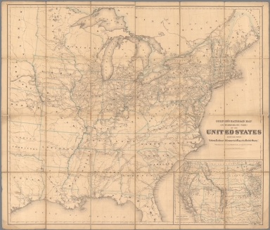
Colton's Railroad Map (Intermediate Size) Of The United States. Reduced Fom "Colton's Railroad & Commercial Map of the United States." Published By G.W. And C.B. Colton & Co. 172 William St. New York. Entered .. 1870 by G.W. & C.B. Colton & Co. ... New York. (inset) Plan Of The Western Portion of the United States.
List No
2689.000
Author
Colton, G.W. & C.B.
Full Title
(Covers to) Colton's Railroad & Commercial Atlas Of The United States, Canada Etc. Map No. 5. Michigan, Wisconsin & Minnesota. Published by G.W. & C.B. Colton. & Co. New York, 1869.
List No
0160.001
Note
This map is one of several pocket maps that Colton published as a "Railroad & Commercial Atlas of the United States..." These are probably descendants of an earlier series on the same scale that Colton published for H.V. Poor in 1860 - see Modelski North America plate 28 and Modelski 111 and 121. See also our #3940. These must have been among the largest scale regional railroad maps of the period. Full color by county, folded into stamped dark brown cloth covers 16x10 with "G. Woolworth Colton's County & Distance Railroad Map of Michigan, Wisconsin, & Minnesota. Showing every Station &c" in gilt. Prime meridians are Greenwich and Washington D.C.
Author
Colton, G.W. & C.B.
Full Title
Colton's Railroad & Commercial Atlas Of The United States, Canada Etc. Map No. 5. Michigan, Wisconsin & Minnesota. Published by G.W. & C.B. Colton. & Co. New York, 1869.
List No
0160.002
Note
This map is one of several pocket maps that Colton published as a "Railroad & Commercial Atlas of the United States..." These are probably descendants of an earlier series on the same scale that Colton published for H.V. Poor in 1860 - see Modelski North America plate 28 and Modelski 111 and 121. See also our #3940. These must have been among the largest scale regional railroad maps of the period. Full color by county, folded into stamped dark brown cloth covers 16x10 with "G. Woolworth Colton's County & Distance Railroad Map of Michigan, Wisconsin, & Minnesota. Showing every Station &c" in gilt. Prime meridians are Greenwich and Washington D.C.
Author
Colton, G.W. & C.B.
Full Title
(Covers to) Colton's New Rail Road & County Map Of The United States, The Canadas &c. 1871. Published By G.W. And C.B. Colton, 172 William St. New York. Entered ... 1869 by G.W. & C.B. Colton & Co ... New York. (inset) Colton's Map Of The United States showing the Proposed Railroad Routes To The Pacific Ocean. (inset) Southern Part Of Florida.
List No
0163.001
Note
This is a later version of our #4812, with the map extended west to the 106th meridian, and the first tier of eastern counties in Dakota shown, along with further county development in Nebraska and Kansas. Folded into stamped dark brown cloth covers 15.5x10 with "Colton's Rail Road And County Map Of The United States Canadas &c. G.W. & C.B. Colton. New York." in gilt. Full color by county. Prime meridians are Greenwich and Washington D.C.
Author
Colton, G.W. & C.B.
Full Title
(Covers to) Colton's New Rail Road & County Map Of The United States, The Canadas &c. 1871. Published By G.W. And C.B. Colton, 172 William St. New York. Entered ... 1869 by G.W. & C.B. Colton & Co ... New York. (inset) Colton's Map Of The United States showing the Proposed Railroad Routes To The Pacific Ocean. (inset) Southern Part Of Florida.
List No
0163.002
Note
This is a later version of our #4812, with the map extended west to the 106th meridian, and the first tier of eastern counties in Dakota shown, along with further county development in Nebraska and Kansas. Folded into stamped dark brown cloth covers 15.5x10 with "Colton's Rail Road And County Map Of The United States Canadas &c. G.W. & C.B. Colton. New York." in gilt. Full color by county. Prime meridians are Greenwich and Washington D.C.
Author
Colton, G.W. & C.B.
Full Title
(Covers to) Colton's Railroad & Commercial Atlas Of The United States, Canada Etc. Map No. 6. Delaware, Maryland, Virginia, West Virginia, N. Carolina, Kentucky & Tennessee. Published by G.W. And C.B. Colton, & Co. 172 William St. New York. 1870. Entered ... 1866, by G.W. & C.B. Colton & Co ... N.Y.
List No
3940.001
Note
One of a series of regional pocket railroad maps that comprised Colton's "Railroad & Commercial Atlas Of The United States..." (see our #160). Full color by county, folded into dark brown cloth covers 15.5x10 with "G. Woolworth Colton's County & Distance Railroad Map of Virginia, West Va., N. Car., Kentucky & Tennessee. Showing every Station &c" in gilt.
Author
Colton, G.W. & C.B.
Full Title
Colton's Railroad & Commercial Atlas Of The United States, Canada Etc. Map No. 6. Delaware, Maryland, Virginia, West Virginia, N. Carolina, Kentucky & Tennessee. Published by G.W. And C.B. Colton, & Co. 172 William St. New York. 1870. Entered ... 1866, by G.W. & C.B. Colton & Co ... N.Y.
List No
3940.002
Note
One of a series of regional pocket railroad maps that comprised Colton's "Railroad & Commercial Atlas Of The United States..." (see our #160). Full color by county, folded into dark brown cloth covers 15.5x10 with "G. Woolworth Colton's County & Distance Railroad Map of Virginia, West Va., N. Car., Kentucky & Tennessee. Showing every Station &c" in gilt.
Author
Colton, G.W. & C.B.
Full Title
(Covers to) Colton's New Rail Road & County Map Of The United States, The Canadas &c. Published By G.W. And C.B. Colton, 172 William St. New York. (inset) Colton's Map Of The United States showing the Proposed Railroad Routes To The Pacific Ocean. (inset) Southern Part Of Florida.
List No
4812.001
Note
This is from the same plate as our #4811, but with a different title and the counties colored separately. Extends to the 104th meridian. The date is estimated, based on the similarity to #4811. See our #163 for the edition of 1871. Folded into stamped dark brown cloth covers 16x10.5 with "Colton's Rail Road And County Map Of The United States Canadas &c. G.W. & C.B. Colton. New York." in gilt. prime meridians are Greenwich and Washington D.C.
Author
Colton, G.W. & C.B.
Full Title
Colton's New Rail Road & County Map Of The United States, The Canadas &c. Published By G.W. And C.B. Colton, 172 William St. New York. (inset) Colton's Map Of The United States showing the Proposed Railroad Routes To The Pacific Ocean. (inset) Southern Part Of Florida.
List No
4812.002
Note
This is from the same plate as our #4811, but with a different title and the counties colored separately. Extends to the 104th meridian. The date is estimated, based on the similarity to #4811. See our #163 for the edition of 1871. Folded into stamped dark brown cloth covers 16x10.5 with "Colton's Rail Road And County Map Of The United States Canadas &c. G.W. & C.B. Colton. New York." in gilt. prime meridians are Greenwich and Washington D.C.
Author
Caldwell, Joseph A.
Full Title
Map of the Pittsburg, Cincinnati and St. Louis R.R., Pan Handle Route and Principal Connections.
List No
4974.061
1-10 of 10
|