|
Author
Colton, G.W. & C.B.
Full Title
(Covers to) Colton's Railroad & Township Map of the State of Ohio. Published By G.W. & C.B. Colton, No. 172 William St. New York. 1867. Entered ... 1851 by J.H. Colton ... New York.
List No
0157.001
Note
As with all issues of this map, the primary difference between editions is the rapid railroad growth in the state. Full color by township. Map is folded into dark brown cloth covers 14.5x9 with "Colton's Township Map Of The State Of Ohio G.W. & C.B. Colton & Co." in gilt. Prime meridians are Greenwich and Washington D.C.
Author
Colton, G.W. & C.B.
Full Title
Colton's Railroad & Township Map of the State of Ohio. Published By G.W. & C.B. Colton, No. 172 William St. New York. 1867. Entered ... 1851 by J.H. Colton ... New York.
List No
0157.002
Note
As with all issues of this map, the primary difference between editions is the rapid railroad growth in the state. Full color by township. Map is folded into dark brown cloth covers 14.5x9 with "Colton's Township Map Of The State Of Ohio G.W. & C.B. Colton & Co." in gilt. Prime meridians are Greenwich and Washington D.C.
Author
Colton, G.W. & C.B.
Full Title
(Covers to) Colton's Map Of The States And Territories West Of The Mississippi River To The Pacific Ocean Showing The Overland Routes, Projected Rail Road Lines &c. Published by G.W. And C.B. Colton, & Co. 172 William St. New York. 1868. Entered ... 1867 by G.W. & C.B. Colton & Co ... New York.
List No
0158.001
Note
Changes from the 1864 edition (see our #2928) include substantial additions in northern Nevada (Williamson expedition to Silver City in 1865 provided information used in this map), the extension of southern Nevada border into Arizona, a full delineation of the Black Hills in Dakota, the Central Pacific completed to Donner Pass and the Union Pacific completed to just east of "Cheyenne's Pass," and many additional counties, principally in Nebraska and Kansas. A vine border is added, and Colton's two sons are now the publishers. Full color by county. Folded into stamped dark brown cloth covers 16x10.5 with "Colton's Map Of The States & Territories From The Mississippi River To The Pacific Ocean, &c., &c. G.W. & C.B. Colton & Co." in gilt. Relief shown by hachures.
Author
Colton, G.W. & C.B.
Full Title
Colton's Map Of The States And Territories West Of The Mississippi River To The Pacific Ocean Showing The Overland Routes, Projected Rail Road Lines &c. Published by G.W. And C.B. Colton, & Co. 172 William St. New York. 1868. Entered ... 1867 by G.W. & C.B. Colton & Co ... New York.
List No
0158.002
Note
Changes from the 1864 edition (see our #2928) include substantial additions in northern Nevada (Williamson expedition to Silver City in 1865 provided information used in this map), the extension of southern Nevada border into Arizona, a full delineation of the Black Hills in Dakota, the Central Pacific completed to Donner Pass and the Union Pacific completed to just east of "Cheyenne's Pass," and many additional counties, principally in Nebraska and Kansas. A vine border is added, and Colton's two sons are now the publishers. Full color by county. Folded into stamped dark brown cloth covers 16x10.5 with "Colton's Map Of The States & Territories From The Mississippi River To The Pacific Ocean, &c., &c. G.W. & C.B. Colton & Co." in gilt. Relief shown by hachures.
Author
Colton, G.W. & C.B.
Full Title
(Covers to) Colton's New Railroad Map Of The United States & Canada, Published by G.W. And C.B. Colton, & Co. 172 William St. New York. 1869. Entered ... 1861, by J.H. Goldthwait ... New York. (inset) Map Of The Great Railroad Routes from the Middle Atlantic Ports To The Mississippi River. (inset) Map Of The Railroads Of New England And Eastern N. York. (inset) The Northern Hemisphere On A Polar Projection, Showing the time on each meridian as compared with Washington noon, and the longest day for different latitudes.
List No
0159.001
Note
First edition by Colton - Modelski lists only an 1871 Colton edition. Shows the entire U.S. with three inset maps. The U.S. map is the same as the one that appears in Colton's General Atlas; the three inset maps are copyrighted by J.H. Goldthwait in 1861 - Goldthwait issued a similar map in 1861 (Modelski 42) that this is derived from. Full color by state. Map is folded into dark brown cloth covers 16x10 with "Colton's Railroad Map Of The United States G.W. & C.B. Colton & Co" in gilt. Prime meridians are Greenwich and Washington D.C.
Author
Colton, G.W. & C.B.
Full Title
Colton's New Railroad Map Of The United States & Canada, Published by G.W. And C.B. Colton, & Co. 172 William St. New York. 1869. Entered ... 1861, by J.H. Goldthwait ... New York. (inset) Map Of The Great Railroad Routes from the Middle Atlantic Ports To The Mississippi River. (inset) Map Of The Railroads Of New England And Eastern N. York. (inset) The Northern Hemisphere On A Polar Projection, Showing the time on each meridian as compared with Washington noon, and the longest day for different latitudes.
List No
0159.002
Note
First edition by Colton - Modelski lists only an 1871 Colton edition. Shows the entire U.S. with three inset maps. The U.S. map is the same as the one that appears in Colton's General Atlas; the three inset maps are copyrighted by J.H. Goldthwait in 1861 - Goldthwait issued a similar map in 1861 (Modelski 42) that this is derived from. Full color by state. Map is folded into dark brown cloth covers 16x10 with "Colton's Railroad Map Of The United States G.W. & C.B. Colton & Co" in gilt. Prime meridians are Greenwich and Washington D.C.
Author
Colton, G.W. & C.B.
Full Title
(Covers to) Colton's Railroad & Commercial Atlas Of The United States, Canada Etc. Map No. 5. Michigan, Wisconsin & Minnesota. Published by G.W. & C.B. Colton. & Co. New York, 1869.
List No
0160.001
Note
This map is one of several pocket maps that Colton published as a "Railroad & Commercial Atlas of the United States..." These are probably descendants of an earlier series on the same scale that Colton published for H.V. Poor in 1860 - see Modelski North America plate 28 and Modelski 111 and 121. See also our #3940. These must have been among the largest scale regional railroad maps of the period. Full color by county, folded into stamped dark brown cloth covers 16x10 with "G. Woolworth Colton's County & Distance Railroad Map of Michigan, Wisconsin, & Minnesota. Showing every Station &c" in gilt. Prime meridians are Greenwich and Washington D.C.
Author
Colton, G.W. & C.B.
Full Title
Colton's Railroad & Commercial Atlas Of The United States, Canada Etc. Map No. 5. Michigan, Wisconsin & Minnesota. Published by G.W. & C.B. Colton. & Co. New York, 1869.
List No
0160.002
Note
This map is one of several pocket maps that Colton published as a "Railroad & Commercial Atlas of the United States..." These are probably descendants of an earlier series on the same scale that Colton published for H.V. Poor in 1860 - see Modelski North America plate 28 and Modelski 111 and 121. See also our #3940. These must have been among the largest scale regional railroad maps of the period. Full color by county, folded into stamped dark brown cloth covers 16x10 with "G. Woolworth Colton's County & Distance Railroad Map of Michigan, Wisconsin, & Minnesota. Showing every Station &c" in gilt. Prime meridians are Greenwich and Washington D.C.
Author
Colton, G.W. & C.B.
Full Title
(Covers to) Colton's New Township Map of Pennsylvania & the Southern Counties Of New York. Published By G.W. & C.B. Colton & Co. 172 William Street, New York. 1869. Drawn, Engraved, Printed and colored at Coltons Geographical Establishment. No. 172 William St. New York., Entered ... 1866, by G.W. & C.B. Colton, ... New York.
List No
0161.001
Note
First edition was 1866. This large scale map was one of the most detailed Pennsylvania maps of its period (exceeded only by Colton's "New Township Map of the Eastern Counties of Pennsylvania" - our our #168). Full color by township, folded into dark brown cloth cover 16x10 with "Colton's Township Map of Pennsylvania And The Southern Counties Of New-York G.W. & C.B. Colton & Co." in gilt. Prime meridian is Washington D.C. Relief shown by hachures.
Author
Colton, G.W. & C.B.
Full Title
Colton's New Township Map of Pennsylvania & the Southern Counties Of New York. Published By G.W. & C.B. Colton & Co. 172 William Street, New York. 1869. Drawn, Engraved, Printed and colored at Coltons Geographical Establishment. No. 172 William St. New York., Entered ... 1866, by G.W. & C.B. Colton, ... New York.
List No
0161.002
Note
First edition was 1866. This large scale map was one of the most detailed Pennsylvania maps of its period (exceeded only by Colton's "New Township Map of the Eastern Counties of Pennsylvania" - our our #168). Full color by township, folded into dark brown cloth cover 16x10 with "Colton's Township Map of Pennsylvania And The Southern Counties Of New-York G.W. & C.B. Colton & Co." in gilt. Prime meridian is Washington D.C. Relief shown by hachures.
Author
Colton, G.W. & C.B.
Full Title
(Covers to) G. Woolworth Colton's New Map Of New York City, Brooklyn, Jersey City, Hoboken, Etc. Published by G.W. And C. B. Colton, & Co. 172 William St. New York. 1870. Entered ... 1865 by G. Woolworth Colton ... New York. (inset) The Upper Part Of New York City With The Adjacent Portion Of Westchester County.
List No
0162.001
Note
First issued in 1865, this 1870 edition is not in Haskell. This map has a different border and title than the Colton General Atlas version. Full color. Folded into dark brown cloth covers 14.5x9.5 with "G. Woolworth Colton's New York City Jersey City, Hoboken, Brooklyn Map and Guide" and a map of NYC stamped in gold.
Author
Colton, G.W. & C.B.
Full Title
G. Woolworth Colton's New Map Of New York City, Brooklyn, Jersey City, Hoboken, Etc. Published by G.W. And C. B. Colton, & Co. 172 William St. New York. 1870. Entered ... 1865 by G. Woolworth Colton ... New York. (inset) The Upper Part Of New York City With The Adjacent Portion Of Westchester County.
List No
0162.002
Note
First issued in 1865, this 1870 edition is not in Haskell. This map has a different border and title than the Colton General Atlas version. Full color. Folded into dark brown cloth covers 14.5x9.5 with "G. Woolworth Colton's New York City Jersey City, Hoboken, Brooklyn Map and Guide" and a map of NYC stamped in gold.
Author
Colton, G.W. & C.B.
Full Title
(Covers to) Colton's New Rail Road & County Map Of The United States, The Canadas &c. 1871. Published By G.W. And C.B. Colton, 172 William St. New York. Entered ... 1869 by G.W. & C.B. Colton & Co ... New York. (inset) Colton's Map Of The United States showing the Proposed Railroad Routes To The Pacific Ocean. (inset) Southern Part Of Florida.
List No
0163.001
Note
This is a later version of our #4812, with the map extended west to the 106th meridian, and the first tier of eastern counties in Dakota shown, along with further county development in Nebraska and Kansas. Folded into stamped dark brown cloth covers 15.5x10 with "Colton's Rail Road And County Map Of The United States Canadas &c. G.W. & C.B. Colton. New York." in gilt. Full color by county. Prime meridians are Greenwich and Washington D.C.
Author
Colton, G.W. & C.B.
Full Title
(Covers to) Colton's New Rail Road & County Map Of The United States, The Canadas &c. 1871. Published By G.W. And C.B. Colton, 172 William St. New York. Entered ... 1869 by G.W. & C.B. Colton & Co ... New York. (inset) Colton's Map Of The United States showing the Proposed Railroad Routes To The Pacific Ocean. (inset) Southern Part Of Florida.
List No
0163.002
Note
This is a later version of our #4812, with the map extended west to the 106th meridian, and the first tier of eastern counties in Dakota shown, along with further county development in Nebraska and Kansas. Folded into stamped dark brown cloth covers 15.5x10 with "Colton's Rail Road And County Map Of The United States Canadas &c. G.W. & C.B. Colton. New York." in gilt. Full color by county. Prime meridians are Greenwich and Washington D.C.
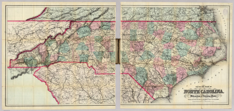
Author
Colton, G.W. & C.B.
Full Title
(Covers to) Map Of The State Of North Carolina, With Portions Of Adjoining States. Published by G.W. & C.B. Colton & Co. 182 William Street, New York, 1886.
List No
0165.001
Note
2 sheets mounted separately. Stamp on map: "Supplied by Rand McNally & Co...Chicago." Full color by county, map is folded into dark brown cloth covers 18.5x12 with "Colton's Map Of The State Of North Carolina. G.W. & C.B. Colton & Co" stamped in gold.
Author
Colton, G.W. & C.B.
Full Title
Map Of The State Of North Carolina, With Portions Of Adjoining States. Published by G.W. & C.B. Colton & Co. 182 William Street, New York, 1886.
List No
0165.002
Note
2 sheets mounted separately. Stamp on map: "Supplied by Rand McNally & Co...Chicago." Full color by county, map is folded into dark brown cloth covers 18.5x12 with "Colton's Map Of The State Of North Carolina. G.W. & C.B. Colton & Co" stamped in gold.
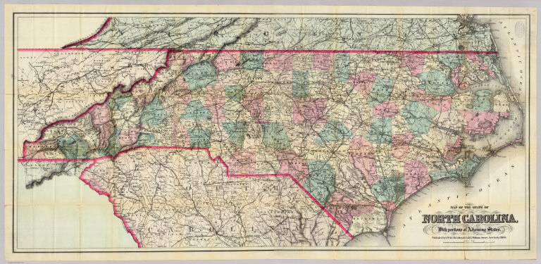
Author
Colton, G.W. & C.B.
Full Title
(Composite of) Map Of The State Of North Carolina, With Portions Of Adjoining States. Published by G.W. & C.B. Colton & Co. 182 William Street, New York, 1886.
List No
0165.003
Note
Composite of 2 sheets mounted separately. Stamp on map: "Supplied by Rand McNally & Co...Chicago." Full color by county, map is folded into dark brown cloth covers 18.5x12 with "Colton's Map Of The State Of North Carolina. G.W. & C.B. Colton & Co" stamped in gold.
Author
Colton, G.W. & C.B.
Full Title
(Covers to) Map Of The Country Thirty Three Miles Around The City Of New York. Published By G.W. And C.B. Colton, & Co., 182 William St. New York. 1887.
List No
0166.001
Note
No changes noted from the 1882 edition, other than the removal of the copyright date. Full color. Folded into dark brown cloth covers 14.5x9.5 with "Colton's Map Of The Country Thirty Three Miles Around The City Of New-York" in gilt. Prime meridians are Greenwich and Washington D.C. Relief shown by hachures, depth shown by isolines and soundings.
Author
Colton, G.W. & C.B.
Full Title
Map Of The Country Thirty Three Miles Around The City Of New York. Published By G.W. And C.B. Colton, & Co., 182 William St. New York. 1887.
List No
0166.002
Note
No changes noted from the 1882 edition, other than the removal of the copyright date. Full color. Folded into dark brown cloth covers 14.5x9.5 with "Colton's Map Of The Country Thirty Three Miles Around The City Of New-York" in gilt. Prime meridians are Greenwich and Washington D.C. Relief shown by hachures, depth shown by isolines and soundings.
Author
Colton, G.W. & C.B.
Full Title
(Covers to) Colton's New Township Map of The Eastern Counties Of Pennsylvania. G.W. & C.B. Colton & Co., 182 William St. New York 1890. Entered ... 1865, by G.W. & C.B. Colton ... New York.
List No
0168.001
Note
Late edition of this map, first published in 1866. A companion map also issued in 1866 was titled "Colton's New Township Map of The Western Counties Of Pennsylvania." Both are very large scale detailed maps of the state, although taken together they, strangely, omit the central part of the state. Full color by township, folded into black cloth covers 15.5x10 with "Colton's New Township Map of the Eastern Counties Of Pennsylvania G.W. & C.B. Colton & Co" in gilt. Prime meridians are Greenwich and Washington D.C. Relief shown by hachures.
Author
Colton, G.W. & C.B.
Full Title
Colton's New Township Map of The Eastern Counties Of Pennsylvania. G.W. & C.B. Colton & Co., 182 William St. New York 1890. Entered ... 1865, by G.W. & C.B. Colton ... New York.
List No
0168.002
Note
Late edition of this map, first published in 1866. A companion map also issued in 1866 was titled "Colton's New Township Map of The Western Counties Of Pennsylvania." Both are very large scale detailed maps of the state, although taken together they, strangely, omit the central part of the state. Full color by township, folded into black cloth covers 15.5x10 with "Colton's New Township Map of the Eastern Counties Of Pennsylvania G.W. & C.B. Colton & Co" in gilt. Prime meridians are Greenwich and Washington D.C. Relief shown by hachures.
Author
Colton, G.W. & C.B.
Full Title
(Covers to) Township Map Of The States Of New Hampshire And Vermont. Published by G.W. & C.B. Colton, & Co. New York, 1891.
List No
0169.001
Note
A late Colton imprint. 1897 was firm's last year. Full color by township, folded into dark brown cloth covers 14.5x9 with "Colton's Map Of Vermont And New-Hampshire" in gilt. Prime meridian is Greenwich.
Author
Colton, G.W. & C.B.
Full Title
Township Map Of The States Of New Hampshire And Vermont. Published by G.W. & C.B. Colton, & Co. New York, 1891.
List No
0169.002
Note
A late Colton imprint. 1897 was firm's last year. Full color by township, folded into dark brown cloth covers 14.5x9 with "Colton's Map Of Vermont And New-Hampshire" in gilt. Prime meridian is Greenwich.
Author
Colton, G.W. & C.B.
Full Title
(Covers to) Colton's Map Of The County Of Westchester. Drawn, Engraved and Published by G.W. & C.B. Colton & Co. 172 William St. New York. 1867. Entered ... 1867 by G.W. & C.B Colton & Co. ... New York.
List No
1694.001
Note
1st edition. Shows the emerging suburbs in the southern part of the county, along with railroads and historic sites. Full color by township. Folded into dark brown cloth covers 14.5x9.5 with "Map Of Westchester County G.W. & C.B. Colton & Co." in gilt.
Author
Colton, G.W. & C.B.
Full Title
Colton's Map Of The County Of Westchester. Drawn, Engraved and Published by G.W. & C.B. Colton & Co. 172 William St. New York. 1867. Entered ... 1867 by G.W. & C.B Colton & Co. ... New York.
List No
1694.002
Note
1st edition. Shows the emerging suburbs in the southern part of the county, along with railroads and historic sites. Full color by township. Folded into dark brown cloth covers 14.5x9.5 with "Map Of Westchester County G.W. & C.B. Colton & Co." in gilt.
Author
Colton, G.W. & C.B.
Full Title
(Covers to) Map showing the Line of The New Haven, Middletown And Boston Railroad and its connections. Published by G.W. And C.B. Colton, & Co. 172 William St. New York. 1867. Entered ... 1867 by G.W. & C.B. Colton & Co ... New York.
List No
1695.001
Note
Shows all of New England, with the White Mountains drawn in. Also has a Table of Distances. Includes a small box below the title: "Maps of every description to accompany Reports Prospectuses etc. Drawn Engraved Printed & Colored at Coltons Geographical Establishment No. 172 William St. New York." This advertising box appears in many Colton maps from the mid 1860's to about 1875. Uncolored, except for blue and red railroad routes. Map is folded into dark brown cloth covers 14.5x9 with "Colton's Map Showing The New-Haven, Middletown, And Boston Railroad, And its Connections. G.W. & C.B. Colton & Co." stamped in gilt. Prime meridian is Washington D.C.
Author
Colton, G.W. & C.B.
Full Title
Map showing the Line of The New Haven, Middletown And Boston Railroad and its connections. Published by G.W. And C.B. Colton, & Co. 172 William St. New York. 1867. Entered ... 1867 by G.W. & C.B. Colton & Co ... New York.
List No
1695.002
Note
Shows all of New England, with the White Mountains drawn in. Also has a Table of Distances. Includes a small box below the title: "Maps of every description to accompany Reports Prospectuses etc. Drawn Engraved Printed & Colored at Coltons Geographical Establishment No. 172 William St. New York." This advertising box appears in many Colton maps from the mid 1860's to about 1875. Uncolored, except for blue and red railroad routes. Map is folded into dark brown cloth covers 14.5x9 with "Colton's Map Showing The New-Haven, Middletown, And Boston Railroad, And its Connections. G.W. & C.B. Colton & Co." stamped in gilt. Prime meridian is Washington D.C.
Author
Colton, G.W. & C.B.
Full Title
(Covers to) Colton's New Township Map of the State of Pennsylvania. Published by G.W. & C.B. Colton & Co. New York, 1870. Entered ... 1865 by G. Woolworth Colton ... New York.
List No
1697.001
Note
This is taken from the Colton General Atlas map. Full color by township. Map is folded into dark brown cloth covers 14.5x9 with the title "New Township Map Of Pennsylvania G.W. & C.B. Colton & Co" printed in gilt. Prime meridians are Greenwich ad Washington D.C. Relief shown by hachures.
Author
Colton, G.W. & C.B.
Full Title
Colton's New Township Map of the State of Pennsylvania. Published by G.W. & C.B. Colton & Co. New York, 1870. Entered ... 1865 by G. Woolworth Colton ... New York.
List No
1697.002
Note
This is taken from the Colton General Atlas map. Full color by township. Map is folded into dark brown cloth covers 14.5x9 with the title "New Township Map Of Pennsylvania G.W. & C.B. Colton & Co" printed in gilt. Prime meridians are Greenwich ad Washington D.C. Relief shown by hachures.
Author
Colton, G.W. & C.B.
Full Title
(Covers to) Colton's New Sectional Map Of The State Of Nebraska. G.W. & C.B. Colton & Co. 172 William Street New York. 1870. Entered ... 1865, by G.W. & C.B. Colton ... New York. (inset) Map showing the Relation of Nebraska to the Adjoining States & Territories.
List No
1698.001
Note
First edition was 1866, with Karrow showing other editions of 1867, 1868, 1869, 1870, 1873 and 1875. The main map does not show the western portions of the state, leaving that to the smaller scale inset map. Excellent detail on the recently completed Union Pacific railroad. Full color by county, folded into stamped dark brown cloth covers 15.5x10 with "Sectional Map Of Nebraska And Part Of Dakota G.W. & C.B. Colton & Co." stamped in gilt. Prime meridians are Greenwich and Washingtin D.C.
Author
Colton, G.W. & C.B.
Full Title
Colton's New Sectional Map Of The State Of Nebraska. G.W. & C.B. Colton & Co. 172 William Street New York. 1870. Entered ... 1865, by G.W. & C.B. Colton ... New York. (inset) Map showing the Relation of Nebraska to the Adjoining States & Territories.
List No
1698.002
Note
First edition was 1866, with Karrow showing other editions of 1867, 1868, 1869, 1870, 1873 and 1875. The main map does not show the western portions of the state, leaving that to the smaller scale inset map. Excellent detail on the recently completed Union Pacific railroad. Full color by county, folded into stamped dark brown cloth covers 15.5x10 with "Sectional Map Of Nebraska And Part Of Dakota G.W. & C.B. Colton & Co." stamped in gilt. Prime meridians are Greenwich and Washingtin D.C.
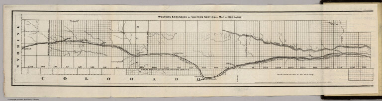
Author
Colton, G.W. & C.B.
Full Title
(Covers to) Colton's New Sectional Map Of The State Of Nebraska. G.W. & C.B. Colton & Co. 172 William Street New York. 1872. Entered ... 1865, by G.W. & C.B. Colton ... New York. (inset) Map showing the Relation of Nebraska to the Adjoining States & Territories. (with) Western Extension Of Colton's Sectional Map Of Nebraska. Entered ... 1865 by G.W. & C.B. Colton & Co ... New York.
List No
1700.001
Note
This edition adds an unusual, uncolored "Western Extension..." on the same scale as the main map, showing the route of the Union Pacific railroad to the Wyoming border. Although the extension is copyrighted 1865, Karrow does not show it included with the main map until the 1873 edition. On the main map, compared to the 1870 issue, several new counties are named in the western parts of the state, as well as new railroads. Full color by county, folded into stamped dark brown cloth covers 15.5x10 with "Sectional Map Of Nebraska And Part Of Dakota G.W. & C.B. Colton & Co." stamped in gilt. Prime meridians are Greenwich and Washington D.C.
Author
Colton, G.W. & C.B.
Full Title
Western Extension Of Colton's Sectional Map Of Nebraska. (with) Colton's New Sectional Map Of The State Of Nebraska. G.W. & C.B. Colton & Co. 172 William Street New York. 1872. Entered ... 1865, by G.W. & C.B. Colton ... New York. (inset) Map showing the Relation of Nebraska to the Adjoining States & Territories. Entered ... 1865 by G.W. & C.B. Colton & Co ... New York.
List No
1700.002
Note
This edition adds an unusual, uncolored "Western Extension..." on the same scale as the main map, showing the route of the Union Pacific railroad to the Wyoming border. Although the extension is copyrighted 1865, Karrow does not show it included with the main map until the 1873 edition. On the main map, compared to the 1870 issue, several new counties are named in the western parts of the state, as well as new railroads. Full color by county, folded into stamped dark brown cloth covers 15.5x10 with "Sectional Map Of Nebraska And Part Of Dakota G.W. & C.B. Colton & Co." stamped in gilt. Prime meridians are Greenwich and Washington D.C.
Author
Colton, G.W. & C.B.
Full Title
Colton's New Sectional Map Of The State Of Nebraska. G.W. & C.B. Colton & Co. 172 William Street New York. 1872. Entered ... 1865, by G.W. & C.B. Colton ... New York. (inset) Map showing the Relation of Nebraska to the Adjoining States & Territories. (with) Western Extension Of Colton's Sectional Map Of Nebraska. Entered ... 1865 by G.W. & C.B. Colton & Co ... New York.
List No
1700.003
Note
This edition adds an unusual, uncolored "Western Extension..." on the same scale as the main map, showing the route of the Union Pacific railroad to the Wyoming border. Although the extension is copyrighted 1865, Karrow does not show it included with the main map until the 1873 edition. On the main map, compared to the 1870 issue, several new counties are named in the western parts of the state, as well as new railroads. Full color by county, folded into stamped dark brown cloth covers 15.5x10 with "Sectional Map Of Nebraska And Part Of Dakota G.W. & C.B. Colton & Co." stamped in gilt. Prime meridians are Greenwich and Washington D.C.
Author
Colton, G.W. & C.B.
Full Title
(Covers to) Colton's Delaware And Maryland. Published By G.W. And C.B. Colton & Co. No. 172 William St. New York. 1873. Entered ... 1855 by J.H. Colton & Co ... New York. (inset) District Of Columbia.
List No
1701.001
Note
From the Colton General Atlas map of the same title. Full color by county, folded into brown cloth covers 12.5x8.5 with "Colton's Map Of Maryland And Delaware G.W. & C.B. Colton & Co" in gilt. Prime meridians are Greenwich and Washington D.C. Relief shown by hachures.
Author
Colton, G.W. & C.B.
Full Title
Colton's Delaware And Maryland. Published By G.W. And C.B. Colton & Co. No. 172 William St. New York. 1873. Entered ... 1855 by J.H. Colton & Co ... New York. (inset) District Of Columbia.
List No
1701.002
Note
From the Colton General Atlas map of the same title. Full color by county, folded into brown cloth covers 12.5x8.5 with "Colton's Map Of Maryland And Delaware G.W. & C.B. Colton & Co" in gilt. Prime meridians are Greenwich and Washington D.C. Relief shown by hachures.
Author
Colton, G.W. & C.B.
Full Title
(Covers to) Colton's Map Of The Middle States Showing The Counties, Towns, Railroads, and Stations. Published By G.W. And C.B. Colton & Co. 172 William St. New York. 1874. Entered ... 1872 by G.W. & C.B. Colton & Co. ... Washington.
List No
2074.001
Note
Front of the dark brown cloth covers 20/5x10.5 reads "Colton's Railroad Map of the Middle States. G.W. & C.B. Colton & Co." stamped in gold. Inside cover: plate of J.L. Smith (successor to R.L. Barnes), Map Publisher, Philadelphia. Full color by state.
Author
Colton, G.W. & C.B.
Full Title
Colton's Map Of The Middle States Showing The Counties, Towns, Railroads, and Stations. Published By G.W. And C.B. Colton & Co. 172 William St. New York. 1874. Entered ... 1872 by G.W. & C.B. Colton & Co. ... Washington.
List No
2074.002
Note
Front of the dark brown cloth covers 20/5x10.5 reads "Colton's Railroad Map of the Middle States. G.W. & C.B. Colton & Co." stamped in gold. Inside cover: plate of J.L. Smith (successor to R.L. Barnes), Map Publisher, Philadelphia. Full color by state. Prime meridians are Greenwich and Washington D.C.
Author
Colton, G.W. & C.B.
Full Title
(Covers to) Colton's Railroad & Township Map Of The State Of New York, With Parts of the Adjoining States & Canada. Published by G.W. And C.B. Colton & Co. No. 172 William St. New York 1868. Entered ... 1852, by J.H. Colton ... N. York. Drawn by Geo. W. Colton.
List No
2135.001
Note
Small changes when compared to our 1855 edition (see #179), just a few railroads added. Still drawn by G.W. Colton, but Atwood's name removed as "Sculpt". Map is folded into dark brown cloth covers 14.5x9.5 with "Colton's Township Map Of The State Of New-York G.W. & C.B. Colton & Co." in gilt. Full color by township. Prime meridians are Greenwich and Washington D.C. Relief shown by hachures.
Author
Colton, G.W. & C.B.
Full Title
Colton's Railroad & Township Map Of The State Of New York, With Parts of the Adjoining States & Canada. Published by G.W. And C.B. Colton & Co. No. 172 William St. New York 1868. Entered ... 1852, by J.H. Colton ... N. York. Drawn by Geo. W. Colton.
List No
2135.002
Note
Small changes when compared to our 1855 edition (see #179), just a few railroads added. Still drawn by G.W. Colton, but Atwood's name removed as "Sculpt". Map is folded into dark brown cloth covers 14.5x9.5 with "Colton's Township Map Of The State Of New-York G.W. & C.B. Colton & Co." in gilt. Full color by township. Prime meridians are Greenwich and Washington D.C. Relief shown by hachures.
Author
Colton, G.W. & C.B.
Full Title
(Covers to) Colton's Dollar Series of Sectional Maps. Missouri. Published By G.W. & C.B. Colton & Co. 172 William St. New York. Rufus Blanchard Chicago Ill. 1871. For fuller details of the geography of this state refer to Coltons larger and more complete Sectional Map Price $1.50. Entered ... 1871 by G.W. & C.B. Colton & Co ... Washington.
List No
2363.001
Note
This is Colton's "cheap" map of Missouri, probably competition for Cram and Watson (see our copies). Blanchard's name listed as publisher indicates that Blanchard collaborated with the Coltons on the Dollar Map Series. Map is folded into dark brown cloth covers 15x10 with "Colton's Dollar Series Of Sectional Maps Missouri G.W. & C.B. Colton & Co" and a decorative stamp and "1" stamped in gilt. Full color by county. Prime meridian is Greenwich.
Author
Colton, G.W. & C.B.
Full Title
Colton's Dollar Series of Sectional Maps. Missouri. Published By G.W. & C.B. Colton & Co. 172 William St. New York. Rufus Blanchard Chicago Ill. 1871. For fuller details of the geography of this state refer to Coltons larger and more complete Sectional Map Price $1.50. Entered ... 1871 by G.W. & C.B. Colton & Co ... Washington.
List No
2363.002
Note
This is Colton's "cheap" map of Missouri, probably competition for Cram and Watson (see our copies). Blanchard's name listed as publisher indicates that Blanchard collaborated with the Coltons on the Dollar Map Series. Map is folded into dark brown cloth covers 15x10 with "Colton's Dollar Series Of Sectional Maps Missouri G.W. & C.B. Colton & Co" and a decorative stamp and "1" stamped in gilt. Full color by county. Prime meridian is Greenwich.
Author
Colton, G.W. & C.B.
Full Title
(Covers to) Colton's Popular Series of Sectional Maps. Illinois. Published By G.W. & C.B. Colton & Co. 172 William St. New York. Rufus Blanchard Chicago Ill. 1872. For fuller details of the geography of this state refer to Coltons larger and more complete Sectional Map. Entered ... 1870 by G.W. & C.B. Colton & Co ... Washington.
List No
2368.001
Note
This is one of the maps from the Colton/Blanchard Dollar Series, but it has "Popular" in the title, instead of the usual "Dollar." This was their cheap version of the Peck and Messinger map (see our copies) which is referred to in the title as "Coltons larger and more complete Sectional Map." Full color by county, folded into black cloth covers 15.5x10 with "Colton's Dollar Series Of Sectional Maps Illinois G.W. & C.B. Colton & Co" printed with decorative stamp and a number "1" in gilt. Prime meridians are Greenwich and Washington D.C.
Author
Colton, G.W. & C.B.
Full Title
Colton's Popular Series of Sectional Maps. Illinois. Published By G.W. & C.B. Colton & Co. 172 William St. New York. Rufus Blanchard Chicago Ill. 1872. For fuller details of the geography of this state refer to Coltons larger and more complete Sectional Map. Entered ... 1870 by G.W. & C.B. Colton & Co ... Washington.
List No
2368.002
Note
This is one of the maps from the Colton/Blanchard Dollar Series, but it has "Popular" in the title, instead of the usual "Dollar." This was their cheap version of the Peck and Messinger map (see our copies) which is referred to in the title as "Coltons larger and more complete Sectional Map." Full color by county, folded into black cloth covers 15.5x10 with "Colton's Dollar Series Of Sectional Maps Illinois G.W. & C.B. Colton & Co" printed with decorative stamp and a number "1" in gilt. Prime meridians are Greenwich and Washington D.C.
Author
Colton, G.W. & C.B.
Full Title
(Covers to) Map Of The Country Thirty Three Miles Around The City Of New York. Published By G.W. And C.B. Colton, & Co., 182 William St. New York. Entered ... 1846, by J.H. Colton ... New York. 1882.
List No
2476.001
Note
Still more railroads are added, compared to the 1876 edition. An unknown "L.A. Roberts" is listed as the Colton's partner on the inside cover paste down ad. Folded into dark brown cloth covers 14.5x9 with "Colton's Map Of The Country Thirty Three Miles Around The City Of New-York G.W. & C.B. Colton & Co" in gilt. Full color. Prime meridians are Greenwich and Washington D.C. Relief shown by hachures, depth shown by isolines and soundings.
Author
Colton, G.W. & C.B.
Full Title
Map Of The Country Thirty Three Miles Around The City Of New York. Published By G.W. And C.B. Colton, & Co., 182 William St. New York. Entered ... 1846, by J.H. Colton ... New York. 1882.
List No
2476.002
Note
Still more railroads are added, compared to the 1876 edition. An unknown "L.A. Roberts" is listed as the Colton's partner on the inside cover paste down ad. Folded into dark brown cloth covers 14.5x9 with "Colton's Map Of The Country Thirty Three Miles Around The City Of New-York G.W. & C.B. Colton & Co" in gilt. Full color. Prime meridians are Greenwich and Washington D.C. Relief shown by hachures, depth shown by isolines and soundings.
Author
Colton, G.W. & C.B.
Full Title
(Covers to) Colton's New Map of Missouri Compiled from the U.S. Surveys and other authentic sources. Published by G.W. And C.B. Colton, & Co. No. 172 William Street, New York, 1870. Entered ... 1851 by J.H. Colton ... N. York.
List No
2986.001
Note
This is a late, unlisted edition. See our 1854 edition (#3162). Colton also published a larger and smaller map of Missouri. There must have been great demand for Missouri maps after the Civil War - Cram and Watson also published large maps of the state (see our copies). Full color by county. Folded into stamped dark brown cloth covers 14.5x9 with "Colton's Township Map Of The State Of Missouri G.W. & C.B. Colton & Co. in gilt. Prime meridians are Greenwich and Washington D.C.
Author
Colton, G.W. & C.B.
Full Title
Colton's New Map of Missouri Compiled from the U.S. Surveys and other authentic sources. Published by G.W. And C.B. Colton, & Co. No. 172 William Street, New York, 1870. Entered ... 1851 by J.H. Colton ... N. York.
List No
2986.002
Note
This is a late, unlisted edition. See our 1854 edition (#3162). Colton also published a larger and smaller map of Missouri. There must have been great demand for Missouri maps after the Civil War - Cram and Watson also published large maps of the state (see our copies). Full color by county. Folded into stamped dark brown cloth covers 14.5x9 with "Colton's Township Map Of The State Of Missouri G.W. & C.B. Colton & Co. in gilt. Prime meridians are Greenwich and Washington D.C.
Author
[Colton, G.W. & C.B., Howland, S.A.]
Full Title
(Covers to) Commercial Map of New England. Worcester Mass. S.A. Howland 1871. G.W. & C.B. Colton & Co. New York. (inset) The Northern Portion Of Maine. (with an 18 page index) Commercial Travelers' Pocket Map Of New England, Eastern New York And Long Island, Together With A Complete Census Of The New England States In 1860 and 1870. Worcester, Mass., Published By S.A. Howland. 1871. Entered ... 1871, by S.A. Howland, of Massachusetts ...
List No
3112.001
Note
Uses one of Colton's maps of New England. The map is the same base map that Colton used for the 1867 "New Haven Middletown and Boston Railroad" map (see our copy). Map is loose and folded into a cloth pouch inside burgandy cloth covers 17.5x11 which read "Commercial Traveller's Pocket Map And Census Of New England." in gold.
Author
[Colton, G.W. & C.B., Howland, S.A.]
Full Title
(Title Page to) Commercial Map of New England. Worcester Mass. S.A. Howland 1871. G.W. & C.B. Colton & Co. New York. (inset) The Northern Portion Of Maine. (with an 18 page index) Commercial Travelers' Pocket Map Of New England, Eastern New York And Long Island, Together With A Complete Census Of The New England States In 1860 and 1870. Worcester, Mass., Published By S.A. Howland. 1871. Entered ... 1871, by S.A. Howland, of Massachusetts ...
List No
3112.002
Note
Uses one of Colton's maps of New England. The map is the same base map that Colton used for the 1867 "New Haven Middletown and Boston Railroad" map (see our copy). Map is loose and folded into a cloth pouch inside burgandy cloth covers 17.5x11 which read "Commercial Traveller's Pocket Map And Census Of New England." in gold.
|