|
Author
Burr, David H., 1803-1875
Full Title
Map of the counties of New York, Queens, Kings and Richmond. By David H. Burr. Published by the Surveyor General, pursuant to an Act of the Legislature. Entered according to an Act of Congress Jany. 5th. 1829 by David H. Burr of the State of New York. Engd. by Rawdon, Clark & Co., Albany & Rawd
List No
15069.000
Note
Date estimated. Population figures are later than the 1839 edition.
Author
Burr, David H., 1803-1875
Full Title
Map of the northern parts of Ohio, Indiana and Illinois with Michigan and that part of the Ouisconsin territory lying east of the Mississippi River
List No
15634.000
Author
Burr, David H., 1803-1875
Full Title
(Covers to) A series of maps for a general atlas, compiled by David H. Burr. New York : published by David H. Burr, 189 Broadway. Sleight and Robinson, Printers. 1831.
List No
14341.001
Note
Front cover to A series of maps for a general atlas, compiled by David H. Burr and published in New York in 1831. Volume bound in paper covers, with single sheets for the front and back covers, which are attached with sewn thread. "No. 1, containing Michigan; Maine; Ohio; The Netherlands; and twenty-five miles round the city of New York." With descriptive text, beginning: There are already many collections of maps published, of various sizes and merits, but an evident deficiency in maps for the use of readers of history and students, of an intermediate size between the large and expensive maps, fit only for the library, and the smaller sort, usually adopted in schools ...
Author
Burr, David H., 1803-1875
Full Title
Map of the country twenty five miles round the city of New-York. Drawn & published by David H. Burr. New-York. Octr 20th, 1831.
List No
14341.002
Note
Round map of New York City, showing a 25-mile perimeter around the city. Features political boundaries, cities, roads, canals, topography, vegetation, drainage, shorelines and islands. Relief shown with hachures. Includes a bar scale, given in American miles, as well as points of latitude and longitude. With descriptive text throughout, such as: Perpendicular rocks from 200 to 500 feet high. Hand-colored engraving. Map is 26 x 26 cm, on sheet 43 x 35 cm. "Entered according to act of Congress in the year 1831 by David H. Burr, in the Clerk's office of the District Court for the Southern District of New-York."
Author
Burr, David H., 1803-1875
Full Title
Michigan. Drawn and published by David H. Burr. New-York.
List No
14341.003
Note
Map of Michigan and vicinity, including the Great Lakes. Shows political boundaries, cities, roads, water routes, topography, vegetation, drainage, shorelines and islands. Relief shown with hachures. Features the "Indian boundary line according to the Saginaw Treaty." Includes a bar scale, given in American miles, as well as latitudinal and longitudinal lines. Hand-colored engraving. Map is 31 x 25 cm, on sheet 43 x 35 cm. "Entered according to act of Congress in the year 1831 by David H. Burr, in the Clerk's office of the District Court for the Southern District of New-York."
Author
Burr, David H., 1803-1875
Full Title
Ohio. Drawn and published by David H. Burr. New-York.
List No
14341.004
Note
Map of Ohio and vicinity. Shows political boundaries, cities, roads, canals, water routes, drainage, shorelines and islands. Features the Seneca Indian Reservation, in Seneca County. Includes a bar scale, given in American miles, as well as latitudinal and longitudinal lines. Hand-colored engraving. Map is 25 x 30 cm, on sheet 35 x 43 cm. "Entered according to act of Congress in the year 1831 by David H. Burr, in the Clerk's office of the District Court for the Southern District of New-York."
Author
Burr, David H., 1803-1875
Full Title
Maine. Drawn and published by David H. Burr. New-York.
List No
14341.005
Note
Map of Maine and vicinity. Shows political boundaries, cities, roads, topography, drainage, shorelines and islands. Relief shown with hachures. Includes a bar scale, given in American miles, as well as latitudinal and longitudinal lines. Hand-colored engraving. Map is 33 x 25 cm, on sheet 43 x 35 cm. "Entered according to act of Congress in the year 1831 by David H. Burr, in the Clerk's office of the District Court for the Southern District of New-York."
Author
Burr, David H., 1803-1875
Full Title
The Kingdom of the Netherlands. Drawn and published by David H. Burr. New-York.
List No
14341.006
Note
Map of the Nethlands and vicinity. Shows political boundaries, cities, roads, canals, topography, vegetation, drainage, shorelines and islands. Relief shown with hachures. Includes five bar scales, given in Dutch and German miles, Flemish miles, French leagues, French post leagues and British miles, as well as latitudinal and longitudinal lines. Hand-colored engraving. Map is 32 x 25 cm, on sheet 43 x 35 cm. "Entered according to act of Congress, Novr. 11th in the year 1831 by David H. Burr, in the Clerk's office of the District Court for the Southern District of New-York."
Author
Burr, David H., 1803-1875
Full Title
(Covers to) Editorial notices.
List No
14341.007
Note
Back cover to A series of maps for a general atlas, compiled by David H. Burr and published in New York in 1831. Volume bound in paper covers, with single sheets for the front and back covers, which are attached with sewn thread. With editorial notices describing the atlas from eleven different periodicals, including the New York Commercial Advertiser, which begins: Burr's atlas. David H. Burr, 189 Broadway, has published the first number of a series of maps, which he intends to continue, until the whole will form a general atlas.
Author
Burr, David H., 1803-1875
Full Title
(Title Page) An Atlas Of The State of New York, Containing A Map of the State And Of The Several Counties ... under the superintendance & direction of Simeon DeWitt, Surveyor General, pursuant to an Act of the Legislature, And also the Physical Geography of the State & of the several Counties & Statistical Tables of the Same, By David H. Burr. New York, Published by David H. Burr. 1829. RePublished At Ithaca, N.Y. By Stone And Clark With Corrections And Improvements. 1840. Engravd. by Rawdon, Clark & Co. Albany & Rawdon, Wright & Co., New York.
List No
0105.002
Note
Includes vignette of "View on the Hudson River near Fishkill".
Author
Burr, David H., 1803-1875
Full Title
Map of the State of New-York and the Surrounding Country.
List No
0105.025
Author
Burr, David H., 1803-1875
Full Title
Map of the City and County of New York.
List No
0105.026
Note
Foldout. Third edition.
Author
Burr, David H., 1803-1875
Full Title
Map of the Counties of New York, Queens, Kings, and Richmond.
List No
0105.028
Author
Burr, David H., 1803-1875
Full Title
Map of the United States Of North America, By David H. Burr. Geographer to the House of Representatives of the U.S. . Entered ... 12th Jan. 1842, by David H. Burr ... District of Columbia.
List No
5805.000
Note
This large four sheet wall map of the United States west to the 100th meridian must have been intended to accompany Burr's 1839 thirteen sheet American Atlas of postal wall maps (see our 0104.000), although there is little record of its publishing other than a listing in Phillips Maps of America, p.896. The American Atlas has a large map of the United States from coast to coast, but it lacks the detail of this wall map, which shows all most all of the postal roads, canals, and railroads that are delineated on the large scale individual state maps of the American Atlas. That detail makes this wall map one of the best large area road maps of the United States as a whole, of the period - more detailed than Tanner's Map of the United States or Mitchell's Reference and Distance Map of the United States. Burr likely published it as an addendum to the American Atlas to give a larger overview of the road system of the entire United States. Ristow (p.106) mentions that Burr published an edition of the American Atlas in 1842, so it is likely that this map was added to the set then. We are presuming that John Arrowsmith was the publisher and printer because of the similarity of style between this wall map and the American Atlas which he published for Burr, but his name does not appear on the map. There is no key or legend, only a scale of miles, and only two classes of roads are shown, primary and secondary, compared to four classes of roads shown on the American Atlas state maps. In the lower right corner is an untitled inset map of North and South America that is a slighly simplified version of part of John Arrowsmith's Map of the World on Mercators Projection, 1844 (see our 4613.002), further evidence of the John Arrowsmith involvement in publishing this wall map.
Author
Burr, David H., 1803-1875
Full Title
Map of the United States Of North America With parts of the Adjacent Countries, By David H. Burr. (Late Topographer to the Post Office.) Geographer to the House of Representatives of the U.S. John Arrowsmith. Entered ... July 10th, 1839, by David H. Burr ... District of Columbia.
List No
0104.001
Note
This is the "Map of the United States of North America..." from Burr's American Atlas which consists of 13 separate sheets dissected & mounted on linen. In full color by state, country, or region. In 8 sections mounted on linen. Label on back states "No. 1. United States."
Author
[Burr, David H., 1803-1875, Colton, J. H.]
Full Title
(Covers to) United States. By David H. Burr. Published by J.H. Colton & Co. New York. 9 Wall Street. 1833. Engraved by S. Stiles & Co., N. York. Entered ... 1833, by J.H. Colton & Co. ... New York.
List No
0110A
Note
Dark teal leather covers 13.5x8 with "Burr's Map of the United States Published By J.H. Colton & Co. New York" and a decorative border stamped in gilt.
Author
[Burr, David H., 1803-1875, Colton, J. H.]
Full Title
United States. By David H. Burr. Published by J.H. Colton & Co. New York. 9 Wall Street. 1833. Engraved by S. Stiles & Co., N. York. Entered ... 1833, by J.H. Colton & Co. ... New York.
List No
0110.001
Note
This is the first year of Colton's map publishing business. Ristow says that Colton published his first map in 1833, Burr's map of New York State; this U.S. map must be as early. The graphic style is similar to Burr's Universal Atlas maps, engraved the following year. With six detailed and elegant inset maps showing the environs of Albany, Boston, New York, Cincinnati, Philadelphia, and Baltimore & Washington; plus a small inset map of South Part of Florida. Outline color, folded into dark teal leather covers 13.5x8 with "Burr's Map of the United States Published By J.H. Colton & Co. New York" and a decorative border stamped in gilt. Prime meridians: Greenwich and Washington.
Author
Burr, David H., 1803-1875
Full Title
(Covers to) An atlas of the State of New York, containing a map of the State and of the several counties ... under the superintendance & direction of Simeon DeWitt, Surveyor General, pursuant to an Act of the Legislature, and also the physical geography of the State & of the several counties & statistical tables of the same, by David H. Burr. New York, published by David H. Burr. 1829. Engravd. by Rawdon, Clark & Co. Albany & Rawdon, Wright & Co., New York.
List No
0103A
Note
This atlas is the second atlas published in the 19th century of one of the individual states in the U.S., preceded only by Mill's Atlas of South Carolina, issued in 1825, and followed closely, also in 1829, by Greenleaf's Atlas of the State of Maine (Ristow, p96). This copy is the 1st edition, second state, actually published in 1832. Howard Welsh rescued this copy which was obviously about to be broken up and disbound. When we acquired it from his estate it was completely disbound; subsequently we had it rebound and restored. The Map of the City and County of New York is dated 2nd. ed., 1832 ; Haskell 725 lists this as appearing in the 1829 ed. of the Atlas. Therefore, we can presume that there are two 1829 eds., the first state with this map dated 1829 (Haskell 721) and the second state which is this copy with the 1832 map (Haskell 725). The Map of New York State is also dated 1832. All other maps are dated 1829. Full hand painted color. Bound in half leather marbled paper covered boards with "New York Atlas" stamped in gilt on the spine.
Author
Burr, David H., 1803-1875
Full Title
(Half Title Page to) An atlas of the State of New York, containing a map of the State and of the several counties ... under the superintendance & direction of Simeon DeWitt, Surveyor General, pursuant to an Act of the Legislature, and also the physical geography of the State & of the several counties & statistical tables of the same, by David H. Burr. New York, published by David H. Burr. 1829. Engravd. by Rawdon, Clark & Co. Albany & Rawdon, Wright & Co., New York.
List No
0103B
Note
This atlas is the second atlas published in the 19th century of one of the individual states in the U.S., preceded only by Mill's Atlas of South Carolina, issued in 1825, and followed closely, also in 1829, by Greenleaf's Atlas of the State of Maine (Ristow, p96). This copy is the 1st edition, second state, actually published in 1832. Howard Welsh rescued this copy which was obviously about to be broken up and disbound. When we acquired it from his estate it was completely disbound; subsequently we had it rebound and restored. The Map of the City and County of New York is dated 2nd. ed., 1832 ; Haskell 725 lists this as appearing in the 1829 ed. of the Atlas. Therefore, we can presume that there are two 1829 eds., the first state with this map dated 1829 (Haskell 721) and the second state which is this copy with the 1832 map (Haskell 725). The Map of New York State is also dated 1832. All other maps are dated 1829. Full hand painted color. Bound in half leather marbled paper covered boards with "New York Atlas" stamped in gilt on the spine.
Author
Burr, David H., 1803-1875
Full Title
(Title Page to) An atlas of the State of New York, containing a map of the State and of the several counties ... under the superintendance & direction of Simeon DeWitt, Surveyor General, pursuant to an Act of the Legislature, and also the physical geography of the State & of the several counties & statistical tables of the same, by David H. Burr. (with) View on the Hudson near Fishkill. New York, published by David H. Burr. 1829. Engravd. by Rawdon, Clark & Co. Albany & Rawdon, Wright & Co., New York.
List No
0103C
Note
This atlas is the second atlas published in the 19th century of one of the individual states in the U.S., preceded only by Mill's Atlas of South Carolina, issued in 1825, and followed closely, also in 1829, by Greenleaf's Atlas of the State of Maine (Ristow, p96). This copy is the 1st edition, second state, actually published in 1832. Howard Welsh rescued this copy which was obviously about to be broken up and disbound. When we acquired it from his estate it was completely disbound; subsequently we had it rebound and restored. The Map of the City and County of New York is dated 2nd. ed., 1832 ; Haskell 725 lists this as appearing in the 1829 ed. of the Atlas. Therefore, we can presume that there are two 1829 eds., the first state with this map dated 1829 (Haskell 721) and the second state which is this copy with the 1832 map (Haskell 725). The Map of New York State is also dated 1832. All other maps are dated 1829. Full hand painted color. Bound in half leather marbled paper covered boards with "New York Atlas" stamped in gilt on the spine.
Author
Burr, David H., 1803-1875
Full Title
(Contents to) An atlas of the State of New York, containing a map of the State and of the several counties ... under the superintendance & direction of Simeon DeWitt, Surveyor General, pursuant to an Act of the Legislature, and also the physical geography of the State & of the several counties & statistical tables of the same, by David H. Burr. New York, published by David H. Burr. 1829. Engravd. by Rawdon, Clark & Co. Albany & Rawdon, Wright & Co., New York.
List No
0103D
Note
This atlas is the second atlas published in the 19th century of one of the individual states in the U.S., preceded only by Mill's Atlas of South Carolina, issued in 1825, and followed closely, also in 1829, by Greenleaf's Atlas of the State of Maine (Ristow, p96). This copy is the 1st edition, second state, actually published in 1832. Howard Welsh rescued this copy which was obviously about to be broken up and disbound. When we acquired it from his estate it was completely disbound; subsequently we had it rebound and restored. The Map of the City and County of New York is dated 2nd. ed., 1832 ; Haskell 725 lists this as appearing in the 1829 ed. of the Atlas. Therefore, we can presume that there are two 1829 eds., the first state with this map dated 1829 (Haskell 721) and the second state which is this copy with the 1832 map (Haskell 725). The Map of New York State is also dated 1832. All other maps are dated 1829. Full hand painted color. Bound in half leather marbled paper covered boards with "New York Atlas" stamped in gilt on the spine.
Author
Burr, David H., 1803-1875
Full Title
Map of the State of New-York and the surrounding country by David H. Burr. Compiled from his large map of the State, 1832. (with) Profile of the Grand Erie Canal. (with) Profile of the Champlain Canal. (with) Profile of the Seneca Canal. Entered according to Act of Congress Jany. 5th., 1829 by David H. Burr of the State of New York. Engd. by Rawdon, Clark & Co., Albany & Rawdon, Wright & Co., New York.
List No
0103.001
Note
Hand col. engraved map. Relief shown by hachures. Covers Connecticut, Rhode Island, Vermont and parts of New Hampshire, Massachusetts, New Jersey and Pennsylvania. Prime meridian: Washington, D.C.
Author
Burr, David H., 1803-1875
Full Title
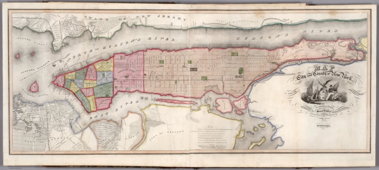
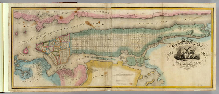
Map of the City and County of New York with the adjacent country, by David H. Burr, published by Simeon DeWitt, Surveyor General, pursuant to an Act of the Legislature. Second edition 1832.
List No
0103.002
Note
Hand col. engraved map on 2 sheets. Relief shown by hachures. Covers also Jersey City and Horsimus and other communities in N.J. Ornamental cartouche. Includes "Remarks" on streets and distances. David Rumsey Collection copy mounted as 1 sheet.
Author
Burr, David H., 1803-1875
Full Title
Map of the counties of New York, Queens, Kings and Richmond. By David H. Burr. Published by the Surveyor General, pursuant to an Act of the Legislature. Entered according to an Act of Congress Jany. 5th. 1829 by David H. Burr of the State of New York. Engd. by Rawdon, Clark & Co., Albany & Rawdon, Wright & Co., New York.
List No
0103.003
Note
Hand col. engraved map. Shows flouring mills, factories, forges, saw mills, churches, etc. Prime meridian: Washington, D.C.
Author
Burr, David H., 1803-1875
Full Title
Map of the County of Suffolk. By David H. Burr. Published by the Surveyor General, pursuant to an Act of the Legislature. Entered according to an Act of Congress Jany. 5th. 1829 by David H. Burr of the State of New York. Engd. by Rawdon, Clark & Co., Albany & Rawdon, Wright & Co., N. York.
List No
0103.004
Note
Hand col. engraved map. Shows flouring mills, factories, forges, saw mills, churches, etc. Prime meridian: Washington, D.C.
Author
Burr, David H., 1803-1875
Full Title
Map of the County of Westchester. By David H. Burr. Published by the Surveyor General, pursuant to an Act of the Legislature. Entered according to an Act of Congress Jany. 5th. 1829 by David H. Burr of the State of New York. Engd. by Rawdon, Clark & Co., Albany & Rawdon, Wright & Co., New York.
List No
0103.005
Note
Hand col. engraved map. Shows flouring mills, factories, forges, saw mills, churches, etc. Covers also part of Manhattan and the Bronx. Prime meridian: Washington, D.C.
Author
Burr, David H., 1803-1875
Full Title
Map of the counties of Dutchess and Putnam. By David H. Burr. Published by the Surveyor General, pursuant to an Act of the Legislature. Entered according to an Act of Congress Jany. 5th. 1829 by David H. Burr of the State of New York. Engd. by Rawdon, Clark & Co., Albany & Rawdon, Wright & Co., New York.
List No
0103.006
Note
Hand col. engraved map. Shows flouring mills, factories, forges, saw mills, churches, etc. Relief shown by hachures. Prime meridian: Washington, D.C.
Author
Burr, David H., 1803-1875
Full Title
Map of the counties of Orange and Rockland. By David H. Burr. Published by the Surveyor General, pursuant to an Act of the Legislature. Entered according to an Act of Congress Jany. 5th. 1829 by David H. Burr of the State of New York. Engd. by Rawdon, Clark & Co., Albany & Rawdon, Wright & Co., N. York.
List No
0103.007
Note
Hand col. engraved map. Shows flouring mills, factories, forges, saw mills, churches, landowners, etc. Relief shown by hachures. Prime meridian: Washington, D.C.
Author
Burr, David H., 1803-1875
Full Title
Map of the County of Ulster. By David H. Burr. Published by the Surveyor General, pursuant to an Act of the Legislature. Entered according to an Act of Congress Jany. 5th. 1829 by David H. Burr of the State of New York. Engd. by Rawdon, Clark & Co., Albany & Rawdon, Wright & Co., New York.
List No
0103.008
Note
Hand col. engraved map. Shows flouring mills, factories, forges, saw mills, churches, landowners, etc. Relief shown by hachures. Prime meridian: Washington, D.C.
Author
Burr, David H., 1803-1875
Full Title
Map of the County of Sullivan. By David H. Burr. Published by the Surveyor General, pursuant to an Act of the Legislature. Entered according to an Act of Congress Jany. 5th. 1829 by David H. Burr of the State of New York. Engd. by Rawdon, Clark & Co., Albany & Rawdon, Wright & Co., N. York.
List No
0103.009
Note
Hand col. engraved map. Shows flouring mills, factories, forges, saw mills, churches, parcels, landowners, etc. Relief shown by hachures. Prime meridian: Washington, D.C.
Author
Burr, David H., 1803-1875
Full Title
Map of the County of Delaware. By David H. Burr. Published by the Surveyor General, pursuant to an Act of the Legislature. Entered according to an Act of Congress Jany. 5th. 1829 by David H. Burr of the State of New York. Engd. by Rawdon, Clark & Co., Albany & Rawdon, Wright & Co., N.Y.
List No
0103.010
Note
Hand col. engraved map. Shows flouring mills, factories, forges, saw mills, churches, parcels, landowners, etc. Prime meridian: Washington, D.C.
Author
Burr, David H., 1803-1875
Full Title
Map of the County of Greene. By David H. Burr. Published by the Surveyor General, pursuant to an Act of the Legislature. Entered according to an Act of Congress Jany. 5th. 1829 by David H. Burr of the State of New York. Engd. by Rawdon, Clark & Co., Albany & Rawdon, Wright & Co., New York.
List No
0103.011
Note
Hand col. engraved map. Shows flouring mills, factories, forges, saw mills, churches, parcels, landowners, etc. Relief shown by hachures. Prime meridian: Washington, D.C.
Author
Burr, David H., 1803-1875
Full Title
Map of the County of Columbia. By David H. Burr. Published by the Surveyor General, pursuant to an Act of the Legislature. Entered according to an Act of Congress Jany. 5th. 1829 by David H. Burr of the State of New York. Engd. by Rawdon, Clark & Co., Albany & Rawdon, Wright & Co., New York.
List No
0103.012
Note
Hand col. engraved map. Shows flouring mills, factories, forges, saw mills, churches, etc. Relief shown by hachures. Prime meridian: Washington, D.C.
Author
Burr, David H., 1803-1875
Full Title
Map of the County of Rensselaer. By David H. Burr. Published by the Surveyor General, pursuant to an Act of the Legislature. Entered according to an Act of Congress Jany. 5th. 1829 by David H. Burr of the State of New York. Engd. by Rawdon, Clark & Co., Albany & Rawdon, Wright & Co., New York.
List No
0103.013
Note
Hand col. engraved map. Shows flouring mills, factories, forges, saw mills, churches, parcels, landowners, etc. Prime meridian: Washington, D.C.
Author
Burr, David H., 1803-1875
Full Title
Map of the counties of Albany and Schenectady. (with) City of Albany. By David H. Burr. Published by the Surveyor General, pursuant to an Act of the Legislature. Entered according to an Act of Congress Jany. 5th. 1829 by David H. Burr of the State of New York. Engd. by Rawdon, Clark & Co., Albany & Rawdon, Wright & Co., N.Y.
List No
0103.014
Note
Hand col. engraved map. Shows flouring mills, factories, forges, saw mills, churches, parcels, landowners, etc. Inset map shows wards, public buildings, etc. Prime meridian: Washington, D.C.
Author
Burr, David H., 1803-1875
Full Title
Map of the County of Schoharie. By David H. Burr. Published by the Surveyor General, pursuant to an Act of the Legislature. Entered according to an Act of Congress Jany. 5th. 1829 by David H. Burr of the State of New York. Engd. by Rawdon, Clark & Co., Albany & Rawdon, Wright & Co., N.Y.
List No
0103.015
Note
Hand col. engraved map. Shows flouring mills, factories, forges, saw mills, churches, parcels, landowners, etc. Prime meridian: Washington, D.C.
Author
Burr, David H., 1803-1875
Full Title
Map of the County of Montgomery. By David H. Burr. Published by the Surveyor General, pursuant to an Act of the Legislature. Entered according to an Act of Congress Jany. 5th. 1829 by David H. Burr of the State of New York. Engd. by Rawdon, Clark & Co., Alby. & Rawdon, Wright & Co., N. York.
List No
0103.016
Note
Hand col. engraved map. Shows flouring mills, factories, forges, saw mills, churches, parcels, landowners, etc. Prime meridian: Washington, D.C.
Author
Burr, David H., 1803-1875
Full Title
Map of the County of Hamilton. By David H. Burr. Published by the Surveyor General, pursuant to an Act of the Legislature. Entered according to an Act of Congress Jany. 5th. 1829 by David H. Burr of the State of New York. Engd. by Rawdon, Clark & Co., Albany & Rawdon, Wright & Co., N. York.
List No
0103.017
Note
Hand col. engraved map. Shows flouring mills, factories, forges, saw mills, churches, parcels, landowners, etc. Prime meridian: Washington, D.C.
Author
Burr, David H., 1803-1875
Full Title
Map of the County of Saratoga. By David H. Burr. Published by the Surveyor General, pursuant to an Act of the Legislature. Entered according to an Act of Congress Jany. 5th. 1829 by David H. Burr of the State of New York. Engd. by Rawdon, Clark & Co., Albany & Rawdon, Wright & Co., N. York.
List No
0103.018
Note
Hand col. engraved map. Shows flouring mills, factories, forges, saw mills, churches, parcels, landowners, etc. Prime meridian: Washington, D.C.
Author
Burr, David H., 1803-1875
Full Title
Map of the County of Washington. By David H. Burr. Published by the Surveyor General, pursuant to an Act of the Legislature. Entered according to an Act of Congress Jany. 5th. 1829 by David H. Burr of the State of New York. Engd. by Rawdon, Clark & Co., Albany & Rawdon, Wright & Co., New York.
List No
0103.019
Note
Hand col. engraved map on 2 sheets. Shows flouring mills, factories, forges, saw mills, churches, parcels, landowners, etc. Prime meridian: Washington, D.C. David Rumsey Collection copy mounted as 1 sheet.
Author
Burr, David H., 1803-1875
Full Title
Map of the County of Warren. By David H. Burr. Published by the Surveyor General, pursuant to an Act of the Legislature. Entered according to an Act of Congress Jany. 5th. 1829 by David H. Burr of the State of N. York. Engd. by Rawdon, Clark & Co., Albany & Rawdon, Wright & Co., N.Y.
List No
0103.020
Note
Hand col. engraved map. Shows flouring mills, factories, forges, saw mills, churches, parcels, landowners, etc. Prime meridian: Washington, D.C.
Author
Burr, David H., 1803-1875
Full Title
Map of the County of Essex. By David H. Burr. Published by the Surveyor General, pursuant to an Act of the Legislature. Entered according to an Act of Congress Jany. 5th. 1829 by David H. Burr of the State of New York. Engd. by Rawdon, Clark & Co., Albany & Rawdon, Wright & Co., New York.
List No
0103.021
Note
Hand col. engraved map. Shows flouring mills, factories, forges, saw mills, churches, parcels, landowners, etc. Prime meridian: Washington, D.C.
Author
Burr, David H., 1803-1875
Full Title
Map of the County of Clinton. By David H. Burr. Published by the Surveyor General, pursuant to an Act of the Legislature. Entered according to an Act of Congress Jany. 5th. 1829 by David H. Burr of the State of New York. Engd. by Rawdon, Clark & Co., Albany & Rawdon, Wright & Co., N. York.
List No
0103.022
Note
Hand col. engraved map. Shows flouring mills, factories, forges, saw mills, churches, parcels, landowners, etc. Prime meridian: Washington, D.C.
Author
Burr, David H., 1803-1875
Full Title
Map of the County of Franklin. By David H. Burr. Published by the Surveyor General, pursuant to an Act of the Legislature. Entered according to an Act of Congress Jany. 5th. 1829 by David H. Burr of the State of New York. Engd. by Rawdon, Clark & Co., Albany & Rawdon, Wright & Co., New York.
List No
0103.023
Note
Hand col. engraved map on 2 sheets. Shows flouring mills, factories, forges, saw mills, churches, parcels, landowners, etc. Prime meridian: Washington, D.C. David Rumsey Collection copy mounted as 1 sheet.
Author
Burr, David H., 1803-1875
Full Title
Map of the County of St. Lawrence. By David H. Burr. Published by the Surveyor General, pursuant to an Act of the Legislature. Entered according to an Act of Congress Jany. 5th. 1829 by David H. Burr of the State of New York. Engd. by Rawdon, Clark & Co., Alby. & Rawdon, Wright & Co., N. York.
List No
0103.024
Note
Hand col. engraved map on 2 sheets. Shows flouring mills, factories, forges, saw mills, churches, parcels, landowners, etc. Prime meridian: Washington, D.C. David Rumsey Collection copy mounted as 1 sheet.
Author
Burr, David H., 1803-1875
Full Title
Map of the County of Jefferson. By David H. Burr. Published by the Surveyor General, pursuant to an Act of the Legislature. Entered according to an Act of Congress Jany. 5th. 1829 by David H. Burr of the State of New York. Engd. by Rawdon, Clark & Co., Albany & Rawdon, Wright & Co., N. York.
List No
0103.025
Note
Hand col. engraved map. Shows flouring mills, factories, forges, saw mills, churches, parcels, landowners, etc. Prime meridian: Washington, D.C.
Author
Burr, David H., 1803-1875
Full Title
Map of the County of Lewis. By David H. Burr. Published by the Surveyor General, pursuant to an Act of the Legislature. Entered according to an Act of Congress Jany. 5th. 1829 by David H. Burr of the State of New York. Engd. by Rawdon, Clark & Co., Alby. & Rawdon, Wright & Co., New York.
List No
0103.026
Note
Hand col. engraved map. Shows flouring mills, factories, forges, saw mills, churches, parcels, landowners, etc. Prime meridian: Washington, D.C.
Author
Burr, David H., 1803-1875
Full Title
Map of the County of Herkimer. By David H. Burr. Published by the Surveyor General, pursuant to an Act of the Legislature. Entered according to an Act of Congress Jany. 5th. 1829 by David H. Burr of the State of New York. Engd. by Rawdon, Clark & Co., Albany & Rawdon, Wright & Co., New York.
List No
0103.027
Note
Hand col. engraved map. Shows flouring mills, factories, forges, saw mills, churches, parcels, landowners, etc. Printed in 2 segments. Prime meridian: Washington, D.C.
Author
Burr, David H., 1803-1875
Full Title
Map of the County of Oneida. By David H. Burr. Published by the Surveyor General, pursuant to an Act of the Legislature. Entered according to an Act of Congress Jany. 5th. 1829 by David H. Burr of the State of New York. Engd. by Rawdon, Clark & Co., Albany & Rawdon, Wright & Co., N.Y.
List No
0103.028
Note
Hand col. engraved map. Shows flouring mills, factories, forges, saw mills, churches, parcels, landowners, etc. Prime meridian: Washington, D.C.
Author
Burr, David H., 1803-1875
Full Title
Map of the County of Madison. By David H. Burr. Published by the Surveyor General, pursuant to an Act of the Legislature. Entered according to an Act of Congress Jany. 5th. 1829 by David H. Burr of the State of New York. Engd. by Rawdon, Clark & Co., Albany & Rawdon, Wright & Co., N.Y.
List No
0103.029
Note
Hand col. engraved map. Shows flouring mills, factories, forges, saw mills, churches, parcels, landowners, etc. Prime meridian: Washington, D.C.
Author
Burr, David H., 1803-1875
Full Title
Map of the County of Oswego. By David H. Burr. Published by the Surveyor General, pursuant to an Act of the Legislature. Entered according to an Act of Congress Jany. 5th. 1829 by David H. Burr of the State of New York. Engd. by Rawdon, Clark & Co., Albany & Rawdon, Wright & Co., N.Y.
List No
0103.030
Note
Hand col. engraved map. Shows flouring mills, factories, forges, saw mills, churches, parcels, landowners, etc. Prime meridian: Washington, D.C.
Author
Burr, David H., 1803-1875
Full Title
Map of the County of Otsego. By David H. Burr. Published by the Surveyor General, pursuant to an Act of the Legislature. Entered according to an Act of Congress Jany. 5th. 1829 by David H. Burr of the State of New York. Engd. by Rawdon, Clark & Co., Albany & Rawdon, Wright & Co., New York.
List No
0103.031
Note
Hand col. engraved map. Shows flouring mills, factories, forges, saw mills, churches, parcels, landowners, etc. Prime meridian: Washington, D.C.
Author
Burr, David H., 1803-1875
Full Title
Map of the County of Chenango. By David H. Burr. Published by the Surveyor General, pursuant to an Act of the Legislature. Entered according to an Act of Congress Jany. 5th. 1829 by David H. Burr of the State of New York. Engd. by Rawdon, Clark & Co., Albany & Rawdon, Wright & Co., N. York.
List No
0103.032
Note
Hand col. engraved map. Shows flouring mills, factories, forges, saw mills, churches, parcels, etc. Prime meridian: Washington, D.C.
Author
Burr, David H., 1803-1875
Full Title
Map of the County of Broome. By David H. Burr. Published by the Surveyor General, pursuant to an Act of the Legislature. Entered according to an Act of Congress Jany. 5th. 1829 by David H. Burr of the State of New York. Engd. by Rawdon, Clark & Co., Albany & Rawdon, Wright & Co., N.Y.
List No
0103.033
Note
Hand col. engraved map. Shows flouring mills, factories, forges, saw mills, churches, parcels, landowners, etc. Prime meridian: Washington, D.C.
Author
Burr, David H., 1803-1875
Full Title
Map of the County of Cortland by David H. Burr. Published by the Surveyor General, pursuant to an Act of the Legislature. Entered according to an Act of Congress Jany. 5th. 1829 by David H. Burr of the State of N. York. Engd. by Rawdon, Clark & Co., Albany & Rawdon, Wright & Co., N.Y.
List No
0103.034
Note
Hand col. engraved map. Shows flouring mills, factories, forges, saw mills, churches, parcels, etc. Prime meridian: Washington, D.C.
Author
Burr, David H., 1803-1875
Full Title
Map of the County of Tompkins. By David H. Burr. Published by the Surveyor General, pursuant to an Act of the Legislature. Entered according to an Act of Congress Jany. 5th. 1829 by David H. Burr of the State of New York. Engd. by Rawdon, Clark & Co., Albany & Rawdon, Wright & Co., N.Y.
List No
0103.035
Note
Hand col. engraved map. Shows flouring mills, factories, forges, saw mills, churches, parcels, landowners, etc. Prime meridian: Washington, D.C.
Author
Burr, David H., 1803-1875
Full Title
Map of the County of Tioga. By David H. Burr. Published by the Surveyor General, pursuant to an Act of the Legislature. Entered according to an Act of Congress Jany. 5th. 1829 by David H. Burr of the State of New York. Engd. by Rawdon, Clark & Co., Albany & Rawdon, Wright & Co., N. York.
List No
0103.036
Note
Hand col. engraved map. Shows flouring mills, factories, forges, saw mills, churches, parcels, landowners, etc. Prime meridian: Washington, D.C.
Author
Burr, David H., 1803-1875
Full Title
Map of the County of Steuben. By David H. Burr. Published by the Surveyor General, pursuant to an Act of the Legislature. Entered according to an Act of Congress Jany. 5th. 1829 by David H. Burr of the State of New York. Engd. by Rawdon, Clark & Co., Albany & Rawdon, Wright & Co., N. York.
List No
0103.037
Note
Hand col. engraved map. Shows flouring mills, factories, forges, saw mills, churches, parcels, landowners, etc. Prime meridian: Washington, D.C. David Rumsey Collection copy has annotations in pencil.
Author
Burr, David H., 1803-1875
Full Title
Map of the County of Onondaga. By David H. Burr. Published by the Surveyor General, pursuant to an Act of the Legislature. Entered according to an Act of Congress Jany. 5th. 1829 by David H. Burr of the State of New York. Engd. by Rawdon, Clark & Co., Albany & Rawdon, Wright & Co., New York.
List No
0103.038
Note
Hand col. engraved map. Shows flouring mills, factories, forges, saw mills, churches, parcels, etc. Prime meridian: Washington, D.C. David Rumsey Collection copy has the name "Madison Co." added in pencil.
Author
Burr, David H., 1803-1875
Full Title
Map of the County of Cayuga. By David H. Burr. Published by the Surveyor General, pursuant to an Act of the Legislature. Entered according to an Act of Congress Jany. 5th. 1829 by David H. Burr of the State of New York. Engd. by Rawdon, Clark & Co., Albany & Rawdon, Wright & Co., N.Y.
List No
0103.039
Note
Hand col. engraved map on 2 sheets. Shows flouring mills, factories, forges, saw mills, churches, parcels, etc. Prime meridian: Washington, D.C. David Rumsey Collection copy mounted as 1 sheet; has the names "Onondaga Co." and "Kings" added in pencil.
Author
Burr, David H., 1803-1875
Full Title
Map of the County of Seneca. By David H. Burr. Published by the Surveyor General, pursuant to an Act of the Legislature. Entered according to an Act of Congress Jany. 5th. 1829 by David H. Burr of the State of New York. Engd. by Rawdon, Clark & Co., Albany & Rawdon, Wright & Co., N. York.
List No
0103.040
Note
Hand col. engraved map. Shows flouring mills, factories, forges, saw mills, churches, parcels, etc. Prime meridian: Washington, D.C. David Rumsey Collection copy annotated in pencil.
Author
Burr, David H., 1803-1875
Full Title
Map of the counties of Ontario & Yates. By David H. Burr. Published by the Surveyor General, pursuant to an Act of the Legislature. Entered according to an Act of Congress Jany. 5th. 1829 by David H. Burr of the State of New York. Engd. by Rawdon, Clark & Co., Albany & Rawdon, Wright & Co., N.Y.
List No
0103.041
Note
Hand col. engraved map. Shows flouring mills, factories, forges, saw mills, churches, parcels, landowners, etc. Prime meridian: Washington, D.C. David Rumsey Collection copy has additions in pencil.
Author
Burr, David H., 1803-1875
Full Title
Map of the County of Wayne. By David H. Burr. Published by the Surveyor General, pursuant to an Act of the Legislature. Entered according to an Act of Congress Jany. 5th. 1829 by David H. Burr of the State of New York. Engd. by Rawdon, Clark & Co., Albany & Rawdon, Wright & Co., N.Y.
List No
0103.042
Note
Hand col. engraved map. Shows flouring mills, factories, forges, saw mills, churches, parcels, etc. Prime meridian: Washington, D.C.
Author
Burr, David H., 1803-1875
Full Title
Map of the County of Livingston. By David H. Burr. Published by the Surveyor General, pursuant to an Act of the Legislature. Entered according to an Act of Congress Jany. 5th. 1829 by David H. Burr of the State of New York. Engd. by Rawdon, Clark & Co., Albany & Rawdon, Wright & Co., N. York.
List No
0103.043
Note
Hand col. engraved map. Shows flouring mills, factories, forges, saw mills, churches, parcels, landowners, etc. Prime meridian: Washington, D.C.
Author
Burr, David H., 1803-1875
Full Title
Map of the County of Monroe. By David H. Burr. Published by the Surveyor General, pursuant to an Act of the Legislature. Entered according to an Act of Congress Jany. 5th. 1829 by David H. Burr of the State of New York. Engd. by Rawdon, Clark & Co., Albany & Rawdon, Wright & Co., N.Y.
List No
0103.044
Note
Hand col. engraved map. Shows flouring mills, factories, forges, saw mills, churches, parcels, etc. Prime meridian: Washington, D.C.
Author
Burr, David H., 1803-1875
Full Title
Map of the County of Orleans. By David H. Burr. Published by the Surveyor General, pursuant to an Act of the Legislature. Entered according to an Act of Congress Jany. 5th. 1829 by David H. Burr of the State of New York. Engd. by Rawdon, Clark & Co., Albany & Rawdon, Wright & Co., N. York.
List No
0103.045
Note
Hand col. engraved map. Shows flouring mills, factories, forges, saw mills, churches, parcels, etc. Prime meridian: Washington, D.C.
Author
Burr, David H., 1803-1875
Full Title
Map of the County of Genesee. By David H. Burr. Published by the Surveyor General, pursuant to an Act of the Legislature. Entered according to an Act of Congress Jany. 5th. 1829 by David H. Burr of the State of New York. Engd. by Rawdon, Clark & Co., Albany & Rawdon, Wright & Co., N. York.
List No
0103.046
Note
Hand col. engraved map. Shows flouring mills, factories, forges, saw mills, churches, parcels, etc. Prime meridian: Washington, D.C.
Author
Burr, David H., 1803-1875
Full Title
Map of the County of Allegany. By David H. Burr. Published by the Surveyor General, pursuant to an Act of the Legislature. Entered according to an Act of Congress Jany. 5th. 1829 by David H. Burr of the State of New York. Engd. by Rawdon, Clark & Co., Albany & Rawdon, Wright & Co., N. York.
List No
0103.047
Note
Hand col. engraved map. Shows flouring mills, factories, forges, saw mills, churches, parcels, etc. Prime meridian: Washington, D.C. David Rumsey Collection copy imperfect: "No. 48" cropped from upper margin.
Author
Burr, David H., 1803-1875
Full Title
Map of the County of Niagara. By David H. Burr. Published by the Surveyor General, pursuant to an Act of the Legislature. Entered according to an Act of Congress Jany. 5th. 1829 by David H. Burr of the State of New York. Engd. by Rawdon, Clark & Co., Albany & Rawdon, Wright & Co., N. York.
List No
0103.048
Note
Hand col. engraved map. Relief shown by hachures. Shows flouring mills, factories, forges, saw mills, churches, parcels, etc. Includes "Remarks" concerning land subdivision in county. Prime meridian: Washington, D.C.
Author
Burr, David H., 1803-1875
Full Title
Map of the County of Erie. By David H. Burr. Published by the Surveyor General, pursuant to an Act of the Legislature. Entered according to an Act of Congress Jany. 5th. 1829 by David H. Burr of the State of New York. Engd. by Rawdon, Clark & Co., Albany & Rawdon, Wright & Co., New York.
List No
0103.049
Note
Hand col. engraved map. Shows flouring mills, factories, forges, saw mills, churches, parcels, etc. Prime meridian: Washington, D.C. David Rumsey Collection copy has small portion at center missing.
Author
Burr, David H., 1803-1875
Full Title
Map of the County of Cattaraugus. By David H. Burr. Published by the Surveyor General, pursuant to an Act of the Legislature. Entered according to an Act of Congress Jany. 5th. 1829 by David H. Burr of the State of New York. Engd. by Rawdon, Clark & Co., Albany & Rawdon, Wright & Co., N. York.
List No
0103.050
Note
Hand col. engraved map. Shows flouring mills, factories, forges, saw mills, churches, parcels, Indian reservations and village, etc. Includes "Remarks" concerning land subdivision. Prime meridian: Washington, D.C.
Author
Burr, David H., 1803-1875
Full Title
Map of the County of Chautauque (sic). By David H. Burr. Published by the Surveyor General, pursuant to an Act of the Legislature. Entered according to an Act of Congress Jany. 5th. 1829 by David H. Burr of the State of New York. Engd. by Rawdon, Clark & Co., Albany & Rawdon, Wright & Co., New York.
List No
0103.051
Note
Hand col. engraved map. Shows flouring mills, factories, forges, saw mills, churches, parcels, etc. Includes "Remarks" concerning land subdivision. Prime meridian: Washington, D.C.
Author
Burr, David H., 1803-1875
Full Title
(Covers to) (The American Atlas).
List No
0104A
Author
Burr, David H., 1803-1875
Full Title
Map of Maine, New Hampshire, Vermont, Massachusetts, Rhode Island, and Connecticut. Exhibiting the Post Offices, Post Roads, Canals, Rail Roads, &c. By David H. Burr. (Late Topographer to the Post Office.) Geographer to the House of Representatives of the U.S. John Arrowsmith. Entered ... July 10th, 1839, by David H. Burr ... District of Columbia.
List No
0104.002
Note
In full color by county with states outlined. Postal routes by coach, stage, sulkey, cross, rail roads and canals shown. In 8 sections mounted on linen. Label on back states "No. 2. Maine, New Hampshire, Vermont, Massachusetts, Rhode Island, Connecticut."
Author
Burr, David H., 1803-1875
Full Title
Map of New York Exhibiting the Post Offices, Post Roads, Canals, Rail Roads, &c. By David H. Burr. (Late Topographer to the Post Office.) Geographer to the House of Representatives of the U.S. (with) City And County Of New-York Brooklyn, Williamsburg & Jersey City. John Arrowsmith. Entered ... July 10th, 1839, by David H. Burr ... District of Columbia.
List No
0104.003
Note
In full color by county. Map of New York City uncolored. Postal routes by coach, stage, sulkey, cross, rail roads and canals shown. In 8 sections mounted on linen. Label on back states "No. 3. New York."
Author
Burr, David H., 1803-1875
Full Title
Map of New Jersey And Pennsylvania Exhibiting the Post Offices, Post Roads, Canals, Rail Roads, &c. By David H. Burr. (Late Topographer to the Post Office.) Geographer to the House of Representatives of the U.S. John Arrowsmith. Entered ... July 10th, 1839, by David H. Burr ... District of Columbia.
List No
0104.004
Note
In full color by county. Postal routes by coach, stage, sulkey, cross, rail roads and canals shown. In 8 sections mounted on linen. Label on back states "No. 4. New Jersey, Pennsylvania."
Author
Burr, David H., 1803-1875
Full Title
Map of Virginia, Maryland and Delaware Exhibiting the Post Offices, Post Roads, Canals, Rail Roads, &c. By David H. Burr. (Late Topographer to the Post Office.) Geographer to the House of Representatives of the U.S. John Arrowsmith. Entered ... July 10th, 1839, by David H. Burr ... District of Columbia.
List No
0104.005
Note
In full color by county. Postal routes by coach, stage, sulkey, cross, rail roads and canals shown. In 8 sections mounted on linen. Label on back states "No. 5. Delaware, Maryland, Virginia."
Author
Burr, David H., 1803-1875
Full Title
Map of North And South Carolina Exhibiting the Post Offices, Post Roads, Canals, Rail Roads, &c. By David H. Burr. (Late Topographer to the Post Office.) Geographer to the House of Representatives of the U.S. John Arrowsmith. Entered ... July 10th, 1839, by David H. Burr ... District of Columbia.
List No
0104.006
Note
In full color by county. Postal routes by coach, stage, sulkey, cross, rail roads and canals shown. In 8 sections mounted on linen. Label on back states "No. 6. North & South Carolina."
Author
Burr, David H., 1803-1875
Full Title
Map of Georgia & Alabama Exhibiting the Post Offices, Post Roads, Canals, Rail Roads, &c. By David H. Burr. (Late Topographer to the Post Office.) Geographer to the House of Representatives of the U.S. John Arrowsmith. Entered ... July 10th, 1839, by David H. Burr ... District of Columbia.
List No
0104.007
Note
In full color by county. Postal routes by coach, stage, sulkey, cross, rail roads and canals shown. In 8 sections mounted on linen. Label on back states "No. 7. Georgia, Alabama."
Author
Burr, David H., 1803-1875
Full Title
Map of Florida Exhibiting the Post Offices, Post Roads, Canals, Rail Roads, &c. By David H. Burr. (Late Topographer to the Post Office.) Geographer to the House of Representatives of the U.S. John Arrowsmith. (with) inset map of Florida panhandle. Entered ... July 10th, 1839, by David H. Burr ... District of Columbia.
List No
0104.008
Note
In full color by county. Postal routes by coach, stage, sulkey, cross, rail roads and canals shown. In 8 sections mounted on linen. Label on back states "No. 8. Florida."
Author
Burr, David H., 1803-1875
Full Title
Map of Mississippi, Louisiana & Arkansas Exhibiting the Post Offices, Post Roads, Canals, Rail Roads, &c. By David H. Burr. (Late Topographer to the Post Office.) Geographer to the House of Representatives of the U.S. John Arrowsmith. Entered ... July 10th, 1839, by David H. Burr ... District of Columbia.
List No
0104.009
Note
In full color by county. Postal routes by coach, stage, sulkey, cross, rail roads and canals shown. In 8 sections mounted on linen. Label on back states "No. 9. Mississippi, Louisiana, Arkansas."
Author
Burr, David H., 1803-1875
Full Title
Map of Ohio And Indiana Exhibiting the Post Offices, Post Roads, Canals, Rail Roads, &c. By David H. Burr. (Late Topographer to the Post Office.) Geographer to the House of Representatives of the U.S. John Arrowsmith. Entered ... July 10th, 1839, by David H. Burr ... District of Columbia.
List No
0104.010
Note
In full color by county. Postal routes by coach, stage, sulkey, cross, rail roads and canals shown. In 8 sections mounted on linen. Label on back states "No. 10. Ohio, Indiana."
Author
Burr, David H., 1803-1875
Full Title
Map of Kentucky & Tennessee Exhibiting the Post Offices, Post Roads, Canals, Rail Roads, &c. By David H. Burr. (Late Topographer to the Post Office.) Geographer to the House of Representatives of the U.S. John Arrowsmith. Entered ... July 10th, 1839, by David H. Burr ... District of Columbia.
List No
0104.011
Note
In full color by county. Postal routes by coach, stage, sulkey, cross, rail roads and canals shown. In 8 sections mounted on linen. Label on back states "No. 11. Kentucky, Tennessee."
Author
Burr, David H., 1803-1875
Full Title
Map of Illinois & Missouri Exhibiting the Post Offices, Post Roads, Canals, Rail Roads, &c. By David H. Burr. (Late Topographer to the Post Office.) Geographer to the House of Representatives of the U.S. John Arrowsmith. Entered ... July 10th, 1839, by David H. Burr ... District of Columbia.
List No
0104.012
Note
In full color by county. Postal routes by coach, stage, sulkey, cross, rail roads and canals shown. In 8 sections mounted on linen. Label on back states "No. 12. Illinois, Missouri."
Author
Burr, David H., 1803-1875
Full Title
Map of Michigan & Part Of Wisconsin Territory, Exhibiting the Post Offices, Post Roads, Canals, Rail Roads, &c. By David H. Burr. (Late Topographer to the Post Office.) Geographer to the House of Representatives of the U.S. John Arrowsmith. Entered ... July 10th, 1839, by David H. Burr ... District of Columbia.
List No
0104.013
Note
In full color by county. Wisconsin is shown in color only where territory has been sectioned. Postal routes by coach, stage, sulkey, cross, rail roads and canals shown. In 8 sections mounted on linen. Label on back states "No. 13. Michigan, Wisconsin."
Author
Burr, David H., 1803-1875
Full Title
(Covers to) An Atlas Of The State of New York, Containing A Map of the State And Of The Several Counties ... under the superintendance & direction of Simeon DeWitt, Surveyor General, pursuant to an Act of the Legislature, And also the Physical Geography of the State & of the several Counties & Statistical Tables of the Same, By David H. Burr. New York, Published by David H. Burr. 1829. RePublished At Ithaca, N.Y. By Stone And Clark With Corrections And Improvements. 1840. Engravd. by Rawdon, Clark & Co. Albany & Rawdon, Wright & Co., New York.
List No
0105.001
Note
Atlas is bound in half leather marbled paper covered boards with "New York Atlas" stamped in gilt on the spine.
Author
Burr, David H., 1803-1875
Full Title
(Half Title Page) Atlas of the State of New-York.
List No
0105.003
Author
Burr, David H., 1803-1875
Full Title
(Index Page) Index.
List No
0105.004
Author
Burr, David H., 1803-1875
Full Title
(Text Page) Original Introduction by Mr. Burr.
List No
0105.005
Author
Burr, David H., 1803-1875
Full Title
(Text Page) Original Introduction by Mr. Burr (continued). Supplementary Introduction.
List No
0105.006
Author
Burr, David H., 1803-1875
Full Title
(Text Page) Supplementary Introduction (continued). Statistics, Government, &c.
List No
0105.007
Author
Burr, David H., 1803-1875
Full Title
(Text Page) Statistics, Government, &c. (continued).
List No
0105.008
Author
Burr, David H., 1803-1875
Full Title
(Statistical Table) Statistical Table of the State of New York, From the Last Census.
List No
0105.009
Author
Burr, David H., 1803-1875
Full Title
(Text Page) Statistics, Government, &c. (continued).
List No
0105.010
Author
Burr, David H., 1803-1875
Full Title
(Text Page) Statistics, Government, &c. (continued).
List No
0105.011
Author
Burr, David H., 1803-1875
Full Title
(Text Page) Statistics, Government, &c. (continued).
List No
0105.012
Author
Burr, David H., 1803-1875
Full Title
(Text Page) Statistics, Government, &c. (continued).
List No
0105.013
Author
Burr, David H., 1803-1875
Full Title
(Text Page) Statistics, Government, &c. (continued). Internal Improvements.
List No
0105.014
Author
Burr, David H., 1803-1875
Full Title
(Text Page) Internal Improvements, (continued).
List No
0105.015
Author
Burr, David H., 1803-1875
Full Title
(Text Page) Internal Improvements, (continued).
List No
0105.016
|