|
Author
[S.F. News Letter, Britton & Rey]
Full Title
The New California Sugar Refinery, San Francisco. Claus Spreckels, President. Issued with the S.F. News Letter, Christmas Number 1881.
List No
15129.000
Author
Amerine & Wilson
Full Title
(Covers to) New sectional, county and indexed pocket map and shippers' guide of California showing the entire railroad system and accurately locating all cities, towns, post offices, railroad stations, villages, counties, islands, lakes, rivers, etc. Hooper & Berner, Map Publishers and Mounters, 815 Montgomery St., San Francisco.
List No
14267.001
Note
Covers to Amerine & Wilson's Pocket map and shippers' guide of California, published in San Francisco, 1892. Tan paper covers with ornamental border. Front cover includes title and imprint; back cover an advertisement: Hooper & Berner's series of Indexed Maps of Pacific Coast. Unfolds to 17 x 20 cm. Verso of front cover has "Explanation" for map. Front cover torn apart from item on this copy. (Date taken from map.)
Author
Amerine & Wilson
Full Title
Amerine & Wilson's indexed township & county map of California. Compiled and published by Amerine and Wilson, Map Publishers and Mounters, 815 Montgomery St., San Francisco Cal, 1892. Copyrighted by Amerine & Wilson 1892. Photo. lith. Britton & Rey, S.F.
List No
14267.002
Note
Colored photo-lithographed map of California with townships and counties, as of 1892. Shows political boundaries, topography, lakes, drainage, marshlands, coastline, islands, ports, cities and towns, railroads (completed, under construction and proposed), wagon roads, trails and "Indian Reservations", such as "Mission" in the San Jacinto Mountains and "Round Valley" near Mendocino. Relief shown with hachures. Eastern part of San Bernadino and San Diego Counties depicted on right of sheet. Includes a legend and a bar scale. Additional explanation appears on verso of front cover. Indexed to indicate towns, counties, post offices, and population according to the latest census. Lake Tahoe also labeled Bigler. Map is 86 x 65 cm, on sheet 92 x 70 cm.
Author
[Punnett Brothers, South San Francisco Land & Improvement Co.]
Full Title
Map Showing Property of South San Francisco Land and Improvement Co at South San Francisco, San Mateo County, California
List No
10747.000
Note
From the Warren Heckrotte collection.
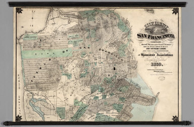
Author
Goddard, George H.
Full Title
City and County of San Francisco. Compiled from U.S. Land and Coast Surveys from the Official Surveys of the City, The Outside Lands. The Tide Land Commission and the Homestead Associations by George H. Goddard C.E. 1869. Lithographed & Published by Britton & Rey, Corr. Commercial & Leidesdorff Sts. S. Entered ... 1869.
List No
7819.000
Note
Shows in tint the tidelands, homestead areas, parks, and cemeteries. There is property information and street layouts that appear to be unique to this map, compared to other San Francisco maps of the same period. Wall map mounted on linen with decorative black sticks at top and bottom.
Author
[Beasley, T.D., Taylor, Jas. T.]
Full Title
Oahu, Hawaiian Islands. Compiled from Maps of Government Surveys and other reliable sources. Drawn by T.D. Beasley under supervision of Jas. T. Taylor, M. Am. Soc. C.E. November, 1899. United States, Copyright by Jas. T. Taylor 1899. Lith. Britton & Rey, S.F., Cal.
List No
3707.000
Note
Detailed, large scale map of Oahu made the year of annexation by the U.S. Shows lots and plantation names, topography, and town layouts. In full color. Relief shown by hachures and spot heights. Printed on 2 sheets. David Rumsey Collection copy mounted as one sheet; belonged to Michael M. O'Shaughnessy (deduced from ms "Oahu, Hawaii" in his hand), the famous California engineer (see 1881 Oahu map - our 3706); imprint cropped off.
Author
Henkenius, J.C.
Full Title
Map of the City of Oakland and Surroundings. Compiled from Official and Private Surveys. by J.C. Henkenius. Published by Woodward and Gamble, Real Estate and General Agents, 902 Broadway, Oakland. 1888. Britton & Rey Lith., S.F. Cal. Entered...1887.
List No
6717.000
Note
Has a view in the upper right corner of Woodward and Gamble office building in Oakland, Ca.
Author
Goddard, George H. (George Henry), 1817-1906
Full Title
Birds eye view of the city of San Francisco and surrounding country. Drawn by George H. Goddard. Lith. Britton & Rey, S.F. Entered according to act of Congress in the year 1868 by Snow & May in the ... U.S. District Court for the Northern District of California.
List No
5682.000
Note
Col. lithographic view looking east over ocean beach to the city, with the East Bay and Sierra; Golden Gate at the lower left. Unnumbered key in lower margin. A separate numbered key was published as "Key to Snow & Roos view ..." "This is the first of the 'run' of large bird's-eyes looking to the east" -- Baird. David Rumsey Collection copy framed.
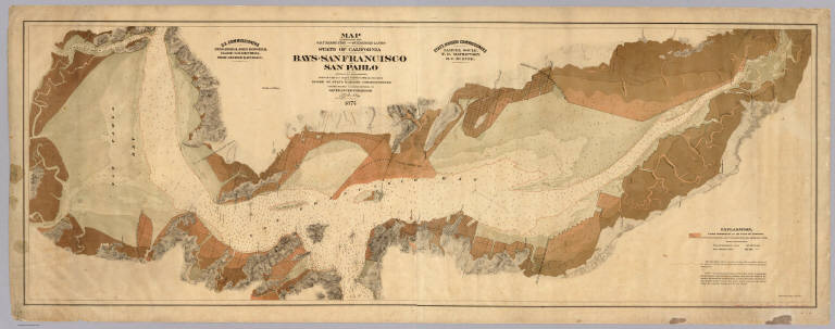
Author
[Arnold, T. J. (Thomas Jefferson), d. 1878, California. Board of State Harbor Commissioners for San Francisco Harbor]
Full Title
Map exhibiting the salt marsh, tide and submerged lands disposed of by the State of California in and adjacent to the bays of San Francisco and San Pablo and now subject to reclamation. Prepared from maps of the U.S. Coast Survey & official records by order of the Board of State Harbor Commissioners for the United States Commissioners on San Francisco Harbor. By T.J. Arnold, engineer of the sea wall. 1874. U.S. Commissioners Rear Admiral John Rodgers, Major G.H. Mendell, Prof. George Davidson. State Harbor Commissioners Samuel Soule, T.D. Mathewson, D.C. McRuer. Britton Rey & Co. Lith. S.F.
List No
4469.000
Note
This map shows the shoreline property sold by the state to private parties and "now subject to reclamation" (i.e. ready to be filled). The Vogdes map is probably later. An unusual view of the bay, with east at the top; shows water depths. With black top and bottom rollers. With full printed color in subtle tan shades. Printed on 2 sheets. David Rumsey copy mounted as one sheet, backed with cloth.
Author
King, M. G. (Malcolm G.)
Full Title
Map of Oakland, Alameda and Vicinity, Showing Plan of Streets as Opened and Proposed, Compiled from the most Reliable Public & Private Surveys, Published by M.G. King C.E.
List No
0409.000
Note
Earlier than other Phillips Oakland maps. This may be the first wall map of Oakland. It is the first large scale map of the Oakland/Alameda area in Vogdes.
Author
San Francisco Board of Supervisors
Full Title
Map Of The Outside Lands Of The City And County Of San Francisco Showing Reservations Selected for Public Purposes, under the Provisions of Order No. 800 ... Litho. Britton & Rey.
List No
0873.000
Note
Date estimated. Chas. H. Stanyan, A.J. Shrader, Beverly Cole, Chas. Clayton and Monroe Ashbury were the members of the Committee on Outside Lands of the Board of Supervisors which published this map. Many of the streets in the Haight Ashbury district were named after the members of the Committee on Outside Lands - these streets appear on this map. Includes key structures. Also see San Francisco Public Library's colored copy, our Pub List No. 5851.000.
Author
California Development Board
Full Title
Geographical, Topographical, State Highway And Railroad Map Of California. Published By California Development Board 1914 ... Copyrighted 1914 California Development Board. Britton & Rey, Lithographers, Inc., S.F. (inset) Land area of California ...
List No
10275.000
Note
Printed in full color. Includes: California Steamship Lines, and statement about California Development Board. Updates railroads from the 1914 issue (see our 5311.000).
Author
City Land Association
Full Title
Map of the Property of the City Land Association, Incorporated under the Laws of the State of California.
List No
12386.000
Note
Date estimated.
Author
Britton & Rey
Full Title
(Covers to) 1906 Britton & Rey's map of Greater San Francisco : Showing Burned District. Copyright by Britton & Rey 1906. Published by Britton & Rey Lithographers, San Francisco, California.
List No
13515.001
Author
Britton & Rey
Full Title
1906 Britton & Rey's map of Greater San Francisco : Showing Burned District. Copyright by Britton & Rey 1906. Published by Britton & Rey Lithographers, San Francisco, California.
List No
13515.002
Author
Williamson, R.S.
Full Title
Map of Parts of California, Nevada, Oregon And Idaho Territory, Showing the Routes to the Humboldt And Reese River Mines, Surproise Valley, Owyhee Mines, Idaho, etc. etc. Compiled from the latest Information and comprising the Results of Explorations ... By Bvt. Lieut. Col. R.S. Williamson, U.S.A. Maj. Of Engrs. John D. Hoffmann, C.E. & Topographer, In 1865, Lieut. W.H. Heuer, U.S. Engr. In 1866, U.S. Engineers Office, San Francisco, 1866. Published with Official Consent by Britton & Rey, San Francisco. ... (Reproduction).
List No
2115.000
Note
1 map on 4 sheets. Photo reproduction of photo reproduction. Original in LOC. First published map to show good detail of the Owyhee country and the proposed road from Silver City to Ft. McDermid via three forks of the Owyhee. Scale 12 Miles to One inch. Relief shown by hachures. See Wheat 1160.
Author
California. State Earthquake Investigation Commission
Full Title
Map of the city of San Francisco showing the streets and the burnt area, 1906. Earthquake Investigation Commission. Britton & Rey, engravers, San Francisco. (Carnegie Institution of Washington. 1908)
List No
2130.020
Note
Color. Shows block numbers, tracts, railroads, original shoreline, etc.
Author
[Britton & Rey, De Pue & Company]
Full Title
Pioneers of the Sacramento Valley. John R. Wolfskill, William Gordon, Jonas Spect, Stephen Cooper, S.U. Chase. De Pue & Co. Pub., S.F. Britton & Rey, Litho., S.F. (1879)
List No
2146.019
Note
Five lithographed portraits on 1 sheet.
Author
[Britton & Rey, De Pue & Company, Wyttenbach, Emanuel, fl. 1877-1895]
Full Title
Pioneers of Yolo Co., Cal. Chas. F. Reed, J.D. Stephens, G.D. Stephens, F.S. Freeman, Chas. Coil, Geo. D. Fiske, D.Q. Adams. (Drawn by) E. Wyttenbach. De Pue & Co. Pub., S.F. Britton & Rey, Lith., S.F. (1879)
List No
2146.024
Note
Seven lithographed portraits on 1 sheet.
Author
[Britton & Rey, De Pue & Company, Wyttenbach, Emanuel, fl. 1877-1895]
Full Title
J.W. Freeman, J.W. Aldrich, P.G. Everett, James Moore 1849, F.J. Barnes, I.R. Loranger, R.L. Beamer 1849. (Drawn by) E. W(yttenbach). De Pue & Co. Pub., S.F. Britton & Rey, Lith., S.F. (1879)
List No
2146.030
Note
Seven lithographed portraits on 1 sheet.
Author
[Britton & Rey, De Pue & Company]
Full Title
J.P. Bullock, A.W. Gable, H.C. Gable, J. Craig, H.P. Merritt, F. Bullard, R.H. Beamer. De Pue & Co. Pub., S.F. Britton & Rey, Lith., S.F. (1879)
List No
2146.035
Note
Seven lithographed portraits on 1 sheet.
Author
[Britton & Rey, De Pue & Company, Wyttenbach, Emanuel, fl. 1877-1895]
Full Title
Geo. H. Jackson, M.D., Thos. Ross, M.D.C.M., E.L. Parramore, M.D., A. Strong, M.D., Thornton Craig, M.D.C.M., L.B. Holmes, D.D.S., W.J. Prather. (Drawn by) E. Wyttenbach. De Pue & Co. Pub., S.F. Britton & Rey, Lith., S.F. (1879)
List No
2146.041
Note
Seven lithographed portraits on 1 sheet.
Author
[Britton & Rey, De Pue & Company, Wyttenbach, Emanuel, fl. 1877-1895]
Full Title
Prof. A.M. Elston, Joseph Griffin, Mrs. Joseph Griffin, John R. Briggs. (Drawn by) E. Wyttenbach. De Pue & Co. Pub., S.F. Britton & Rey, Litho., S.F. (1879)
List No
2146.049
Note
Four lithographed portraits on 1 sheet.
Author
[Britton & Rey, De Pue & Company]
Full Title
Residence and farm of Benjamin Ely embracing 1800 acres, 6 miles east from Winters, Yolo Co., Cal. Residence and farm of Joseph Griffin embracing 480 acres, 5 miles north east from Winters, Yolo Co., Cal. De Pue & Co. Pub., S.F. Britton & Rey, Litho., S.F. (1879)
List No
2146.050
Note
Two lithographed drawings on 1 sheet showing buildings, windmills, carriages, wagons, farm machinery, farm animals, human figures, dogs, blacksmith shop, etc.
Author
[Britton & Rey, De Pue & Company]
Full Title
Jno. W. Rhodes, S.N. Mering, J.H. Harlan, D.N. Hershey, W.W. Theobalds, Wm. Saunders, D.M. Burns. De Pue & Co. Pub., S.F. Britton & Rey, Litho., S.F. (1879)
List No
2146.053
Note
Seven lithographed portraits on 1 sheet.
Author
[Britton & Rey, De Pue & Company, Wyttenbach, Emanuel, fl. 1877-1895]
Full Title
P.S. Chiles, J.F. Chiles, Mrs. P.S. Chiles, W.D. Chiles. (Drawn by) E. Wyttenbach. De Pue & Co. Pub., S.F. Britton & Rey, Lith., S.F. (1879)
List No
2146.056
Note
Four lithographed portraits on 1 sheet.
Author
[Britton & Rey, De Pue & Company]
Full Title
Farm of Jno. M. Rhodes, embracing 1,400 acres and Capay Valley, looking north. Residence and farm of Hon. J.H. Harlan, embracing 480 acres, 5 miles S.W. from Woodland, Yolo Co., Cal. De Pue & Co. Pub., S.F. Lith. Britton & Rey, S.F. (1879)
List No
2146.061
Note
Two lithographed drawings on 1 sheet showing buildings, windmill, carriages, wagons, farm animals, human figures, etc.
Author
[Britton & Rey, De Pue & Company, Wyttenbach, Emanuel, fl. 1877-1895]
Full Title
W.C. Curtiss, Mrs. G.G. Todd, mother of Mrs. W.C. Curtiss, Mrs. W.C. Curtiss, Mattie E. Todd. (Drawn by) E. Wyttenbach. De Pue & Co. Pub., S.F. Britton & Rey, Lith., S.F. (1879)
List No
2146.062
Note
Four lithographed portraits on 1 sheet. Mattie Todd is on a tricycle, with dog.
Author
Trask, John B.
Full Title
Map Of The State Of California. Published by Britton & Rey Lithographers, Cor. of Commercial & Montgomery Sts. San Francisco. Drawn & Compiled from the most recent Surveys by J.B. Trask. Entered ... 1853 by Britton & Rey ... California.
List No
2674.000
Note
Shows great detail and accuracy. Wheat: "This is one of the best, as well as one of the rarest maps of the period." See also Trask's various Geological studies of California. Bancroft duplicate. Map is full color by county.
Author
Thompson, Thos. H.
Full Title
Map of the state of California, compiled expressly for Thos. H. Thompson, publisher, Tulare, Cal. Issued with the Fresno County atlas. Lith. Britton & Rey, S.F. (1891)
List No
2867.002
Note
Col. lithograph. Relief shown by hachures. Shows counties, townships, railroads, etc. Includes inset.
Author
Goddard, George H. (George Henry), 1817-1906
Full Title
Britton & Rey's Map Of The State Of California. Compiled from the U.S. Land & Coast Surveys, the several Military, Scientific & Rail Road Explorations, the State & County Boundary Surveys made under the Order of the Surveyor General of California, & from Private Surveys. By George H. Goddard, C.E. Completed with Additions & Corrections up to the day of publication from the U.S. Land Office & other reliable sources. Lithy. Of Britton & Rey, Montgomery St. Cor. Commercial, S.F. Entered ... 1857 by Britton & Rey ... California. Engraved by H. Steinegger.
List No
2901.000
Note
1st edition. Wheat: "This map, a beautiful example of the cartographer's art, is unfortunately rare and little-known...it was by far the most accurate and complete map of California and of its gold regions which had as yet been published." This copy was issued as a wall map, but it has been nicely restored, varnish removed, rebacked on paper without the rollers. The other examples I am aware of were all pocket maps. See Shumate essay on Goddard. A second edition, reduced in size, was published in 1858, and a third edition was published in 1860 (see WH copies). Map is unvarnished and without rollers. Outline color by county with a full color wash.
Author
Weber, C.F.
Full Title
(Covers to) Weber's Township And County Map Of California And Nevada Compiled From The Latest Official Data. Published By C.F. Weber & Co. San Francisco And Los Angeles California. Copyright, 1910, By C.F. Weber & Co. Photo-Lith. Britton & Rey.
List No
3668.001
Note
Many changes from the 1904 edition, in Southern Nevada and Southern California particularly, probably from the mining activities in those areas. Includes a 29 page index. Map has printed outline color by county, and is folded into red card board covers 17.5x12 with "Complete Indexed Map Of California And Nevada ... Published By C.F. Weber & Co. 365 Market Street, San Francisco, Cal. Corner Fremont Street. 210 N. Main Street, Los Angeles, Cal." printed on front in black.
Author
Weber, C.F.
Full Title
(Title Page to) Weber's Township And County Map Of California And Nevada Compiled From The Latest Official Data. Published By C.F. Weber & Co. San Francisco And Los Angeles California. Copyright, 1910, By C.F. Weber & Co. Photo-Lith. Britton & Rey.
List No
3668.002
Note
Many changes from the 1904 edition, in Southern Nevada and Southern California particularly, probably from the mining activities in those areas. Includes a 29 page index. Map has printed outline color by county, and is folded into red card board covers 17.5x12 with "Complete Indexed Map Of California And Nevada ... Published By C.F. Weber & Co. 365 Market Street, San Francisco, Cal. Corner Fremont Street. 210 N. Main Street, Los Angeles, Cal." printed on front in black.
Author
Weber, C.F.
Full Title
Weber's Township And County Map Of California And Nevada Compiled From The Latest Official Data. Published By C.F. Weber & Co. San Francisco And Los Angeles California. Copyright, 1910, By C.F. Weber & Co. Photo-Lith. Britton & Rey.
List No
3668.003
Note
Many changes from the 1904 edition, in Southern Nevada and Southern California particularly, probably from the mining activities in those areas. Includes a 29 page index. Map has printed outline color by county, and is folded into red card board covers 17.5x12 with "Complete Indexed Map Of California And Nevada ... Published By C.F. Weber & Co. 365 Market Street, San Francisco, Cal. Corner Fremont Street. 210 N. Main Street, Los Angeles, Cal." printed on front in black.
Author
Smith, F. E. (Frank Enos)
Full Title
(Covers to) Official map of Madera County, California 1914. Compiled from official records and surveys. Published by F.E. Smith, Co. Surveyor. Drawn by Irving Bacon, Deputy. Approved and declared the Official map of Madera County by order of the Board of Supervisors ... Copyright by F.E. Smith, 1914. Britton & Rey Lithographers Inc., S.F.
List No
3670A
Note
Orange card board covers with "Pocket official map of Madera County 1914. Compiled and published by F.E. Smith, County Surveyor. Drawn by Irving Bacon, Deputy County Surveyor, Madera California."
Author
Smith, F. E. (Frank Enos)
Full Title
Official map of Madera County, California 1914. Compiled from official records and surveys. Published by F.E. Smith, Co. Surveyor. Drawn by Irving Bacon, Deputy. Approved and declared the Official map of Madera County by order of the Board of Supervisors ... Copyright by F.E. Smith, 1914. Britton & Rey Lithographers Inc., S.F. (inset) City of Madera.
List No
3670.001
Note
Relief shown by hachures. Shows sections, landowners, etc. Inset map at (ca. 1:10,400) scale; shows block numbers, parcel boundaries; tracts, etc. Smith also made an 1898 wall map of Madera County. Without color; folded into orange card board covers 18 x 12.
Author
Grunskey, C.E.
Full Title
System Of Sewerage For The City And County Of San Francisco. Sewerage Districts Sewered On The Separate System Location Of Sewers And Of Pumping Stations. C.E. Grunsky, Civil Engineer in Charge, Marsden Manson, C.S. Tilton, Associate Engineers. October 29, 1899. Photo Lith. Britton & Rey, S.F.
List No
3683.000
Note
Show the entire city with contour intervals of 20 feet, new sewer systems indicated in red. Full color.
Author
[C.H. Street & Co., Immigration Association of California]
Full Title
(Covers to) Map of the state of California, compiled expressly for C.H. Street & Co., successors to the Immigration Association of California, 415 Montgomery St., San Francisco ... Lith. Britton & Rey, S.F. (1886?)
List No
3947A
Note
Self wrappers with title: Map of the state of California published by C.H. Street & Co. ... important. The immigration work to be continued on an enlarged scale and over a more extended field ...
Author
[C.H. Street & Co., Immigration Association of California]
Full Title
(Text Page to) Map of the state of California, compiled expressly for C.H. Street & Co., successors to the Immigration Association of California, 415 Montgomery St., San Francisco ... Lith. Britton & Rey, S.F. (1886?)
List No
3947B
Note
11, (1) p. folding pamphlet explaining immigration procedures, laws, climate, etc. Includes temperature and rainfall tables.
Author
[C.H. Street & Co., Immigration Association of California]
Full Title
Map of the state of California, compiled expressly for C.H. Street & Co., successors to the Immigration Association of California, 415 Montgomery St., San Francisco ... Lith. Britton & Rey, S.F. (1886?)
List No
3947.001
Note
Relief shown by hachures. Covers also Nevada. Shows townships, railroads, etc.
Author
Allardt, G. F.
Full Title
Sale map no. 11. Salt marsh and tide lands situate in the counties of Alameda & Contra Costa, state of California. To be sold at public auction by order of the Board of Tide Land Commissioners ... Greenbaum & Co. Auctioneers. Sale to commence Wednesday July 10th 1872, at 11 A.M. at the sales rooms of Greenbaum & Co. Nos. 115 & 117 Bush Street, San Francisco. R.P. Johnson, Edgar Briggs, C.M. Stratton, Board of Tide Land Commissioners. J.M. Currier, Secretary. G.F. Allardt, Chief Engineer. Lith. Britton & Rey S.F. (inset) Tide lands in Lake Merritt.
List No
3972.000
Note
This map is double the size of the usual tide land maps and shows the shore of the east bay from Oakland north to Point San Pablo. Cadastral map showing drainage, township and section lines, land ownership, ranchos, lot numbers, railroads, etc. Map is without color (for hand colored copy see our 4470). Printed on 2 sheets, mounted together.
Author
[Britton & Rey, San Francisco City]
Full Title
Map of the proposed line of Montgomery Avenue from the corner Washington and Montgomery Street to the corner of Union and Stockton Street. Length 2354 feet, Width 80 feet. Britton & Rey.
List No
4289.000
Note
Shows the plan for the first part of Montgomery Avenue, which later was renamed Columbus Avenue. Date is estimated - Langley's 1870 Directory map does not show this street, and Bancroft's and Langley's 1873 Maps of San Francisco do. Without color.
Author
Britton & Rey
Full Title
Map of San Francisco, Compiled from latest Surveys & containing all late extensions & Division of Wards. Published By Britton & Rey, San Francisco Cal.
List No
4333.000
Note
Letter sheet map showing the "Lately planket (sic) Streets" and the original shoreline. Streeter estimates the date by comparison with the Butler and Zakreski maps, which are earlier and later, respectively. With a vignette of an untitled building in the lower right corner. This copy was owned by the noted San Francisco collector Dr. Alexander Thomas Leonard, with his signature and notes on the verso of the board the map is mounted on. According to Sally Woodbridge the firm of of Page, Bacon & Co., which owned the building in the lower right corner was at the top of the banking heap in 1852; it was est. in 1849 as a branch of a St. Louis bank. In the financial panic of 1855 it suffered a disastrous run and was ruined along with many other banks.
Author
Langley, Henry G.
Full Title
Map of San Francisco from the latest surveys. Engraved expressly for the San Francisco Directory. 1873. Lith. Britton & Rey, S.F.
List No
4353.000
Note
Removed from the San Francisco Directory (not present here). Montgomery Avenue has been added in North Beach (when compared to the 1870 edition). Map is without color. Shows wards, railroads, street railroads, cemeteries, military reservations, etc.
Author
Allardt, G. F.
Full Title
Sale map no. 11. Salt marsh and tide lands situate in the counties of Alameda & Contra Costa, state of California. To be sold at public auction by order of the Board of Tide Land Commissioners ... Greenbaum & Co. Auctioneers. Sale to commence Wednesday July 10th 1872, at 11 A.M. at the sales rooms of Greenbaum & Co. Nos. 115 & 117 Bush Street, San Francisco. R.P. Johnson, Edgar Briggs, C.M. Stratton, Board of Tide Land Commissioners. J.M. Currier, Secretary. G.F. Allardt, Chief Engineer. Lith. Britton & Rey S.F. (inset) Tide lands in Lake Merritt.
List No
4470.000
Note
This map is double the size of the usual tide land maps and shows the shore of the east bay from Oakland north to Point San Pablo. Cadastral map showing drainage, township and section lines, land ownership, ranchos, lot numbers, railroads, etc. Hand colored (for uncolored copy see our 3972). Printed on 2 sheets, mounted together.
Author
Higley, Horace A.
Full Title
Official Map Of The County Of Alameda California Surveyed and compiled by Order of the Board of Supervisors. Horace A. Higley, County Surveyor. April - 1857. Lithy. of Britton & Rey, S.F.
List No
4600.000
Note
The first and earliest map of Alameda County listed by Vogdes and the second published county map of a California county, preceded only by San Francisco. The Bancroft Library catalog entry says "This is the oldest known map of Alameda County." Higley made several maps of local ranches and towns prior to making this county map. With brown top and bottom rollers and brown linen edging. With hand painted color by township.
Author
[McMurray, William, Layne, J.P.]
Full Title
(Covers to) Map Of White Pine District Lander Co. Nev. Showing The Principal Mines. Made For J.P. Layne Esq. By Wm. Mc.Murray, C.E. Septr. 1868. Lith. Britton & Rey, S.F. (with profile) Section Through A.B. Treasure Mountain.
List No
4880.001
Note
An early and unrecorded highly detailed map of White Pine mining towns and claims. Shows the towns of Hamilton, Treasure City and Shermantown. White Pine Mountain is shown with dense hachuring. There is a section through Treasure Mountain, and a view of Montecristo Mill. On the brown cloth covers 16x10 is a black paste down label reading "Murray's Map Of White Pine. Pacific Map Depot."
Author
[McMurray, William, Layne, J.P.]
Full Title
Map Of White Pine District Lander Co. Nev. Showing The Principal Mines. Made For J.P. Layne Esq. By Wm. Mc.Murray, C.E. Septr. 1868. Lith. Britton & Rey, S.F. (with profile) Section Through A.B. Treasure Mountain.
List No
4880.002
Note
An early and unrecorded highly detailed map of White Pine mining towns and claims. Shows the towns of Hamilton, Treasure City and Shermantown. White Pine Mountain is shown with dense hachuring. There is a section through Treasure Mountain, and a view of Montecristo Mill. On the brown cloth covers 16x10 is a black paste down label reading "Murray's Map Of White Pine. Pacific Map Depot."
Author
California Pacific Railroad
Full Title
Map Showing California Pacific Rail Road Extension And California Pacific Rail Road With Their Connections. 1869. Steam Litho. Britton & Rey, S.F.
List No
5287.000
Note
Map showing progress of California Pacific Rail Road project in color. Includes Table of Distances. Relief shown by hachures.
Author
California Development Board
Full Title
Geographical, Topographical, State Highway And Railroad Map Of California. Published By California Development Board 1914 ... Copyrighted 1914 California Development Board. Britton & Rey, Lithographers, Inc., S.F. (inset) Land area of California ...
List No
5311.000
Note
Printed in full color. Includes: California Steamship Lines, and statement about California Development Board.
|