|
Author
[Berghaus, Heinrich, Berghaus, Hermann]
Full Title
(Title Page to) Berghaus' Physikalischer Atlas. (Begrundet 1836 durch Heinrich Berghaus). Dritte Ausgabe. 75 Karten in sieben Abteilungen enthaltend 514 Darstellungen uber Geologie, Hydrographie, Meteorologie, Erdmagnetismus, Pflanzenverbreitung, Tierverbreitung und Volkerkunde. Vollstandig neu bearbeitet und unter Mitwirkung von Dr. Oscar Drude ... Dr. Georg Gerland ... Dr. Julius Hann ... Dr. William Marshall ... Dr. Georg Neumayer ... Dr. Karl v. Zittel ... herausgegeben von Prof. Dr. Herm. Berghaus. Gotha: Justus Perthes. 1892.
List No
4391.002
Note
New edition of Berghaus' Atlas in seven parts : I: Geologie, II: Hydrographie, III: Meteorologie, IV: Erdmagnetismus, V: Pflanzenverbreitung, VI: Tierverbreitung, VII: Volkerkunde, with individual title pages dated variously 1887, 1891, and 1892, indicating that each was also published separately (see our copy of Atlas der Geologie). This is a new edition, updated by Berghaus' son, with all the maps completely redone, and still, amazingly, hand colored in a style equal to the first edition. There are actually only 74 maps, No. 7/8 are combined in one plate. Atlas is bound in half leather black cloth covered boards with "Berghaus' Physikal. Atlas." stamped in gilt on the front cover and spine.
Author
[Berghaus, Heinrich, Berghaus, Hermann, Luddecke, R., Hess, O.]
Full Title
Hohen und Tiefen. Entworfen u. bearbeitet v. Dr. R. Luddecke. Gest v. O. Hess. Ausgabe 1891. Gotha: Justus Perthes. (On upper margin) I. Abt. Geologie No. I. Berghaus' physikal atlas No.1. (to Accompany) Berghaus' Physikalischer Atlas. (Begrundet 1836 durch Heinrich Berghaus) ... Gotha: Justus Perthes. 1892. (insets) Erdprofile, im gleichen Langen- und Hohenmaassstab (aus Ferdinand Lingg's Erdprofil). (with) Grosste u. mittlere Hohen und Tiefen der westlichen Erdhalfte. (with) Grosste u. mittlere Hohen und Tiefen der ostlichen Erdhalfte.
List No
4391.012
Note
Color lithograph double hemisphere map, with inset maps and charts. Includes Comparative View of the Heights of the Principal Mountains in the World. Relief shown by contours. Depth shown by gradient tints.
Author
[Berghaus, Heinrich, Berghaus, Hermann, Schmidt, C., Risch, M.]
Full Title
Tieflander. Entw. v. Herm. Berghaus 1883, Ausg. 1887. Gez. v. C. Schmidt u. M. Risch. Gotha: Justus Perthes. (On upper margin) I. Abt. Geologie No. II. Berghaus' physikal atlas No. 2. (to Accompany) Berghaus' Physikalischer Atlas. (Begrundet 1836 durch Heinrich Berghaus) ... Gotha: Justus Perthes. 1892.
List No
4391.013
Note
14 color lithograph maps with insets on 1 sheet. Includes: Die Heutigen Niederlande, with insets: Niederlande in 1. Jahrhundert -- Niederlande in X. Jahrhundert, at scale of 1: 6,000,000. Fen District -- El-Ghor oder das Jordan Thal -- Kaspisches Tiefland und Manytsch Niederrung -- Natron-Seen -- El Fajum -- Nordrand der Libyschen Wuste -- Das Todte Thal -- Colorado-Wuste -- Nordrand der Algerischen Sahara -- Goban n. Paulistischke -- Sud-Australische Seen -- Tiefland Asale -- Assal-See. Relief shown by contours and spot heights. Depth shown by gradient tints and soundings. Prime meridian is Greenwich.
Author
[Berghaus, Heinrich, Berghaus, Hermann, Schmidt, C., Risch, M.]
Full Title
Thatigkeit des Erdinnern. Vulkane und Strand-veranderungen in Mollweide's flachenrechter Erdansicht. Entw. v. Herm. Berghaus 1885, Ausg. 1888. Gotha: Justus Perthes. (On upper margin) I. Abt. Geologie No. III. Berghaus' physikal atlas No. 3. (to Accompany) Berghaus' Physikalischer Atlas. (Begrundet 1836 durch Heinrich Berghaus) ... Gotha: Justus Perthes. 1892. (8 insets).
List No
4391.014
Note
Color lithograph maps with 8 insets and 1 profile view. Relief shown by contours and spot heights. Depth shown by gradient tints and soundings. Prime meridian is Greenwich. Insets: Jan Mayer, nordlichster Vulkan -- Erdbeben-Gebiete westliche -- Ostliche Erdbeben-Gebiete -- Insel Augustin (Tschernabura) -- Stromboli (Liparische Inseln) thatigster Vulkan -- Santorin (Kykladen) -- Sunda Strasse -- Tengger-Gebirge & Semiru. Includes legend and explanation.
Author
[Berghaus, Heinrich, Berghaus, Hermann, Rohrbach, C., Luddecke, R.]
Full Title
Grund und Boden. Bearbeitet v. Dr. C. Rohrbach, Red. v. Dr. R. Luddecke. Ausgabe 1892. Gotha: Justus Perthes. (On upper margin) I. Abt. Geologie No. IV. Berghaus' physikal atlas No. 4. (to Accompany) Berghaus' Physikalischer Atlas. (Begrundet 1836 durch Heinrich Berghaus) ... Gotha: Justus Perthes. 1892. (7 insets).
List No
4391.015
Note
Color lithograph double hemisphere map with 7 insets. Depth shown by gradient tints and soundings. Insets: Dunen des Nefud -- Sudliche Erdhalfte, Niederschlage im Juli -- Niederschlage im Januar, Nordliche Erdhalfte -- Dunen in Central Australien -- Dunen des Tharr -- Ostliche Areg -- Trockene Niederschlage. Includes legend and explanation.
Author
[Berghaus, Heinrich, Berghaus, Hermann]
Full Title
Eisverbreitung, einst und jetzt. Polar Ansicht der Erde in Lambert's flachenrechter Azimuthal-projection. Entw. v. Herm. Berghaus 1884, Ausg. 1886. Gotha: Justus Perthes. (On upper margin) I. Abt. Geologie No. V. Berghaus' physikal atlas No. 5. (to Accompany) Berghaus' Physikalischer Atlas. (Begrundet 1836 durch Heinrich Berghaus) ... Gotha: Justus Perthes. 1892. (7 insets).
List No
4391.016
Note
Color lithograph double hemisphere map with 7 insets. Depth shown by gradient tints, isoline and soundings. Relief shown by hachures. Insets: Der Rhein-Gletscher nach A. Favre -- Der Rhone Gletscher nach A. Falsan -- Seen-Gebiet in Nord-Amerika nach Chamberlin und Wright -- Die Europaischen Alpen -- Iseo-Gletscher nach Stroppani -- Der Loisach- und Inn-Gletscher n. Penck & Bayberger -- Die Sudlichen Alpen (Neu-Seeland) nach J. v. Haast. Includes legend and explanation.
Author
[Berghaus, Heinrich, Berghaus, Hermann, Risch, M., Hess, O., Kogel, F.]
Full Title
Gletscherkarte. Entw. v. Herm. Berghaus 1885, Ausg. 1888. Gez. v. M. Risch. Gest. v. O. Hess, Berge v. F. Kogel. Gotha: Justus Perthes. (On upper margin) I. Abt. Geologie No. VI. Berghaus' physikal atlas No. 6. (to Accompany) Berghaus' Physikalischer Atlas. (Begrundet 1836 durch Heinrich Berghaus) ... Gotha: Justus Perthes. 1892.
List No
4391.017
Note
21 color lithograph maps on 1 sheet. Relief shown by hachures and spot heights. Insets: Inlandeis des Frederickshaab-Glets chers nach J.A.D. Jensen -- Gronlandisches Binnen-Eis -- Justedals Bra -- Jotun Fjeld -- Berner Oberland -- Gletscher des Halbinsel Kenai (Alaska) -- Aus dem sudlichen Gronland n. G. Holm -- Gletscher des Mount Tacoma (nach dem Northern Transcontinental Survey) von Bailey Willis -- Gletscher des Mount Shasta (nach dem U.S. Geological Survey) von J.S. Diller -- Gletscher von Oisans -- Nevado de Chillan nach A. Philippi -- San Rafael Gletscher -- Oetzthaler Gruppe -- Glockner Gruppe -- Ross-Gletscher (Sud-Georgien) -- Gletscher des Adai Choch (Kaukasus) nach M. v. Dechy -- Hohe von Schneegrenzen und Gletscher-Enden -- Gletscher des Kasbek -- Serafschan Gletscher (Turkestan) nach I.W. Muschketow -- Neuseelandische Alpen nach R. v. Lendenfield.
Author
[Berghaus, Heinrich, Johnston, Alexander Keith, 1804-1871]
Full Title
The river systems of Asia & Europe, showing the boundaries and comparative extent of the river basins & the oceans to which they contribute their waters. Extended from the original designs of Professor Berghaus, Berlin. By A.K. Johnston, F.R.G.S. Engraved by W. & A.K. Johnston. William Blackwood & Sons, Edinburgh & London. (1856)
List No
0372.017
Note
Hand col. lithograph. Includes profile: Comparative view of the fall of the rivers Volga, Ganges, Danube, Elbe, Rhine, Rhone & Clyde with the positions of some of the most remarkable lakes above & below the level of the sea. "Hydrology no. 5."
Author
[Berghaus, Heinrich, Johnston, Alexander Keith, 1804-1871]
Full Title
The river systems of America, extended from the designs of Professor Berghaus, with additions of detailed maps of some of the principal hydrographical phenomena of the New World by A.K. Johnston, F.R.G.S. Corrected to 1855. Engraved by W. & A.K. Johnston. William Blackwood & Sons, Edinburgh & London. (1856)
List No
0372.018
Note
Two hand col. maps on 1 sheet. Inset maps: Sketch of the Niagara River showing the position of the Falls -- Delta of the Mississippi -- Map of the bifurcation of the Orinoco, or the natural junction of the Orinoco & Maranon rivers by the Casiquiare surveyed by A. von Humboldt. Scale 1:4,000,000. "Hydrology no. 6."
Author
Berghaus, Heinrich
Full Title
(Covers to Vol. 1) Dr. Heinrich Berghaus' Physikalischer Atlas oder Sammlung von Karten, auf denen die hauptsachlichsten Erscheinungen der anorganischen und organischen Natur nach ihrer geographischen Verbreitung und Vertheilung bildlich dargestellt sind ... 1845. Verlag von Justus Perthes in Gotha ... 1848 ...
List No
2515A
Author
Berghaus, Heinrich
Full Title
(Title Page to Vol. 1) Dr. Heinrich Berghaus' Physikalischer Atlas oder Sammlung von Karten, auf denen die hauptsachlichsten Erscheinungen der anorganischen und organischen Natur nach ihrer geographischen Verbreitung und Vertheilung bildlich dargestellt sind ... 1845. Verlag von Justus Perthes in Gotha ... 1848 ...
List No
2515B
Note
Of the 90 plates, 75 are maps. 1st ed 2nd state,1845/1848 on titles, 1849 on some maps in volume one. 1st edition, 1st state was 1845/1848, with no maps dated later than 1848 (rare - WH). Second edition 1852 (see our copy). This is considered the first comprehensive physical atlas of the world. Robinson: "Berghaus' Physikalischer Atlas was a monumental achievement, bringing together an enormous amount of information about the physical geography of the earth and encompassing many more subjects than had been treated in the numerous smaller atlases that had been produced since the 1820's." In two volumes, the first dated 1845, the second 1848. A.K. Johnston's Physical Atlas of 1848 was based on this work. Maps are hand painted in full and outline color. Atlas volumes are bound in green cloth covered boards stamped in gold with "Berghaus' Physik. Atlas 90 Karten. I Band." and "... II Band." for volumes I and II, respectively. The spines read "Berghaus. I." and "Berghaus. II."
Author
Berghaus, Heinrich
Full Title
(Index Page to Vol. 1) Dr. Heinrich Berghaus' Physikalischer Atlas oder Sammlung von Karten, auf denen die hauptsachlichsten Erscheinungen der anorganischen und organischen Natur nach ihrer geographischen Verbreitung und Vertheilung bildlich dargestellt sind ... 1845. Verlag von Justus Perthes in Gotha ... 1848 ...
List No
2515C
Author
[Berghaus, Heinrich, Humboldt, Alexander von, 1769-1859]
Full Title
Alexander von Humboldt's System Der Isotherm-Kurven, in Merkator's Projection. 1ste. Abtheilung: Meteorologie No. 1. Gezeichnet v. Bar u. F. Schelle, nach Berghaus' Entwurf. Gestochen bei Madel II. Gotha, J. Perthes. 1838. Zweite Auflage. 1849.
List No
2515.001
Note
Map in partial color showing isotherm lines throughout the world. Explorers and dates of exploration are also noted in both hemispheres.
Author
Berghaus, Heinrich
Full Title
Die Isothermkurven Der Nordlichen Halbkugel. 1ste. Abtheilung: Meteorologie No. 2. Gezeichnet v. Bar, Berghaus, u. Schelle. In Potsdam Gestochen von K. Kolbe. Gotha, J. Perthes. 1838.
List No
2515.002
Note
In color. Polar projection showing the isothermal lines around the North Pole and south to the equator. Drawings of the major mountain ranges and peaks included at the bottom of the map.
Author
Berghaus, Heinrich
Full Title
Karte Von Europa. Zur Ubersicht der Warme-Verbreitung in diesem Erdtheile. 1ste. Abtheilung: Meteorologie No. 3. Gez. v. Bar u. Berghaus. Gest. v. K. Kolbe. Gotha, J. Perthes. 1837.
List No
2515.003
Note
In outline color. Europe shown with isothermal lines.
Author
Berghaus, Heinrich
Full Title
Die Hauptmomente Der Temperatur Auf Dem Ganzen Erboden, gegrundet auf die Beobachtungen an 307 Orten. Thermometer-Centigrade. 1ste Abtheilung: Meteorologie No. 4.
List No
2515D
Note
Four pages of charts showing the temperatures in the four seasons throughout a large number of places in the world.
Author
Berghaus, Heinrich
Full Title
Graphische Darstellung des Ganges der Temperatur Innerhalb Der Tagl. Und Jahrl. Periode in Allen Zonen. 1ste. Abtheilung: Meteorologie No. 5. Potsdam, in der Geographischen Kunstschule. Gotha, bei Justus Perthes. 1839. Zweite Auflage. 1849.
List No
2515.004
Note
Six charts related to temperature throughout the world.
Author
Berghaus, Heinrich
Full Title
Ubersicht Der Mittleren Barometerstande Am Meere Und Der Oscillationen Des Luftdrucks. 1ste. Abtheilung: Meteorologie No. 6. Gest. v. W. Barns. Gotha, Justus Perthes. 1839.
List No
2515.005
Note
Map showing the average barometric pressure at sea and the oscillation of the air pressure. In outline color.
Author
Berghaus, Heinrich
Full Title
Windkarte der Erde. 1ste. Abtheilung: Meteorologie No. 7. Gezeichnet in der geographischen Kunstschule zu Potsdam. Gestochen von Edler. Gotha, Justus Perthes. 1840.
List No
2515.006
Note
A map of the world showing the tradewinds. Five inset maps show specialized wind data. In color.
Author
Berghaus, Heinrich
Full Title
Die Luftstromungen auf dem Nordatlantishcen Ocean, im Westlichen Gebiet der Alten und im Ostlichen Theil der Neuen Welt. 1ste. Abtheilung: Meteorologie No. 8. Gezeichnet v. F. Schelle, nach Berghaus' Entwurf. Gestochen v. Wilh. Jattnig in Berlin. Gotha, Justus Perthes. 1838. Zweite Auflage. 1849. Bearbeitet in der Geographischen Kunstschule zu Potsdam.
List No
2515.007
Note
North Atlantic air flow patterns. Without color.
Author
Berghaus, Heinrich
Full Title
Hyetographische Karte der Erde. 1ste. Abtheilung Meteorologie No. 9. Gez. u. gest. in der geogr. Kunstschule zu Potsdam. Gotha, bei J. Perthes. 1841.
List No
2515.008
Note
In color. Shows precipitation throughout the world.
Author
Berghaus, Heinrich
Full Title
Karte von Europa Zur Ubersicht der Regen Verhaltnisse in diesem Erdtheile. 1ste. Abtheilung Meteorologie No. 10. Potsdam, gezeichnet in der geographischen Kunstschule. Gestochen von E.G. Edler. Gotha, J. Perthes. 1841. Zweite Auflage. 1849.
List No
2515.009
Note
Map showing rain patterns throughout Europe in outline color.
Author
Berghaus, Heinrich
Full Title
Ubersicht der Meteorologischen Stationen in Deutschland, der Schweiz, den Niederlanden, &c&c&c. 1ste. Abtheilung Meteorologie No. 11. Potsdam, gez. u. gest. in der geograph. Kunstschule. 2te Auflage, Gotha, bei J. Perthes 1849.
List No
2515.010
Note
Map showing the meterological stations throughout Central Europe. In outline color.
Author
Berghaus, Heinrich
Full Title
Summarische Ubersicht der auf der ganzen Erde angestellten hyetometrischen Beobachtungen. 1ste Abtheilung: Meteorologie No. 12. Gotha, Justus Perthes. 1841.
List No
2515E
Note
Rain data from all around the world.
Author
Berghaus, Heinrich
Full Title
Versuch Einer Ubersicht Der Geographischen Verbreitung Der Gewitter. 1ste Abth: Meteorologie No. 13. Potsdam, in der geogr. Kunstschule gest v. E. Reyher. Gotha, J. Perthes. 1849. Zweite Auflage.
List No
2515.011
Note
Page includes two maps entitled "Europa im Allgemeinen" and "Bohmen im Besondern." In outline color. Maps show the extension and frequency of thunderstorms.
Author
Berghaus, Heinrich
Full Title
Versuch Einer Karte Zur †bersicht Der Fluthwellen, Von Dem Rev. W. Whewell, M.A., F.R.S., In Cambridge. 2te Abtheilung: Hydrographie, No. 1. Gezeichnet von F. Schelle. Gest. v. Edler. Gotha, J. Perthes, 1838.
List No
2515.012
Note
With some color on smaller maps.
Author
Berghaus, Heinrich
Full Title
Karte von dem Deutschen Meere und den Angranzenden Theilen Des Atlantischen Oceans. Zur Ubersicht der Fluthwellen und der Beschaffenheit des Seebodens. Nach Whewell und Lubbock. 2te Abtheilung: Hydrographie, No. 2. Gezeichnet von F. Schelle. Gestochen bei Madel II. Gotha, J. Perthes, 1838.
List No
2515.013
Note
In outline color. Map shows the tidal patterns around the United Kingdom and the French coast. Inset map details the soundings across the English Channel.
Author
Berghaus, Heinrich
Full Title
Karte vom Atlantischen Ocean; Zur Ubersicht der Stromungen und Handelsstrassen, der Warme-Verbreitung, des Seebodens, &c., &c. 2te Abtheilung: Hydrographie, No. 3. Gezeichnet von J.C. Bar und dem Verfasser. Gestochen von Johann Carl Ausfeld. Gotha, Justus Perthes. 1837.
List No
2515.014
Note
Map shown with an inset map of the southern tip of South America. In outline color. The map shows the currents, trade routes, and sea temperatures across the Atlantic Ocean.
Author
Berghaus, Heinrich
Full Title
Karte vom Grossen Ocean, (Mare Pacifico); Zur Ubersicht der Stromungen, Temperatur und Handelsstrassen. Gegrundet auf die Beobachtungen, welche seit Magalhaens' Zeit bis auf die Preussischen Weltreisen gemacht sind. 2te Abtheilung: Hydrographie, No. 4. Gez. von I.C. Bar und dem Verfasser. gest. v. E.G. Edler. Gotha, Justus Perthes. 1837.
List No
2515.015
Note
The Pacific Ocean shown with currents, sea temperatures, and trade routes. Observations based up the voyages from Magellan to Preuss. In outline color.
Author
Berghaus, Heinrich
Full Title
Physikalische Karte vom Indischen Meere. 2te Abtheilung: Hydrographie, No. 5. Potsdam, in der geograph. Kunstschule. Bei J. Perthes in Gotha. 1840. Gestochen bei Madel II.
List No
2515.016
Note
Map of the Indian Ocean showing sea temperatures, trade routes, and air currents in outline color.
Author
Berghaus, Heinrich
Full Title
Der Warme Meeresstrom Des Atlantischen und Der Kalte Strom Des Grossen Oceans in Parallele nach geographischer Lage und Ausdehnung Dargestellt. Edler sc. Gotha. 2te Abtheilung: Hydrographie, No. 6. Potsdam, gezeichnet in der geographischen Kunstschule. 1840. Westliche Lange von Paris. Gotha, bei J. Perthes. 1841.
List No
2515.017
Note
The map shows the warm Atlantic current and the cold Pacific currents, showing their geographical location and size. In outline color.
Author
Berghaus, Heinrich
Full Title
Asia-Europa; in Beziehung auf das Fliessende, und seine Vertheilung in Stromgebiete. 2te Abtheilung: Hydrographie, No. 7. Potsdam, gez. u. gest. in der geograph. Kunstschule. Gotha bei J. Perthes. 1841.
List No
2515.018
Note
Map shows the drainage into the oceans and seas of the different areas in Europe and Asia. In outline color.
Author
Berghaus, Heinrich
Full Title
Stromgebiete Der Neuen Welt. 2te Abtheilung: Hydrographie, No. 8. Potsdam, gez. u. gest. in der geogr. Kunstschule. Gotha, bei Justus Perthes. 1842.
List No
2515.019
Note
Maps of North America and South America showing the draining basins of each continent. In full color. An accompanying table lists the lenghts of the longest rivers around the world.
Author
Berghaus, Heinrich
Full Title
Ubersicht der bekannteren Gabeltheilungen des Stromenden Wassers. 2te Abtheilung: Hydrographie, No. 9. Potsdam, bearbeitet in der geographischen Kunstschule. Gotha, J. Perthes. 1839.
List No
2515.020
Note
Nine uncolored maps showing the more well-known rivers of the world.
Author
Berghaus, Heinrich
Full Title
Vermischtes zur Hydrographie: Schwankungen des Ostsee Standes, Strom Neigungen, &c. &c. 2te Abtheilung: Hydrographie, No. 10. Potsdam, gez. u. gest. in der geogr. Kunstschule. Gotha, bei Justus Perthes. 1843.
List No
2515.021
Note
Numerous charts showing miscellaneous hydrographic information about the rivers of Europe.
Author
Berghaus, Heinrich
Full Title
Hydro-Historische Darstellung vom Zustande der Elbe in dem Halbjahrhundert 1731-1780. 2te Abtheilung: Hydrographie, No. 11. Nach Berghaus' Entwurf gez. von G. Haase. Gestochen von K. Kolbe. Gotha, J. Perthes. 1837.
List No
2515.022
Note
Historical chart of the Elbe River including average and high water level, as well as the ice levels.
Author
Berghaus, Heinrich
Full Title
Hydro-Historische Ubersicht vom Zustande der Elbe in dem Halbjahrhundert 1781-1830. 2te Abtheilung: Hydrographie, No. 12. Nach Berghaus' Entwurf gez. von G. Haase. Gestochen von K. Kolbe. Gotha, J. Perthes. 1837.
List No
2515.023
Note
Historical chart of the Elbe River including average and high water level, as well as the ice levels.
Author
Berghaus, Heinrich
Full Title
Hydro-Historische Ubersicht vom Zustande der Oder in dem Halbjahrhundert 1781-1830. 2te Abtheilung: Hydrographie, No. 13. Nach Berghaus' Entwurf gez. von G. Haase. Gestochen von K. Kolbe. Gotha, J. Perthes. 1837.
List No
2515.024
Note
Historical chart of the Oder River including average and high water level, as well as the ice levels.
Author
Berghaus, Heinrich
Full Title
Vergleichende Ubersicht Vom Zustande Des Rheins, Der Weser, Der Elbe Und Oder, Wahrend Der Zehn Jahre Von 1831-1840. 2te Abtheilung: Hydrographie, No. 14. Gez. u. gest. in der geograph. Kunstschule zu Potsdam. Gotha bei Justus Perthes. 1841.
List No
2515.025
Note
A chart comparing four German rivers, the Rhine, Weser, Elbe and Oder.
Author
Berghaus, Heinrich
Full Title
Die Deutschen Strome Rhein, Elbe, Oder; nach ihrem Verhalten Innerhalb Eines Jahres; gegrundet auf die Beobachtungen der Pegel zu Emmerich, Koln, Magdeburg, Dresden, Kustrin. Nebst der Darstellung von dem Fahresstande dieser Strome seit 1728 &c. 2te Abtheilung: Hydrographie, No. 15. Entw.und gez. von H. Berghaus. Gest. von K. Kolbe. Gotha, J. Perthes. 1838.
List No
2515.026
Note
Statistical information about three large German rivers.
Author
Berghaus, Heinrich
Full Title
Hydrographisches Tableau Der Weser, Weichsel, Und Des Memelstroms. 2te Abtheilung: Hydrographie, No. 16. Potsdam, gez. u. gest. in der geograph. Kunstschule. Gotha bei Justus Perthes. 1842.
List No
2515.027
Note
Statistical information about three large German rivers.
Author
Berghaus, Heinrich
Full Title
Erdkarte zur Ubersicht Der Vertheilung des Starren und Flussigen, der Verschiedenheit der Oberflachen Gestaltung. Nebst Andeutungen zu Einer Arithmetisch-Geographischen Entwickelung der Wagerechten und Senkrechten Ausdehnungen. 3te Abtheilung: Geologie, No. 1. Gezeichnet v. F. Schelle. Gestochen v. Wilh. Jattnig in Berlin. Gotha, J. Perthes, 1839. Bearbeitet in der Geographischen Kunstschule zu Potsdam.
List No
2515.028
Note
Double hemisphere map in outline color. Shows both poles and is surrounded by copious statistical data about the size of the continents, height of the tallest mountains, etc.
Author
Berghaus, Heinrich
Full Title
Bergketten In Asien Und Europa. 3te Abtheilung: Geologie, No. 2. Potsdam, gez. u. gest. in der geogr. Kunstschule. Gotha, bei Justus Perthes, 1842.
List No
2515.029
Note
Map showing the mountain ranges in Asia and Europe. In outline color with inset maps of Java, Luzon, and Reguain (an island off the coast of Burma).
Author
Berghaus, Heinrich
Full Title
Europa's Haupt-Gebirgs Systeme. 3te Abtheilung: Geologie, No. 3. Gez. u. gest. in der geograph. Kunstschule zu Potsdam. Gotha bei Justus Perthes. 1842.
List No
2515.030
Note
Europe's mountain ranges are shown using a combination of contour lines and hachures. The lakes are in color with the remainder of the map in outline color.
Author
Berghaus, Heinrich
Full Title
Europa in Geologischer Beziehung nach den Hauptmassen der Gebirgs-Formationen. 3te Abtheilung: Geologie, No. 4. Gotha, bei J. Perthes. 1843.
List No
2515.031
Note
A geologic map of Europe showing active volcanoes, and the oldest and newest mountain ranges on the continent. In full color.
Author
Berghaus, Heinrich
Full Title
Karte von Sud-Amerika zur Ubersicht der Unebenheiten des Bodens. 3te Abtheilung: Geologie, No. 5. Potsdam, gez. u. gest. in der geogr. Kunstschule. Gotha, bei Justus Perthes, 1843.
List No
2515.032
Note
Map showing the topography of South America. Includes three inset maps: The southern tip of South America, the mountain region of Quito, Ecuador, and part of Bolivia. In outline color.
Author
[Berghaus, Heinrich, Humboldt, Alexander von, 1769-1859]
Full Title
Bergketten in Nord-Amerika. 3te Abtheilung: Geologie, No. 6. Potsdam, gez. u. gest. in der geogr. Kunstschule. Gotha, bei Justus Perthes, 1842.
List No
2515.033
Note
Map in outline color showing the mountain ranges and volcanoes in North and Central America. With two inset maps: Trinidad and a plan of the volcanoes in Jorullo (by Alexander von Humboldt). In the United States, Mts. Shasta, St. Helens, Hood, and Rainier are shown.
Author
Berghaus, Heinrich
Full Title
Die Vulkanischen Erscheinungen Der Atlen Welt, In Und Um Den Atlantischen Ocean. 3te Abtheilung: Geologie, No. 7. Potsdam, gestochen in der geographischen Kunstschule. Gotha, bei J. Perthes, 1839.
List No
2515.034
Note
Map shows the range of volcanic and earthquake activity throughout the world. In outline color are three different earthquake regions with dates of activity ranging from 1755-1838.
Author
Berghaus, Heinrich
Full Title
Specialia vom Vulkan Gurtel des Atlantischen Oceans. 3te Abtheilung: Geologie, No. 8. Gezeichnet von F. Schelle. Gestochen von Joh. Carl Ausfeld. Gotha, J. Perthes, 1839.
List No
2515.035
Note
Thirteen maps showing volcanic activity throughout the Atlantic and Mediterranean Oceans. Detailed outline colored maps are accompanied by drawings of exploding volcanoes, calderas, and volcanic mountain ranges.
Author
Berghaus, Heinrich
Full Title
Karte von dem Vulkan Gurtel und dem Central Gruppen des Grossen Oceans; nach Leopold v. Buch; von Berghaus. Potsdam, 16 Juli 1838. 3te Abtheilung: Geologie, No. 9. Gezeichnet von F. Schelle. In Potsdam Gestochen von K. Kolbe. Gotha, J. Perthes, 1838.
List No
2515.036
Note
Map of the Pacific Ocean showing volcanic and earthquake activity. Circled regions of activity include the Philippines and Central America. In outline color.
Author
Berghaus, Heinrich
Full Title
Die Vulkanreihe von Guatemala, die Landengen von Tehuantepec, Nicaragua und Panama, und die Central Vulkane der Sud See. 3te Abtheilung: Geologie, No. 10. Potsdam, gez. u. gest. in der geogr. Kunstschule. Gotha, bei J. Perthes, 1840.
List No
2515.037
Note
Maps in outline color. Main map is of Central America. Nine inset maps detail the volcanic regions of Central America and the islands in the Pacific Ocean and South Seas. Side views of Costa Rica, Guatemala, and the isthmus of Tehuantepec are included.
Author
Berghaus, Heinrich
Full Title
Idealer Durchschnitt eines Theils Der Erdrinde. Verfafst von Thomas Webster, F.G.S. &c. Die Pflanzen und Thiere nach der Auswahl und Anordnung des Dr. Buckland gezeichnet von Joseph Fischer. Potsdam, gestochen in der geographischen Kunstschule, die Figuren von J.C. Ausfeld. 3te Abtheilung: Geologie, No. 11. Gotha, J. Perthes, 1841.
List No
2515.038
Note
A full color "ideal" geologic cross section with a detailed key explaining all of the notations on the map. Above the section are numerous drawings of plants, animals, and sea life.
Author
Berghaus, Heinrich
Full Title
Geologische Karte von Deutschland und den anlieg. Landern nach des Bergmeister's H. Credner Zusamenstellung. 1843. 3te Abtheilung: Geologie, No. 12. Gotha, bei J. Perthes.
List No
2515.039
Note
A full color geologic map of Germany accompanied by two keys.
Author
Berghaus, Heinrich
Full Title
Spezial-Karte vom Riesen-Gebirge. 3te Abtheilung: Geologie, No. 13. Gezeichnet u. gestochen in der geogr. Kunstschule zu Potsdam. Gotha, J. Perthes, 1843.
List No
2515.040
Note
Geologic map of the Reisengebirge (or Krkonose, Karkonosze or Giant Mountains) in the Czech Republic and Poland.
Author
Berghaus, Heinrich
Full Title
Geologische Profile von Deutschland im Allgemeinen u. von Riesengebirge im Besondern; Sammt Einer Karte vom Tertiar Becken von Paris. 3te Abtheil: Geologie, No. 14. Gezeichnet von H. Credner. Gest. v. E.G. Edler. Gotha, bei J. Perthes, 1845.
List No
2515.041
Note
A full color geologic map of France and numerous full color geologic cross sections of Germany. A key is included.
Author
Berghaus, Heinrich
Full Title
Vermischtes zur Geologie. 3te Abtheilung: Geologie, No. 15. Potsdam, gez. u. gest. in der geogr. Kunstschule. Gotha, bei J. Perthes, 1844.
List No
2515.042
Note
Miscellaneous geological maps, charts, and information. Some color. Maps include the Quito Plateau, the Himalayas, and the crater on Java. The heights of the Himalayan mountains are shown.
Author
Berghaus, Heinrich
Full Title
Wachsende Karte Der Magnetischen Meridiane Und Parallelen; Gegrundet auf die Beobachtungen der Declination, welche Sammtlich auf das Jahr 1825 reducirt worden sind. Von dem Schiffs-Kapitain L.I. Duperrey. 4te Abtheilung: Magnetismus No. 1. Potsdam, gestochen in der geographischen Kunstschule. Gotha, bei J. Perthes, 1840.
List No
2515.043
Note
A magnetic map of the world in outline color.
Author
Berghaus, Heinrich
Full Title
Karte Der Magnetischen Meridiane und Parallel-Kreise nach den Beobachtungen uber die Declination der Magnetinadel fur das Jahr 1825. In stereographischer Polar Projection als Erganzung der im vorhergehenden Blatte, nach Mercator's Porjection gegebenen Darstellung entworfen von L.I. Duperrey, Schifjs-Kapitain der franzos. Marine. 1836. 4te Abtheilung: Magnetismus No. 2. Gotha, Justus Perthes, 1840. Gestochen von Edler.
List No
2515.044
Note
A stereographic polar projection showing magnetic declination. In outline color.
Author
Berghaus, Heinrich
Full Title
Darstellung Der Isodynamischen Linien, nach den Beobachtungen der magnetischen Intensitat, die in den Jahren 1790 bis 1830 gemacht worden sind. 4te Abtheilung: Magnetismus No. 3. Gestochen von Carl Poppey. Gotha, Justus Perthes, 1837. Gestochen von Edler.
List No
2515.045
Note
A representation of iso-dynamic lines across the globe. Magnetic intensity is shown from the years 1790-1830. In partial color.
Author
Berghaus, Heinrich
Full Title
Darstellung Der Isodynamischen Linien. 4te Abtheilung: Magnetismus No. 4. Gestochen von Carl Poppey. Gotha, Justus Perthes, 1839.
List No
2515.046
Note
Isodynamic lines shown around the poles using a "horizontal projection." In outline color.
Author
Berghaus, Heinrich
Full Title
Karte Fur Die In Den Jahren 1827-1831 Beobachteten Werthe Der Declination. Von Adolph Erman. 4te Abtheilung: Magnetismus No. 5. Gotha, 1841. J. Perthes.
List No
2515.047
Note
In partial color. Shows the world's magnetic declination from 1827-1831.
Author
Berghaus, Heinrich
Full Title
Umrisse Der Pflanzengeographie. 5te Abtheilung: Pflanzengeographie, No. 1. Gezeichnet von Fr. Schelle. Gestochen von Joh. Carl Ausfeld. Gotha, J. Perthes, 1838.
List No
2515.048
Note
Map in full color shows the distribution of vegetation throughout the world. Five drawings above the map show the vegetation in numerous areas including the Andes, Himalayas and the Alps. Page includes a large key, statistical information and drawings of plants.
Author
Berghaus, Heinrich
Full Title
Verbreitungsbezirke Der Wichtigsten Kulturgewachse; Nebst Andeutungen Uber Den Lauf Der Isotheren Und Isochimenen. 5te Abtheilung: Pflanzengeographie, No. 2. Potsdam, in der geograph. Kunstschule. Gestochen von Joh. Carl Ausfeld. Gotha, J. Perthes, 1839.
List No
2515.049
Note
In full color. Large map shows the distribution of grains throughout the world. This map is flanked by drawings of a large variety of plants. Four smaller maps show the distribution of other goods such as sugar, coffee, pepper, tea, and vanilla.
Author
Berghaus, Heinrich
Full Title
Tabellarische Darstellung Der Statistik Des Gewachsreich's In Europa. 5te Abtheilung: Pflanzengeographie, No. 3. Gotha, bei J. Perthes; 1839. Gedruckt im Decker'schen Geheimen Ober-Hofbuchdruckerei-Etablissement in Potsdam.
List No
2515F
Note
A statistical table detailing the types and distribution of plants throughout Europe.
Author
Berghaus, Heinrich
Full Title
Botanisch-Geographisch-Statistische Karte Von Europa; Verbreitung Der Vornehmsten Phanerogamen, Lauf Der Temperatur Kurven Des Warmsten Und Des Kaltesten Monats, &c. 5te Abtheilung: Pflanzengeographie, No. 4. Potsdam, gezeichnet in der geograph. Kunstschule. Gestochen v. Edler. Gotha, J. Perthes. 1840.
List No
2515.050
Note
A large map of Europe showing plant distribution, and temperatures in the warmest and coldest months in addition to other statistical information.
Author
Berghaus, Heinrich
Full Title
J. Schouw's Ubersicht Der Verbreitung Der Wichtigsten Kultur, - Baum - Und Strauchgewachse In Europa; Mit Angabe Der Isotheren Und Isochimenen. 5te Abtheilung: Pflanzengeographie, No. 5. Gez. v. F. Schelle. Gest. v. Madel II. Gotha, J. Perthes. 1839.
List No
2515.051
Note
The distribution of trees and bushes throughout Europe. In outline color.
Author
Berghaus, Heinrich
Full Title
Botanische Karte von Deutschland; enthaltend die Statistik der vornehmsten Pflanzen-Familien so wie die Isotheren Und Isochimenen. 5te Abtheilung: Pflanzengeographie, No. 6. Gez. und gest. in der geograph. Kunstschule zu Potsdam. Gotha, bei J. Perthes, 1841.
List No
2515.052
Note
A botanical map of Germany in outline color.
Author
Berghaus, Heinrich
Full Title
(Covers to Vol. 2) Dr. Heinrich Berghaus' Physikalischer Atlas oder Sammlung von Karten, auf denen die hauptsachlichsten Erscheinungen der anorganischen und organischen Natur nach ihrer geographischen Verbreitung und Vertheilung bildlich dargestellt sind ... 1845. Verlag von Justus Perthes in Gotha ... 1848 ...
List No
2515G
Author
Berghaus, Heinrich
Full Title
(Title Page to Vol. 2) Dr. Heinrich Berghaus' Physikalischer Atlas oder Sammlung von Karten, auf denen die hauptsachlichsten Erscheinungen der anorganischen und organischen Natur nach ihrer geographischen Verbreitung und Vertheilung bildlich dargestellt sind ... 1845. Verlag von Justus Perthes in Gotha ... 1848 ...
List No
2515H
Note
Of the 90 plates, 75 are maps. 1st ed 2nd state,1845/1848 on titles, 1849 on some maps in volume one. 1st edition, 1st state was 1845/1848, with no maps dated later than 1848 (rare - WH). Second edition 1852 (see our copy). This is considered the first comprehensive physical atlas of the world. Robinson: "Berghaus' Physikalischer Atlas was a monumental achievement, bringing together an enormous amount of information about the physical geography of the earth and encompassing many more subjects than had been treated in the numerous smaller atlases that had been produced since the 1820's." In two volumes, the first dated 1845, the second 1848. A.K. Johnston's Physical Atlas of 1848 was based on this work. Maps are hand painted in full and outline color. Atlas volumes are bound in green cloth covered boards stamped in gold with "Berghaus' Physik. Atlas 90 Karten. I Band." and "... II Band." for volumes I and II, respectively. The spines read "Berghaus. I." and "Berghaus. II."
Author
Berghaus, Heinrich
Full Title
(Index Page to Vol. 2) Dr. Heinrich Berghaus' Physikalischer Atlas oder Sammlung von Karten, auf denen die hauptsachlichsten Erscheinungen der anorganischen und organischen Natur nach ihrer geographischen Verbreitung und Vertheilung bildlich dargestellt sind ... 1845. Verlag von Justus Perthes in Gotha ... 1848 ...
List No
2515I
Author
Berghaus, Heinrich
Full Title
Geographische Verbreitung: Vierhandige Saugethiere, Quadrumana: Affen und Halbaffen. Beutel-Thiere, Marsupialia. _Edentata, Zahnlose Thiere. Dickhauter, Pachydermata. 6te. Abtheilung: Geographie der Thiere No. 1. Gez. in der geogr. Kunstschule zu Potsdam. Gestochen von Joh. Carl Ausfeld zu Meiningen. Gotha, bei J. Perthes, 1845.
List No
2515.053
Note
Maps without color, but with themes outlined in color. Map surrounded by the animals indiginous to each region.
Author
Berghaus, Heinrich
Full Title
Geographische Verbreitung und Vertheilung der Raubthiere, Carnivora. 6te. Abtheilung: Geographie der Thiere No. 2. Gez. in der geogr. Kunstschule zu Potsdam. Gotha, bei J. Perthes, 1845.
List No
2515.054
Note
Map without color. Inset maps showing the distribution of vegetation by elevation and climatic zones.
Author
Berghaus, Heinrich
Full Title
Verbreitung des Katzen-Geschlechts, Genus-Felis, so wie der Hyane. 6te. Abtheilung: Geographie der Thiere No. 3. Gez. in der geogr. Kunstschule zu Potsdam. Gest. von W. Alt in Ohrdruff. Gotha, bei J. Perthes, 1845.
List No
2515.055
Note
Themes shown in color with the remainder lacking color. Top map shows the distribution of the fur trade. The bottom map shows the distribution of different members of the cat family.
Author
Berghaus, Heinrich
Full Title
Vertheilung der Nagethiere und Wiederkauer. 6te. Abtheilung: Geographie der Thiere No. 4. Gez. in der geogr. Kunstschule zu Potsdam. Gest. von C. Poppey. Gotha, bei J. Perthes, 1845.
List No
2515.056
Note
The top map shows the range and size of animals such as rodents, rabbits, and deer. The bottom map displays the cow, camel, antilope, etc. population across the world. Statistical charts, a small map of the Alps, and drawings surround the two large partially colored maps.
Author
Berghaus, Heinrich
Full Title
Verbreitung der vorzuglicheren Saugethiere der Alten Welt. 6te. Abtheilung: Geographie der Thiere No. 5. Gez. in der geogr. Kunstschule zu Potsdam. Gestochen von Joh. Carl Ausfeld. Gotha, bei J. Perthes, 1845.
List No
2515.057
Note
Map in full color showing the distrbution of numerous types of animals throughout Europe and Asia including camels, elephants, and wolves. A chart shows the distribution of animals across the meridians, including carnivores, marsupials, elephants, and rodents.
Author
Berghaus, Heinrich
Full Title
Verbreitung der vorzuglicheren Saugethiere der Neuen Welt. 6te. Abtheilung: Geographie der Thiere No. 6. Gez. in der geogr. Kunstschule zu Potsdam. Gestochen von Joh. Carl Ausfeld. Gotha, bei J. Perthes, 1845.
List No
2515.058
Note
Map in full color showing the distrbution of numerous types of animals throughout the western hemisphere. Two inset maps show the mammals in Austria and Indonesia.
Author
Berghaus, Heinrich
Full Title
Statistische Ubersicht der Saugethiere Europa's nach ihrer geogr. Vertheilung. 6te. Abtheilung: Geographie der Thiere No. 7. Gotha, J. Perthes, 1844.
List No
2515J
Note
A statistical chart listing the mammals in Europe.
Author
Berghaus, Heinrich
Full Title
Verbreitung der Mammalia oder Saugethiere in Europa. 6te. Abtheilung: Geographie der Thiere No. 8. Potsdam, gez. in der geogr. Kunstschule. Gestochen v. Edler. Gotha, J. Perthes 1844.
List No
2515.059
Note
A map of Europe showing the regions in which mammals inhabit throughout the continent. Color keys line two sides of the map.
Author
Berghaus, Heinrich
Full Title
Allgemeine Ornitho- und Erpetologische Erdkarte. 6te. Abtheilung: Geographie der Thiere No. 9. Potsdam, gez. u. gest. in der geogr. Kunstschule. Gotha, bei J. Perthes. 1845.
List No
2515.060
Note
Two maps of the world in partial color. The top map shows the distribution of birds, and the bottom map shows the distribution of amphibians. Charts on the sides provide statistical data.
Author
Berghaus, Heinrich
Full Title
Statistische Ubersicht der Europaischen Vogel nach ihrer geogr. Vertheilung. 6te. Abtheilung: Geographie der Thiere No. 10. Gotha, Justus Perthes. 1844.
List No
2515K
Note
A statistical chart of the distribution of birds throughout Europe.
Author
Berghaus, Heinrich
Full Title
Verbreitung und Vertheilung der Europaischen Vogel. 6te. Abtheilung: Geographie der Thiere No. 11. Potsdam, gez. u. gest. in der geogr. Kunstschule. Gotha, bei J. Perthes. 1845.
List No
2515.061
Note
Diffusion and distribution of birds throughout Europe and the Middle East. Map includes charts and a drawing showing birds in the Alps. In partial color.
Author
Berghaus, Heinrich
Full Title
Schlegel's Versuch Einer Schlangen-Karte. 6te. Abtheilung: Geographie der Thiere No. 12. Potsdam, gez. u. gest. in der geogr. Kunstschule, die Figuren gest. von Joh. Carl Ausfeld. Gotha, bei J. Perthes. 1845.
List No
2515.062
Note
Three maps of the world showing snake distributions. Maps are accompanied by statistical information and drawings of various snakes. In partial color.
Author
Berghaus, Heinrich
Full Title
Geographische Verbreitung der Menschen-Rassen. Ubersicht der Nahrungsweise und der Volksdichtigkeit in den Ackerbaulandern; auch Manches zur Physik des Menschen. 7te Abtheilung: Anthropographie No 1. Gezeichnet u. gestochen in der geogr. Kunstschule zu Potsdam. Gotha, J. Perthes, 1848.
List No
2515.063
Note
Geographical spread of the human race. Map in outline color. The map is surrounded by drawings of the different races in full color, statistical graphs show average height, birth and death rates.
Author
Berghaus, Heinrich
Full Title
Planiglob Zur Ubersicht der Geographischen Verbreitung Der Vornehmsten Krankheiten, Denen Der Mensch Auf Der Ganzen Erde Ausgesetzt Ist. 7te Abtheilung: Anthropographie No 2. Gotha: Justus Perthes.
List No
2515.064
Note
World map showing diseases across the globe including elephantiasis, small pox, consumption, and cholera. Three inset maps show diseases in North America, the spread of cholera throughout the world and South Africa. Charts and a long explanation of the large map are included. In color.
Author
Berghaus, Heinrich
Full Title
Planiglob zur Ubersicht der verschiedenen Bekleidung's Weise der Bewohner des ganzen Erdbodens. 7te Abtheilung: Anthropographie No 3. Gotha, bei J. Perthes. 1848.
List No
2515.065
Note
Clothing styles throughout the world. Pictures below the map show different types of clothing classifications, such as people who wear animal skins or fur, clothing made of wool or cotton. Map in full color.
Author
Berghaus, Heinrich
Full Title
Verschiedenes zur Anthropographie. 7te Abtheilung: Anthropographie No 4. Gotha: Justus Perthes. 1848.
List No
2515.066
Note
Four world maps in partial color showing employment, religion, government, and religious education.
Author
Berghaus, Heinrich
Full Title
Die Volker Asien's Und Europa's. 8te Abtheilung: Ethnographie No 1. Gotha, bei Justus Perthes. 1847.
List No
2515.067
Note
A large full color map of Europe and Asia showing the ethnographic distribution of people with an accompanying chart.
Author
Berghaus, Heinrich
Full Title
Planiglob zur Ubersicht der Verbreitung der Indo-Germanen und Semiten uber die gesammte Erdflache. 8te Abtheilung: Ethnographie No 2. Gotha, bei J. Perthes. 1846.
List No
2515.068
Note
A world map in color showing the distribution of Indo-Germanic people throughout the globe. Map accompanied by charts.
Author
Berghaus, Heinrich
Full Title
Planiglob zur Ubersicht der Verbreitung der Deutschen in beiden Hemispharen uber den ganzen Erdboden. 8te Abtheilung: Ethnographie No 3. Gotha, bei Justus Perthes. 1846.
List No
2515.069
Note
World map in partial color showing the distribution of Germans throughout the world. Inset maps showing the specific spread of Germans in North America and South America.
Author
Berghaus, Heinrich
Full Title
Ubersicht von Europa; mit ethnograph. Begranzung der einzelnen Staaten, und den Volker-Sitzen in der Mitte des 19ten Jahrhunderts. 8te Abtheilung: Ethnographie No 4. Gotha, bei Justus Perthes. 1847.
List No
2515.070
Note
An ethnographic map of Europe in full color with a full color key.
Author
Berghaus, Heinrich
Full Title
Ethnographische Karte von Europa. Auf F.v. Stulpnagel's geogr. Feichnung Zusammengestellt von Potsdam Im Marz 1845; im Stich vollendet November 1846, von Madel II in Weimar. Gotha, bei Justus Perthes. 1847.
List No
2515.071
Note
A full color map of Europe's ethnography.
Author
Berghaus, Heinrich
Full Title
Deutschland, Niederlande, Belgien und Schweiz: National, Sprach, Dialect Verschiedenheit. Entnorfen im April 1847. 8te Abtheilung: Ethnographie No 9. Gestochen v. C. Poppey. Gotha: J. Perthes. 1848.
List No
2515.072
Note
Map showing the diversity of speech and dialect throughout Germany, the Netherlands, Begium and Switzerland. In partial color.
Author
Berghaus, Heinrich
Full Title
Ethnographische Karte der Osterreichischen Monarchie. Nach Bernhardi, Safarik, und eigenen Untersuchungen von HBgs. Febr 1845. 8te Abtheilung: Ethnographie No 10. Gez. in der geogr. Kunstschule zu Potsdam auf v. Stulpnagel's Osterr. Kaiserstaat (No 26 in Stieler's H. Atlas). Gest. v. W. Behrens, Shr. v. Fr. In Baumgarten. Gotha 1846, bei J. Perthes. 1846.
List No
2515.073
Note
A full color map of southern Europe including part of Italy and the Austrian empire.
Author
Berghaus, Heinrich
Full Title
Sprachkarte von Frankreich. 8te Abtheilung: Ethnographie No 11. C. Stier sc. Gotha: J. Perthes. 1847.
List No
2515.074
Note
A full color map of France showing the nation's languages.
Author
Berghaus, Heinrich
Full Title
Die Britischen Inseln: Volker und Sprachen, im Lichte der Gegenwart; Zusammengestellt von HBgs. Potsdam, Juni 1845. 8te Abtheilung: Ethnographie No 12. Mi sc. Gotha: J. Perthes. 1847.
List No
2515.075
Note
A full color map of the British Isles displaying ethnography and languages.
Author
Berghaus, Heinrich
Full Title
Das Russische Reich nach seinen ethnographischen Verhaltnissen dargestellt von HBgs. Potsdam, Decbr. 1846. Gotha, bei Justus Perthes. 1848. 8te Abtheilung: Ethnographie No 13. Gestochen von Joh. Carl Ausfeld.
List No
2515.076
Note
A full color map of the ethnographic distribution of the Russian Empire.
Author
Berghaus, Heinrich
Full Title
Volker-Karte der Indischen Welt. Entworfen im Mai 1846 von HBgs. Gotha, J. Perthes. 1847. 8te Abtheilung: Ethnographie No 14.
List No
2515.077
Note
Full color ethnographic map of India, including dialects, languages, and ethnicities.
Author
Berghaus, Heinrich
Full Title
Die Volker des Kaukasus U.S.W. gezeichnet u. gestochen in der geogr. Kunstschule zu Potsdam. 8te Abtheilung: Ethnographie No 15. Gotha: J. Perthes. 1848.
List No
2515.078
Note
An outline color map of the Caucasus showing the languages and dialects.
Author
Berghaus, Heinrich
Full Title
Ethnographische Karte von Afrika von HBgs. Potsd. 5 Juni 1845. 8te Abtheilung: Ethnographie No 16. Gotha, bei J. Perthes. 1846.
List No
2515.079
Note
Full color map of Africa by ethnography. With an inset map of Australia, Polynesia, and the Pacific Islands.
Author
[Berghaus, Heinrich, Humboldt, Alexander von, 1769-1859]
Full Title
Ethnographische Karte von Nordamerika. Nach Alb. Gallatin, A. von Humboldt, Clavigero, Hervas Vater, &&&c. bearbeitet von Potsdam, Juni 1845. Gezeichnet in der geogr. Kunstschule zu Potsdam. Gestochen von W. Alt in Ohrdruff. 8te Abtheilung: Ethnographie No 17. Gotha, bei Justus Perthes. 1846.
List No
2515.080
Note
An ethnographic map of North America with an inset map of North America showing the distribution of European languages. Both in full color.
Author
[Berghaus, Heinrich, Humboldt, Alexander von, 1769-1859]
Full Title
Ethnographische Karte von Sud-Amerika. Hauptsachlich nach Hervas, A. von Humboldt, Vater, Martius, d'Orbigny &&& von HBgs. Potsdam, Marz 1845. Gotha bei Justus Perthes. 1847. Gez. in der geogr. Kunstsch. z. Potsd. Gest. von Wilh. Alt in Ohrdruff. 8te Abtheilung: Ethnographie No 18.
List No
2515.081
Note
Full color ethnographic map of South America. Includes an inset map of the distribution of European languages throughout the continent.
Author
Berghaus, Heinrich
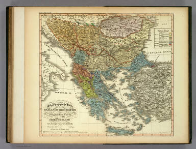
Full Title
Ethnographische Karte des Osmanischen Reichs europaischen Theils und von Griechenland. Dem Herausgeber des Physikal. Atlas von seinem ethnologischen Freunde. Wien, 3 Marz 1847. Gotha, bei J. Perthes 1847. 8te Abtheilung: Ethnographie No 19.
List No
2515.082
Note
A full color ethnographic map of Greece and the Ottoman Empire.
Author
[Berghaus, Heinrich, Berghaus, Hermann]
Full Title
(Covers to) Berghaus' Physikalischer Atlas. (Begrundet 1836 durch Heinrich Berghaus). Dritte Ausgabe. 75 Karten in sieben Abteilungen enthaltend 514 Darstellungen uber Geologie, Hydrographie, Meteorologie, Erdmagnetismus, Pflanzenverbreitung, Tierverbreitung und Volkerkunde. Vollstandig neu bearbeitet und unter Mitwirkung von Dr. Oscar Drude ... Dr. Georg Gerland ... Dr. Julius Hann ... Dr. William Marshall ... Dr. Georg Neumayer ... Dr. Karl v. Zittel ... herausgegeben von Prof. Dr. Herm. Berghaus. Gotha: Justus Perthes. 1892.
List No
4391.001
Note
New edition of Berghaus' Atlas in seven parts : I: Geologie, II: Hydrographie, III: Meteorologie, IV: Erdmagnetismus, V: Pflanzenverbreitung, VI: Tierverbreitung, VII: Volkerkunde, with individual title pages dated variously 1887, 1891, and 1892, indicating that each was also published separately (see our copy of Atlas der Geologie). This is a new edition, updated by Berghaus' son, with all the maps completely redone, and still, amazingly, hand colored in a style equal to the first edition. There are actually only 74 maps, No. 7/8 are combined in one plate. Atlas is bound in half leather black cloth covered boards with "Berghaus' Physikal. Atlas." stamped in gilt on the front cover and spine.
Author
[Berghaus, Heinrich, Berghaus, Hermann]
Full Title
(Text Page to) Vorwort: Berghaus' Physikalischer Atlas. (Begrundet 1836 durch Heinrich Berghaus). Dritte Ausgabe. 75 Karten in sieben Abteilungen enthaltend 514 Darstellungen uber Geologie, Hydrographie, Meteorologie, Erdmagnetismus, Pflanzenverbreitung, Tierverbreitung und Volkerkunde. Vollstandig neu bearbeitet und unter Mitwirkung von Dr. Oscar Drude ... Dr. Georg Gerland ... Dr. Julius Hann ... Dr. William Marshall ... Dr. Georg Neumayer ... Dr. Karl v. Zittel ... herausgegeben von Prof. Dr. Herm. Berghaus. Gotha: Justus Perthes. 1892.
List No
4391.003
Note
New edition of Berghaus' Atlas in seven parts : I: Geologie, II: Hydrographie, III: Meteorologie, IV: Erdmagnetismus, V: Pflanzenverbreitung, VI: Tierverbreitung, VII: Volkerkunde, with individual title pages dated variously 1887, 1891, and 1892, indicating that each was also published separately (see our copy of Atlas der Geologie). This is a new edition, updated by Berghaus' son, with all the maps completely redone, and still, amazingly, hand colored in a style equal to the first edition. There are actually only 74 maps, No. 7/8 are combined in one plate. Atlas is bound in half leather black cloth covered boards with "Berghaus' Physikal. Atlas." stamped in gilt on the front cover and spine.
Author
[Berghaus, Heinrich, Berghaus, Hermann]
Full Title
(Text Page to) Vorwort: Berghaus' Physikalischer Atlas. (Begrundet 1836 durch Heinrich Berghaus). Dritte Ausgabe. 75 Karten in sieben Abteilungen enthaltend 514 Darstellungen uber Geologie, Hydrographie, Meteorologie, Erdmagnetismus, Pflanzenverbreitung, Tierverbreitung und Volkerkunde. Vollstandig neu bearbeitet und unter Mitwirkung von Dr. Oscar Drude ... Dr. Georg Gerland ... Dr. Julius Hann ... Dr. William Marshall ... Dr. Georg Neumayer ... Dr. Karl v. Zittel ... herausgegeben von Prof. Dr. Herm. Berghaus. Gotha: Justus Perthes. 1892.
List No
4391.004
Note
New edition of Berghaus' Atlas in seven parts : I: Geologie, II: Hydrographie, III: Meteorologie, IV: Erdmagnetismus, V: Pflanzenverbreitung, VI: Tierverbreitung, VII: Volkerkunde, with individual title pages dated variously 1887, 1891, and 1892, indicating that each was also published separately (see our copy of Atlas der Geologie). This is a new edition, updated by Berghaus' son, with all the maps completely redone, and still, amazingly, hand colored in a style equal to the first edition. There are actually only 74 maps, No. 7/8 are combined in one plate. Atlas is bound in half leather black cloth covered boards with "Berghaus' Physikal. Atlas." stamped in gilt on the front cover and spine.sikal. Atlas." stamped in gilt on the front cover and spine.
Author
[Berghaus, Heinrich, Berghaus, Hermann]
Full Title
(Contents to) Inhalt: Berghaus' Physikalischer Atlas. (Begrundet 1836 durch Heinrich Berghaus). Dritte Ausgabe. 75 Karten in sieben Abteilungen enthaltend 514 Darstellungen uber Geologie, Hydrographie, Meteorologie, Erdmagnetismus, Pflanzenverbreitung, Tierverbreitung und Volkerkunde. Vollstandig neu bearbeitet und unter Mitwirkung von Dr. Oscar Drude ... Dr. Georg Gerland ... Dr. Julius Hann ... Dr. William Marshall ... Dr. Georg Neumayer ... Dr. Karl v. Zittel ... herausgegeben von Prof. Dr. Herm. Berghaus. Gotha: Justus Perthes. 1892.
List No
4391.005
Note
New edition of Berghaus' Atlas in seven parts : I: Geologie, II: Hydrographie, III: Meteorologie, IV: Erdmagnetismus, V: Pflanzenverbreitung, VI: Tierverbreitung, VII: Volkerkunde, with individual title pages dated variously 1887, 1891, and 1892, indicating that each was also published separately (see our copy of Atlas der Geologie). This is a new edition, updated by Berghaus' son, with all the maps completely redone, and still, amazingly, hand colored in a style equal to the first edition. There are actually only 74 maps, No. 7/8 are combined in one plate. Atlas is bound in half leather black cloth covered boards with "Berghaus' Physikal. Atlas." stamped in gilt on the front cover and spine.
Author
[Berghaus, Heinrich, Berghaus, Hermann]
Full Title
(Contents to) Inhalt: Berghaus' Physikalischer Atlas. (Begrundet 1836 durch Heinrich Berghaus). Dritte Ausgabe. 75 Karten in sieben Abteilungen enthaltend 514 Darstellungen uber Geologie, Hydrographie, Meteorologie, Erdmagnetismus, Pflanzenverbreitung, Tierverbreitung und Volkerkunde. Vollstandig neu bearbeitet und unter Mitwirkung von Dr. Oscar Drude ... Dr. Georg Gerland ... Dr. Julius Hann ... Dr. William Marshall ... Dr. Georg Neumayer ... Dr. Karl v. Zittel ... herausgegeben von Prof. Dr. Herm. Berghaus. Gotha: Justus Perthes. 1892.
List No
4391.006
Note
New edition of Berghaus' Atlas in seven parts : I: Geologie, II: Hydrographie, III: Meteorologie, IV: Erdmagnetismus, V: Pflanzenverbreitung, VI: Tierverbreitung, VII: Volkerkunde, with individual title pages dated variously 1887, 1891, and 1892, indicating that each was also published separately (see our copy of Atlas der Geologie). This is a new edition, updated by Berghaus' son, with all the maps completely redone, and still, amazingly, hand colored in a style equal to the first edition. There are actually only 74 maps, No. 7/8 are combined in one plate. Atlas is bound in half leather black cloth covered boards with "Berghaus' Physikal. Atlas." stamped in gilt on the front cover and spine.
Author
[Berghaus, Heinrich, Berghaus, Hermann]
Full Title
(Contents to) Inhalt: Berghaus' Physikalischer Atlas. (Begrundet 1836 durch Heinrich Berghaus). Dritte Ausgabe. 75 Karten in sieben Abteilungen enthaltend 514 Darstellungen uber Geologie, Hydrographie, Meteorologie, Erdmagnetismus, Pflanzenverbreitung, Tierverbreitung und Volkerkunde. Vollstandig neu bearbeitet und unter Mitwirkung von Dr. Oscar Drude ... Dr. Georg Gerland ... Dr. Julius Hann ... Dr. William Marshall ... Dr. Georg Neumayer ... Dr. Karl v. Zittel ... herausgegeben von Prof. Dr. Herm. Berghaus. Gotha: Justus Perthes. 1892.
List No
4391.007
Note
New edition of Berghaus' Atlas in seven parts : I: Geologie, II: Hydrographie, III: Meteorologie, IV: Erdmagnetismus, V: Pflanzenverbreitung, VI: Tierverbreitung, VII: Volkerkunde, with individual title pages dated variously 1887, 1891, and 1892, indicating that each was also published separately (see our copy of Atlas der Geologie). This is a new edition, updated by Berghaus' son, with all the maps completely redone, and still, amazingly, hand colored in a style equal to the first edition. There are actually only 74 maps, No. 7/8 are combined in one plate. Atlas is bound in half leather black cloth covered boards with "Berghaus' Physikal. Atlas." stamped in gilt on the front cover and spine.
Author
[Berghaus, Heinrich, Berghaus, Hermann]
Full Title
(Title Page/Contents to) Atlas der geologie (Berghaus' Physikalischer Atlas, Abteilung I) 15 kolorierte karten in kupfersticch mit 150 darstellungen. Unter beratender Mitwirkung von Prof. Dr. K. v. Zittel bearbeitet von Dr. Hermann Berghaus ... Gotha: Justus Perthes. 1892.
List No
4391.008
Note
Title page to Part 1: Geologie. Includes contents.
Author
[Berghaus, Heinrich, Berghaus, Hermann]
Full Title
(Text Page to) Vorbemerkungen. Atlas der geologie (Berghaus' Physikalischer Atlas, Abteilung I) 15 kolorierte karten in kupfersticch mit 150 darstellungen. Unter beratender Mitwirkung von Prof. Dr. K. v. Zittel bearbeitet von Dr. Hermann Berghaus ... Gotha: Justus Perthes. 1892.
List No
4391.009
Note
Text to the 1st. Part: Geologie.
Author
[Berghaus, Heinrich, Berghaus, Hermann]
Full Title
(Text Page to) Vorbemerkungen. Atlas der geologie (Berghaus' Physikalischer Atlas, Abteilung I) 15 kolorierte karten in kupfersticch mit 150 darstellungen. Unter beratender Mitwirkung von Prof. Dr. K. v. Zittel bearbeitet von Dr. Hermann Berghaus ... Gotha: Justus Perthes. 1892.
List No
4391.010
Note
Text to the 1st. Part: Geologie.
Author
[Berghaus, Heinrich, Berghaus, Hermann]
Full Title
(Text Page to) Vorbemerkungen. Atlas der geologie (Berghaus' Physikalischer Atlas, Abteilung 1) 15 kolorierte karten in kupfersticch mit 150 darstellungen. Unter beratender Mitwirkung von Prof. Dr. K. v. Zittel bearbeitet von Dr. Hermann Berghaus ... (to Accompany) Berghaus' Physikalischer Atlas. (Begrundet 1836 durch Heinrich Berghaus) ... Gotha: Justus Perthes. 1892.
List No
4391.011
Note
Text to the 1st. Part: Geologie.
Author
[Berghaus, Heinrich, Berghaus, Hermann, Luddecke, R., Rohrbach, C.]
Full Title
Ubersicht der Erde. Bearbeitet v. Dr. R. Luddecke & Dr. C. Rohrbach. Ausgabe 1892. Gotha: Justus Perthes. (On upper margin) I. Abt. Geologie No. VII/VIII. Berghaus' physikal atlas No. 7/8. (to Accompany) Berghaus' Physikalischer Atlas. (Begrundet 1836 durch Heinrich Berghaus) ... Gotha: Justus Perthes. 1892. (insets) Wahrscheinliche Ausdehnung des Festlandes zur Jurazeit (nach Neumayr. (with) Verbreitung der Kohle. (with) Verbreitung der jungen Kettengebirge und des pazifischen u. atlantischen Kustentypus.
List No
4391.018
Note
Color lithograph map of the world with 3 insets. Includes statistical tables and colors explanation.
Author
[Berghaus, Heinrich, Berghaus, Hermann, Luddecke, R., Rohrbach, C.]
Full Title
Europa. Entw. v. Herm. Berghaus 1889, Ausg. 1889. Gest. v. A. Herrmann. Gotha: Justus Perthes. (On upper margin) I. Abt. Geologie No. IX. Berghaus' physikal atlas No. 9. (to Accompany) Berghaus' Physikalischer Atlas. (Begrundet 1836 durch Heinrich Berghaus) ... Gotha: Justus Perthes. 1892. (7 insets).
List No
4391.019
Note
Color lithograph map with 7 insets: Laki (Island) -- Vulcano -- Die Pyrenaeen -- Spitzbergen -- Schonen -- Der Kaukasus -- Gletscher des Adai-Choch. Showing major cities, towns, rivers and river basins. Principal geological features are shown by color or symbols. Relief shown by contours and spot heights. Depth shown by isolines and soundings. Includes table of geologic formations and abbreviations.
Author
[Berghaus, Heinrich, Berghaus, Hermann]
Full Title
Alpenlander. Entw. v. Herm. Berghaus 1889, Ausg. 1890. Gest. v. A. Herrmann. Gotha: Justus Perthes. (On upper margin) I. Abt. Geologie No. X. Berghaus' physikal atlas No. 10. (to Accompany) Berghaus' Physikalischer Atlas. (Begrundet 1836 durch Heinrich Berghaus) ... Gotha: Justus Perthes. 1892. (insets) Aus den Dolomiten n. v. Mojsisovics. (inset profiles) Durchschnitt der Ostalpan (with) Durchschnitt der Westalpen.
List No
4391.020
Note
Color lithograph map. Showing major cities, towns, rivers and river basins. Principal geological features are shown by color or symbols. Relief shown by contours and spot heights. Depth shown by isolines and soundings. Includes table of geologic formations and abbreviations. Prime meridian is Greenwich.
Author
[Berghaus, Heinrich, Berghaus, Hermann, Poppey, K., Grabhein, P.]
Full Title
Asien und Europa. Entw. v. Herm. Berghaus 1887, Ausg. 1889. Gest. v. K. Poppey u. P. Grabhein. Gotha: Justus Perthes. (On upper margin) I. Abt. Geologie No. XI. Berghaus' physikal atlas No. 11. (to Accompany) Berghaus' Physikalischer Atlas. (Begrundet 1836 durch Heinrich Berghaus) ... Gotha: Justus Perthes. 1892. (insets) Japan von Dr. Edm. Naumann, Korea von Dr. C. Gottsche. (with) Indisches Salz-Gebirge. (with) Lavastrom des Asama Jama von J.1783. (with) Java nach F. Junghulm.
List No
4391.021
Note
Color lithograph map. Showing major cities, towns, rivers, lakes and river basins. Principal geological features are shown by color or symbols. Relief shown by contours and spot heights. Depth shown by isolines and soundings. Includes table of geologic formations. Prime meridian is Greenwich.
Author
[Berghaus, Heinrich, Berghaus, Hermann, Risch, M., Reichenbecher, A., Kogel, F.]
Full Title
Afrika. Entw. v. Herm. Berghaus 1887, Ausg. 1888. 7 Nebenkarten gez. v. M. Risch, gest. v. A. Reichenbecher & F. Kogel. Gotha: Justus Perthes. (On upper margin) I. Abt. Geologie No. XII. Berghaus' physikal atlas No. 12. (to Accompany) Berghaus' Physikalischer Atlas. (Begrundet 1836 durch Heinrich Berghaus) ... Gotha: Justus Perthes. 1892. (11 insets)
List No
4391.022
Note
Color lithograph map. Insets: Pic von Tenerife -- Bu-Chail-Gebirge (Algerien) -- Kamerun-Gebirge -- Gebirgslauf des Congo -- Atlas-Lander -- Capland -- Kilima-Ndsharo -- Oase Chargeh nach K. v. Zittel -- Abyssinien -- Amba-Landschaft -- Magdala. Showing major cities, ports, canals and river basins. Principal geological features are shown by color or symbols. Relief shown by contours and spot heights. Depth shown by isolines and soundings. Includes table of geologic formations. Prime meridian is Greenwich.
Author
[Berghaus, Heinrich, Berghaus, Hermann, Risch, M.]
Full Title
Nord-Amerika. Ubersicht von Nord-Amerika. Entw. v. Herm. Berghaus 1886, Ausg. 1887. Nebenkarten gez. v. M. Risch. Gotha: Justus Perthes. (On upper margin) I. Abt. Geologie No. XIII. Berghaus' physikal atlas No. 13. (to Accompany) Berghaus' Physikalischer Atlas. (Begrundet 1836 durch Heinrich Berghaus) ... Gotha: Justus Perthes. 1892. (12 insets).
List No
4391.023
Note
Color lithograph map. Insets: Virginia-Silber-Minen -- Das Yosemite-Thal -- Landenge von Tehuantepec -- Landenge von Nicaragua -- Die Krater des Turrialba -- Landenge von Panama -- Seeboden der New-York-Bay -- Popocatepetl -- Citlaltepetl -- Canons des Colorado --Yellowstone-National -Park -- Reykjanes und Geyser. Showing major cities, towns, rivers and river basins. Principal geological features are shown by color or symbols. Relief shown by contours and spot heights. Depth shown by isolines and soundings. Includes table. Prime meridian is Greenwich.
Author
[Berghaus, Heinrich, Berghaus, Hermann, Steinmann, G., Luddecke, R., Geyer, F.]
Full Title
Sud-Amerika. Ubersicht von Nord-Amerika. Bearb. v. G. Steinmann u. H. Berghaus, red. v. R. Luddecke. Ausgabe 1891. Gest. v. F. Geyer. Gotha: Justus Perthes. (On upper margin) I. Abt. Geologie No. XIV. Berghaus' physikal atlas No. 14. (to Accompany) Berghaus' Physikalischer Atlas. (Begrundet 1836 durch Heinrich Berghaus) ... Gotha: Justus Perthes. 1892. (7 insets).
List No
4391.024
Note
Color lithograph map. Insets: Vulcan Descabezado --Cordillere von Copiapo -- Durchschnitt des Westabhanges der Cordillere von Copiapo -- Minen von Callao -- Laguna de San Rafael -- Sierra Nevada de Cocui -- Durchschnitt des Sergipe-Alagoas Beckens. Showing lakes, rivers and river basins. Principal geological features are shown by color or symbols. Relief shown by contours and spot heights. Depth shown by isolines and soundings. Includes table and text. Prime meridian is Greenwich.
Author
[Berghaus, Heinrich, Berghaus, Hermann, Luddecke, R., Geyer, F.]
Full Title
Oceanien. Entw. v. H. Berghaus 1886, Ausg. 1888. Gotha: Justus Perthes. (On upper margin) I. Abt. Geologie No. XV. Berghaus' physikal atlas No. 15. (to Accompany) Berghaus' Physikalischer Atlas. (Begrundet 1836 durch Heinrich Berghaus) ... Gotha: Justus Perthes. 1892. (19 insets).
List No
4391.025
Note
Color lithograph map. Insets: Victoria -- Tasmanien -- Landenge von Auckland -- Maunga Rei -- Das Seenland -- Hawaii-Vulkane -- Roto-Mahana -- Honolulu -- Makatea -- Bolabola -- Totoya -- Niuafu -- Tova Riff -- Vuata Vatua -- Nukufetau -- Taiara -- Washington -- Jervis -- Enderbury.Showing majorrivers and river basins. Principal geological features are shown by color or symbols. Relief shown by contours and spot heights. Depth shown by isolines and soundings. Includes table of geologic formations. Prime meridian is Greenwich.
Author
[Berghaus, Heinrich, Berghaus, Hermann, Luddecke, R., Geyer, F.]
Full Title
(Title Page/Contents to) Atlas der hydrographie. (Berghaus' physikalischer atlas, Abteilung II.) 11 kolorierte Karten in Kupferstich mit 173 Darstellungen. Bearbeitet von Dr. Hermann Berghaus. Gotha: Justus Perthes. 1891. (to Accompany) Berghaus' Physikalischer Atlas. (Begrundet 1836 durch Heinrich Berghaus) ... Gotha: Justus Perthes. 1892.
List No
4391.026
Note
Title page to Part 2: Hydrographie. Includes contents.
Author
[Berghaus, Heinrich, Berghaus, Hermann, Luddecke, R., Geyer, F.]
Full Title
(Text Page to) Vorbemerkungen. Atlas der hydrographie. (Berghaus' physikalischer atlas, Abteilung II.) 11 kolorierte Karten in Kupferstich mit 173 Darstellungen. Bearbeitet von Dr. Hermann Berghaus. Gotha: Justus Perthes. 1891. (to Accompany) Berghaus' Physikalischer Atlas. (Begrundet 1836 durch Heinrich Berghaus) ... Gotha: Justus Perthes. 1892.
List No
4391.027
Note
Text to the 2nd. part: Hydrologie.
Author
[Berghaus, Heinrich, Berghaus, Hermann, Luddecke, R., Geyer, F.]
Full Title
(Text Page to) Vorbemerkungen. Atlas der hydrographie. (Berghaus' physikalischer atlas, Abteilung II.) 11 kolorierte Karten in Kupferstich mit 173 Darstellungen. Bearbeitet von Dr. Hermann Berghaus. Gotha: Justus Perthes. 1891. (to Accompany) Berghaus' Physikalischer Atlas. (Begrundet 1836 durch Heinrich Berghaus) ... Gotha: Justus Perthes. 1892.
List No
4391.028
Note
Text to the 2nd. part: Hydrologie.
Author
[Berghaus, Heinrich, Berghaus, Hermann]
Full Title
Land und wasserteilung. Strom-gebiete der Erde. in Lambert's flachenrechter Azimutal projection. Entw. v. Herm. Berghaus 1884, Ausg. 1886. Gotha: Justus Perthes. (On upper margin) II. Abt. Hydrographie No. I. Berghaus' physikal atlas No. 16. Atlas der hydrographie. (Berghaus' physikalischer atlas, Abteilung II). (to Accompany) Berghaus' Physikalischer Atlas. (Begrundet 1836 durch Heinrich Berghaus) ... Gotha: Justus Perthes. 1892. (11 insets).
List No
4391.029
Note
Color lithograph double hemisphere hydrological map, with inset maps and cross section. Shows ocean currents, drainage basins, watersheds, principal rivers and streams. Relief shown by hachures and spot heights. Insets: Zwiefache Quellen Hallingdal -- Gabelung des Orinoco -- Wasserteilung zwischen Severn -- Gabelung der Hasse -- Wasserteilung in Hardanger -- Quelle des Rauma & Logen -- Gabelung ded Tornea Elf -- Zeitweise wasserteilung des Manytsch -- Zeitweise gabelung des Serbewel -- Gabelung des Bahr el Dshebi and profile: Grosse des Landes. Includes explanation table.
Author
[Berghaus, Heinrich, Berghaus, Hermann, Schmidt, C., Hess, O.]
Full Title
Fliessende gewasser. Entw. v. Herm. Berghaus 1890, Ausg. 1890. Wasserfalle gez. v. C. Schmidt, gest. v. O. Hess. Gotha: Justus Perthes. (On upper margin) II. Abt. Hydrographie No. II. Berghaus' physikal atlas No. 17. Atlas der hydrographie. (Berghaus' physikalischer atlas, Abteilung II). (to Accompany) Berghaus' Physikalischer Atlas. (Begrundet 1836 durch Heinrich Berghaus) ... Gotha: Justus Perthes. 1892.
List No
4391.030
Note
30 color lithograph hydrological maps on 1 sheet. Shows river basins, watersheds, canals, principal rivers and streams. Relief shown by hachures, gradient tints and spot heights. Depth shown by isolines and soundings. Includes explanation table.
Author
[Berghaus, Heinrich, Berghaus, Hermann, Luddecke, R., Geyer, F.]
Full Title
Stehende gewasser. Entw. v. Herm. Berghaus 1890, Ausg. 1890. Red. v. R. Luddecke. Gest. v. F. Geyer. Gotha: Justus Perthes. (On upper margin) II. Abt. Hydrographie No. III. Berghaus' physikal atlas No. 18. Atlas der hydrographie. (Berghaus' physikalischer atlas, Abteilung II). (to Accompany) Berghaus' Physikalischer Atlas. (Begrundet 1836 durch Heinrich Berghaus) ... Gotha: Justus Perthes. 1892.
List No
4391.031
Note
27 color lithograph hydrological maps on 1 sheet. Shows watersheds, canals, lakes and wetlands. Relief shown by hachures and spot heights. Includes explanation table and depth gradient diagram.
Author
[Berghaus, Heinrich, Berghaus, Hermann]
Full Title
Seetiefen, Kusten, Hafen, Dichte de seewassers. Entw. v. Herm. Berghaus 1886, Ausg. 1887. Gotha: Justus Perthes. (On upper margin) II. Abt. Hydrographie No. IV. Berghaus' physikal atlas No. 19. Atlas der hydrographie. (Berghaus' physikalischer atlas, Abteilung II). (to Accompany) Berghaus' Physikalischer Atlas. (Begrundet 1836 durch Heinrich Berghaus) ... Gotha: Justus Perthes. 1892. (10 insets).
List No
4391.032
Note
Outline color lithograph map of the world. Includes 9 inset maps and 1 profile. Shows lakes, tides and currents, shorelines and coastal operations. Relief shown by hachures. Depth shown by gradient tints, isolines and soundings. Includes explanation table. Prime meridian is Greenwich.
Author
[Berghaus, Heinrich, Berghaus, Hermann]
Full Title
Fluthwrchsel, Tidestrome, Gang der hafenzeiten. Entw. v. Herm. Berghaus 1889, Ausg. 1890. Gotha: Justus Perthes. (On upper margin) II. Abt. Hydrographie No. V. Berghaus' physikal atlas No. 20. Atlas der hydrographie. (Berghaus' physikalischer atlas, Abteilung II). (to Accompany) Berghaus' Physikalischer Atlas. (Begrundet 1836 durch Heinrich Berghaus) ... Gotha: Justus Perthes. 1892. (insets) Tidenbegegund im hohen Norden. (with) Fluthwechsel an der Magalhae's - Strasse. (with)Fluthwechsel am St, Laurenz -Golf. (with) Gebiet der Mascarets. (with) Fluthwechsel am Armel-Canal.
List No
4391.033
Note
Outline color lithograph hydrological map of the world. Includes 7 tidal charts and 1 graph. Shows tides, currents and shorelines. Depth shown by gradient tints, isolines and soundings. Includes explanation table.
Author
[Berghaus, Heinrich, Berghaus, Hermann, Kogel, F.]
Full Title
Seestromungen, warme und treibfrachte der see. Entw. v. Herm. Berghaus 1888, Ausg. 1889. Gest. v. F. Kogel. Gotha: Justus Perthes. (On upper margin) II. Abt. Hydrographie No. VI. Berghaus' physikal atlas No. 21. Atlas der hydrographie. (Berghaus' physikalischer atlas, Abteilung II). (to Accompany) Berghaus' Physikalischer Atlas. (Begrundet 1836 durch Heinrich Berghaus) ... Gotha: Justus Perthes. 1892. (insets) Ware des seewassers an der Oberflache. (with) Mexikanisches Monsun-Gebiet im Nordwinter. (with) Indisches Monsun-Gebiet im Nordwinter. (with) Warme des seewassers am Grunde.
List No
4391.034
Note
Outline color lithograph hydrological map of the world. Includes tidal graph. Shows tidal lines and ocean currents. Depth shown by gradient tints, isolines and soundings. Includes explanation table.
Author
[Berghaus, Heinrich, Berghaus, Hermann, Hess, O.]
Full Title
Stromungen, warme der see. Im Februar und im August. Stromungen der seeoberflache im Februar. Stromungen der seeoberflache im August. Warme des seewassers an der Oberflache im Februar. Warme des seewassers an der Oberflache im August. Entw. v. Herm. Berghaus 1888, Ausg. 1889. Gest. v. O. Hess. Gotha: Justus Perthes. (On upper margin) II. Abt. Hydrographie No. VII. Berghaus' physikal atlas No. 22. Atlas der hydrographie. (Berghaus' physikalischer atlas, Abteilung II). (to Accompany) Berghaus' Physikalischer Atlas. (Begrundet 1836 durch Heinrich Berghaus) ... Gotha: Justus Perthes. 1892.
List No
4391.035
Note
4 color lithograph meteorological maps of the world on 2 sheets. With 4 inset maps and 4 gradient diagrams. Shows the global surface current system and global mean surface temperature in February and August. Depth shown by gradient tints and soundings. Includes explanation table.
Author
[Berghaus, Heinrich, Berghaus, Hermann]
Full Title
Nord - und Ostsee. Entw. v. Herm. Berghaus 1883, Ausg. 1886. Gotha: Justus Perthes. (On upper margin) II. Abt. Hydrographie No. VIII. Berghaus' physikal atlas No. 23. Atlas der hydrographie. (Berghaus' physikalischer atlas, Abteilung II). (to Accompany) Berghaus' Physikalischer Atlas. (Begrundet 1836 durch Heinrich Berghaus) ... Gotha: Justus Perthes. 1892.
List No
4391.036
Note
Outline color lithograph map. With 5 depth gradient diagrams, and 11 inset maps. Showing physical characteristics, tides and current system of the North Sea and Baltic Sea. Includes map explanation table . Depth shown by isolines, bathymetric tints and soundings. Relief shown by hachures and spot heights. Prime meridian is Greenwich.
Author
[Berghaus, Heinrich, Berghaus, Hermann]
Full Title
Mittellandisches und Schwarzes Meer. Entw. v. Herm. Berghaus 1883, Ausg. 1886. Gotha: Justus Perthes. (On upper margin) II. Abt. Hydrographie No. IX. Berghaus' physikal atlas No. 24. Atlas der hydrographie. (Berghaus' physikalischer atlas, Abteilung II). (to Accompany) Berghaus' Physikalischer Atlas. (Begrundet 1836 durch Heinrich Berghaus) ... Gotha: Justus Perthes. 1892.
List No
4391.037
Note
Color lithograph hydrographic map of Mediterranean Sea and Black sea. With 21 inset maps, profile showing Gibraltar Strait and depth gradient diagram. Showing tides, current system, canals, river basin, harbors, ports, delta, lagoon, etc. Includes explanation table. Depth shown by isolines, bathymetric tints and soundings. Relief shown by hachures and spot heights. Prime meridian is Greenwich.
Author
[Berghaus, Heinrich, Berghaus, Hermann, Barich, C.]
Full Title
Ostindien & China. Entw. v. Herm. Berghaus 1883, Ausg. 1888. Tiefenl gez. v. C. Barich. Gotha: Justus Perthes. (On upper margin) II. Abt. Hydrographie No. X. Berghaus' physikal atlas No. 25. Atlas der hydrographie. (Berghaus' physikalischer atlas, Abteilung II). (to Accompany) Berghaus' Physikalischer Atlas. (Begrundet 1836 durch Heinrich Berghaus) ... Gotha: Justus Perthes. 1892.
List No
4391.038
Note
Color lithograph hydrographic map of Southeast Asia. With 9 inset maps and 1 depth gradient diagram. Showing tides, current system, canals, etc. Includes table. Depth shown by isolines, bathymetric tints and soundings. Relief shown by hachures and spot heights. Prime meridian is Greenwich.
Author
[Berghaus, Heinrich, Berghaus, Hermann, Risch, M.]
Full Title
Westindien. Entw. v. Herm. Berghaus 1883, Ausg. 1888. Tiefenl gez. v. M. Risch. Gotha: Justus Perthes. (On upper margin) II. Abt. Hydrographie No. XI. Berghaus' physikal atlas No. 26. Atlas der hydrographie. (Berghaus' physikalischer atlas, Abteilung II). (to Accompany) Berghaus' Physikalischer Atlas. (Begrundet 1836 durch Heinrich Berghaus) ... Gotha: Justus Perthes. 1892.
List No
4391.039
Note
Color lithograph hydrographic map of West Indies. With 7 inset maps and 2 depth gradient diagram. Showing tides, current system, river basins, canals, delta, etc. Includes explanation and abbreviation tables. Depth shown by isolines, bathymetric tints and soundings. Prime meridian is Greenwich.
Author
[Berghaus, Heinrich, Hann, Julius]
Full Title
(Title Page/Contents to) Atlas der Meteorologie (Berghaus' physikalischer atlas, Abteilung III). 12 kolorierte Karten in Kupferstich mit 63 Darstellungen. Bearbeitet von Dr. Julius Hann. Gotha: Justus Perthes. 1887. (to Accompany) Berghaus' Physikalischer Atlas. (Begrundet 1836 durch Heinrich Berghaus) ... Gotha: Justus Perthes. 1892.
List No
4391.040
Note
Title page to Part 3: Meteorologie. Includes contents.
Author
[Berghaus, Heinrich, Hann, Julius]
Full Title
(Text Page to) Vorbemerkungen. Atlas der Meteorologie (Berghaus' physikalischer atlas, Abteilung III). 12 kolorierte Karten in Kupferstich mit 63 Darstellungen. Bearbeitet von Dr. Julius Hann. Gotha: Justus Perthes. 1887. (to Accompany) Berghaus' Physikalischer Atlas. (Begrundet 1836 durch Heinrich Berghaus) ... Gotha: Justus Perthes. 1892.
List No
4391.041
Note
Text to the 3rd. Part: Meteorologie.
Author
[Berghaus, Heinrich, Hann, Julius]
Full Title
(Text Page to) Vorbemerkungen. Atlas der Meteorologie (Berghaus' physikalischer atlas, Abteilung III). 12 kolorierte Karten in Kupferstich mit 63 Darstellungen. Bearbeitet von Dr. Julius Hann. Gotha: Justus Perthes. 1887. (to Accompany) Berghaus' Physikalischer Atlas. (Begrundet 1836 durch Heinrich Berghaus) ... Gotha: Justus Perthes. 1892.
List No
4391.042
Note
Text to the 3rd. Part: Meteorologie.
Author
[Berghaus, Heinrich, Hann, Julius]
Full Title
(Text Page to) Vorbemerkungen. Atlas der Meteorologie (Berghaus' physikalischer atlas, Abteilung III). 12 kolorierte Karten in Kupferstich mit 63 Darstellungen. Bearbeitet von Dr. Julius Hann. Gotha: Justus Perthes. 1887. (to Accompany) Berghaus' Physikalischer Atlas. (Begrundet 1836 durch Heinrich Berghaus) ... Gotha: Justus Perthes. 1892.
List No
4391.043
Note
Text to the 3rd. Part: Meteorologie.
Author
[Berghaus, Heinrich, Hann, Julius]
Full Title
(Text Page to) Vorbemerkungen. Atlas der Meteorologie (Berghaus' physikalischer atlas, Abteilung III). 12 kolorierte Karten in Kupferstich mit 63 Darstellungen. Bearbeitet von Dr. Julius Hann. Gotha: Justus Perthes. 1887. (to Accompany) Berghaus' Physikalischer Atlas. (Begrundet 1836 durch Heinrich Berghaus) ... Gotha: Justus Perthes. 1892.
List No
4391.044
Note
Text to the 3rd. Part: Meteorologie.
Author
[Berghaus, Heinrich, Hann, Julius]
Full Title
(Text Page to) Vorbemerkungen. Atlas der Meteorologie (Berghaus' physikalischer atlas, Abteilung III). 12 kolorierte Karten in Kupferstich mit 63 Darstellungen. Bearbeitet von Dr. Julius Hann. Gotha: Justus Perthes. 1887. (to Accompany) Berghaus' Physikalischer Atlas. (Begrundet 1836 durch Heinrich Berghaus) ... Gotha: Justus Perthes. 1892.
List No
4391.045
Note
Text to the 3rd. Part: Meteorologie.
Author
[Berghaus, Heinrich, Hann, Julius]
Full Title
(Text Page to) Vorbemerkungen. Atlas der Meteorologie (Berghaus' physikalischer atlas, Abteilung III). 12 kolorierte Karten in Kupferstich mit 63 Darstellungen. Bearbeitet von Dr. Julius Hann. Gotha: Justus Perthes. 1887. (to Accompany) Berghaus' Physikalischer Atlas. (Begrundet 1836 durch Heinrich Berghaus) ... Gotha: Justus Perthes. 1892.
List No
4391.046
Note
Text to the 3rd. Part: Meteorologie.
Author
[Berghaus, Heinrich, Hann, Julius]
Full Title
Jahres - Isothermen. Entw. v. J. Hann 1884, Ausg. 1886. Gotha: Justus Perthes. (On upper margin) III. Abt. Meteorologie No. I. Berghaus' physikal atlas No. 27. Atlas der Meteorologie. (Berghaus' physikalischer atlas, Abteilung III). (to Accompany) Berghaus' Physikalischer Atlas. (Begrundet 1836 durch Heinrich Berghaus) ... Gotha: Justus Perthes. 1892. (insets) Jahres - Isanomalen nach Dive und Wild. (with) Jahres - Isothemen um den Nord-Pol. (with) Linien gleicher jahrlicher Warme-Schwankung nach supan und wild.
List No
4391.047
Note
Color climatological map of the earth's surface. Showing by Lines & Figures the Mean Annual Temperature of the principal places on the Globe. Isothermal lines indicate equal temperature at a given time or on average over a given period. Map shows boundaries and regions. Includes notes and temperature table. Prime meridian is Greenwich.
Author
[Berghaus, Heinrich, Hann, Julius]
Full Title
Januar - Isothermen. Entw. v. J. Hann 1884, Ausg. 1886. Gotha: Justus Perthes. (On upper margin) III. Abt. Meteorologie No. II. Berghaus' physikal atlas No. 28. Atlas der Meteorologie. (Berghaus' physikalischer atlas, Abteilung III). (to Accompany) Berghaus' Physikalischer Atlas. (Begrundet 1836 durch Heinrich Berghaus) ... Gotha: Justus Perthes. 1892. (insets) Januar - Isanomalen nach Teisserenc de Bort und Wild. (with) Winter - Isothemen um den Nord-Pol. (with) Januar-Isothermen im Asser - Tropischen sud-Amerika.
List No
4391.048
Note
Color climatological map of the earth's surface. Showing typical temperature patterns for the month of January on the Globe. Isothermal lines indicate equal temperature at a given time or on average over a given period. Map shows boundaries and regions. Includes notes and temperature table. Prime meridian is Greenwich.
Author
[Berghaus, Heinrich, Hann, Julius]
Full Title
Juli - Isothermen. Entw. v. J. Hann 1884, Ausg. 1886. Gotha: Justus Perthes. (On upper margin) III. Abt. Meteorologie No. III. Berghaus' physikal atlas No. 29. Atlas der Meteorologie. (Berghaus' physikalischer atlas, Abteilung III). (to Accompany) Berghaus' Physikalischer Atlas. (Begrundet 1836 durch Heinrich Berghaus) ... Gotha: Justus Perthes. 1892. (insets) Juli - Isanomalen nach Teisserenc de Bort und Wild. (with) Juli - Isothemen um den Nord-Pol. (with) Mai - Isothermen von Indien.
List No
4391.049
Note
Color climatological map of the earth's surface. Showing typical temperature patterns for the month of July on the Globe. Isothermal lines indicate equal temperature at a given time or on average over a given period. Map shows boundaries and regions. Includes notes and temperature table. Prime meridian is Greenwich.
Author
[Berghaus, Heinrich, Hann, Julius]
Full Title
Isothermen von Europa. Janur - Isothermen. Juli - Isothermen. Jahres - Isothermen. H. Hildebrandsson's wanderung der isothermen im Fruhling. Entw. v. J. Hann 1884, Ausg. 1887. Gotha: Justus Perthes. (On upper margin) III. Abt. Meteorologie No. IV. Berghaus' physikal atlas No. 30. Atlas der Meteorologie. (Berghaus' physikalischer atlas, Abteilung III). (to Accompany) Berghaus' Physikalischer Atlas. (Begrundet 1836 durch Heinrich Berghaus) ... Gotha: Justus Perthes. 1892.
List No
4391.050
Note
4 color climatological maps of Europe on 1 sheet. Showing typical temperature patterns for a year, Spring and months of January and July. Isothermal lines indicate equal temperature at a given time or on average over a given period. Map shows boundaries and regions. Includes explanation table. Prime meridian is Greenwich.
Author
[Berghaus, Heinrich, Hann, Julius]
Full Title
Isothermen von Nord - Amerika. Janur - Isothermen. Juli - Isothermen. Jahres - Isothermen. Janur - Isothermen der Ostlichen vereinigten staaten. Entw. v. J. Hann 1884, Ausg. 1887. Gotha: Justus Perthes. (On upper margin) III. Abt. Meteorologie No. V. Berghaus' physikal atlas No. 31. Atlas der Meteorologie. (Berghaus' physikalischer atlas, Abteilung III). (to Accompany) Berghaus' Physikalischer Atlas. (Begrundet 1836 durch Heinrich Berghaus) ... Gotha: Justus Perthes. 1892.
List No
4391.051
Note
4 color climatological maps of North America on 1 sheet. Showing typical temperature patterns for a year, months of January and July and eastern United States. Isothermal lines indicate equal temperature at a given time or on average over a given period. Map shows boundaries and regions. Includes explanation table. Prime meridian is Greenwich.
Author
[Berghaus, Heinrich, Hann, Julius]
Full Title
Isobaren im Jahre. Entw. v. J. Hann 1884, Ausg. 1887. Gotha: Justus Perthes. (On upper margin) III. Abt. Meteorologie No. VI. Berghaus' physikal atlas No. 32. Atlas der Meteorologie. (Berghaus' physikalischer atlas, Abteilung III). (to Accompany) Berghaus' Physikalischer Atlas. (Begrundet 1836 durch Heinrich Berghaus) ... Gotha: Justus Perthes. 1892. (insets) Mittlere Tiefe der minima. (with) Mittlere tagliche Barometer - Schwankung nach Buchan. (with) Jahres - Isobarem in Europa.
List No
4391.052
Note
Color climatological map of the earth's surface. Showing annual barometric pressure pattern using isobars in different parts of the world. Includes explanation table. Prime meridian is Greenwich.
Author
[Berghaus, Heinrich, Hann, Julius]
Full Title
Isobaren und winde im Januar. Entw. v. J. Hann 1884, Ausg. 1887. Gotha: Justus Perthes. (On upper margin) III. Abt. Meteorologie No. VII. Berghaus' physikal atlas No. 33. Atlas der Meteorologie. (Berghaus' physikalischer atlas, Abteilung III). (to Accompany) Berghaus' Physikalischer Atlas. (Begrundet 1836 durch Heinrich Berghaus) ... Gotha: Justus Perthes. 1892. (insets) Mittlere monatliche barometer - Schwankung. (with) Januar - isobaren und den Nord-Pol. (with) Januar - isobaren in Europa.
List No
4391.053
Note
Color climatological map of the earth's surface. Showing isobars and wind direction in January in different parts of the world. Includes explanation table. Prime meridian is Greenwich.
Author
[Berghaus, Heinrich, Hann, Julius]
Full Title
Isobaren und winde im Juli. Entw. v. J. Hann 1884, Ausg. 1887. Gotha: Justus Perthes. (On upper margin) III. Abt. Meteorologie No. VIII. Berghaus' physikal atlas No. 34. Atlas der Meteorologie. (Berghaus' physikalischer atlas, Abteilung III). (to Accompany) Berghaus' Physikalischer Atlas. (Begrundet 1836 durch Heinrich Berghaus) ... Gotha: Justus Perthes. 1892. (insets) Mittlere monatliche barometer - Schwankung im Juni, Juli, August. (with) Juli - isobaren und den Nord-Pol. (with) Juli - isobaren in Europa.
List No
4391.054
Note
Color climatological map of the earth's surface. Showing isobars and wind direction in July in different parts of the world. Includes explanation table. Prime meridian is Greenwich.
Author
[Berghaus, Heinrich, Hann, Julius]
Full Title
Witterungs - Anomalien in Europa. Isothermen des December 1879. 1879. Isothermen des December 1880. Isobaren des December 1880. Entw. v. J. Hann 1884, Ausg. 1886. Gotha: Justus Perthes. (On upper margin) III. Abt. Meteorologie No. IX. Berghaus' physikal atlas No. 35. Atlas der Meteorologie. (Berghaus' physikalischer atlas, Abteilung III). (to Accompany) Berghaus' Physikalischer Atlas. (Begrundet 1836 durch Heinrich Berghaus) ... Gotha: Justus Perthes. 1892.
List No
4391.055
Note
4 color maps on 1 sheet. Showing regional weather anomalies in Europe. Isothermal Lines, showing the mean temperature for December. Isobaric Lines prevailing atmospheric pressure for December. Prime meridian is Greenwich.
Author
[Berghaus, Heinrich, Hann, Julius, Koppen, W.]
Full Title
Wetterkarten und zungdtrassen der luftdruck - minima. haufigkeit und mittlere zugstrassen der barometrischen Minima. von W. Koppen. Fohn auf der norseite der Alpen. Entw. v. J. Hann 1884, Ausg. 1886. Gotha: Justus Perthes. (On upper margin) III. Abt. Meteorologie No. X. Berghaus' physikal atlas No. 36. Atlas der Meteorologie. (Berghaus' physikalischer atlas, Abteilung III). (to Accompany) Berghaus' Physikalischer Atlas. (Begrundet 1836 durch Heinrich Berghaus) ... Gotha: Justus Perthes. 1892.
List No
4391.056
Note
2 color climatological maps with 9 insets on 1 sheet, showing weather maps and flyways of atmospheric pressure. Prime meridian is Greenwich. Relief shown by hachures.
Author
[Berghaus, Heinrich, Hann, Julius, Loomis]
Full Title
Jahrliche regenmenge. Hahrliche verteilung der regenmenge uber die erde nach Loomis 1883. Entw. v. J. Hann 1884, Ausg. 1886. Gotha: Justus Perthes. (On upper margin) III. Abt. Meteorologie No. XI. Berghaus' physikal atlas No. 37. Atlas der Meteorologie. (Berghaus' physikalischer atlas, Abteilung III). (to Accompany) Berghaus' Physikalischer Atlas. (Begrundet 1836 durch Heinrich Berghaus) ... Gotha: Justus Perthes. 1892. (6 insets).
List No
4391.057
Note
Color climatological map with 6 insets on 1 sheet, showing annual precipitation chart of the World. Insets showing annual rainfall in United States, Central Europe, India, New Zealand, Jamaica and Mauritius. Prime meridian is Greenwich.
Author
[Berghaus, Heinrich, Hann, Julius]
Full Title
Regenkarte der Erde : zeitliche verteilung der Niederschlage. Entw. v. J. Hann 1885, Ausg. 1887. Gotha: Justus Perthes. (On upper margin) III. Abt. Meteorologie No. XII. Berghaus' physikal atlas No. 38. Atlas der Meteorologie. (Berghaus' physikalischer atlas, Abteilung III). (to Accompany) Berghaus' Physikalischer Atlas. (Begrundet 1836 durch Heinrich Berghaus) ... Gotha: Justus Perthes. 1892. (6 insets).
List No
4391.058
Note
Color climatological map of the world with 4 insets and 2 graphs on 1 sheet, showing distribution of rainfall around the world. Includes explanation table. Prime meridian is Greenwich.
Author
[Berghaus, Heinrich, Neumayer, Georg]
Full Title
(Title Page/Contents to) Atlas des Erdmagnetismus (Berghaus' physikalischer atlas, Abteilung IV). 5 kolorierte Karten in Kupferstich mit 20 Darstellungen. Bearbeitet von Dr. Georg Neumayer. Gotha: Justus Perthes. 1891. (to Accompany) Berghaus' Physikalischer Atlas. (Begrundet 1836 durch Heinrich Berghaus) ... Gotha: Justus Perthes. 1892.
List No
4391.059
Note
Title page to the Part 4: Erdmagnetismus. Includes contents.
Author
[Berghaus, Heinrich, Neumayer, Georg]
Full Title
(Text Page to) Vorbemerkungen. Atlas des Erdmagnetismus (Berghaus' physikalischer atlas, Abteilung IV). 5 kolorierte Karten in Kupferstich mit 20 Darstellungen. Bearbeitet von Dr. Georg Neumayer. Gotha: Justus Perthes. 1891. (to Accompany) Berghaus' Physikalischer Atlas. (Begrundet 1836 durch Heinrich Berghaus) ... Gotha: Justus Perthes. 1892.
List No
4391.060
Note
Text to Part 4. Erdmagnetismus.
Author
[Berghaus, Heinrich, Neumayer, Georg]
Full Title
(Text Page to) Vorbemerkungen. Atlas des Erdmagnetismus (Berghaus' physikalischer atlas, Abteilung IV). 5 kolorierte Karten in Kupferstich mit 20 Darstellungen. Bearbeitet von Dr. Georg Neumayer. Gotha: Justus Perthes. 1891. (to Accompany) Berghaus' Physikalischer Atlas. (Begrundet 1836 durch Heinrich Berghaus) ... Gotha: Justus Perthes. 1892.
List No
4391.061
Note
Text to Part 4. Erdmagnetismus.
Author
[Berghaus, Heinrich, Neumayer, Georg]
Full Title
(Text Page to) Vorbemerkungen. Atlas des Erdmagnetismus (Berghaus' physikalischer atlas, Abteilung IV). 5 kolorierte Karten in Kupferstich mit 20 Darstellungen. Bearbeitet von Dr. Georg Neumayer. Gotha: Justus Perthes. 1891. (to Accompany) Berghaus' Physikalischer Atlas. (Begrundet 1836 durch Heinrich Berghaus) ... Gotha: Justus Perthes. 1892.
List No
4391.062
Note
Text to Part 4. Erdmagnetismus.
Author
[Berghaus, Heinrich, Neumayer, Georg]
Full Title
(Text Page to) Vorbemerkungen. Atlas des Erdmagnetismus (Berghaus' physikalischer atlas, Abteilung IV). 5 kolorierte Karten in Kupferstich mit 20 Darstellungen. Bearbeitet von Dr. Georg Neumayer. Gotha: Justus Perthes. 1891. (to Accompany) Berghaus' Physikalischer Atlas. (Begrundet 1836 durch Heinrich Berghaus) ... Gotha: Justus Perthes. 1892.
List No
4391.063
Note
Text to Part 4. Erdmagnetismus.
Author
[Berghaus, Heinrich, Neumayer, Georg]
Full Title
(Text Page to) Vorbemerkungen. Atlas des Erdmagnetismus (Berghaus' physikalischer atlas, Abteilung IV). 5 kolorierte Karten in Kupferstich mit 20 Darstellungen. Bearbeitet von Dr. Georg Neumayer. Gotha: Justus Perthes. 1891. (to Accompany) Berghaus' Physikalischer Atlas. (Begrundet 1836 durch Heinrich Berghaus) ... Gotha: Justus Perthes. 1892.
List No
4391.064
Note
Text to Part 4. Erdmagnetismus.
Author
[Berghaus, Heinrich, Neumayer, Georg]
Full Title
(Text Page to) Vorbemerkungen. Atlas des Erdmagnetismus (Berghaus' physikalischer atlas, Abteilung IV). 5 kolorierte Karten in Kupferstich mit 20 Darstellungen. Bearbeitet von Dr. Georg Neumayer. Gotha: Justus Perthes. 1891. (to Accompany) Berghaus' Physikalischer Atlas. (Begrundet 1836 durch Heinrich Berghaus) ... Gotha: Justus Perthes. 1892.
List No
4391.065
Note
Text to Part 4. Erdmagnetismus.
Author
[Berghaus, Heinrich, Neumayer, Georg]
Full Title
(Text Page to) Vorbemerkungen. Atlas des Erdmagnetismus (Berghaus' physikalischer atlas, Abteilung IV). 5 kolorierte Karten in Kupferstich mit 20 Darstellungen. Bearbeitet von Dr. Georg Neumayer. Gotha: Justus Perthes. 1891. (to Accompany) Berghaus' Physikalischer Atlas. (Begrundet 1836 durch Heinrich Berghaus) ... Gotha: Justus Perthes. 1892.
List No
4391.066
Note
Text to Part 4. Erdmagnetismus.
Author
[Berghaus, Heinrich, Neumayer, Georg]
Full Title
(Text Page to) Vorbemerkungen. Atlas des Erdmagnetismus (Berghaus' physikalischer atlas, Abteilung IV). 5 kolorierte Karten in Kupferstich mit 20 Darstellungen. Bearbeitet von Dr. Georg Neumayer. Gotha: Justus Perthes. 1891. (to Accompany) Berghaus' Physikalischer Atlas. (Begrundet 1836 durch Heinrich Berghaus) ... Gotha: Justus Perthes. 1892.
List No
4391.067
Note
Text to Part 4. Erdmagnetismus.
Author
[Berghaus, Heinrich, Neumayer, Georg]
Full Title
(Text Page to) Vorbemerkungen. Atlas des Erdmagnetismus (Berghaus' physikalischer atlas, Abteilung IV). 5 kolorierte Karten in Kupferstich mit 20 Darstellungen. Bearbeitet von Dr. Georg Neumayer. Gotha: Justus Perthes. 1891. (to Accompany) Berghaus' Physikalischer Atlas. (Begrundet 1836 durch Heinrich Berghaus) ... Gotha: Justus Perthes. 1892.
List No
4391.068
Note
Text to Part 4. Erdmagnetismus.
Author
[Berghaus, Heinrich, Neumayer, Georg]
Full Title
(Text Page to) Vorbemerkungen. Atlas des Erdmagnetismus (Berghaus' physikalischer atlas, Abteilung IV). 5 kolorierte Karten in Kupferstich mit 20 Darstellungen. Bearbeitet von Dr. Georg Neumayer. Gotha: Justus Perthes. 1891. (to Accompany) Berghaus' Physikalischer Atlas. (Begrundet 1836 durch Heinrich Berghaus) ... Gotha: Justus Perthes. 1892.
List No
4391.069
Note
Text to Part 4. Erdmagnetismus.
Author
[Berghaus, Heinrich, Neumayer, Georg]
Full Title
Linien gleicher deklination (Isogonen). Entw. v. Dr. G. Neumayer 1887, Ausg. 1889. (On upper margin) IV. Abt. Erdmagnetismus No. I. Berghaus' physikal atlas No. 39. Atlas des Erdmagnetismus (Berghaus' physikalischer atlas, Abteilung IV). (to Accompany) Berghaus' Physikalischer Atlas. (Begrundet 1836 durch Heinrich Berghaus) ... Gotha: Justus Perthes. 1892. (insets)Skular-Anderung der magnetischen deklination. (with) Linien gleicher declination 1885.o. in den Polar - Gebieten. (with) Tagliche Variation der magnetischen deklination.
List No
4391.070
Note
Color geomagnetism map of the world with 3 insets. Isogonal chart of the world, shows magnetic declination on the Earth's surface. Includes explanation. Prime meridian is Greenwich.
Author
[Berghaus, Heinrich, Neumayer, Georg]
Full Title
Die magnetischen meridian - kurver und gleichgewichts - linien (V/R) in C.G.S. Entw. v. Dr. G. Neumayer 1887, Ausg. 1889. (On upper margin) IV. Abt. Erdmagnetismus No. II. Berghaus' physikal atlas No. 40. Atlas des Erdmagnetismus (Berghaus' physikalischer atlas, Abteilung IV). (to Accompany) Berghaus' Physikalischer Atlas. (Begrundet 1836 durch Heinrich Berghaus) ... Gotha: Justus Perthes. 1892. (insets) Linien gleicher magnetischer total -Intensitat. (with) Linien gleicher magnetischer total -Intensitat (Isodynamen) in C.G.S. fur 1885. o. in den Polar-Gebieten. (with) Karte der gleichen werthe des magnetischen potentials.
List No
4391.071
Note
Color geomagnetism map of the world with 3 insets. Shows magnetic declination on the Earth's surface. Prime meridian is Greenwich.
Author
[Berghaus, Heinrich, Neumayer, Georg]
Full Title
Linien gleicher magnetischer inklination (Isoklinen.) Entw. v. Dr. G. Neumayer 1887, Ausg. 1888. (On upper margin) IV. Abt. Erdmagnetismus No. III. Berghaus' physikal atlas No. 41. Atlas des Erdmagnetismus (Berghaus' physikalischer atlas, Abteilung IV). (to Accompany) Berghaus' Physikalischer Atlas. (Begrundet 1836 durch Heinrich Berghaus) ... Gotha: Justus Perthes. 1892. (insets) Linien gleicher inklination Isoklinen fur 1700 mit isoklinen fur 1600(with) Isoklinen fur 1885. o. in den Polar-Gebieten. (with) Linien gleicher Inklination (Isoklinen) fur 1780.
List No
4391.072
Note
Color geomagnetism map of the world with 3 insets. Shows lines of equal magnetic inclination on the Earth's surface. Prime meridian is Greenwich.
Author
[Berghaus, Heinrich, Neumayer, Georg]
Full Title
Linien gleicher magnetischer horizontal - intensitat fur 1885. o. in elektrischer einheit (C.G.S.) Entw. v. Dr. G. Neumayer, Mitte 1888, Ausg. 1889. (On upper margin) IV. Abt. Erdmagnetismus No. IV. Berghaus' physikal atlas No. 42. Atlas des Erdmagnetismus (Berghaus' physikalischer atlas, Abteilung IV). (to Accompany) Berghaus' Physikalischer Atlas. (Begrundet 1836 durch Heinrich Berghaus) ... Gotha: Justus Perthes. 1892. (insets) Linien gleicher total - intensitat... 1838. (with) Linien gleicher magnetischer horizontal - intensitat fur 1885. o. in den Polar-Gebieten. (with)Linien gleicher total - intensitat... 1840-1845.
List No
4391.073
Note
Color geomagnetism map of the world with 3 insets. Shows lines of equal magnetic horizontal - intensity for 1885. Prime meridian is Greenwich.
Author
[Berghaus, Heinrich, Neumayer, Georg]
Full Title
Anderung der magnetischen deklination im zeitraum von 1600-1858. Karte der linien gleicher deklination (Isogonem) ... fur 1600. Karte der linien gleicher deklination (Isogonem) ... fur 1700. Karte der linien gleicher deklination (Isogonem) ... fur 1800. Karte der linien gleicher deklination (Isogonem) ... fur 1858. Entw. v. Dr. G. Neumayer, 1887, Ausg. 1888. (On upper margin) IV. Abt. Erdmagnetismus No. V. Berghaus' physikal atlas No. 43. Atlas des Erdmagnetismus (Berghaus' physikalischer atlas, Abteilung IV). (to Accompany) Berghaus' Physikalischer Atlas. (Begrundet 1836 durch Heinrich Berghaus) ... Gotha: Justus Perthes. 1892.
List No
4391.074
Note
4 color geomagnetism maps on 1 sheet. Shows change in the magnetic declination in the period of 1600-1858. Prime meridian is Greenwich.
Author
[Berghaus, Heinrich, Drude, Oscar]
Full Title
(Title Page/Contents to) Atlas der Pflanzenverbreitung (Berghaus' physikalischer atlas, Abteilung V). 8 kolorierte Karten in Kupferstich mit 16 Darstellungen. Bearbeitet von Dr. Osxar Drude. Gotha: Justus Perthes. 1887. (to Accompany) Berghaus' Physikalischer Atlas. (Begrundet 1836 durch Heinrich Berghaus) ... Gotha: Justus Perthes. 1892.
List No
4391.075
Note
Title page to part 5: Pflanzenverbreitung: phytogeography. Includes contents, preface and 8 folded color maps.
Author
[Berghaus, Heinrich, Drude, Oscar]
Full Title
(Text Page to) Vorbemerkungen. Atlas der Pflanzenverbreitung (Berghaus' physikalischer atlas, Abteilung V). 8 kolorierte Karten in Kupferstich mit 16 Darstellungen. Bearbeitet von Dr. Osxar Drude. Gotha: Justus Perthes. 1887. (to Accompany) Berghaus' Physikalischer Atlas. (Begrundet 1836 durch Heinrich Berghaus) ... Gotha: Justus Perthes. 1892.
List No
4391.076
Note
Text page to part 5: Pflanzenverbreitung.
Author
[Berghaus, Heinrich, Drude, Oscar]
Full Title
(Text Page to) Vorbemerkungen. Atlas der Pflanzenverbreitung (Berghaus' physikalischer atlas, Abteilung V). 8 kolorierte Karten in Kupferstich mit 16 Darstellungen. Bearbeitet von Dr. Osxar Drude. Gotha: Justus Perthes. 1887. (to Accompany) Berghaus' Physikalischer Atlas. (Begrundet 1836 durch Heinrich Berghaus) ... Gotha: Justus Perthes. 1892.
List No
4391.077
Note
Text page to part 5: Pflanzenverbreitung.
Author
[Berghaus, Heinrich, Drude, Oscar]
Full Title
(Text Page to) Vorbemerkungen. Atlas der Pflanzenverbreitung (Berghaus' physikalischer atlas, Abteilung V). 8 kolorierte Karten in Kupferstich mit 16 Darstellungen. Bearbeitet von Dr. Osxar Drude. Gotha: Justus Perthes. 1887. (to Accompany) Berghaus' Physikalischer Atlas. (Begrundet 1836 durch Heinrich Berghaus) ... Gotha: Justus Perthes. 1892.
List No
4391.078
Note
Text page to part 5: Pflanzenverbreitung.
Author
[Berghaus, Heinrich, Drude, Oscar]
Full Title
Flotrntriche : Dr. O. Drude's florenreiche der Erde in Lambert's flachenreichter Azimutal projection 1884. Entw. v. H. Berghaus 1886, Mitt Hinzufugungen v. O. Drude. Ausg. 1887. (On upper margin) V. Abt. Pflanzenverbreitung No. I. Berghaus' physikal atlas No. 44. Atlas der Pflanzenverbreitung (Berghaus' physikalischer atlas, Abteilung V). (to Accompany) Berghaus' Physikalischer Atlas. (Begrundet 1836 durch Heinrich Berghaus) ... Gotha: Justus Perthes. 1892. (insets) Die florenreichsgruppen der destlander und Inslen. (with) Neue Welt: Hauptsachliche entwickelungsgebiete und wanderungslinien Neue Darstellung 1886. (with) Alte Welt: Neue Welt: Hauptsachliche entwickelungsgebiete und wanderungslinien Neue Darstellung 1886.
List No
4391.079
Note
Color lithograph double hemisphere map of the floral kingdom of the earth, with inset maps and explanation tables. Shows phytogeographic regions, plant distribution and migratory lines.
Author
[Berghaus, Heinrich, Drude, Oscar]
Full Title
Areale ausgewahlter Ordnungen des Pflanzenreichs : I. Gymnospermen und monocotuledonen. II. Dicotyledonen. Entw. v. O. Drude. 1883, Ausg. 1886. (On upper margin) V. Abt. Pflanzenverbreitung No. II. Berghaus' physikal atlas No. 45. Atlas der Pflanzenverbreitung (Berghaus' physikalischer atlas, Abteilung V). (to Accompany) Berghaus' Physikalischer Atlas. (Begrundet 1836 durch Heinrich Berghaus) ... Gotha: Justus Perthes. 1892.
List No
4391.080
Note
2 color lithograph maps on 1 sheet folded. Includes explanation tables. Shows areas of selected regulations of the plant kingdom and geographic distribution of plant species.
Author
[Berghaus, Heinrich, Drude, Oscar]
Full Title
Vegetationszonen der Erde. Entw. v. O. Drude. 1884, Ausg. 1886. (On upper margin) V. Abt. Pflanzenverbreitung No. III. Berghaus' physikal atlas No. 46. Atlas der Pflanzenverbreitung (Berghaus' physikalischer atlas, Abteilung V). (to Accompany) Berghaus' Physikalischer Atlas. (Begrundet 1836 durch Heinrich Berghaus) ... Gotha: Justus Perthes. 1892. (insets) Vegetationsentwickelung im Januar. (with) Vegetationsentwickelung im July.
List No
4391.081
Note
Color lithograph map. Includes explanation tables and notes. Shows vegetation regions in the world. Insets showing Vegetation development in January and July.
Author
[Berghaus, Heinrich, Drude, Oscar]
Full Title
Florenkarte von Europa. Entw. v. O. Drude. 1882, Ausg. 1886. (On upper margin) V. Abt. Pflanzenverbreitung No. IV. Berghaus' physikal atlas No. 47. Atlas der Pflanzenverbreitung (Berghaus' physikalischer atlas, Abteilung V). (to Accompany) Berghaus' Physikalischer Atlas. (Begrundet 1836 durch Heinrich Berghaus) ... Gotha: Justus Perthes. 1892. (2 insets)
List No
4391.082
Note
Color lithograph map, with 2 profiles showing comparative heights of the mountains in Europe. Showing geographical distribution of flora in Europe. Includes explanation tables and notes. Relief shown by spot heights. Prime meridian is Greenwich.
Author
[Berghaus, Heinrich, Drude, Oscar]
Full Title
Florenkarte von Asien und Europa. Entw. v. O. Drude. 1884, Ausg. 1886. (On upper margin) V. Abt. Pflanzenverbreitung No. V. Berghaus' physikal atlas No. 48. Atlas der Pflanzenverbreitung (Berghaus' physikalischer atlas, Abteilung V). (to Accompany) Berghaus' Physikalischer Atlas. (Begrundet 1836 durch Heinrich Berghaus) ... Gotha: Justus Perthes. 1892. (3 insets)
List No
4391.083
Note
Color lithograph map, with 3 profiles showing comparative heights of the mountains in Europe and Asia. Showing geographical distribution of flora in Asia and Europe. Includes explanation tables and notes. Relief shown by spot heights. Prime meridian is Greenwich.
Author
[Berghaus, Heinrich, Drude, Oscar]
Full Title
Florenkarte von Afrika und Australien. Entw. v. O. Drude. 1884, Ausg. 1886. (On upper margin) V. Abt. Pflanzenverbreitung No. VI. Berghaus' physikal atlas No. 49. Atlas der Pflanzenverbreitung (Berghaus' physikalischer atlas, Abteilung V). (to Accompany) Berghaus' Physikalischer Atlas. (Begrundet 1836 durch Heinrich Berghaus) ... Gotha: Justus Perthes. 1892. (3 insets)
List No
4391.084
Note
2 color lithograph maps on 1 sheet folded, with 2 profiles showing comparative heights of the mountains in Africa and Australia. Showing geographical distribution of flora in Africa and Australia. Includes explanation tables and notes. Relief shown by spot heights. Prime meridian is Greenwich.
Author
[Berghaus, Heinrich, Drude, Oscar]
Full Title
Florenkarte von Amerika. Entw. v. O. Drude. 1884, Ausg. 1887. (On upper margin) V. Abt. Pflanzenverbreitung No. VII. Berghaus' physikal atlas No. 50. Atlas der Pflanzenverbreitung (Berghaus' physikalischer atlas, Abteilung V). (to Accompany) Berghaus' Physikalischer Atlas. (Begrundet 1836 durch Heinrich Berghaus) ... Gotha: Justus Perthes. 1892. (2 insets)
List No
4391.085
Note
2 color lithograph maps on 1 sheet folded, with 2 profiles showing comparative heights of the mountains in North and South America. Showing geographical distribution of flora in North America, South America and Central America. Includes explanation tables and notes. Relief shown by spot heights. Prime meridian is Greenwich.
Author
[Berghaus, Heinrich, Drude, Oscar]
Full Title
Heimat der Nahrungs und genusspflanzen und die culturezonen der erde. Entw. v. O. Drude. 1884, Ausg. 1887. (On upper margin) V. Abt. Pflanzenverbreitung No. VIII. Berghaus' physikal atlas No. 51. Atlas der Pflanzenverbreitung (Berghaus' physikalischer atlas, Abteilung V). (to Accompany) Berghaus' Physikalischer Atlas. (Begrundet 1836 durch Heinrich Berghaus) ... Gotha: Justus Perthes. 1892.
List No
4391.086
Note
2 color lithograph maps on 1 sheet folded. Showing the origin of agriculture and food production and cultural zones of the tropics and subtropics of the world. Includes explanation tables and notes.
Author
[Berghaus, Heinrich, Marshall, William, Reicheno, Anton, Hartlaub, G.]
Full Title
(Title Page/Contents to) Atlas der Tierverbreitung (Berghaus' physikalischer atlas, Abteilung VI). 9 kolorierte Karten in Kupferstich mit 45 Darstellungen. Bearbeitet von Dr. William Marshall. Mit zwei Karten von Anton Reichenow, unter Mitwirkung von G. Hartlaub. Gotha: Justus Perthes. 1887. (to Accompany) Berghaus' Physikalischer Atlas. (Begrundet 1836 durch Heinrich Berghaus) ... Gotha: Justus Perthes. 1892.
List No
4391.087
Note
Title page to part 6: Tierverbreitung. Includes contents, preface and 9 folded color maps.
Author
[Berghaus, Heinrich, Marshall, William, Reicheno, Anton, Hartlaub, G.]
Full Title
(Text Page to) Vorbemerkungen. Atlas der Tierverbreitung (Berghaus' physikalischer atlas, Abteilung VI). 9 kolorierte Karten in Kupferstich mit 45 Darstellungen. Bearbeitet von Dr. William Marshall. Gotha: Justus Perthes. 1887. (to Accompany) Berghaus' Physikalischer Atlas. (Begrundet 1836 durch Heinrich Berghaus) ... Gotha: Justus Perthes. 1892.
List No
4391.088
Note
Text to part 6: Tierverbreitung.
Author
[Berghaus, Heinrich, Marshall, William, Reicheno, Anton, Hartlaub, G.]
Full Title
(Text Page to) Vorbemerkungen. Atlas der Tierverbreitung (Berghaus' physikalischer atlas, Abteilung VI). 9 kolorierte Karten in Kupferstich mit 45 Darstellungen. Bearbeitet von Dr. William Marshall. Gotha: Justus Perthes. 1887. (to Accompany) Berghaus' Physikalischer Atlas. (Begrundet 1836 durch Heinrich Berghaus) ... Gotha: Justus Perthes. 1892.
List No
4391.089
Note
Text to part 6: Tierverbreitung.
Author
[Berghaus, Heinrich, Marshall, William, Reicheno, Anton, Hartlaub, G.]
Full Title
(Text Page to) Vorbemerkungen. Atlas der Tierverbreitung (Berghaus' physikalischer atlas, Abteilung VI). 9 kolorierte Karten in Kupferstich mit 45 Darstellungen. Bearbeitet von Dr. William Marshall. Gotha: Justus Perthes. 1887. (to Accompany) Berghaus' Physikalischer Atlas. (Begrundet 1836 durch Heinrich Berghaus) ... Gotha: Justus Perthes. 1892.
List No
4391.090
Note
Text to part 6: Tierverbreitung.
Author
[Berghaus, Heinrich, Marshall, William, Reicheno, Anton, Hartlaub, G.]
Full Title
(Text Page to) Vorbemerkungen. Atlas der Tierverbreitung (Berghaus' physikalischer atlas, Abteilung VI). 9 kolorierte Karten in Kupferstich mit 45 Darstellungen. Bearbeitet von Dr. William Marshall. Gotha: Justus Perthes. 1887. (to Accompany) Berghaus' Physikalischer Atlas. (Begrundet 1836 durch Heinrich Berghaus) ... Gotha: Justus Perthes. 1892.
List No
4391.091
Note
Text to part 6: Tierverbreitung.
Author
[Berghaus, Heinrich, Marshall, William, Reicheno, Anton, Hartlaub, G.]
Full Title
(Text Page to) Vorbemerkungen. Atlas der Tierverbreitung (Berghaus' physikalischer atlas, Abteilung VI). 9 kolorierte Karten in Kupferstich mit 45 Darstellungen. Bearbeitet von Dr. William Marshall. Gotha: Justus Perthes. 1887. (to Accompany) Berghaus' Physikalischer Atlas. (Begrundet 1836 durch Heinrich Berghaus) ... Gotha: Justus Perthes. 1892.
List No
4391.092
Note
Text to part 6: Tierverbreitung.
Author
[Berghaus, Heinrich, Marshall, William, Reicheno, Anton, Hartlaub, G.]
Full Title
Verbreitung der saugetiere I. Entw. v. W. Marshall,1884, Ausg. 1886. (On upper margin) VI. Abt. Tierverbreitung. No. I. Berghaus' physikal atlas No. 52. Atlas der Tierverbreitung (Berghaus' physikalischer atlas, Abteilung VI). (to Accompany) Berghaus' Physikalischer Atlas. (Begrundet 1836 durch Heinrich Berghaus) ... Gotha: Justus Perthes. 1892.
List No
4391.093
Note
6 color lithograph zoological maps on 1 sheet folded. Showing the Distribution of the Principal mammals over the Globe, Part 1. Includes explanation tables.
Author
[Berghaus, Heinrich, Marshall, William, Reicheno, Anton, Hartlaub, G.]
Full Title
Verbreitung der saugetiere II. Entw. v. W. Marshall,1884, Ausg. 1886. (On upper margin) VI. Abt. Tierverbreitung. No. II. Berghaus' physikal atlas No. 53. Atlas der Tierverbreitung (Berghaus' physikalischer atlas, Abteilung VI). (to Accompany) Berghaus' Physikalischer Atlas. (Begrundet 1836 durch Heinrich Berghaus) ... Gotha: Justus Perthes. 1892.
List No
4391.094
Note
6 color lithograph zoological maps on 1 sheet folded. Showing the Distribution of the Principal mammals over the Globe, Part 2. Includes explanation tables.
Author
[Berghaus, Heinrich, Marshall, William, Reicheno, Anton, Hartlaub, G.]
Full Title
Verbreitung der Vogel I . Entw. v. W. Marshall,1884, Ausg. 1886. (On upper margin) VI. Abt. Tierverbreitung. No. III. Berghaus' physikal atlas No. 54. Atlas der Tierverbreitung (Berghaus' physikalischer atlas, Abteilung VI). (to Accompany) Berghaus' Physikalischer Atlas. (Begrundet 1836 durch Heinrich Berghaus) ... Gotha: Justus Perthes. 1892. (inset) Regionen der Tierverbreitung.
List No
4391.095
Note
Color lithograph zoological map. Showing the Distribution of birds over the Globe, Part 1. Includes explanation tables.
Author
[Berghaus, Heinrich, Marshall, William, Reicheno, Anton, Hartlaub, G.]
Full Title
Verbreitung der Vogel II . Entw. v. W. Marshall,1884, Ausg. 1886. (On upper margin) VI. Abt. Tierverbreitung. No. IV. Berghaus' physikal atlas No. 55. Atlas der Tierverbreitung (Berghaus' physikalischer atlas, Abteilung VI). (to Accompany) Berghaus' Physikalischer Atlas. (Begrundet 1836 durch Heinrich Berghaus) ... Gotha: Justus Perthes. 1892. (inset: Regionen der Tierverbreitung).
List No
4391.096
Note
Color lithograph zoological map. Showing the Distribution of birds over the Globe, Part 2. Includes explanation tables.
Author
[Berghaus, Heinrich, Marshall, William, Reicheno, Anton, Hartlaub, G.]
Full Title
Verbreitung der Reptilien. Entw. v. W. Marshall,1884, Ausg. 1886. (On upper margin) VI. Abt. Tierverbreitung. No. V. Berghaus' physikal atlas No. 56. Atlas der Tierverbreitung (Berghaus' physikalischer atlas, Abteilung VI). (to Accompany) Berghaus' Physikalischer Atlas. (Begrundet 1836 durch Heinrich Berghaus) ... Gotha: Justus Perthes. 1892.
List No
4391.097
Note
6 color lithograph zoological maps on 1 sheet folded. Showing the Distribution of the Principal reptiles over the Globe. Includes explanation tables.
Author
[Berghaus, Heinrich, Marshall, William, Reicheno, Anton, Hartlaub, G.]
Full Title
Amphibien und Fische. Entw. v. W. Marshall,1884, Ausg. 1887. (On upper margin) VI. Abt. Tierverbreitung. No. VI. Berghaus' physikal atlas No. 57. Atlas der Tierverbreitung (Berghaus' physikalischer atlas, Abteilung VI). (to Accompany) Berghaus' Physikalischer Atlas. (Begrundet 1836 durch Heinrich Berghaus) ... Gotha: Justus Perthes. 1892.
List No
4391.098
Note
6 color lithograph zoological maps on 1 sheet folded. Showing the Distribution of the Principal amphibians and fish over the Globe. Includes explanation tables.
Author
[Berghaus, Heinrich, Marshall, William, Reicheno, Anton, Hartlaub, G.]
Full Title
Coleoptera, Kafer. Entw. v. W. Marshall,1884, Ausg. 1887. (On upper margin) VI. Abt. Tierverbreitung. No. VII. Berghaus' physikal atlas No. 58. Atlas der Tierverbreitung (Berghaus' physikalischer atlas, Abteilung VI). (to Accompany) Berghaus' Physikalischer Atlas. (Begrundet 1836 durch Heinrich Berghaus) ... Gotha: Justus Perthes. 1892.
List No
4391.099
Note
6 color lithograph zoological maps on 1 sheet folded. Showing the Distribution of the insects over the Globe. Includes explanation tables.
Author
[Berghaus, Heinrich, Marshall, William, Reicheno, Anton, Hartlaub, G.]
Full Title
Gross - Schmetterlinge land und Susswasser - Mollusken (Macrolepidoptera) Technisch oconomisch wichtige wirbellose. Entw. v. W. Marshall,1884, Ausg. 1887. (On upper margin) VI. Abt. Tierverbreitung. No. VIII. Berghaus' physikal atlas No. 59. Atlas der Tierverbreitung (Berghaus' physikalischer atlas, Abteilung VI). (to Accompany) Berghaus' Physikalischer Atlas. (Begrundet 1836 durch Heinrich Berghaus) ... Gotha: Justus Perthes. 1892.
List No
4391.100
Note
6 color lithograph zoological maps on 1 sheet folded. Showing the Distribution of the Butterflies and mollusks over the Globe. Includes explanation tables.
Author
[Berghaus, Heinrich, Marshall, William, Reicheno, Anton, Hartlaub, G.]
Full Title
Haustiere, Parasiten, senkrechte verbreitung wichtiger tiere. Entw. v. W. Marshall,1884, Ausg. 1887. (On upper margin) VI. Abt. Tierverbreitung. No. IX. Berghaus' physikal atlas No. 60. Atlas der Tierverbreitung (Berghaus' physikalischer atlas, Abteilung VI). (to Accompany) Berghaus' Physikalischer Atlas. (Begrundet 1836 durch Heinrich Berghaus) ... Gotha: Justus Perthes. 1892.
List No
4391.101
Note
1 color lithograph zoological map, with 5 profiles on 1 sheet folded. Showing the distribution and spread of animal parasites over the Globe. Includes explanation tables.
Author
[Berghaus, Heinrich, Gerland, Georg]
Full Title
(Title Page/Contents to) Atlas der Volkerkunde (Berghaus' physikalischer atlas, Abteilung VII). 15 kolorierte Karten in Kupferstich mit 49 Darstellungen. Bearbeitet von Dr. Georg Gerland. Gotha: Justus Perthes. 1892. (to Accompany) Berghaus' Physikalischer Atlas. (Begrundet 1836 durch Heinrich Berghaus) ... Gotha: Justus Perthes. 1892.
List No
4391.102
Note
Title page to part 7: Volkerkunde. Includes contents, preface and 15 folded color maps.
Author
[Berghaus, Heinrich, Gerland, Georg]
Full Title
(Text Page to) Vorbemerkungen. Atlas der Volkerkunde (Berghaus' physikalischer atlas, Abteilung VII). 15 kolorierte Karten in Kupferstich mit 49 Darstellungen. Bearbeitet von Dr. Georg Gerland. Gotha: Justus Perthes. 1892. (to Accompany) Berghaus' Physikalischer Atlas. (Begrundet 1836 durch Heinrich Berghaus) ... Gotha: Justus Perthes. 1892.
List No
4391.103
Note
Text to part 7: Volkerkunde.
Author
[Berghaus, Heinrich, Gerland, Georg]
Full Title
(Text Page to) Vorbemerkungen. Atlas der Volkerkunde (Berghaus' physikalischer atlas, Abteilung VII). 15 kolorierte Karten in Kupferstich mit 49 Darstellungen. Bearbeitet von Dr. Georg Gerland. Gotha: Justus Perthes. 1892. (to Accompany) Berghaus' Physikalischer Atlas. (Begrundet 1836 durch Heinrich Berghaus) ... Gotha: Justus Perthes. 1892.
List No
4391.104
Note
Text to part 7: Volkerkunde.
Author
[Berghaus, Heinrich, Gerland, Georg]
Full Title
(Text Page to) Vorbemerkungen. Atlas der Volkerkunde (Berghaus' physikalischer atlas, Abteilung VII). 15 kolorierte Karten in Kupferstich mit 49 Darstellungen. Bearbeitet von Dr. Georg Gerland. Gotha: Justus Perthes. 1892. (to Accompany) Berghaus' Physikalischer Atlas. (Begrundet 1836 durch Heinrich Berghaus) ... Gotha: Justus Perthes. 1892.
List No
4391.105
Note
Text to part 7: Volkerkunde.
Author
[Berghaus, Heinrich, Gerland, Georg]
Full Title
(Text Page to) Vorbemerkungen. Atlas der Volkerkunde (Berghaus' physikalischer atlas, Abteilung VII). 15 kolorierte Karten in Kupferstich mit 49 Darstellungen. Bearbeitet von Dr. Georg Gerland. Gotha: Justus Perthes. 1892. (to Accompany) Berghaus' Physikalischer Atlas. (Begrundet 1836 durch Heinrich Berghaus) ... Gotha: Justus Perthes. 1892.
List No
4391.106
Note
Text to part 7: Volkerkunde. Includes "Register der Namen".
Author
[Berghaus, Heinrich, Gerland, Georg]
Full Title
(Text Page to) Vorbemerkungen. Atlas der Volkerkunde (Berghaus' physikalischer atlas, Abteilung VII). 15 kolorierte Karten in Kupferstich mit 49 Darstellungen. Bearbeitet von Dr. Georg Gerland. Gotha: Justus Perthes. 1892. (to Accompany) Berghaus' Physikalischer Atlas. (Begrundet 1836 durch Heinrich Berghaus) ... Gotha: Justus Perthes. 1892.
List No
4391.107
Note
Text to part 7: Volkerkunde. Includes "Register der Namen".
Author
[Berghaus, Heinrich, Gerland, Georg]
Full Title
(Text Page to) Vorbemerkungen. Atlas der Volkerkunde (Berghaus' physikalischer atlas, Abteilung VII). 15 kolorierte Karten in Kupferstich mit 49 Darstellungen. Bearbeitet von Dr. Georg Gerland. Gotha: Justus Perthes. 1892. (to Accompany) Berghaus' Physikalischer Atlas. (Begrundet 1836 durch Heinrich Berghaus) ... Gotha: Justus Perthes. 1892.
List No
4391.108
Note
Text to part 7: Volkerkunde. Includes "Register der Namen".
Author
[Berghaus, Heinrich, Gerland, Georg]
Full Title
(Text Page to) Vorbemerkungen. Atlas der Volkerkunde (Berghaus' physikalischer atlas, Abteilung VII). 15 kolorierte Karten in Kupferstich mit 49 Darstellungen. Bearbeitet von Dr. Georg Gerland. Gotha: Justus Perthes. 1892. (to Accompany) Berghaus' Physikalischer Atlas. (Begrundet 1836 durch Heinrich Berghaus) ... Gotha: Justus Perthes. 1892.
List No
4391.109
Note
Text to part 7: Volkerkunde. Includes "Register der Namen".
Author
[Berghaus, Heinrich, Gerland, Georg, Luddecke, R., Hess, O]
Full Title
Haut und Haar (Somatische Variabilität des Menschen in Bezug auf Haut, Haar u.s.w.) Entw. v. Dr. G. Gerland,1890, Ausg. 1891. Red. v. Dr. R. Luddecke. Gest. v. O. Hess. (On upper margin) VII. Abt. Volkerkunde. No. I. Berghaus' physikal atlas No. 61. Atlas der Volkerkunde (Berghaus' physikalischer atlas, Abteilung VII). (to Accompany) Berghaus' Physikalischer Atlas. (Begrundet 1836 durch Heinrich Berghaus) ... Gotha: Justus Perthes. 1892.
List No
4391.110
Note
2 color lithographic ethnographic map of the World on 1 folded sheet. Showing the geographical distribution of the racial groups of the world. Includes explanatory tables.
Author
[Berghaus, Heinrich, Gerland, Georg, Luddecke, R.]
Full Title
Bevolkerungsdichtickeit der erde und das ende des 19. Jahrhunderts. Entw. v. Dr. G. Gerland,1890, Ausg. 1891. Red. v. Dr. R. Luddecke. (On upper margin) VII. Abt. Volkerkunde. No. II. Berghaus' physikal atlas No. 62. Atlas der Volkerkunde (Berghaus' physikalischer atlas, Abteilung VII). (to Accompany) Berghaus' Physikalischer Atlas. (Begrundet 1836 durch Heinrich Berghaus) ... Gotha: Justus Perthes. 1892. (inset) Bevolkerungs der vereinigten Staaten um 1880. (with) Dichtickeit von Europa gegen ende des 19. Jahrhunderts.
List No
4391.111
Note
Color lithograph double hemisphere map. Showing the geographical population density of the world at the end of 19th. century. Insets: showing population density of the United States to 1880 and population density of Europe towards the end of the 19th. century. Includes explanatory and abbreviation tables.
Author
[Berghaus, Heinrich, Gerland, Georg, Luddecke, R.]
Full Title
Religionen und religiose gebraucht. Entw. v. Dr. G. Gerland,1891, Ausg. 1891. Red. v. Dr. R. Luddecke. (On upper margin) VII. Abt. Volkerkunde. No. III. Berghaus' physikal atlas No. 63. Atlas der Volkerkunde (Berghaus' physikalischer atlas, Abteilung VII). (to Accompany) Berghaus' Physikalischer Atlas. (Begrundet 1836 durch Heinrich Berghaus) ... Gotha: Justus Perthes. 1892.
List No
4391.112
Note
2 color lithographic ethnographic map of the World on 1 folded sheet. Showing the geographical distribution of religions. Includes explanatory tables and notes.
Author
[Berghaus, Heinrich, Gerland, Georg, Luddecke, R.]
Full Title
Verbreitung von krankheiten. Endemische krankheiten des 19 Jahrunderts. Epidemische krnkheiten ded 19. Jahrhunderts. Entw. v. Dr. G. Gerland,1889, Ausg. 1890. Gest. v. O. Hess. (On upper margin) VII. Abt. Volkerkunde. No. IV. Berghaus' physikal atlas No. 64. Atlas der Volkerkunde (Berghaus' physikalischer atlas, Abteilung VII). (to Accompany) Berghaus' Physikalischer Atlas. (Begrundet 1836 durch Heinrich Berghaus) ... Gotha: Justus Perthes. 1892.
List No
4391.113
Note
2 color lithographic ethnographic map of the World on 1 folded sheet. Showing the geographical distribution of diseases in the world. Insets showing endemic distempers, epidemics of the nineteenth century. Includes explanatory tables and notes.
Author
[Berghaus, Heinrich, Gerland, Georg, Hess, O.]
Full Title
Bekleidung : Nahrung wohnung und beschaftigung. Entw. v. Dr. G. Gerland,1890, Ausg. 1890. Gest. v. O. Hess. (On upper margin) VII. Abt. Volkerkunde. No. V. Berghaus' physikal atlas No. 65. Atlas der Volkerkunde (Berghaus' physikalischer atlas, Abteilung VII). (to Accompany) Berghaus' Physikalischer Atlas. (Begrundet 1836 durch Heinrich Berghaus) ... Gotha: Justus Perthes. 1892. (insets) Wohnung.
List No
4391.114
Note
2 color lithographic ethnographic map of the World on 1 folded sheet. Showing the geographical distribution of clothing, foods,human occupation and dwellings in the wold. Includes explanatory tables and notes.
Author
[Berghaus, Heinrich, Gerland, Georg, Hess, O.]
Full Title
Volkersitze um 1500 und 1800. Entw. v. Dr. G. Gerland,1890, Ausg. 1890. (On upper margin) VII. Abt. Volkerkunde. No. VI Berghaus' physikal atlas No. 66. Atlas der Volkerkunde (Berghaus' physikalischer atlas, Abteilung VII). (to Accompany) Berghaus' Physikalischer Atlas. (Begrundet 1836 durch Heinrich Berghaus) ... Gotha: Justus Perthes. 1892.
List No
4391.115
Note
2 color lithographic map of the World on 1 folded sheet. Showing the geographical distribution of ethnic groups in the world. Includes explanatory tables.
Author
[Berghaus, Heinrich, Gerland, Georg]
Full Title
Europa um 1800. Entw. v. Dr. G. Gerland,1888, Ausg. 1890. (On upper margin) VII. Abt. Volkerkunde. No. VII Berghaus' physikal atlas No. 67. Atlas der Volkerkunde (Berghaus' physikalischer atlas, Abteilung VII). (to Accompany) Berghaus' Physikalischer Atlas. (Begrundet 1836 durch Heinrich Berghaus) ... Gotha: Justus Perthes. 1892. (insets) I. Sitze der Romanen in den Alpen. (with) II. Bewohner der Kaukasus.
List No
4391.116
Note
Full color map of Europe. Showing the geographical distribution of ethnic groups in Europe in 1800. Includes explanatory tables. Prime meridian is Greenwich.
Author
[Berghaus, Heinrich, Gerland, Georg]
Full Title
Asien bis 1800. Entw. v. Dr. G. Gerland,1888, Ausg. 1890. (On upper margin) VII. Abt. Volkerkunde. No. VIII Berghaus' physikal atlas No. 68. Atlas der Volkerkunde (Berghaus' physikalischer atlas, Abteilung VII). (to Accompany) Berghaus' Physikalischer Atlas. (Begrundet 1836 durch Heinrich Berghaus) ... Gotha: Justus Perthes. 1892. (2 insets).
List No
4391.117
Note
Full color map of Asia with 2 untitled insets. Showing the geographical distribution of ethnic groups in Asia to 1800. Includes explanatory tables. Prime meridian is Greenwich.
Author
[Berghaus, Heinrich, Gerland, Georg]
Full Title
Sudost-Asien Ubersicht der sesshaften bevolkerungen um 1800. Entw. v. Dr. G. Gerland,1887, Ausg. 1888. (On upper margin) VII. Abt. Volkerkunde. No. IX Berghaus' physikal atlas No. 69. Atlas der Volkerkunde (Berghaus' physikalischer atlas, Abteilung VII). (to Accompany) Berghaus' Physikalischer Atlas. (Begrundet 1836 durch Heinrich Berghaus) ... Gotha: Justus Perthes. 1892. (inset: Neu Guinea) .
List No
4391.118
Note
Color lithograph map. Showing the geographical distribution of major ethnic group in Southeast Asia. Includes explanatory tables and notes. Prime meridian is Greenwich.
Author
[Berghaus, Heinrich, Gerland, Georg]
Full Title
Die volker Oceaniens. Entw. v. Dr. G. Gerland,1885, Ausg. 1886. (On upper margin) VII. Abt. Volkerkunde. No. X Berghaus' physikal atlas No. 70. Atlas der Volkerkunde (Berghaus' physikalischer atlas, Abteilung VII). (to Accompany) Berghaus' Physikalischer Atlas. (Begrundet 1836 durch Heinrich Berghaus) ... Gotha: Justus Perthes. 1892. (inset) Gesammtgebiet der Oceanischen Volker.
List No
4391.119
Note
Color lithograph map. Showing the geographical distribution of major ethnic groups in Oceania. Includes explanatory tables and notes. Prime meridian is Greenwich.
Author
[Berghaus, Heinrich, Gerland, Georg]
Full Title
Afrika um 1800. Entw. v. Dr. G. Gerland,1886, Ausg. 1888. (On upper margin) VII. Abt. Volkerkunde. No. XI Berghaus' physikal atlas No. 71. Atlas der Volkerkunde (Berghaus' physikalischer atlas, Abteilung VII). (to Accompany) Berghaus' Physikalischer Atlas. (Begrundet 1836 durch Heinrich Berghaus) ... Gotha: Justus Perthes. 1892. (6 insets).
List No
4391.120
Note
Full color map of Africa with 6 insets. Showing the geographical distribution of major ethnic groups in Africa. Inset:1. Senegambien. 2. Kilima Njaro. 3. Heuctige und fruhere Staatenbildungen in Africa. 4. Bevolkerung des TSAD-See. 5. Capland um 1650. 6. Nubien. Includes explanatory tables. Prime meridian is Greenwich.
Author
[Berghaus, Heinrich, Gerland, Georg]
Full Title
Wohnsitze der Amerikanischen Urbevolkerun in den zeiten entdeckung. Entw. v. Dr. G. Gerland,1884, Ausg. 1887. (On upper margin) VII. Abt. Volkerkunde. No. XII Berghaus' physikal atlas No. 72. Atlas der Volkerkunde (Berghaus' physikalischer atlas, Abteilung VII). (to Accompany) Berghaus' Physikalischer Atlas. (Begrundet 1836 durch Heinrich Berghaus) ... Gotha: Justus Perthes. 1892.
List No
4391.121
Note
2 full color maps on 1 sheet folded. Showing the dispersement of Indigenous populations in America. Tribal boundaries are distinguished by color. Includes explanatory tables. Prime meridian is Greenwich.
Author
[Berghaus, Heinrich, Gerland, Georg]
Full Title
Amerika um 1800. Entw. v. Dr. G. Gerland,1885, Ausg. 1887. (On upper margin) VII. Abt. Volkerkunde. No. XIII Berghaus' physikal atlas No. 73. Atlas der Volkerkunde (Berghaus' physikalischer atlas, Abteilung VII). (to Accompany) Berghaus' Physikalischer Atlas. (Begrundet 1836 durch Heinrich Berghaus) ... Gotha: Justus Perthes. 1892.
List No
4391.122
Note
2 full color maps on 1 sheet folded. Showing the ethnographic distribution of people in North, Central and South America. Includes explanatory tables. Prime meridian is Greenwich.
Author
[Berghaus, Heinrich, Gerland, Georg]
Full Title
Die Sprachen der Erde bis um 1890. Entw. v. Dr. G. Gerland,1889, Ausg. 1890. (On upper margin) VII. Abt. Volkerkunde. No. XIV Berghaus' physikal atlas No. 74. Atlas der Volkerkunde (Berghaus' physikalischer atlas, Abteilung VII). (to Accompany) Berghaus' Physikalischer Atlas. (Begrundet 1836 durch Heinrich Berghaus) ... Gotha: Justus Perthes. 1892. ( 8 insets).
List No
4391.123
Note
Full color map with 8 insets. Showing the ethnographic distribution of languages in the world. Includes explanatory tables. Prime meridian is Greenwich.
Author
[Berghaus, Heinrich, Gerland, Georg, Hess, O.]
Full Title
Europa um 100 - 150 nach Christi Geburt. Entw. v. Dr. G. Gerland,1888, Ausg. 1889. Gest. v. O. Hess. (On upper margin) VII. Abt. Volkerkunde. No. XV Berghaus' physikal atlas No. 75. Atlas der Volkerkunde (Berghaus' physikalischer atlas, Abteilung VII). (to Accompany) Berghaus' Physikalischer Atlas. (Begrundet 1836 durch Heinrich Berghaus) ... Gotha: Justus Perthes. 1892. (insets). I. Ungefahres Bild der volker-Verhaltnisse Italiens. (with) II. Afrika in den ersten Jahrhunderten. (with) III. Ungegahres Bild der volker-verhaltnisse Asiens. (with) IV. Central-Europa.
List No
4391.124
Note
Full color map of Europe with 4 insets. Showing the ethnographic distribution of people in Europe to 100-150 after Christ. Includes explanatory tables. Prime meridian is Greenwich.
Author
[Sohr, Karl, Berghaus, Heinrich, Flemming, Carl]
Full Title
(Covers to) Vollstandiger Hand-Atlas der neueren Erdbeschreibung uber alle Theile der Erde in 82 Blattern herausgegben von Dr. K. Sohr. Vt. Auflage vermehrt und verbessert durch Dr. Heinrich Berghaus, Professor u. Director der geograph. Kunstschule zu Potsdam. Glogau und Leipzig 1855. Druck u. Verlag von C. Flemming.
List No
4765A
Note
Bound in half leather marbled paper covered boards with an orange paper label reading "Sohr's Hand-Atlas uber alle Theile der Erde." in gold; the new leather spine has "Sohr's Atlas" stamped in gilt.
Author
[Berghaus, Heinrich, Flemming, Carl, Sohr, Karl]
Full Title
(Title Page to) Vollstandiger Hand-Atlas der neueren Erdbeschreibung uber alle Theile der Erde in 82 Blattern herausgegben von Dr. K. Sohr. Vt. Auflage vermehrt und verbessert durch Dr. Heinrich Berghaus, Professor u. Director der geograph. Kunstschule zu Potsdam. Glogau und Leipzig 1855. Druck u. Verlag von C. Flemming. (with) Supplementband, 32 Blattern.
List No
4765B
Note
This is the most scarce of the mid 19th century German atlases, at least in the United States collections or trade. Espenhorst devotes an entire section of his book to the "Atlasfamilie Sohr-Berghaus" but the LOC has no copies of any issues. Occasionally individual maps show up under the name of Flemming or Berghaus (as in Wheat and Day). One of the most interesting maps in the atlas, found in the 32 map supplement, is a reduced edition of Arrowsmith's Map of Texas of 1841, here probably issued in 1845 or 46, the date the supplement first appeared. Also: Californien, Oregon, Utah und Neu-Mejico; Das Oregon-Gebiet, c. 1846 and based on De Mofras, here tipped in to the atlas; Mexico, Mittel-America, Texas (Wheat 745); Vereinigte Staaten (Wheat 748); Britisches Nord-America (also from Arrowsmith); and a four sheet Vereinigte Staaten von Nordamerika by F. Handtke (not seen by Wheat). It appears that all the maps were lithographed by Flemming, which was unusual for the period -- most of the other German atlas of that date were engraved. An additional six maps follow the 32 map supplement, of the areas around European Turkey and Hungary. Maps are hand painted with outline color and bound in half leather marbled paper covered boards with an orange paper label reading "Sohr's Hand-Atlas uber alle Theile der Erde." in gold; the new leather spine has "Sohr's Atlas" stamped in gilt.
Author
[Berghaus, Heinrich, Flemming, Carl, Sohr, Karl]
Full Title
(Contents to) Vollstandiger Hand-Atlas der neueren Erdbeschreibung uber alle Theile der Erde in 82 Blattern herausgegben von Dr. K. Sohr. Vt. Auflage vermehrt und verbessert durch Dr. Heinrich Berghaus, Professor u. Director der geograph. Kunstschule zu Potsdam. Glogau und Leipzig 1855. Druck u. Verlag von C. Flemming. (with) Supplementband, 32 Blattern.
List No
4765C
Note
"Verzeichniss der Karten, welche in diesem Atlas enthalten sind." "Der Supplementband hierzu enthalt nachstehende Karten."
Author
Flemming, Carl
Full Title
Das Planeten-System. Lithographie, Druck u. Verlag von C. Flemming in Glogau. (1855)
List No
4765.001
Note
Lithographed map with insets and tables.
Author
Flemming, Carl
Full Title
Der Gestirnte Himmel. Druck und Verlag von C. Flemming in Glogau. (1855)
List No
4765.002
Note
Lithographed star chart.
Author
Flemming, Carl
Full Title
Oestliche Halbkugel. Verlag von C. Flemming in Glogau. (1855)
List No
4765.003
Note
Hand colored lithographed map. Relief shown by hachures. Prime meridian: Ferro.
Author
Flemming, Carl
Full Title
Westliche Halbkugel. Verlag von C. Flemming in Glogau. (1855)
List No
4765.004
Note
Hand colored lithographed map. Relief shown by hachures. Prime meridian: Ferro.
Author
Flemming, Carl
Full Title
Geogr. Verbreitung des Christlichen Staaten Systems auf der ganzen Erde. Lith., Druck u. Verlag v. C. Flemming in Glogau. (1855)
List No
4765.005
Note
Hand colored lithographed map. Prime meridian: Paris.
Author
Flemming, Carl
Full Title
Geogr. Verbreitung des Mohammedanischen Staaten-Systems. Druck und Verlag von C. Flemming in Glogau. (1855)
List No
4765.006
Note
Hand colored lithographed map. Prime meridian: Paris.
Author
Flemming, Carl
Full Title
Geograph. Verbreitung des Buddhaistischen Staaten-Systems. Lith., Druck und Verlag v. C. Flemming in Glogau. (1855)
List No
4765.007
Note
Hand colored lithographed map. Prime meridian: Paris.
Author
Flemming, Carl
Full Title
Europa. Druck u. Verlag v. C. Flemming in Glogau. (1855)
List No
4765.008
Note
Hand colored lithographed map. Relief shown by hachures. Prime meridian: Paris.
Author
Flemming, Carl
Full Title
Fluss- und Gebirgs-Karte von Mittel-Europa. Entw. u. gez. v. F. Handtke. H. Muller lith. Druck u. Verlag v. C. Flemming in Glogau. (1855)
List No
4765.009
Note
Lithographed map. Relief shown by hachures. Prime meridian: Ferro.
Author
Flemming, Carl
Full Title
Deutschland. Entw. u. gezeichnet v. A. Theinert. Verlag von C. Flemming in Glogau. (1855)
List No
4765.010
Note
Hand colored lithographed map. Relief shown by hachures. Prime meridian: Ferro.
Author
Flemming, Carl
Full Title
Osterreichischer Kaiserstaat. Entw. u. gezeichn. von A. Theinert. Druck u. Verlag v. C. Flemming in Glogau. (1855)
List No
4765.011
Note
Hand colored lithographed map. Relief shown by hachures. Prime meridian: Ferro.
Author
Flemming, Carl
Full Title
Die Kronlander Oesterreich unter und ob der Enns und Salzburg. Entw. u. gez. von A. Theinert. Druck und Verlag von C. Flemming in Glogau. (1855)
List No
4765.012
Note
Hand colored lithographed map. Relief shown by hachures. Prime meridian: Ferro.
Author
Flemming, Carl
Full Title
Bohmen. Lithographie, Druck u. Verlag v. C. Flemming in Glogau. (1855)
List No
4765.013
Note
Hand colored lithographed map. Relief shown by hachures. Prime meridian: Ferro.
Author
Flemming, Carl
Full Title
Mahren u. Oesterreichisch Schlesien. Druck u. Verlag v. C. Flemming in Glogau. (1855)
List No
4765.014
Note
Hand colored lithographed map. Relief shown by hachures. Includes table of elevations. Prime meridian: Ferro.
Author
Flemming, Carl
Full Title
Die Kronlander Karnthen, Krain, Gorz-Gradisca & Istrien und Triest. Entworfen u. gezeichnet v. F. Handtke. Grav. v. A. Schroder. Druck und Verlag von C. Flemming in Glogau. (1855)
List No
4765.015
Note
Hand colored lithographed map. Relief shown by hachures. Prime meridian: Ferro.
Author
Flemming, Carl
Full Title
Kronland Steyermark. Entworfen u. gez. v. F. Handtke. Lith. v. H. Kunsch. Druck und Verlag von C. Flemming in Glogau. (1855)
List No
4765.016
Note
Hand colored lithographed map. Relief shown by hachures. Prime meridian: Ferro.
Author
Flemming, Carl
Full Title
Kronland Tyrol u. Vorarlberg und souveraines Furstenthum Liechtenstein. H. Muller lith. Druck u. Verlag v. C. Flemming in Glogau. (1855)
List No
4765.017
Note
Hand colored lithographed map. Relief shown by hachures. Prime meridian: Ferro.
Author
Flemming, Carl
Full Title
Ungarn, Galizien, Bukowina, Croatien, Slavonien, Wojwodowina, Militairgrenze und Siebenburgen. Entw. u. gezeichnet v. A. Theinert. Druck u. Verlag von C. Flemming in Glogau. (1855)
List No
4765.018
Note
Hand colored lithographed map. Relief shown by hachures. Prime meridian: Ferro.
Author
Flemming, Carl
Full Title
Lombardisch Venezianisches Konigreich. Entworfen u. gezeichn. v. F. Handtke. Druck u. Verlag v. C. Flemming in Glogau. (1855)
List No
4765.019
Note
Hand colored lithographed map. Relief shown by hachures. Prime meridian: Ferro.
Author
Flemming, Carl
Full Title
Preussischer Staat. Druck u. Verlag v. C. Flemming in Glogau. (1855)
List No
4765.020
Note
Hand colored lithographed map. Relief shown by hachures. Prime meridian: Ferro.
Author
Flemming, Carl
Full Title
Provinz Brandenburg. Lith., Druck u. Verlag von C. Flemming in Glogau. (1855)
List No
4765.021
Note
Hand colored lithographed map. Relief shown by hachures. Prime meridian: Ferro.
Author
Flemming, Carl
Full Title
Provinz Pommern. Entworfen u. gezeichnet v. F. Handtke. Lith., Druck u. Verlag von C. Flemming in Glogau. (1855)
List No
4765.022
Note
Hand colored lithographed map. Relief shown by hachures. Prime meridian: Ferro.
Author
Flemming, Carl
Full Title
Provinz Schlesien. Entworfen u. gezeichnet von A. Theinert. H. Kunsch lith. Lithographie, Druck u. Verlag von C. Flemming in Glogau. (1855)
List No
4765.023
Note
Hand colored lithographed map. Relief shown by hachures. Prime meridian: Ferro.
Author
Flemming, Carl
Full Title
Ost-Preussen. Entw. u. gezeichnet v. Handtke. Lith., Druck u. Verlag von C. Flemming in Glogau. (1855)
List No
4765.024
Note
Hand colored lithographed map. Relief shown by hachures. Prime meridian: Ferro.
Author
Flemming, Carl
Full Title
West Preussen. Druck u. Verlag v. C. Flemming in Glogau. (1855)
List No
4765.025
Note
Hand colored lithographed map. Relief shown by hachures. Prime meridian: Ferro.
Author
Flemming, Carl
Full Title
Provinz Posen. Entw. u. gez. von F. Handtke. H. Kunsch grav. Druck und Verlag von C. Flemming in Glogau. (1855)
List No
4765.026
Note
Hand colored lithographed map. Relief shown by hachures. Prime meridian: Ferro.
Author
Flemming, Carl
Full Title
Provinz Sachsen und Herzogthumer Anhalt. Lithographie, Druck u. Verlag von C. Flemming in Glogau. (1855)
List No
4765.027
Note
Hand colored lithographed map. Relief shown by hachures. Prime meridian: Ferro.
Author
Flemming, Carl
Full Title
Provinz Westphalen nebst Lippe-Detmold, Lippe-Schaumburg und Waldeck. Lith., Druck und Verlag von C. Flemming in Glogau. (1855)
List No
4765.028
Note
Hand colored lithographed map. Relief shown by hachures. Prime meridian: Ferro.
|