|
REFINE
Browse All : Images by Arrowsmith, Aaron of India from 1804
1-6 of 6
Author
Arrowsmith, Aaron
Full Title
(Composite Map of) To Mark Wood Esqr. M.P. colonel of the army in India late chief engineer and surveyor general, Bengal this Map of India compiled from various interesting and valuable materials is inscribed in grateful testimony of his liberal communications by ... A. Arrowsmith. London: Published by... A. Arrowsmith, 24 Rathbone Place, 1804.
List No
6732.004
Note
Large and important map of India in six sheets, joined and dissected onto three sheets.It shows British controlled areas at the turn of the century. Arrowsmith published an even larger version of the map in 1816: "With the growing influence of the British in India at the end of the eighteenth century, the need for an up-to-date general map of the sub-continent grew. The first Governor-General, Warren Hastings, employed Major Rennell who, in 1779, published his famous Bengal Atlas, followed up in 1788 by his map of India. The map itself was based upon D'Anville's map of 1752, though enriched by much new material, supplied by the numerous "route surveys" carried out by the army. As these "route surveys" began to become more numerous and accurate the need for a new general map of India soon became apparent. In 1816 Aaron Arrowsmith published his Map of India in nine sheets, on a scale of sixteen miles to an inch, which was the last great general map based on route surveys. His subsequent Atlas of South India, published in 1822, was based upon the trigonometrical surveys of Colonel Lambton, filled in by the officers of the Madras Institute."
Author
Arrowsmith, Aaron
Full Title
Hindoostan. From Arrowsmith's map of Asia. Ruld. by Hooker. Scoles sculp. (Published by John Conrad & Co., Philadelphia. 1804)
List No
2436.029
Note
Engraved map, uncolored. Relief shown by hachures. Shows political divisions, settlements, rivers, etc.
Author
Arrowsmith, Aaron
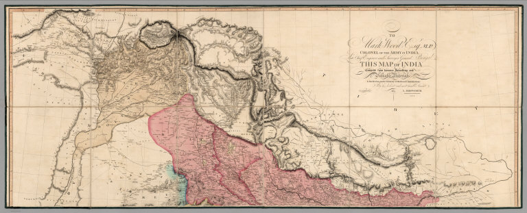
Full Title
(Upper Sheet to) To Mark Wood Esqr. M.P. colonel of the army in India late chief engineer and surveyor general, Bengal this Map of India compiled from various interesting and valuable materials is inscribed in grateful testimony of his liberal communications by ... A. Arrowsmith. London: Published by... A. Arrowsmith, 24 Rathbone Place, 1804.
List No
6732.001
Note
Large and important map of India in six sheets, joined and dissected onto three sheets.It shows British controlled areas at the turn of the century. Arrowsmith published an even larger version of the map in 1816: "With the growing influence of the British in India at the end of the eighteenth century, the need for an up-to-date general map of the sub-continent grew. The first Governor-General, Warren Hastings, employed Major Rennell who, in 1779, published his famous Bengal Atlas, followed up in 1788 by his map of India. The map itself was based upon D'Anville's map of 1752, though enriched by much new material, supplied by the numerous "route surveys" carried out by the army. As these "route surveys" began to become more numerous and accurate the need for a new general map of India soon became apparent. In 1816 Aaron Arrowsmith published his Map of India in nine sheets, on a scale of sixteen miles to an inch, which was the last great general map based on route surveys. His subsequent Atlas of South India, published in 1822, was based upon the trigonometrical surveys of Colonel Lambton, filled in by the officers of the Madras Institute."
Author
Arrowsmith, Aaron
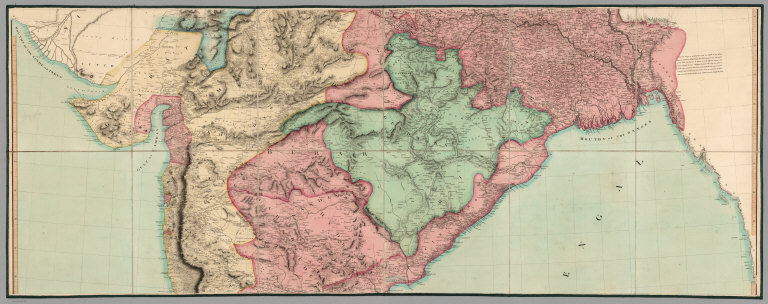
Full Title
(Middle Sheet to) To Mark Wood Esqr. M.P. colonel of the army in India late chief engineer and surveyor general, Bengal this Map of India compiled from various interesting and valuable materials is inscribed in grateful testimony of his liberal communications by ... A. Arrowsmith. London: Published by... A. Arrowsmith, 24 Rathbone Place, 1804.
List No
6732.002
Note
Large and important map of India in six sheets, joined and dissected onto three sheets.It shows British controlled areas at the turn of the century. Arrowsmith published an even larger version of the map in 1816: "With the growing influence of the British in India at the end of the eighteenth century, the need for an up-to-date general map of the sub-continent grew. The first Governor-General, Warren Hastings, employed Major Rennell who, in 1779, published his famous Bengal Atlas, followed up in 1788 by his map of India. The map itself was based upon D'Anville's map of 1752, though enriched by much new material, supplied by the numerous "route surveys" carried out by the army. As these "route surveys" began to become more numerous and accurate the need for a new general map of India soon became apparent. In 1816 Aaron Arrowsmith published his Map of India in nine sheets, on a scale of sixteen miles to an inch, which was the last great general map based on route surveys. His subsequent Atlas of South India, published in 1822, was based upon the trigonometrical surveys of Colonel Lambton, filled in by the officers of the Madras Institute."
Author
Arrowsmith, Aaron
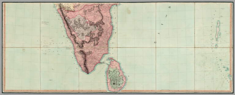
Full Title
(Lower Sheet to) To Mark Wood Esqr. M.P. colonel of the army in India late chief engineer and surveyor general, Bengal this Map of India compiled from various interesting and valuable materials is inscribed in grateful testimony of his liberal communications by ... A. Arrowsmith. London: Published by... A. Arrowsmith, 24 Rathbone Place, 1804.
List No
6732.003
Note
Large and important map of India in six sheets, joined and dissected onto three sheets.It shows British controlled areas at the turn of the century. Arrowsmith published an even larger version of the map in 1816: "With the growing influence of the British in India at the end of the eighteenth century, the need for an up-to-date general map of the sub-continent grew. The first Governor-General, Warren Hastings, employed Major Rennell who, in 1779, published his famous Bengal Atlas, followed up in 1788 by his map of India. The map itself was based upon D'Anville's map of 1752, though enriched by much new material, supplied by the numerous "route surveys" carried out by the army. As these "route surveys" began to become more numerous and accurate the need for a new general map of India soon became apparent. In 1816 Aaron Arrowsmith published his Map of India in nine sheets, on a scale of sixteen miles to an inch, which was the last great general map based on route surveys. His subsequent Atlas of South India, published in 1822, was based upon the trigonometrical surveys of Colonel Lambton, filled in by the officers of the Madras Institute." (Lyon and Turnbull)
Author
Arrowsmith, Aaron
Full Title
(Covers to) To Mark Wood Esqr. M.P. colonel of the army in India late chief engineer and surveyor general, Bengal this Map of India compiled from various interesting and valuable materials is inscribed in grateful testimony of his liberal communications by ... A. Arrowsmith. London: Published by... A. Arrowsmith, 24 Rathbone Place, 1804.
List No
6732.005
Note
Large and important map of India in six sheets, joined and dissected onto three sheets.It shows British controlled areas at the turn of the century. Arrowsmith published an even larger version of the map in 1816: "With the growing influence of the British in India at the end of the eighteenth century, the need for an up-to-date general map of the sub-continent grew. The first Governor-General, Warren Hastings, employed Major Rennell who, in 1779, published his famous Bengal Atlas, followed up in 1788 by his map of India. The map itself was based upon D'Anville's map of 1752, though enriched by much new material, supplied by the numerous "route surveys" carried out by the army. As these "route surveys" began to become more numerous and accurate the need for a new general map of India soon became apparent. In 1816 Aaron Arrowsmith published his Map of India in nine sheets, on a scale of sixteen miles to an inch, which was the last great general map based on route surveys. His subsequent Atlas of South India, published in 1822, was based upon the trigonometrical surveys of Colonel Lambton, filled in by the officers of the Madras Institute."
1-6 of 6
|