|
Author
Arrowsmith, Aaron
Full Title
(Covers to) (Untitled Composite Atlas With Maps Of Spain, Portugal, And Their Dominions In The Americas)
List No
15717.001
Author
[Arrowsmith, Aaron, Lopez de Vargas Machuca, Tomas (1730-1802), Tofino de San Miguel, Vicente, 1732-1795]
Full Title
XII. (Title page) A NEW MILITARY MAP OF SPAIN & PORTUGAL COMPILED FROM THE NAUTICAL SURVEYS OF DON VINCENT TOFINO, THE NEW PROVINCIAL MAPS OF DON TOMAS LOPEZ, THE LARGE MAP OF THE PYRENEES BY ROUSSELL, AND VARIOUS ORIGINAL DOCUMENTS. (London: Re-published by A. Arrowsmith, 10 Soho Square, Hydrographer to His Majesty, [ca. 1820]).
List No
15717.003
Note
Twelve single sheets with contemporary hand coloring, mounted on tabs, which would assemble to form one great 63 x 82” map. With information gathered from a variety of sources, this map contains an extraordinary amount of topographical information as well as the careful delineation of cities, towns, fortified towns, principal villages, villages, and inns. We were unable to find any records for any edition having sold at auction in ABPC or RBH.
Author
Arrowsmith, Aaron
Full Title
(Composite map to) I-XII. A NEW MILITARY MAP OF SPAIN & PORTUGAL COMPILED FROM THE NAUTICAL SURVEYS OF DON VINCENT TOFINO, THE NEW PROVINCIAL MAPS OF DON TOMAS LOPEZ, THE LARGE MAP OF THE PYRENEES BY ROUSSELL, AND VARIOUS ORIGINAL DOCUMENTS. (London: Re-published by A. Arrowsmith, 10 Soho Square, Hydrographer to His Majesty, [ca. 1820]).
List No
15717.015
Note
Twelve single sheets with contemporary hand coloring, mounted on tabs, which would assemble to form one great 63 x 82” map. With information gathered from a variety of sources, this map contains an extraordinary amount of topographical information as well as the careful delineation of cities, towns, fortified towns, principal villages, villages, and inns. We were unable to find any records for any edition having sold at auction in ABPC or RBH.
Author
Arrowsmith, Aaron
Full Title
(Sheet 1) OUTLINES OF THE PHYSICAL AND POLITICAL DIVISIONS OF SOUTH AMERICA . . . PARTLY FROM SCARCE AND ORIGINAL DOCUMENTS, PUBLISHED BEFORE THE YEAR 1806 BUT PRINCIPALLY FROM MANUSCRIPT MAPS & SURVEYS MADE BETWEEN THE YEARS 1771 AND 1806, CORRECTED FROM ACCURATE ASTRONOMICAL OBSERVATIONS TO 1810. (London: Published 4th January 1811 by A. Arrowsmith No. 10 Soho Square, Hydrographer to His Majesty. Additions to 1814, 1817, 1819 [ca. 1820])
List No
15717.016
Note
Compare to our two earlier editions, 2099.000 and 5699.018 to 5699.024. Six double-page sheets mounted on tabs, which would measure 78 x 94 1/2” if joined. This is one of the finest large-scale maps of South America produced in the early 19th century, published during a period of rapid political change during which much of Latin America achieved independence from Spain and Portugal. This appears to be quite rare at auction, with no records having appeared in RBH and ABPC in the past 20 years (and just a handful of copies before that).
Author
Arrowsmith, Aaron
Full Title
(Sheet 2) OUTLINES OF THE PHYSICAL AND POLITICAL DIVISIONS OF SOUTH AMERICA . . . PARTLY FROM SCARCE AND ORIGINAL DOCUMENTS, PUBLISHED BEFORE THE YEAR 1806 BUT PRINCIPALLY FROM MANUSCRIPT MAPS & SURVEYS MADE BETWEEN THE YEARS 1771 AND 1806, CORRECTED FROM ACCURATE ASTRONOMICAL OBSERVATIONS TO 1810. (London: Published 4th January 1811 by A. Arrowsmith No. 10 Soho Square, Hydrographer to His Majesty. Additions to 1814, 1817, 1819 [ca. 1820])
List No
15717.017
Note
Compare to our two earlier editions, 2099.000 and 5699.018 to 5699.024. Six double-page sheets mounted on tabs, which would measure 78 x 94 1/2” if joined. This is one of the finest large-scale maps of South America produced in the early 19th century, published during a period of rapid political change during which much of Latin America achieved independence from Spain and Portugal. This appears to be quite rare at auction, with no records having appeared in RBH and ABPC in the past 20 years (and just a handful of copies before that).
Author
Arrowsmith, Aaron
Full Title
(Sheet 3) OUTLINES OF THE PHYSICAL AND POLITICAL DIVISIONS OF SOUTH AMERICA . . . PARTLY FROM SCARCE AND ORIGINAL DOCUMENTS, PUBLISHED BEFORE THE YEAR 1806 BUT PRINCIPALLY FROM MANUSCRIPT MAPS & SURVEYS MADE BETWEEN THE YEARS 1771 AND 1806, CORRECTED FROM ACCURATE ASTRONOMICAL OBSERVATIONS TO 1810. (London: Published 4th January 1811 by A. Arrowsmith No. 10 Soho Square, Hydrographer to His Majesty. Additions to 1814, 1817, 1819 [ca. 1820])
List No
15717.018
Note
Compare to our two earlier editions, 2099.000 and 5699.018 to 5699.024. Six double-page sheets mounted on tabs, which would measure 78 x 94 1/2” if joined. This is one of the finest large-scale maps of South America produced in the early 19th century, published during a period of rapid political change during which much of Latin America achieved independence from Spain and Portugal. This appears to be quite rare at auction, with no records having appeared in RBH and ABPC in the past 20 years (and just a handful of copies before that).
Author
Arrowsmith, Aaron
Full Title
(Sheet 4) OUTLINES OF THE PHYSICAL AND POLITICAL DIVISIONS OF SOUTH AMERICA . . . PARTLY FROM SCARCE AND ORIGINAL DOCUMENTS, PUBLISHED BEFORE THE YEAR 1806 BUT PRINCIPALLY FROM MANUSCRIPT MAPS & SURVEYS MADE BETWEEN THE YEARS 1771 AND 1806, CORRECTED FROM ACCURATE ASTRONOMICAL OBSERVATIONS TO 1810. (London: Published 4th January 1811 by A. Arrowsmith No. 10 Soho Square, Hydrographer to His Majesty. Additions to 1814, 1817, 1819 [ca. 1820])
List No
15717.019
Note
Compare to our two earlier editions, 2099.000 and 5699.018 to 5699.024. Six double-page sheets mounted on tabs, which would measure 78 x 94 1/2” if joined. This is one of the finest large-scale maps of South America produced in the early 19th century, published during a period of rapid political change during which much of Latin America achieved independence from Spain and Portugal. This appears to be quite rare at auction, with no records having appeared in RBH and ABPC in the past 20 years (and just a handful of copies before that).
Author
Arrowsmith, Aaron
Full Title
(Sheet 5) OUTLINES OF THE PHYSICAL AND POLITICAL DIVISIONS OF SOUTH AMERICA . . . PARTLY FROM SCARCE AND ORIGINAL DOCUMENTS, PUBLISHED BEFORE THE YEAR 1806 BUT PRINCIPALLY FROM MANUSCRIPT MAPS & SURVEYS MADE BETWEEN THE YEARS 1771 AND 1806, CORRECTED FROM ACCURATE ASTRONOMICAL OBSERVATIONS TO 1810. (London: Published 4th January 1811 by A. Arrowsmith No. 10 Soho Square, Hydrographer to His Majesty. Additions to 1814, 1817, 1819 [ca. 1820])
List No
15717.020
Note
Compare to our two earlier editions, 2099.000 and 5699.018 to 5699.024. Six double-page sheets mounted on tabs, which would measure 78 x 94 1/2” if joined. This is one of the finest large-scale maps of South America produced in the early 19th century, published during a period of rapid political change during which much of Latin America achieved independence from Spain and Portugal. This appears to be quite rare at auction, with no records having appeared in RBH and ABPC in the past 20 years (and just a handful of copies before that).
Author
Arrowsmith, Aaron
Full Title
(Sheet 6) OUTLINES OF THE PHYSICAL AND POLITICAL DIVISIONS OF SOUTH AMERICA . . . PARTLY FROM SCARCE AND ORIGINAL DOCUMENTS, PUBLISHED BEFORE THE YEAR 1806 BUT PRINCIPALLY FROM MANUSCRIPT MAPS & SURVEYS MADE BETWEEN THE YEARS 1771 AND 1806, CORRECTED FROM ACCURATE ASTRONOMICAL OBSERVATIONS TO 1810. (London: Published 4th January 1811 by A. Arrowsmith No. 10 Soho Square, Hydrographer to His Majesty. Additions to 1814, 1817, 1819 [ca. 1820])
List No
15717.021
Note
Compare to our two earlier editions, 2099.000 and 5699.018 to 5699.024. Six double-page sheets mounted on tabs, which would measure 78 x 94 1/2” if joined. This is one of the finest large-scale maps of South America produced in the early 19th century, published during a period of rapid political change during which much of Latin America achieved independence from Spain and Portugal. This appears to be quite rare at auction, with no records having appeared in RBH and ABPC in the past 20 years (and just a handful of copies before that).
Author
Arrowsmith, Aaron
Full Title
Composite map to) (Sheets 1-6) OUTLINES OF THE PHYSICAL AND POLITICAL DIVISIONS OF SOUTH AMERICA . . . PARTLY FROM SCARCE AND ORIGINAL DOCUMENTS, PUBLISHED BEFORE THE YEAR 1806 BUT PRINCIPALLY FROM MANUSCRIPT MAPS & SURVEYS MADE BETWEEN THE YEARS 1771 AND 1806, CORRECTED FROM ACCURATE ASTRONOMICAL OBSERVATIONS TO 1810. (London: Published 4th January 1811 by A. Arrowsmith No. 10 Soho Square, Hydrographer to His Majesty. Additions to 1814, 1817, 1819 [ca. 1820])
List No
15717.022
Note
Compare to our two earlier editions, 2099.000 and 5699.018 to 5699.024. Six double-page sheets mounted on tabs, which would measure 78 x 94 1/2” if joined. This is one of the finest large-scale maps of South America produced in the early 19th century, published during a period of rapid political change during which much of Latin America achieved independence from Spain and Portugal. This appears to be quite rare at auction, with no records having appeared in RBH and ABPC in the past 20 years (and just a handful of copies before that).
Author
Arrowsmith, Aaron
Full Title
(Sheet 1) A NEW MAP OF MEXICO AND ADJACENT PROVINCES COMPILED FROM ORIGINAL DOCUMENTS BY A. ARROWSMITH 1810. (London: Published 5th October 1810 by A. Arrowsmith, No. 10 Soho Square, Hydrographer to His Majesty, [but ca. 1820])
List No
15717.023
Note
See our 2035.000 and 2032.000 and 5699.010 to 5699.014 for earlier editions. Four double-page sheets, which would form one 50 1/2 x 62” wall map if assembled. Fifth Edition. Streeter, “Bibliography of Texas” 1046; Phillips, “Maps,” p. 408; Martin & Martin 25. First published in 1810, this is an important depiction of Louisiana and even more important as a cornerstone map of Mexico and the American Southwest. According to Martin & Martin, “By combining the best parts of Humboldt’s and Pike’s maps and avoiding their errors, and by adding his own new information, Arrowsmith contributed a significantly improved depiction of the region.” Although Streeter calls this imprint the first edition, David Rumsey has shown that it was, in fact, printed in 1820 after Arrowsmith began using the title of “Hydrographer to His Majesty.” It also clearly shows the 1819 Adams-Onis Treaty line along the 42nd parallel. As Rumsey notes, “The mystery is why Arrowsmith did not add “additions to 1820” on the title, and in fact erased the “additions to 1817” that must have appeared on the plate from the most recent changes made before the 1820 changes, thereby leaving only 1810 on the title.”
Author
Arrowsmith, Aaron
Full Title
(Sheet 2) A NEW MAP OF MEXICO AND ADJACENT PROVINCES COMPILED FROM ORIGINAL DOCUMENTS BY A. ARROWSMITH 1810. (London: Published 5th October 1810 by A. Arrowsmith, No. 10 Soho Square, Hydrographer to His Majesty, [but ca. 1820])
List No
15717.024
Note
See our 2035.000 and 2032.000 and 5699.010 to 5699.014 for earlier editions. Four double-page sheets, which would form one 50 1/2 x 62” wall map if assembled. Fifth Edition. Streeter, “Bibliography of Texas” 1046; Phillips, “Maps,” p. 408; Martin & Martin 25. First published in 1810, this is an important depiction of Louisiana and even more important as a cornerstone map of Mexico and the American Southwest. According to Martin & Martin, “By combining the best parts of Humboldt’s and Pike’s maps and avoiding their errors, and by adding his own new information, Arrowsmith contributed a significantly improved depiction of the region.” Although Streeter calls this imprint the first edition, David Rumsey has shown that it was, in fact, printed in 1820 after Arrowsmith began using the title of “Hydrographer to His Majesty.” It also clearly shows the 1819 Adams-Onis Treaty line along the 42nd parallel. As Rumsey notes, “The mystery is why Arrowsmith did not add “additions to 1820” on the title, and in fact erased the “additions to 1817” that must have appeared on the plate from the most recent changes made before the 1820 changes, thereby leaving only 1810 on the title.”
Author
Arrowsmith, Aaron
Full Title
(Sheet 3) A NEW MAP OF MEXICO AND ADJACENT PROVINCES COMPILED FROM ORIGINAL DOCUMENTS BY A. ARROWSMITH 1810. (London: Published 5th October 1810 by A. Arrowsmith, No. 10 Soho Square, Hydrographer to His Majesty, [but ca. 1820])
List No
15717.025
Note
See our 2035.000 and 2032.000 and 5699.010 to 5699.014 for earlier editions. Four double-page sheets, which would form one 50 1/2 x 62” wall map if assembled. Fifth Edition. Streeter, “Bibliography of Texas” 1046; Phillips, “Maps,” p. 408; Martin & Martin 25. First published in 1810, this is an important depiction of Louisiana and even more important as a cornerstone map of Mexico and the American Southwest. According to Martin & Martin, “By combining the best parts of Humboldt’s and Pike’s maps and avoiding their errors, and by adding his own new information, Arrowsmith contributed a significantly improved depiction of the region.” Although Streeter calls this imprint the first edition, David Rumsey has shown that it was, in fact, printed in 1820 after Arrowsmith began using the title of “Hydrographer to His Majesty.” It also clearly shows the 1819 Adams-Onis Treaty line along the 42nd parallel. As Rumsey notes, “The mystery is why Arrowsmith did not add “additions to 1820” on the title, and in fact erased the “additions to 1817” that must have appeared on the plate from the most recent changes made before the 1820 changes, thereby leaving only 1810 on the title.”
Author
Arrowsmith, Aaron
Full Title
(Sheet 4) A NEW MAP OF MEXICO AND ADJACENT PROVINCES COMPILED FROM ORIGINAL DOCUMENTS BY A. ARROWSMITH 1810. (London: Published 5th October 1810 by A. Arrowsmith, No. 10 Soho Square, Hydrographer to His Majesty, [but ca. 1820])
List No
15717.026
Note
See our 2035.000 and 2032.000 and 5699.010 to 5699.014 for earlier editions. Four double-page sheets, which would form one 50 1/2 x 62” wall map if assembled. Fifth Edition. Streeter, “Bibliography of Texas” 1046; Phillips, “Maps,” p. 408; Martin & Martin 25. First published in 1810, this is an important depiction of Louisiana and even more important as a cornerstone map of Mexico and the American Southwest. According to Martin & Martin, “By combining the best parts of Humboldt’s and Pike’s maps and avoiding their errors, and by adding his own new information, Arrowsmith contributed a significantly improved depiction of the region.” Although Streeter calls this imprint the first edition, David Rumsey has shown that it was, in fact, printed in 1820 after Arrowsmith began using the title of “Hydrographer to His Majesty.” It also clearly shows the 1819 Adams-Onis Treaty line along the 42nd parallel. As Rumsey notes, “The mystery is why Arrowsmith did not add “additions to 1820” on the title, and in fact erased the “additions to 1817” that must have appeared on the plate from the most recent changes made before the 1820 changes, thereby leaving only 1810 on the title.”
Author
Arrowsmith, Aaron
Full Title
(Composite map to) (Sheets 1-4) A NEW MAP OF MEXICO AND ADJACENT PROVINCES COMPILED FROM ORIGINAL DOCUMENTS BY A. ARROWSMITH 1810. (London: Published 5th October 1810 by A. Arrowsmith, No. 10 Soho Square, Hydrographer to His Majesty, [but ca. 1820])
List No
15717.027
Note
See our 2035.000 and 2032.000 and 5699.010 to 5699.014 for earlier editions. Four double-page sheets, which would form one 50 1/2 x 62” wall map if assembled. Fifth Edition. Streeter, “Bibliography of Texas” 1046; Phillips, “Maps,” p. 408; Martin & Martin 25. First published in 1810, this is an important depiction of Louisiana and even more important as a cornerstone map of Mexico and the American Southwest. According to Martin & Martin, “By combining the best parts of Humboldt’s and Pike’s maps and avoiding their errors, and by adding his own new information, Arrowsmith contributed a significantly improved depiction of the region.” Although Streeter calls this imprint the first edition, David Rumsey has shown that it was, in fact, printed in 1820 after Arrowsmith began using the title of “Hydrographer to His Majesty.” It also clearly shows the 1819 Adams-Onis Treaty line along the 42nd parallel. As Rumsey notes, “The mystery is why Arrowsmith did not add “additions to 1820” on the title, and in fact erased the “additions to 1817” that must have appeared on the plate from the most recent changes made before the 1820 changes, thereby leaving only 1810 on the title.”
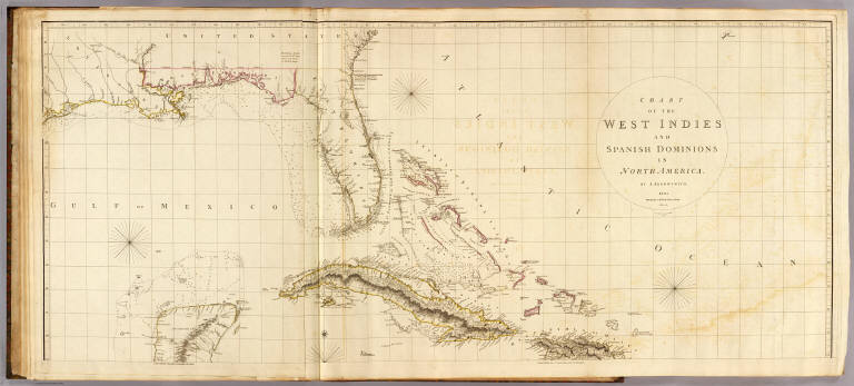
Author
Arrowsmith, Aaron
Full Title
(Sheet 1) CHART OF THE WEST INDIES AND SPANISH DOMINIONS IN NORTH AMERICA. (London: Published June 1st 1803 by A. Arrowsmith No. 10 Soho Square. With Additions to 1810, [probably ca. 1820])
List No
15717.028
Note
See our 5699.015-5699.017 and 4121.000 for earlier editions. This was one of the best available large-scale maps of Louisiana, Florida, and especially the West Indies in the early 19th century, rendered with excellent detail (particularly for Mexico). It includes interesting historical details, such as the locations of “Canals proposed to be cut by the Spaniards in 1528.” Although the imprint on this copy says that the map contains additions to 1810 (which would indicate that this is a second edition), we see that Arrowsmith here uses the title of “Hydrographer to His Majesty,” which, as noted above, was used by the cartographer from 1820 onward. Our copy also includes an inset of the Isthmus of Darien, which is not found on other copies of the second edition. Rumsey tells us that “Stevens and Tree only list two editions, 1803 and 1810, but Phillips lists an 1811 (P-Maps) and an 1816 (atlases). There probably were others.” (Pirages, 2023)
Author
Arrowsmith, Aaron
Full Title
(Sheet 2) CHART OF THE WEST INDIES AND SPANISH DOMINIONS IN NORTH AMERICA. (London: Published June 1st 1803 by A. Arrowsmith No. 10 Soho Square. With Additions to 1810, [probably ca. 1820])
List No
15717.029
Note
See our 5699.015-5699.017 and 4121.000 for earlier editions. This was one of the best available large-scale maps of Louisiana, Florida, and especially the West Indies in the early 19th century, rendered with excellent detail (particularly for Mexico). It includes interesting historical details, such as the locations of “Canals proposed to be cut by the Spaniards in 1528.” Although the imprint on this copy says that the map contains additions to 1810 (which would indicate that this is a second edition), we see that Arrowsmith here uses the title of “Hydrographer to His Majesty,” which, as noted above, was used by the cartographer from 1820 onward. Our copy also includes an inset of the Isthmus of Darien, which is not found on other copies of the second edition. Rumsey tells us that “Stevens and Tree only list two editions, 1803 and 1810, but Phillips lists an 1811 (P-Maps) and an 1816 (atlases). There probably were others.” (Pirages, 2023)
Author
Arrowsmith, Aaron
Full Title
(Sheet 3) CHART OF THE WEST INDIES AND SPANISH DOMINIONS IN NORTH AMERICA. (London: Published June 1st 1803 by A. Arrowsmith No. 10 Soho Square. With Additions to 1810, [probably ca. 1820])
List No
15717.030
Note
See our 5699.015-5699.017 and 4121.000 for earlier editions. This was one of the best available large-scale maps of Louisiana, Florida, and especially the West Indies in the early 19th century, rendered with excellent detail (particularly for Mexico). It includes interesting historical details, such as the locations of “Canals proposed to be cut by the Spaniards in 1528.” Although the imprint on this copy says that the map contains additions to 1810 (which would indicate that this is a second edition), we see that Arrowsmith here uses the title of “Hydrographer to His Majesty,” which, as noted above, was used by the cartographer from 1820 onward. Our copy also includes an inset of the Isthmus of Darien, which is not found on other copies of the second edition. Rumsey tells us that “Stevens and Tree only list two editions, 1803 and 1810, but Phillips lists an 1811 (P-Maps) and an 1816 (atlases). There probably were others.” (Pirages, 2023)
Author
Arrowsmith, Aaron
Full Title
(Sheet 4) CHART OF THE WEST INDIES AND SPANISH DOMINIONS IN NORTH AMERICA. (London: Published June 1st 1803 by A. Arrowsmith No. 10 Soho Square. With Additions to 1810, [probably ca. 1820])
List No
15717.031
Note
See our 5699.015-5699.017 and 4121.000 for earlier editions. This was one of the best available large-scale maps of Louisiana, Florida, and especially the West Indies in the early 19th century, rendered with excellent detail (particularly for Mexico). It includes interesting historical details, such as the locations of “Canals proposed to be cut by the Spaniards in 1528.” Although the imprint on this copy says that the map contains additions to 1810 (which would indicate that this is a second edition), we see that Arrowsmith here uses the title of “Hydrographer to His Majesty,” which, as noted above, was used by the cartographer from 1820 onward. Our copy also includes an inset of the Isthmus of Darien, which is not found on other copies of the second edition. Rumsey tells us that “Stevens and Tree only list two editions, 1803 and 1810, but Phillips lists an 1811 (P-Maps) and an 1816 (atlases). There probably were others.” (Pirages, 2023)
Author
Arrowsmith, Aaron
Full Title
(Composite map to) (Sheets 1-4) CHART OF THE WEST INDIES AND SPANISH DOMINIONS IN NORTH AMERICA. (London: Published June 1st 1803 by A. Arrowsmith No. 10 Soho Square. With Additions to 1810, [probably ca. 1820])
List No
15717.032
Note
See our 5699.015-5699.017 and 4121.000 for earlier editions. This was one of the best available large-scale maps of Louisiana, Florida, and especially the West Indies in the early 19th century, rendered with excellent detail (particularly for Mexico). It includes interesting historical details, such as the locations of “Canals proposed to be cut by the Spaniards in 1528.” Although the imprint on this copy says that the map contains additions to 1810 (which would indicate that this is a second edition), we see that Arrowsmith here uses the title of “Hydrographer to His Majesty,” which, as noted above, was used by the cartographer from 1820 onward. Our copy also includes an inset of the Isthmus of Darien, which is not found on other copies of the second edition. Rumsey tells us that “Stevens and Tree only list two editions, 1803 and 1810, but Phillips lists an 1811 (P-Maps) and an 1816 (atlases). There probably were others.” (Pirages, 2023)
Author
Arrowsmith, Aaron
Full Title
(Text pages to) (armorial bookplate of Heytesbury House)
List No
15717.002
Note
Front pastedown with armorial bookplate of Heytesbury House; upper cover with inked name “Sir Will[ia]m a’Court B[arone]t” in a contemporary hand.
Author
[Arrowsmith, Aaron, Lopez de Vargas Machuca, Tomas (1730-1802), Tofino de San Miguel, Vicente, 1732-1795]
Full Title
I. A NEW MILITARY MAP OF SPAIN & PORTUGAL COMPILED FROM THE NAUTICAL SURVEYS OF DON VINCENT TOFINO, THE NEW PROVINCIAL MAPS OF DON TOMAS LOPEZ, THE LARGE MAP OF THE PYRENEES BY ROUSSELL, AND VARIOUS ORIGINAL DOCUMENTS. (London: Re-published by A. Arrowsmith, 10 Soho Square, Hydrographer to His Majesty, [ca. 1820]).
List No
15717.004
Note
Twelve single sheets with contemporary hand coloring, mounted on tabs, which would assemble to form one great 63 x 82” map. With information gathered from a variety of sources, this map contains an extraordinary amount of topographical information as well as the careful delineation of cities, towns, fortified towns, principal villages, villages, and inns. We were unable to find any records for any edition having sold at auction in ABPC or RBH.
Author
[Arrowsmith, Aaron, Lopez de Vargas Machuca, Tomas (1730-1802), Tofino de San Miguel, Vicente, 1732-1795]
Full Title
II. A NEW MILITARY MAP OF SPAIN & PORTUGAL COMPILED FROM THE NAUTICAL SURVEYS OF DON VINCENT TOFINO, THE NEW PROVINCIAL MAPS OF DON TOMAS LOPEZ, THE LARGE MAP OF THE PYRENEES BY ROUSSELL, AND VARIOUS ORIGINAL DOCUMENTS. (London: Re-published by A. Arrowsmith, 10 Soho Square, Hydrographer to His Majesty, [ca. 1820]).
List No
15717.005
Note
Twelve single sheets with contemporary hand coloring, mounted on tabs, which would assemble to form one great 63 x 82” map. With information gathered from a variety of sources, this map contains an extraordinary amount of topographical information as well as the careful delineation of cities, towns, fortified towns, principal villages, villages, and inns. We were unable to find any records for any edition having sold at auction in ABPC or RBH.
Author
[Arrowsmith, Aaron, Lopez de Vargas Machuca, Tomas (1730-1802), Tofino de San Miguel, Vicente, 1732-1795]
Full Title
III. A NEW MILITARY MAP OF SPAIN & PORTUGAL COMPILED FROM THE NAUTICAL SURVEYS OF DON VINCENT TOFINO, THE NEW PROVINCIAL MAPS OF DON TOMAS LOPEZ, THE LARGE MAP OF THE PYRENEES BY ROUSSELL, AND VARIOUS ORIGINAL DOCUMENTS. (London: Re-published by A. Arrowsmith, 10 Soho Square, Hydrographer to His Majesty, [ca. 1820]).
List No
15717.006
Note
Twelve single sheets with contemporary hand coloring, mounted on tabs, which would assemble to form one great 63 x 82” map. With information gathered from a variety of sources, this map contains an extraordinary amount of topographical information as well as the careful delineation of cities, towns, fortified towns, principal villages, villages, and inns. We were unable to find any records for any edition having sold at auction in ABPC or RBH.
Author
[Arrowsmith, Aaron, Lopez de Vargas Machuca, Tomas (1730-1802), Tofino de San Miguel, Vicente, 1732-1795]
Full Title
IV. A NEW MILITARY MAP OF SPAIN & PORTUGAL COMPILED FROM THE NAUTICAL SURVEYS OF DON VINCENT TOFINO, THE NEW PROVINCIAL MAPS OF DON TOMAS LOPEZ, THE LARGE MAP OF THE PYRENEES BY ROUSSELL, AND VARIOUS ORIGINAL DOCUMENTS. (London: Re-published by A. Arrowsmith, 10 Soho Square, Hydrographer to His Majesty, [ca. 1820]).
List No
15717.007
Note
Twelve single sheets with contemporary hand coloring, mounted on tabs, which would assemble to form one great 63 x 82” map. With information gathered from a variety of sources, this map contains an extraordinary amount of topographical information as well as the careful delineation of cities, towns, fortified towns, principal villages, villages, and inns. We were unable to find any records for any edition having sold at auction in ABPC or RBH.
Author
[Arrowsmith, Aaron, Lopez de Vargas Machuca, Tomas (1730-1802), Tofino de San Miguel, Vicente, 1732-1795]
Full Title
V. A NEW MILITARY MAP OF SPAIN & PORTUGAL COMPILED FROM THE NAUTICAL SURVEYS OF DON VINCENT TOFINO, THE NEW PROVINCIAL MAPS OF DON TOMAS LOPEZ, THE LARGE MAP OF THE PYRENEES BY ROUSSELL, AND VARIOUS ORIGINAL DOCUMENTS. (London: Re-published by A. Arrowsmith, 10 Soho Square, Hydrographer to His Majesty, [ca. 1820]).
List No
15717.008
Note
Twelve single sheets with contemporary hand coloring, mounted on tabs, which would assemble to form one great 63 x 82” map. With information gathered from a variety of sources, this map contains an extraordinary amount of topographical information as well as the careful delineation of cities, towns, fortified towns, principal villages, villages, and inns. We were unable to find any records for any edition having sold at auction in ABPC or RBH.
Author
[Arrowsmith, Aaron, Lopez de Vargas Machuca, Tomas (1730-1802), Tofino de San Miguel, Vicente, 1732-1795]
Full Title
VI. A NEW MILITARY MAP OF SPAIN & PORTUGAL COMPILED FROM THE NAUTICAL SURVEYS OF DON VINCENT TOFINO, THE NEW PROVINCIAL MAPS OF DON TOMAS LOPEZ, THE LARGE MAP OF THE PYRENEES BY ROUSSELL, AND VARIOUS ORIGINAL DOCUMENTS. (London: Re-published by A. Arrowsmith, 10 Soho Square, Hydrographer to His Majesty, [ca. 1820]).
List No
15717.009
Note
Twelve single sheets with contemporary hand coloring, mounted on tabs, which would assemble to form one great 63 x 82” map. With information gathered from a variety of sources, this map contains an extraordinary amount of topographical information as well as the careful delineation of cities, towns, fortified towns, principal villages, villages, and inns. We were unable to find any records for any edition having sold at auction in ABPC or RBH.
Author
[Arrowsmith, Aaron, Lopez de Vargas Machuca, Tomas (1730-1802), Tofino de San Miguel, Vicente, 1732-1795]
Full Title
VII. A NEW MILITARY MAP OF SPAIN & PORTUGAL COMPILED FROM THE NAUTICAL SURVEYS OF DON VINCENT TOFINO, THE NEW PROVINCIAL MAPS OF DON TOMAS LOPEZ, THE LARGE MAP OF THE PYRENEES BY ROUSSELL, AND VARIOUS ORIGINAL DOCUMENTS. (London: Re-published by A. Arrowsmith, 10 Soho Square, Hydrographer to His Majesty, [ca. 1820]).
List No
15717.010
Note
Twelve single sheets with contemporary hand coloring, mounted on tabs, which would assemble to form one great 63 x 82” map. With information gathered from a variety of sources, this map contains an extraordinary amount of topographical information as well as the careful delineation of cities, towns, fortified towns, principal villages, villages, and inns. We were unable to find any records for any edition having sold at auction in ABPC or RBH.
Author
[Arrowsmith, Aaron, Lopez de Vargas Machuca, Tomas (1730-1802), Tofino de San Miguel, Vicente, 1732-1795]
Full Title
VIII. A NEW MILITARY MAP OF SPAIN & PORTUGAL COMPILED FROM THE NAUTICAL SURVEYS OF DON VINCENT TOFINO, THE NEW PROVINCIAL MAPS OF DON TOMAS LOPEZ, THE LARGE MAP OF THE PYRENEES BY ROUSSELL, AND VARIOUS ORIGINAL DOCUMENTS. (London: Re-published by A. Arrowsmith, 10 Soho Square, Hydrographer to His Majesty, [ca. 1820]).
List No
15717.011
Note
Twelve single sheets with contemporary hand coloring, mounted on tabs, which would assemble to form one great 63 x 82” map. With information gathered from a variety of sources, this map contains an extraordinary amount of topographical information as well as the careful delineation of cities, towns, fortified towns, principal villages, villages, and inns. We were unable to find any records for any edition having sold at auction in ABPC or RBH.
Author
[Arrowsmith, Aaron, Lopez de Vargas Machuca, Tomas (1730-1802), Tofino de San Miguel, Vicente, 1732-1795]
Full Title
IX. A NEW MILITARY MAP OF SPAIN & PORTUGAL COMPILED FROM THE NAUTICAL SURVEYS OF DON VINCENT TOFINO, THE NEW PROVINCIAL MAPS OF DON TOMAS LOPEZ, THE LARGE MAP OF THE PYRENEES BY ROUSSELL, AND VARIOUS ORIGINAL DOCUMENTS. (London: Re-published by A. Arrowsmith, 10 Soho Square, Hydrographer to His Majesty, [ca. 1820]).
List No
15717.012
Note
Twelve single sheets with contemporary hand coloring, mounted on tabs, which would assemble to form one great 63 x 82” map. With information gathered from a variety of sources, this map contains an extraordinary amount of topographical information as well as the careful delineation of cities, towns, fortified towns, principal villages, villages, and inns. We were unable to find any records for any edition having sold at auction in ABPC or RBH.
Author
[Arrowsmith, Aaron, Lopez de Vargas Machuca, Tomas (1730-1802), Tofino de San Miguel, Vicente, 1732-1795]
Full Title
X. A NEW MILITARY MAP OF SPAIN & PORTUGAL COMPILED FROM THE NAUTICAL SURVEYS OF DON VINCENT TOFINO, THE NEW PROVINCIAL MAPS OF DON TOMAS LOPEZ, THE LARGE MAP OF THE PYRENEES BY ROUSSELL, AND VARIOUS ORIGINAL DOCUMENTS. (London: Re-published by A. Arrowsmith, 10 Soho Square, Hydrographer to His Majesty, [ca. 1820]).
List No
15717.013
Note
Twelve single sheets with contemporary hand coloring, mounted on tabs, which would assemble to form one great 63 x 82” map. With information gathered from a variety of sources, this map contains an extraordinary amount of topographical information as well as the careful delineation of cities, towns, fortified towns, principal villages, villages, and inns. We were unable to find any records for any edition having sold at auction in ABPC or RBH.
Author
[Arrowsmith, Aaron, Lopez de Vargas Machuca, Tomas (1730-1802), Tofino de San Miguel, Vicente, 1732-1795]
Full Title
XI. A NEW MILITARY MAP OF SPAIN & PORTUGAL COMPILED FROM THE NAUTICAL SURVEYS OF DON VINCENT TOFINO, THE NEW PROVINCIAL MAPS OF DON TOMAS LOPEZ, THE LARGE MAP OF THE PYRENEES BY ROUSSELL, AND VARIOUS ORIGINAL DOCUMENTS. (London: Re-published by A. Arrowsmith, 10 Soho Square, Hydrographer to His Majesty, [ca. 1820]).
List No
15717.014
Note
Twelve single sheets with contemporary hand coloring, mounted on tabs, which would assemble to form one great 63 x 82” map. With information gathered from a variety of sources, this map contains an extraordinary amount of topographical information as well as the careful delineation of cities, towns, fortified towns, principal villages, villages, and inns. We were unable to find any records for any edition having sold at auction in ABPC or RBH.
Author
[Alcedo, Antonio de, 1735-1812, Arrowsmith, Aaron, Thompson, George Alexander]
Full Title
(Covers to) Atlas to Thompson's Alcedo; or dictionary of America & West Indies; collated with all the most recent authorities, and composed chiefly from scarce and original documents, for that work, by A. Arrowsmith, Hydrographer to His Royal Highness the Prince Regent. London: Printed by George Smeeton, Great Saint Martin's Lane, Charing Cross. 1819.
List No
5699A
Author
[Alcedo, Antonio de, 1735-1812, Arrowsmith, Aaron, Thompson, George Alexander]
Full Title
(Index to) Atlas to Thompson's Alcedo; or dictionary of America & West Indies; collated with all the most recent authorities, and composed chiefly from scarce and original documents, for that work, by A. Arrowsmith, Hydrographer to His Royal Highness the Prince Regent. London: Printed by George Smeeton, Great Saint Martin's Lane, Charing Cross. 1819.
List No
5699B
Note
Diagram showing the arrangement of the 19 sheets comprising the five maps. "Atlas to Thompson's Alcedo; or dictionary of America and West Indies by Arrowsmith. Index."
Author
[Alcedo, Antonio de, 1735-1812, Arrowsmith, Aaron, Thompson, George Alexander]
Full Title
(Title Page to) Atlas to Thompson's Alcedo; or dictionary of America & West Indies; collated with all the most recent authorities, and composed chiefly from scarce and original documents, for that work, by A. Arrowsmith, Hydrographer to His Royal Highness the Prince Regent. London: Printed by George Smeeton, Great Saint Martin's Lane, Charing Cross. 1819.
List No
5699C
Author
Arrowsmith, Aaron
Full Title
A map exhibiting all the new discoveries in the interior parts of North America, inscribed by permission to the Honorable Governor and Company of Adventurers of England trading into Hudson Bay, in testimony of their liberal communications to their most obedient and very humble servant, A. Arrowsmith, Hydrographer to H.R.H. the Prince of Wales. (Sheet 1). No. 10 Soho Square. January 1st, 1795 -- additions to 1811, 1818.
List No
5699.001
Note
Engraved map. Hand col. Relief shown by hachures. Sheet 1 of 3. Shows settlements, Indian tribes, rivers, etc. In lower margin: London, Published 1 Jan. 1795 by A. Arrowsmith ... additions to 1802. Below title: Additions to June 1814. Printed on 2 sheets, joined together.
Author
Arrowsmith, Aaron
Full Title
(A map exhibiting all the new discoveries in the interior parts of North America, inscribed by permission to the Honorable Governor and Company of Adventurers of England trading into Hudson Bay, in testimony of their liberal communications to their most obedient and very humble servant, A. Arrowsmith, Hydrographer to H.R.H. the Prince of Wales. Sheet 2.) London: Published Jan. 1, 1795 by A. Arrowsmith, No. 10 Soho Square -- additions to 1802. (1818)
List No
5699.002
Note
Engraved map. Hand col. Relief shown by hachures. Sheet 2 of 3. Shows settlements, Indian tribes, rivers, etc. Printed on 2 sheets, joined together.
Author
Arrowsmith, Aaron
Full Title
(A map exhibiting all the new discoveries in the interior parts of North America, inscribed by permission to the Honorable Governor and Company of Adventurers of England trading into Hudson Bay, in testimony of their liberal communications to their most obedient and very humble servant, A. Arrowsmith, Hydrographer to H.R.H. the Prince of Wales. Sheet 3.) London: Published 1 Jan. 1795 by A. Arrowsmith, No. 10 Soho Square -- additions to 1802. (1818)
List No
5699.003
Note
Engraved map. Hand col. Relief shown by hachures. Sheet 3 of 3. Shows settlements, Indian tribes, rivers, etc. Printed on 2 sheets, joined together.
Author
Arrowsmith, Aaron
Full Title
(Composite of) A map exhibiting all the new discoveries in the interior parts of North America, inscribed by permission to the Honorable Governor and Company of Adventurers of England trading into Hudson Bay, in testimony of their liberal communications to their most obedient and very humble servant, A. Arrowsmith, Hydrographer to H.R.H. the Prince of Wales. No. 10 Soho Square. January 1st, 1795 -- additions to 1811, 1818.
List No
5699.004
Note
Engraved map on 3 sheets. Hand col. Relief shown by hachures. Shows settlements, Indian tribes, rivers, etc. In lower margin: London, Published 1 Jan. 1795 by A. Arrowsmith ... additions to 1802. Below title: Additions to June 1814. Printed on 6 sheets, joined together as 3.
Author
Arrowsmith, Aaron
Full Title
A map of the United States of North America. Drawn from a number of critical researches by A. Arrowsmith, Hydrographer to H.R.H. the Prince of Wales. (Sheet 1). No. 10 Soho Square. London, Published as the Act directs by A. Arrowsmith, no. 10 Soho Square -- Jan. 1st, 1796, additions to 1802.
List No
5699.005
Note
Engraved map. Outline hand col. Relief shown by pictorially and by hachures. Sheet 1 of 4. Shows settlements, roads with distances, Indian tribes, rivers, etc. Title in cartouche with large illustration of "Falls of Niagara" that includes text.
Author
Arrowsmith, Aaron
Full Title
(A map of the United States of North America. Drawn from a number of critical researches by A. Arrowsmith, Hydrographer to H.R.H. the Prince of Wales. Sheet 2). London, Published as the Act directs by A. Arrowsmith, no. 10 Soho Square -- Jan. 1st, 1796, additions to 1802.
List No
5699.006
Note
Engraved map. Outline hand col. Relief shown by pictorially and by hachures. Sheet 2 of 4. Shows settlements, roads with distances, Indian tribes, rivers, etc.
Author
Arrowsmith, Aaron
Full Title
(A map of the United States of North America. Drawn from a number of critical researches by A. Arrowsmith, Hydrographer to H.R.H. the Prince of Wales. Sheet 3). London, Published as the Act directs by A. Arrowsmith, no. 10 Soho Square. (1802).
List No
5699.007
Note
Engraved map. Outline hand col. Relief shown by pictorially and by hachures. Sheet 3 of 4. Shows settlements, roads with distances, Indian tribes, rivers, etc.
Author
Arrowsmith, Aaron
Full Title
(A map of the United States of North America. Drawn from a number of critical researches by A. Arrowsmith, Hydrographer to H.R.H. the Prince of Wales. Sheet 4). London, Published as the Act directs by A. Arrowsmith, no. 10 Soho Square -- Jan. 1st, 1796, additions to 1802.
List No
5699.008
Note
Engraved map. Outline hand col. Relief shown by pictorially and by hachures. Sheet 3 of 4. Shows settlements, roads with distances, Indian tribes, rivers, etc.
Author
Arrowsmith, Aaron
Full Title
(Composite of) A map of the United States of North America. Drawn from a number of critical researches by A. Arrowsmith, Hydrographer to H.R.H. the Prince of Wales. No. 10 Soho Square. London, Published as the Act directs by A. Arrowsmith, no. 10 Soho Square -- Jan. 1st, 1796, additions to 1802.
List No
5699.009
Note
Engraved map on 4 sheets. Outline hand col. Relief shown by pictorially and by hachures. Shows settlements, roads with distances, Indian tribes, rivers, etc. Title in cartouche with large illustration of "Falls of Niagara" that includes text.
Author
[Arrowsmith, Aaron, Humboldt, Alexander von, 1769-1859]
Full Title
A new map of Mexico and adjacent provinces compiled from original documents by A. Arrowsmith, 1810. (Sheet 1). (with) Valley of Mexico, from Mr. Humboldt's map. London, Published 5th October 1810 by A. Arrowsmith, 10 Soho Squ(ar)e, Hydrographer to H.R.H. the Prince of Wales. Engraved by E. Jones.
List No
5699.010
Note
Engraved map. Outline hand col. Relief shown by hachures. Sheet 1 of 4. Shows settlements, roads, Indian tribes, rivers, etc. Scale of inset (ca. 1:363,000)
Author
[Arrowsmith, Aaron, Humboldt, Alexander von, 1769-1859]
Full Title
(A new map of Mexico and adjacent provinces compiled from original documents by A. Arrowsmith, 1810. Sheet 2). (with) Veracruz. (with) Acapulco. London, Published 5th October 1810 by A. Arrowsmith, 10 Soho Square. (Engraved by E. Jones)
List No
5699.011
Note
Engraved map. Outline hand col. Relief shown by hachures. Sheet 2 of 4. Shows settlements, roads, Indian tribes, rivers, etc.
Author
[Arrowsmith, Aaron, Humboldt, Alexander von, 1769-1859]
Full Title
(A new map of Mexico and adjacent provinces compiled from original documents by A. Arrowsmith, 1810. Sheet 3). London, Published 5th October 1810 by A. Arrowsmith, 10 Soho Square. (Engraved by E. Jones)
List No
5699.012
Note
Engraved map. Outline hand col. Relief shown by hachures. Sheet 3 of 4. Shows settlements, roads, Indian tribes, rivers, etc. Covers "New Albion" and parts of the Southwest.
Author
[Arrowsmith, Aaron, Humboldt, Alexander von, 1769-1859]
Full Title
(A new map of Mexico and adjacent provinces compiled from original documents by A. Arrowsmith, 1810. Sheet 4). London, Published 5th October 1810 by A. Arrowsmith, 10 Soho Square. (Engraved by E. Jones)
List No
5699.013
Note
Engraved map. Outline hand col. Relief shown by hachures. Sheet 4 of 4. Shows settlements, roads, Indian tribes, rivers, etc. Covers parts of the Southwestern U.S.
Author
[Arrowsmith, Aaron, Humboldt, Alexander von, 1769-1859]
Full Title
(Composite of) A new map of Mexico and adjacent provinces compiled from original documents by A. Arrowsmith, 1810. (with) Valley of Mexico, from Mr. Humboldt's map. (with) Veracruz. (with) Acapulco. London, Published 5th October 1810 by A. Arrowsmith, 10 Soho Square, Hydrographer to H.R.H. the Prince of Wales. Engraved by E. Jones.
List No
5699.014
Note
Engraved map on 4 sheets. Outline hand col. Relief shown by hachures. Shows settlements, roads, Indian tribes, rivers, etc. Scale of Valley of Mexico inset (ca. 1:363,000)
Author
Arrowsmith, Aaron
Full Title
Chart of the West Indies and Spanish Dominions in North America. (Sheet 1). By A. Arrowsmith. 1803. Hydrographer to H.R.H. the Prince of Wales. Additions to 1810. London, Published June 1st, 1803 by A. Arrowsmith, 10 Soho Square. Jones, Smith & Co. sc., Beaufort Buildgs., Strand.
List No
5699.015
Note
Engraved map. Outline hand col. Relief shown by hachures; depths by soundings. Sheet 1 of 2. Shows settlements, roads, rivers, etc. Includes descriptive notes. Printed on 2 sheets, joined together.
|