|
REFINE
Browse All : Images by Arrowsmith, Aaron and A. Arrowsmith from 1819
1-35 of 35
Author
Arrowsmith, Aaron
Full Title
(C0vers to) A Map Of The United States of North America Drawn from a number of Critical Researches By A. Arrowsmith, Hydrographer to His Majesty. No. 10 Soho Square. Additions to 1819. London. Published as the Act Directs by A. Arrowsmith, No. 10 Soho Square. Jan 1st, 1796. Additions to 1802 ... (inset map of Florida).
List No
3445A
Note
The last edition, with the "wings" on the Mississippi and the Northwest. Adds Illinois, Indiana, Ohio, Michigan, Louisiana, Mississippi and Missouri Territory. Many changes to the topography as well. An inset of the Florida Peninsula appears. The northern wing shows the Lake of the Woods and the southern wing shows the mouths of the Mississippi in detail. The delineation of the roads indicates that Bradley's Postal Map of the U.S. may have been used as a source. Outline color by state. Map is in four sheets, each dissected into 12 sections. Sheets fold into a new slip case 26x18 with the original tan covers pasted down with a label reading "J. Le Nesuvier (645) United States" in manuscript.
Author
Arrowsmith, Aaron
Full Title
A Map Of The United States of North America Drawn from a number of Critical Researches By A. Arrowsmith, Hydrographer to His Majesty. No. 10 Soho Square. Additions to 1819. London. Published as the Act Directs by A. Arrowsmith, No. 10 Soho Square. Jan 1st, 1796. Additions to 1802 ... (inset map of Florida).
List No
3445.001
Note
The last edition, with the "wings" on the Mississippi and the Northwest. Adds Illinois, Indiana, Ohio, Michigan, Louisiana, Mississippi and Missouri Territory. Many changes to the topography as well. An inset of the Florida Peninsula appears. The northern wing shows the Lake of the Woods and the southern wing shows the mouths of the Mississippi in detail. The delineation of the roads indicates that Bradley's Postal Map of the U.S. may have been used as a source. Outline color by state. Map is in four sheets, each dissected into 12 sections. Sheets fold into a new slip case 26x18 with the original tan covers pasted down with a label reading "J. Le Nesuvier (645) United States" in manuscript.
Author
Arrowsmith, Aaron
Full Title
A Map of the United States of North America Drawn from a number of Critical Researches ... Additions to 1819 (Western two sheets only). London, Published by A. Arrowsmith, No. 10 Soho Square Jan 1st 1796.
List No
4309.000
Note
Lacking the two eastern sheets which include the title. This issue is earlier slightly than our complete 1819 edition (Stevens 79 (i)) with less development shown in the area around the junction of the Ohio and Wabash Rivers, which were settling up rapidly at that time (see David Thomas "Travels Through The Western Country"). However, it has the northern and (most of) the southern flaps which place it later than Stevens 79 (h). So it is probably an unrecorded state of the map. Map has light blue silk edging, is dissected into 25 sections, and folds into a new blue cloth folding case 26x17 with "United States A. Arrowsmith 1819" stamped in gilt on the spine.
Author
Arrowsmith, Aaron
Full Title
A map exhibiting all the new discoveries in the interior parts of North America, inscribed by permission to the Honorable Governor and Company of Adventurers of England trading into Hudson Bay, in testimony of their liberal communications to their most obedient and very humble servant, A. Arrowsmith, Hydrographer to H.R.H. the Prince of Wales. (Sheet 1). No. 10 Soho Square. January 1st, 1795 -- additions to 1811, 1818.
List No
5699.001
Note
Engraved map. Hand col. Relief shown by hachures. Sheet 1 of 3. Shows settlements, Indian tribes, rivers, etc. In lower margin: London, Published 1 Jan. 1795 by A. Arrowsmith ... additions to 1802. Below title: Additions to June 1814. Printed on 2 sheets, joined together.
Author
Arrowsmith, Aaron
Full Title
(A map exhibiting all the new discoveries in the interior parts of North America, inscribed by permission to the Honorable Governor and Company of Adventurers of England trading into Hudson Bay, in testimony of their liberal communications to their most obedient and very humble servant, A. Arrowsmith, Hydrographer to H.R.H. the Prince of Wales. Sheet 2.) London: Published Jan. 1, 1795 by A. Arrowsmith, No. 10 Soho Square -- additions to 1802. (1818)
List No
5699.002
Note
Engraved map. Hand col. Relief shown by hachures. Sheet 2 of 3. Shows settlements, Indian tribes, rivers, etc. Printed on 2 sheets, joined together.
Author
Arrowsmith, Aaron
Full Title
(A map exhibiting all the new discoveries in the interior parts of North America, inscribed by permission to the Honorable Governor and Company of Adventurers of England trading into Hudson Bay, in testimony of their liberal communications to their most obedient and very humble servant, A. Arrowsmith, Hydrographer to H.R.H. the Prince of Wales. Sheet 3.) London: Published 1 Jan. 1795 by A. Arrowsmith, No. 10 Soho Square -- additions to 1802. (1818)
List No
5699.003
Note
Engraved map. Hand col. Relief shown by hachures. Sheet 3 of 3. Shows settlements, Indian tribes, rivers, etc. Printed on 2 sheets, joined together.
Author
Arrowsmith, Aaron
Full Title
(Composite of) A map exhibiting all the new discoveries in the interior parts of North America, inscribed by permission to the Honorable Governor and Company of Adventurers of England trading into Hudson Bay, in testimony of their liberal communications to their most obedient and very humble servant, A. Arrowsmith, Hydrographer to H.R.H. the Prince of Wales. No. 10 Soho Square. January 1st, 1795 -- additions to 1811, 1818.
List No
5699.004
Note
Engraved map on 3 sheets. Hand col. Relief shown by hachures. Shows settlements, Indian tribes, rivers, etc. In lower margin: London, Published 1 Jan. 1795 by A. Arrowsmith ... additions to 1802. Below title: Additions to June 1814. Printed on 6 sheets, joined together as 3.
Author
Arrowsmith, Aaron
Full Title
A map of the United States of North America. Drawn from a number of critical researches by A. Arrowsmith, Hydrographer to H.R.H. the Prince of Wales. (Sheet 1). No. 10 Soho Square. London, Published as the Act directs by A. Arrowsmith, no. 10 Soho Square -- Jan. 1st, 1796, additions to 1802.
List No
5699.005
Note
Engraved map. Outline hand col. Relief shown by pictorially and by hachures. Sheet 1 of 4. Shows settlements, roads with distances, Indian tribes, rivers, etc. Title in cartouche with large illustration of "Falls of Niagara" that includes text.
Author
Arrowsmith, Aaron
Full Title
(A map of the United States of North America. Drawn from a number of critical researches by A. Arrowsmith, Hydrographer to H.R.H. the Prince of Wales. Sheet 2). London, Published as the Act directs by A. Arrowsmith, no. 10 Soho Square -- Jan. 1st, 1796, additions to 1802.
List No
5699.006
Note
Engraved map. Outline hand col. Relief shown by pictorially and by hachures. Sheet 2 of 4. Shows settlements, roads with distances, Indian tribes, rivers, etc.
Author
Arrowsmith, Aaron
Full Title
(A map of the United States of North America. Drawn from a number of critical researches by A. Arrowsmith, Hydrographer to H.R.H. the Prince of Wales. Sheet 3). London, Published as the Act directs by A. Arrowsmith, no. 10 Soho Square. (1802).
List No
5699.007
Note
Engraved map. Outline hand col. Relief shown by pictorially and by hachures. Sheet 3 of 4. Shows settlements, roads with distances, Indian tribes, rivers, etc.
Author
Arrowsmith, Aaron
Full Title
(A map of the United States of North America. Drawn from a number of critical researches by A. Arrowsmith, Hydrographer to H.R.H. the Prince of Wales. Sheet 4). London, Published as the Act directs by A. Arrowsmith, no. 10 Soho Square -- Jan. 1st, 1796, additions to 1802.
List No
5699.008
Note
Engraved map. Outline hand col. Relief shown by pictorially and by hachures. Sheet 3 of 4. Shows settlements, roads with distances, Indian tribes, rivers, etc.
Author
Arrowsmith, Aaron
Full Title
(Composite of) A map of the United States of North America. Drawn from a number of critical researches by A. Arrowsmith, Hydrographer to H.R.H. the Prince of Wales. No. 10 Soho Square. London, Published as the Act directs by A. Arrowsmith, no. 10 Soho Square -- Jan. 1st, 1796, additions to 1802.
List No
5699.009
Note
Engraved map on 4 sheets. Outline hand col. Relief shown by pictorially and by hachures. Shows settlements, roads with distances, Indian tribes, rivers, etc. Title in cartouche with large illustration of "Falls of Niagara" that includes text.
Author
[Arrowsmith, Aaron, Humboldt, Alexander von, 1769-1859]
Full Title
A new map of Mexico and adjacent provinces compiled from original documents by A. Arrowsmith, 1810. (Sheet 1). (with) Valley of Mexico, from Mr. Humboldt's map. London, Published 5th October 1810 by A. Arrowsmith, 10 Soho Squ(ar)e, Hydrographer to H.R.H. the Prince of Wales. Engraved by E. Jones.
List No
5699.010
Note
Engraved map. Outline hand col. Relief shown by hachures. Sheet 1 of 4. Shows settlements, roads, Indian tribes, rivers, etc. Scale of inset (ca. 1:363,000)
Author
[Arrowsmith, Aaron, Humboldt, Alexander von, 1769-1859]
Full Title
(A new map of Mexico and adjacent provinces compiled from original documents by A. Arrowsmith, 1810. Sheet 2). (with) Veracruz. (with) Acapulco. London, Published 5th October 1810 by A. Arrowsmith, 10 Soho Square. (Engraved by E. Jones)
List No
5699.011
Note
Engraved map. Outline hand col. Relief shown by hachures. Sheet 2 of 4. Shows settlements, roads, Indian tribes, rivers, etc.
Author
[Arrowsmith, Aaron, Humboldt, Alexander von, 1769-1859]
Full Title
(A new map of Mexico and adjacent provinces compiled from original documents by A. Arrowsmith, 1810. Sheet 3). London, Published 5th October 1810 by A. Arrowsmith, 10 Soho Square. (Engraved by E. Jones)
List No
5699.012
Note
Engraved map. Outline hand col. Relief shown by hachures. Sheet 3 of 4. Shows settlements, roads, Indian tribes, rivers, etc. Covers "New Albion" and parts of the Southwest.
Author
[Arrowsmith, Aaron, Humboldt, Alexander von, 1769-1859]
Full Title
(A new map of Mexico and adjacent provinces compiled from original documents by A. Arrowsmith, 1810. Sheet 4). London, Published 5th October 1810 by A. Arrowsmith, 10 Soho Square. (Engraved by E. Jones)
List No
5699.013
Note
Engraved map. Outline hand col. Relief shown by hachures. Sheet 4 of 4. Shows settlements, roads, Indian tribes, rivers, etc. Covers parts of the Southwestern U.S.
Author
[Arrowsmith, Aaron, Humboldt, Alexander von, 1769-1859]
Full Title
(Composite of) A new map of Mexico and adjacent provinces compiled from original documents by A. Arrowsmith, 1810. (with) Valley of Mexico, from Mr. Humboldt's map. (with) Veracruz. (with) Acapulco. London, Published 5th October 1810 by A. Arrowsmith, 10 Soho Square, Hydrographer to H.R.H. the Prince of Wales. Engraved by E. Jones.
List No
5699.014
Note
Engraved map on 4 sheets. Outline hand col. Relief shown by hachures. Shows settlements, roads, Indian tribes, rivers, etc. Scale of Valley of Mexico inset (ca. 1:363,000)
Author
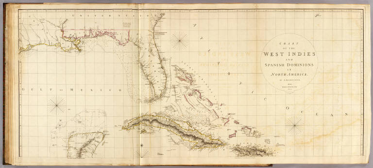
Arrowsmith, Aaron
Full Title
Chart of the West Indies and Spanish Dominions in North America. (Sheet 1). By A. Arrowsmith. 1803. Hydrographer to H.R.H. the Prince of Wales. Additions to 1810. London, Published June 1st, 1803 by A. Arrowsmith, 10 Soho Square. Jones, Smith & Co. sc., Beaufort Buildgs., Strand.
List No
5699.015
Note
Engraved map. Outline hand col. Relief shown by hachures; depths by soundings. Sheet 1 of 2. Shows settlements, roads, rivers, etc. Includes descriptive notes. Printed on 2 sheets, joined together.
Author
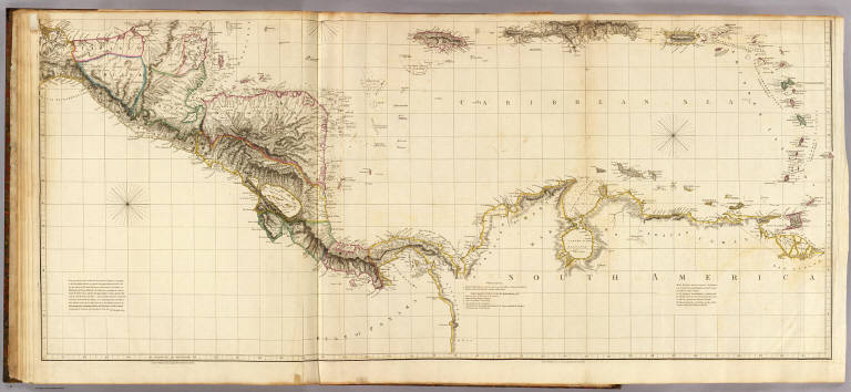
Arrowsmith, Aaron
Full Title
(Chart of the West Indies and Spanish Dominions in North America. Sheet 2. By A. Arrowsmith. 1803. Hydrographer to H.R.H. the Prince of Wales. Additions to 1810). London, Published June 1st, 1803 by A. Arrowsmith, 10 Soho Square. (Jones, Smith & Co. sc., Beaufort Buildgs., Strand)
List No
5699.016
Note
Engraved map. Outline hand col. Relief shown by hachures; depths by soundings. Sheet 2 of 2. Shows settlements, roads, rivers, etc. Includes descriptive notes. Printed on 2 sheets, joined together.
Author
Arrowsmith, Aaron
Full Title
(Composite of) Chart of the West Indies and Spanish Dominions in North America. By A. Arrowsmith. 1803. Hydrographer to H.R.H. the Prince of Wales. Additions to 1810. London, Published June 1st, 1803 by A. Arrowsmith, 10 Soho Square. Jones, Smith & Co. sc., Beaufort Buildgs., Strand.
List No
5699.017
Note
Engraved map. Outline hand col. Relief shown by hachures; depths by soundings. Shows settlements, roads, rivers, etc. Includes descriptive notes. Printed on 4 sheets, mounted as 2.
Author
Arrowsmith, Aaron
Full Title
Outlines of the physical and political divisions of South America: (Sheet 1) delineated by A. Arrowsmith, partly from scarce and original documents, published before the year 1806 but principally from manuscript maps & surveys made between the years 1771 and 1806, corrected from accurate astronomical observations to 1810. London, Published 4th January 1811 by A. Arrowsmith, No. 10 Soho Square, Hydrographer to H.R. H. the Prince of Wales. Additions to 1814, 1817. Engraved by Edwd. Jones.
List No
5699.018
Note
Engraved map. Outline hand col. Relief shown by hachures. Sheet 1 of 6. Shows settlements, roads, rivers, Indian tribes, etc.
Author
Arrowsmith, Aaron
Full Title
(Outlines of the physical and political divisions of South America: Sheet 2. Delineated by A. Arrowsmith, partly from scarce and original documents, published before the year 1806 but principally from manuscript maps & surveys made between the years 1771 and 1806, corrected from accurate astronomical observations to 1810) London, Published 4th January 1811 by A. Arrowsmith, No. 10 Soho Square, (Hydrographer to H.R. H. the Prince of Wales. Additions to 1814, 1817. Engraved by Edwd. Jones)
List No
5699.019
Note
Engraved map. Outline hand col. Relief shown by hachures. Sheet 2 of 6. Shows settlements, roads, rivers, Indian tribes, etc.
Author
Arrowsmith, Aaron
Full Title
(Outlines of the physical and political divisions of South America: Sheet 3. Delineated by A. Arrowsmith, partly from scarce and original documents, published before the year 1806 but principally from manuscript maps & surveys made between the years 1771 and 1806, corrected from accurate astronomical observations to 1810) London, Published 4th January 1811 by A. Arrowsmith, No. 10 Soho Square, (Hydrographer to H.R. H. the Prince of Wales. Additions to 1814, 1817. Engraved by Edwd. Jones)
List No
5699.020
Note
Engraved map. Outline hand col. Relief shown by hachures. Sheet 3 of 6. Shows settlements, roads, rivers, Indian tribes, etc.
Author
Arrowsmith, Aaron
Full Title
(Outlines of the physical and political divisions of South America: Sheet 4. Delineated by A. Arrowsmith, partly from scarce and original documents, published before the year 1806 but principally from manuscript maps & surveys made between the years 1771 and 1806, corrected from accurate astronomical observations to 1810) London, Published 4th January 1811 by A. Arrowsmith, No. 10 Soho Square, (Hydrographer to H.R. H. the Prince of Wales. Additions to 1814, 1817. Engraved by Edwd. Jones)
List No
5699.021
Note
Engraved map. Outline hand col. Relief shown by hachures. Sheet 4 of 6. Shows settlements, roads, rivers, Indian tribes, etc.
Author
Arrowsmith, Aaron
Full Title
(Outlines of the physical and political divisions of South America: Sheet 5. Delineated by A. Arrowsmith, partly from scarce and original documents, published before the year 1806 but principally from manuscript maps & surveys made between the years 1771 and 1806, corrected from accurate astronomical observations to 1810) (with Inset map of the Orinoco and Meta rivers). London, Published 4th January 1811 by A. Arrowsmith, No. 10 Soho Square, (Hydrographer to H.R. H. the Prince of Wales. Additions to 1814, 1817. Engraved by Edwd. Jones)
List No
5699.022
Note
Engraved map. Outline hand col. Relief shown by hachures. Sheet 5 of 6. Shows settlements, roads, rivers, Indian tribes, etc. Scale of inset (ca. 1:118,000)
Author
Arrowsmith, Aaron
Full Title
(Outlines of the physical and political divisions of South America: Sheet 6. Delineated by A. Arrowsmith, partly from scarce and original documents, published before the year 1806 but principally from manuscript maps & surveys made between the years 1771 and 1806, corrected from accurate astronomical observations to 1810). London, Published 4th January 1811 by A. Arrowsmith, No. 10 Soho Square, (Hydrographer to H.R. H. the Prince of Wales. Additions to 1814, 1817. Engraved by Edwd. Jones)
List No
5699.023
Note
Engraved map. Outline hand col. Relief shown by hachures. Sheet 6 of 6. Shows settlements, roads, rivers, Indian tribes, etc. Patagonia, Tierra del Fuego and the Falkland Islands are in inset map.
Author
Arrowsmith, Aaron
Full Title
(Composite of) Outlines of the physical and political divisions of South America: delineated by A. Arrowsmith, partly from scarce and original documents, published before the year 1806 but principally from manuscript maps & surveys made between the years 1771 and 1806, corrected from accurate astronomical observations to 1810. (with Inset map of the Orinoco and Meta rivers). London, Published 4th January 1811 by A. Arrowsmith, No. 10 Soho Square, Hydrographer to H.R. H. the Prince of Wales. Additions to 1814, 1817. Engraved by Edwd. Jones.
List No
5699.024
Note
Engraved map. Outline hand col. Relief shown by hachures. Shows settlements, roads, rivers, Indian tribes, etc.
Author
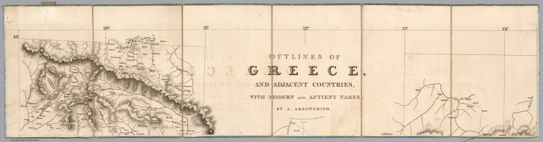
Arrowsmith, Aaron
Full Title
Covers to) Outlines of Greece, And Adjacent Countries, With Modern and Antient Names, By A. Arrowsmith. London, Published 2nd March, 1819, by A. Arrowsmith, 10 Soho Square, Hydrographer to His Majesty.
List No
6707.001
Note
A very detailed map of ancient and modern Greece with many inset maps of towns, regions, and islands.
Author
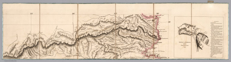
Arrowsmith, Aaron
Full Title
(Sheet 1) Outlines of Greece, And Adjacent Countries, With Modern and Antient Names, By A. Arrowsmith. London, Published 2nd March, 1819, by A. Arrowsmith, 10 Soho Square, Hydrographer to His Majesty.
List No
6707.002
Note
A very detailed map of ancient and modern Greece with many inset maps of towns, regions, and islands.
Author
Arrowsmith, Aaron
Full Title
(Sheet 2) Outlines of Greece, And Adjacent Countries, With Modern and Antient Names, By A. Arrowsmith. London, Published 2nd March, 1819, by A. Arrowsmith, 10 Soho Square, Hydrographer to His Majesty.
List No
6707.003
Note
A very detailed map of ancient and modern Greece with many inset maps of towns, regions, and islands.
Author
Arrowsmith, Aaron
Full Title
(Sheet 3) Outlines of Greece, And Adjacent Countries, With Modern and Antient Names, By A. Arrowsmith. London, Published 2nd March, 1819, by A. Arrowsmith, 10 Soho Square, Hydrographer to His Majesty.
List No
6707.004
Note
A very detailed map of ancient and modern Greece with many inset maps of towns, regions, and islands.
Author
Arrowsmith, Aaron
Full Title
(Sheet 4) Outlines of Greece, And Adjacent Countries, With Modern and Antient Names, By A. Arrowsmith. London, Published 2nd March, 1819, by A. Arrowsmith, 10 Soho Square, Hydrographer to His Majesty.
List No
6707.005
Note
A very detailed map of ancient and modern Greece with many inset maps of towns, regions, and islands.
Author
Arrowsmith, Aaron
Full Title
(Sheet 5) Outlines of Greece, And Adjacent Countries, With Modern and Antient Names, By A. Arrowsmith. London, Published 2nd March, 1819, by A. Arrowsmith, 10 Soho Square, Hydrographer to His Majesty.
List No
6707.006
Note
A very detailed map of ancient and modern Greece with many inset maps of towns, regions, and islands.
Author
Arrowsmith, Aaron
Full Title
(Sheet 6) Outlines of Greece, And Adjacent Countries, With Modern and Antient Names, By A. Arrowsmith. London, Published 2nd March, 1819, by A. Arrowsmith, 10 Soho Square, Hydrographer to His Majesty.
List No
6707.007
Note
A very detailed map of ancient and modern Greece with many inset maps of towns, regions, and islands.
Author
Arrowsmith, Aaron
Full Title
(Composite Map of) Outlines of Greece, And Adjacent Countries, With Modern and Antient Names, By A. Arrowsmith. London, Published 2nd March, 1819, by A. Arrowsmith, 10 Soho Square, Hydrographer to His Majesty.
List No
6707.008
Note
A very detailed map of ancient and modern Greece with many inset maps of towns, regions, and islands.
1-35 of 35
|