|
REFINE
Browse All : Images by Anville, Jean Baptiste Bourguignon d, 1697-1782 from 1804 and 1799
1-8 of 8
Author
[Anville, Jean Baptiste Bourguignon d, 1697-1782, Dunn, Samuel, Robert Laurie & James Whittle]
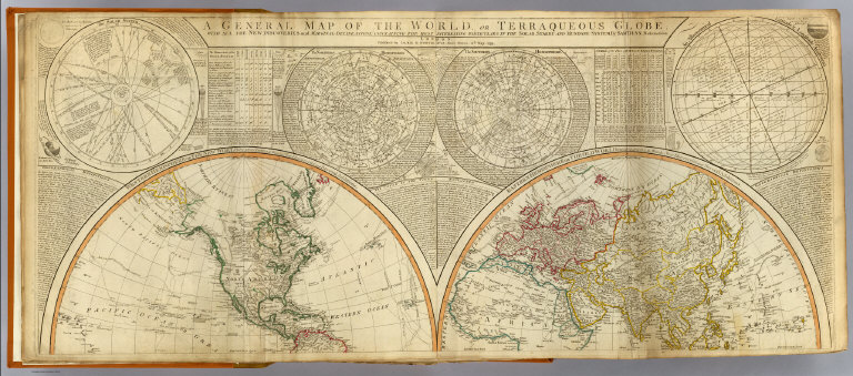
Full Title
A general map of the World or terraqueous globe with all the new discoveries and marginal delineations, containing the most interesting particulars of the solar, starry and mundane system, by Saml. Dunn, mathematician. (North half). London, Published by Laurie & Whittle, No. 53, Fleet Street, 12th May, 1799.
List No
2310.002
Note
Hand colored engraved map. Relief shown pictorially. Contents: Western Hemisphere or the New World by Mr. d'Anville, with new discoveries and several additions -- Eastern Hemisphere or the Old World by Mr. d'Anville, with the new discoveries and several additions. Ancillary maps or charts: The Solar System -- The Northern Hemisphere -- The Southern Hemisphere -- An astronomical latitude & longitude analemma. Printed on 2 sheets; joined.
Author
[Anville, Jean Baptiste Bourguignon d, 1697-1782, Dunn, Samuel, Riccioli, Giovanni Battista, Robert Laurie & James Whittle]
Full Title
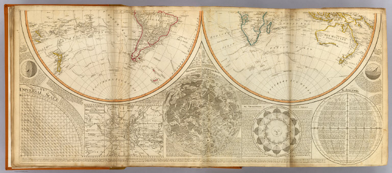
(A general map of the World or terraqueous globe with all the new discoveries and marginal delineations, containing the most interesting particulars of the solar, starry and mundane system, by Saml. Dunn, mathematician. South half. London, Published by Laurie & Whittle, No. 53, Fleet Street, 12th May, 1799)
List No
2310.003
Note
Hand colored engraved map. Relief shown pictorially. Contents: Western Hemisphere or the New World by Mr. d'Anville, with new discoveries and several additions -- Eastern Hemisphere or the Old World by Mr. d'Anville, with the new discoveries and several additions. Ancillary maps or charts: An universal scale -- A chart of the World according to Mercator's projection, with the rhumb lines -- Selenography or A map of the Moon according to Father Riccioli -- The vicissitude of seasons explained -- The analemma. Printed on 2 sheets; joined.
Author
[Anville, Jean Baptiste Bourguignon d, 1697-1782, Dunn, Samuel, Riccioli, Giovanni Battista, Robert Laurie & James Whittle]
Full Title
(Composite of) A general map of the World or terraqueous globe with all the new discoveries and marginal delineations, containing the most interesting particulars of the solar, starry and mundane system, by Saml. Dunn, mathematician. London, Published by Laurie & Whittle, No. 53, Fleet Street, 12th May, 1799.
List No
2310.004
Note
Digital composite of north and south halves of hand colored engraved map. Relief shown pictorially. Contents: Western Hemisphere or the New World by Mr. d'Anville, with new discoveries and several additions -- Eastern Hemisphere or the Old World by Mr. d'Anville, with the new discoveries and several additions. Ancillary maps or charts: The Solar System -- The Northern Hemisphere -- The Southern Hemisphere -- An astronomical latitude & longitude analemma -- An universal scale -- A chart of the World according to Mercator's projection, with the rhumb lines -- Selenography or A map of the Moon according to Father Riccioli -- The vicissitude of seasons explained -- The analemma. Printed on 4 sheets; joined as 2.
Author
[Anville, Jean Baptiste Bourguignon d, 1697-1782, Robert Laurie & James Whittle]
Full Title
A new map of the middle and upper parts of Italy, wherein are included the State of the Church, the Grand Duchy of Tuscany; Austrian Lombardy; the states of Parma and Modena, and the republics of Venice, Genoa, Lucca &ca. with the island of Corsica. Drawn with many improvements and additions, from the general map of D'Anville &c. &c. Published 25th March 1799 by Robt. Laurie & Jas. Whittle, No. 53 Fleet Street, London. Jones & Smith sculp., 13 Pleasant Row, Pentonville.
List No
2310.032
Note
Hand colored engraved map. Relief shown pictorially.
Author
[Anville, Jean Baptiste Bourguignon d, 1697-1782, Robert Laurie & James Whittle]
Full Title
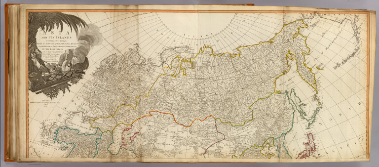
Asia and its islands according to d'Anville; divided into empires, kingdoms, states, regions, &c. &c. with the European possessions and settlements in the East Indies and an exact delineation of all the discoveries made in the eastern parts by the English under Captn. Cook, Vancouver & Peyrouse. (North sheets). London, Publish'd by Laurie & Whittle, No. 53, Fleet Street, Feby. 2d, 1799.
List No
2310.052
Note
Hand colored engraved map. Relief shown pictorially. Includes illustrated cartouche. Printed on 2 sheets; joined.
Full Title
(Asia and its islands according to d'Anville; divided into empires, kingdoms, states, regions, &c. &c. with the European possessions and settlements in the East Indies and an exact delineation of all the discoveries made in the eastern parts by the English under Captn. Cook, Vancouver & Peyrouse. Middle sheets. London, Publish'd by Laurie & Whittle, No. 53, Fleet Street, Feby. 2d, 1799)
List No
2310.053
Note
Hand colored engraved map. Relief shown pictorially. Printed on 2 sheets; joined.
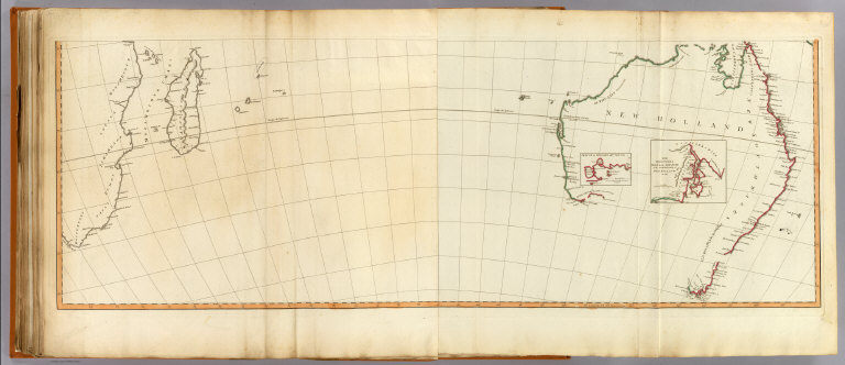
Full Title
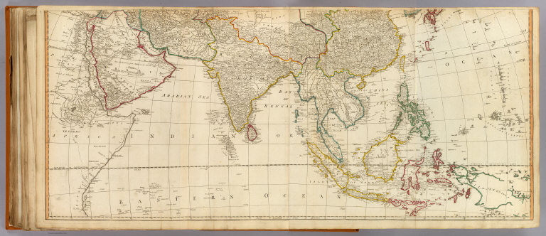
(Asia and its islands according to d'Anville; divided into empires, kingdoms, states, regions, &c. &c. with the European possessions and settlements in the East Indies and an exact delineation of all the discoveries made in the eastern parts by the English under Captn. Cook, Vancouver & Peyrouse. South sheets. London, Publish'd by Laurie & Whittle, No. 53, Fleet Street, Feby. 2d, 1799)
List No
2310.054
Note
Digital composite of hand colored engraved map. Relief shown pictorially. Inset maps: Sketch of King Geo. IIIds Sound -- The discoveries made by the ship Duke on the south extremity of New Holland in 1791. Printed on 2 sheets; joined.
Author
[Anville, Jean Baptiste Bourguignon d, 1697-1782, Robert Laurie & James Whittle]
Full Title
(Composite of) Asia and its islands according to d'Anville; divided into empires, kingdoms, states, regions, &c. &c. with the European possessions and settlements in the East Indies and an exact delineation of all the discoveries made in the eastern parts by the English under Captn. Cook, Vancouver & Peyrouse. London, Publish'd by Laurie & Whittle, No. 53, Fleet Street, Feby. 2d, 1799.
List No
2310.055
Note
Digital composite of hand colored engraved map. Relief shown pictorially. Inset maps: Sketch of King Geo. IIIds Sound -- The discoveries made by the ship Duke on the south extremity of New Holland in 1791. Includes illustrated cartouche. Printed on 6 sheets; joined as 3.
1-8 of 8
|