|
REFINE
Browse All : Atlas Map and World Atlas by Anville, Jean Baptiste Bourguignon d, 1697-1782Author
Brue, Adrien Hubert, 1786-1832
Full Title
La Palestine, par le Sr D'Anville. MDCCLXVII (1767). (to accompany) Atlas physique et politique des cinq parties du monde, par H. Brue.
List No
13565.006
Note
Unnumbered, supplementary plate. Engraved outline color map, with insets: Les Tribus. Jerusalem. Positions determinees par des Distances donnees.
Author
Brue, Adrien Hubert, 1786-1832
Full Title
Orbis Veteribus Notus Auspiciis Serenissimi Principis Ludovici Philippi Aurelianorum Ducis . . . Auctor D'Anville. MDCCLXIII (1763). H. Gravelot. (to accompany) Atlas physique et politique des cinq parties du monde, par H. Brue.
List No
13565.007
Note
Outline hand color engraved map of the Ancient World. Title and place names in Latin. Relief shown pictorially. Includes decorative title cartouche, diagram of wind directions and text.
Author
Brue, Adrien Hubert, 1786-1832
Full Title
Aegyptus antiqua : mandato serenissimi Delphini publici juris facta : Auctor D'Anville ... MDCCLXV (1765). (to accompany) Atlas physique et politique des cinq parties du monde, par H. Brue.
List No
13565.008
Note
Outline hand color engraved map. Title and place names in Latin. Includes index.
Author
Brue, Adrien Hubert, 1786-1832
Full Title
Graeciae antiquae, specimen geographicum. Auctor D'Anville ... M DCCLXI (1762). Guill. De-la-Haye. (to accompany) Atlas physique et politique des cinq parties du monde, par H. Brue.
List No
13565.009
Note
Outline hand color engraved map. Inset: Graeciae (laxe sumptae) Partes Boreales ... Title and place names in Latin.
Author
Brue, Adrien Hubert, 1786-1832
Full Title
Tabula Italiae Antiquae Geographica : Quam Excellentissimus Dominus Dux De La Rochefoucauld in aere incidi curavit. Auctor D'Anville ... M DCCLXIV (1764). (to accompany) Atlas physique et politique des cinq parties du monde, par H. Brue.
List No
13565.011
Note
Outline hand color engraved map. Insets: Urbs Septicollis. Roma. Title and place names in Latin.
Author
Brue, Adrien Hubert, 1786-1832
Full Title
Orbis Romani Pars Occidentalis : Auspiciis Serenissimi Principis Ludovici Philippi Aurelianorum Ducis publici juris facta. Auctor D'Anville ... M DCCLXIII (1763). G. De-la-Haye. (to accompany) Atlas physique et politique des cinq parties du monde, par H. Brue.
List No
13565.012
Note
Outline hand color engraved map. Western part.
Author
Brue, Adrien Hubert, 1786-1832
Full Title
Orbis Romani Pars Orientalis : Auspiciis Serenissimi Principis Ludovici Philippi Aurelianorum Ducis publici juris facta. Auctor D'Anville ... M DCCLXIV (1764). G. De-la-Haye. (to accompany) Atlas physique et politique des cinq parties du monde, par H. Brue.
List No
13565.013
Note
Outline hand color engraved map. Eastern part.
Author
[Wyld, James, 1812-1887, Wyld, James, 1790-1836]
Full Title
Orbis veteribus notus. Auctore D' Anville. Published by Jas. Wyld. 1838. (to accompany) A new general atlas of modern geography : consisting of a complete collection of maps of the four quarters of the globe ... London: Published by James Wyld, Charing Cross East, Geographer to the King.
List No
13170.004
Note
Double page outline hand color engraved map of the Ancient World, published by James Wyld. Covers all of Europe, Asia Minor, Arabia and India, much of Northern Africa, and parts of Southeast Asia. Title and place names in Latin. Relief shown pictorially. Includes a diagram of wind directions, decorative title cartouche and text.
Author
[Andriveau-Goujon, J., Anville, Jean Baptiste Bourguignon d, 1697-1782]
Full Title
Orbis Veteribus Notus Auspiciis Serenissimi Principis Ludovici Philippi Aurelianorum Ducis . . . Auctor D'Anville. MDCCLXIII. Guill. De-la-Haye. (to accompany) Atlas de choix ou Recueil de cartes de geographie ancienne et moderne.
List No
11124.005
Note
Double page outline hand color engraved map of the Ancient World, as known to the ancient civilizations of Europe, published by J.B.B. D'Anville in Paris. Covers all of Europe, Asia Minor, Arabia and India, much of Northern Africa, and parts of Southeast Asia. Title and place names in Latin. Relief shown pictorially. Includes a diagram of wind directions and text.
Author
[Andriveau-Goujon, J., Anville, Jean Baptiste Bourguignon d, 1697-1782]
Full Title
Graeciae antiquae, specimen geographicum. Auctor D'Anville. Regiae Humaniorium Litterarum Academiae, et Scientiarum Petropolitanae Socius, M DCCLXII. Apud Auctorem, in AEdibus Regiis, vulgo les Galeries du Louvre. (Engraved by) Guill. De-la-Haye. (inset) Graeciae Partes Borealis. (to accompany) Atlas de choix ou Recueil de cartes de geographie ancienne et moderne.
List No
11124.006
Note
Double page outline hand color engraved map of the Ancient Greece. Title and place names in Latin. Relief shown pictorially.
Author
[Andriveau-Goujon, J., Anville, Jean Baptiste Bourguignon d, 1697-1782]
Full Title
Tabula Italiae antique geographica, Quam exellentissssinus dominus Dux de la Rochefoucauld in aere incidi curavit. Auctor D'Anville ... MDCCLXIV. (inset: Roma). (with) Urbs Septicollis. (to accompany) Atlas de choix ou Recueil de cartes de geographie ancienne et moderne.
List No
11124.008
Note
Double page outline hand color engraved map of Italy, Corsica, Sardinia and surrounding areas. Show towns, mountains, rivers, lakes, bays, islands, gulfs, etc. inset map of the area around Rome and a second map showing the ancient areas of the 7 hills of Rome. Relief shown pictorially.
Author
[Andriveau-Goujon, J., Anville, Jean Baptiste Bourguignon d, 1697-1782]
Full Title
Orbis Romani, pars occidentalis. Auspiciis Serenissimi Principis Ludovici Philippi, Aurelianorum Ducis publici juris facta. Auctor d'Anville, Regiae Humaniorium Litterarum Academiae, et Scientiarum Petropolitanae Socius, Celsitudinique Serenissimae a Secretis. MDCCLXIII. (Engraved by) G: De-la-Haye. (to accompany) Atlas de choix ou Recueil de cartes de geographie ancienne et moderne.
List No
11124.009
Note
Double page outline hand color engraved map of the Western part of the Roman Empire. extends from Italy, Siciily and Spain in the south to the British Isles in the north, centered on the Mediterranean. Show towns, mountains, rivers, lakes, bays, islands, gulfs, etc. Relief shown pictorially.
Author
[Andriveau-Goujon, J., Anville, Jean Baptiste Bourguignon d, 1697-1782]
Full Title
Orbis Romani, pars orientalis. Auspiciis Serenissimi Principis Ludovici Philippi, Aurelianorum Ducis publici juris facta. Auctor d'Anville, Regiae Humaniorium Litterarum Academiae, et Scientiarum Petropolitanae Socius, Celsitudinique Serenissimae a Secretis. MDCCLXIV. (Engraved by) Guill: De-la-Haye. (to accompany) Atlas de choix ou Recueil de cartes de geographie ancienne et moderne.
List No
11124.010
Note
Double page outline hand color engraved map of the Eastern part of the Roman Empire. extends from Greece and the Balkans in the west to Iran, and is centered on Cyprus and Asia Minor. Show towns, mountains, rivers, lakes, bays, islands, gulfs, etc. Relief shown pictorially.
Author
Brue, Adrien Hubert, 1786-1832
Full Title
Asiae que vulgo Minor dicitur et Syrie ... Auctor D'Anville ... M DCCLXIV (1764). Guill. De-la-Haye. (to accompany) Atlas physique et politique des cinq parties du monde, par H. Brue.
List No
13565.046
Note
Outline hand color engraved map. Insets: Bosporus. Dardanellen. Title and place names in Latin.
Author
[Faden, William, 1749-1836, Anville, Jean Baptiste Bourguignon d, 1697-1782, Seale, Richard William, Wilkinson, Robert, -approximately 1825, Sayer, Robert, 1725-1794]
Full Title
Italy; with the islands of Sicily, Sardinia and Corsica. By Mr. d'Anville, Geographer to the French King. Engrav'd from the original, publish'd at Paris at ye expence of the Duke of Orleans, First Prince of the Blood. By R. W. Seale. London. Printed for Robt. Wilkinson, No. 58, in Cornhill, Robt. Sayer, No. 53, in Fleet Street, and Carington Bowles, No. 69, in St. Paul's Church Yard.
List No
14383.029
Note
Map of Italy, with the islands of Sicily, Sardinia and Corsica, as of 1794. Shows political boundaries, cities, roads, topography, bodies of water, drainage, coastlines and islands. Relief shown pictorially. Includes latitudinal and longitudinal lines, as well as a legend and twelve bar scales. Decorative cartouche. Hand-colored engraving. Map is 83 x 67 cm, on fold-out sheet 88 x 72 cm.
Author
[Faden, William, 1749-1836, Anville, Jean Baptiste Bourguignon d, 1697-1782, Boulton, S.]
Full Title
Africa, with all its states, kingdoms, republics, regions, islands, &ca. Improved and inlarged from d'Anville''s Map; to which have been added a particular chart of the Gold Coast, wherein are distinguished all the European forts and factories, by S. Boulton, and also a summary description relative to the trade and natural produce, manners and customs of the African continent and islands. London, published by Laurie & Whittle, No. 53 Fleet-Street, as the Act directs, 12th May, 1794. (1)
List No
14383.048
Note
Map of Africa, showing northern half of the continent, as of 1794. Shows political boundaries, cities, roads, topography, bodies of water, drainage, coastlines and islands. Relief shown pictorially. Includes latitudinal and longitudinal lines, as well as seven bar scales and arrows indicating the direction of ocean currents. With inset map: Azores. Decorative cartouche. Descriptive text throughout, including notes on exploration and other history. Hand-colored engraving. Map is 52 x 122 cm, on fold-out sheet 55 x 131 cm. With stamp: Liverpool Library. First of two sheets; second sheet shows southern half of the African continent.
Author
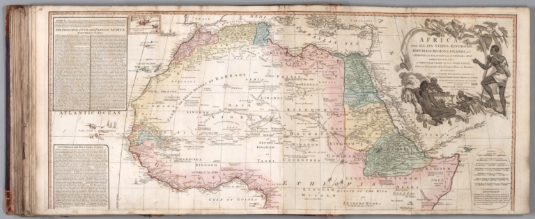
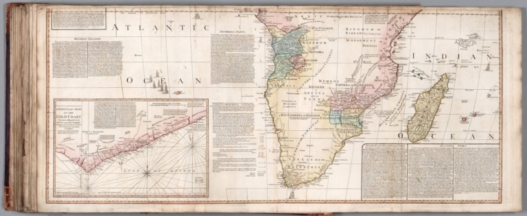
[Faden, William, 1749-1836, Anville, Jean Baptiste Bourguignon d, 1697-1782, Boulton, S.]
Full Title
Africa, with all its states, kingdoms, republics, regions, islands, &ca. Improved and inlarged from d'Anville''s Map; to which have been added a particular chart of the Gold Coast, wherein are distinguished all the European forts and factories, by S. Boulton, and also a summary description relative to the trade and natural produce, manners and customs of the African continent and islands. London, published by Laurie & Whittle, No. 53 Fleet-Street, as the Act directs, 12th May, 1794. (2)
List No
14383.049
Note
Map of Africa, showing southern half of the continent, as of 1794. Shows political boundaries, cities, roads, topography, bodies of water, drainage, coastlines and islands. Relief shown pictorially. Includes latitudinal and longitudinal lines, as well as seven bar scales and arrows indicating the direction of ocean currents. With inset map: A particular chart of the Gold Coast. (Decorative cartouche on first sheet). Descriptive text throughout, including notes on exploration and other history. Hand-colored engraving. Map is 52 x 122 cm, on fold-out sheet 55 x 131 cm. With stamp: Liverpool Library. Second of two sheets; first sheet shows northern half of the African continent.
Author
[Faden, William, 1749-1836, Anville, Jean Baptiste Bourguignon d, 1697-1782]
Full Title
Egypt, called in the country Missir. By Mons. R. d'Anville of the Royal Academy of Belles Lettres, & of that of Siçiences of Petersburg, Secretary to H. S. H. the Duke of Orleans, MDCCLXV. Published 12th. May, 1794 by Laurie & Whittle, No 53 Fleet Street, London.
List No
14383.052
Note
Map of Egypt, as of 1765. Shows political boundaries, cities, roads, topography, deserts, bodies of water, drainage, coastlines and islands. Relief shown pictorially. Includes latitudinal and longitudinal lines, as well as nine bar scales. Descriptive text throughout. Hand-colored engraving. Map is 66 x 40 cm, on double sheet 75 x 55 cm. With stamp: Liverpool Library.
Author
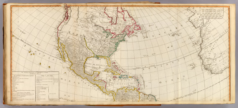
[Faden, William, 1749-1836, Anville, Jean Baptiste Bourguignon d, 1697-1782, Pownall, Thomas, 1722-1805]
Full Title
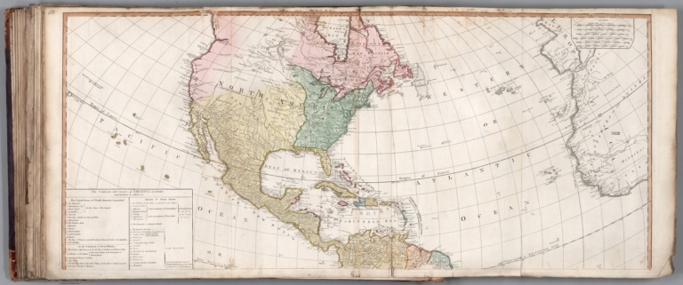
A new map of the whole continent of America, divided into North and South and West Indies, wherein are exactly described the United States of North America as well as the several European possessions according to the preliminaries of Peace signed at Versailles Jan. 20, 1783. Compiled from Mr. d'Anville's maps of that continent, with the addition of the Spanish discoveries in 1775 to the north of California & corrected in the several parts belonging to Great Britain, from the original materials of Governor Pownall, M. P. London, publish'd by Laurie & Whittle, No. 53, Fleet Street, as the Act directs, 12th. May, 1794. (1)
List No
14383.053
Note
Map of North America and the West Indies, as of 1794. Shows political boundaries, cities, roads, topography, bodies of water, drainage, coastlines, islands and sand banks. Relief shown with hachures. Includes latitudinal and longitudinal lines, as well as six bar scales. Indexed to indicate place names. (Decorative cartouche on second sheet). Descriptive text throughout, including notes on exploration. Hand-colored engraving. Map is 51 x 118 cm, on fold-out sheet 55 x 126 cm. With stamp: Liverpool Library. First of two sheets; second sheet shows South America.
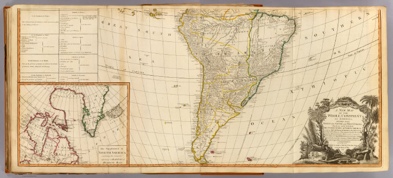
Author
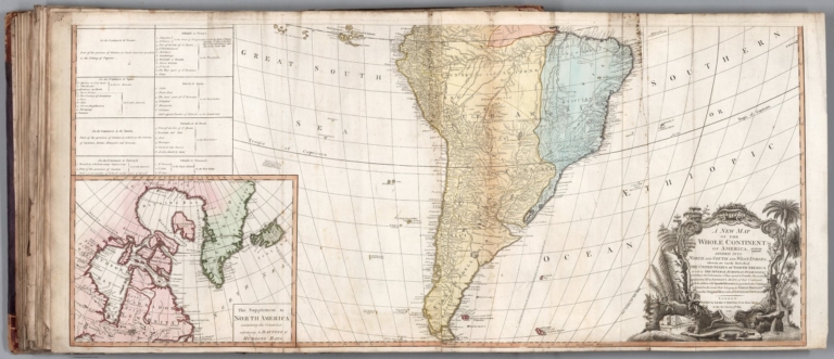
[Faden, William, 1749-1836, Anville, Jean Baptiste Bourguignon d, 1697-1782, Pownall, Thomas, 1722-1805]
Full Title
A new map of the whole continent of America, divided into North and South and West Indies, wherein are exactly described the United States of North America as well as the several European possessions according to the preliminaries of Peace signed at Versailles Jan. 20, 1783. Compiled from Mr. d'Anville's maps of that continent, with the addition of the Spanish discoveries in 1775 to the north of California & corrected in the several parts belonging to Great Britain, from the original materials of Governor Pownall, M. P. London, publish'd by Laurie & Whittle, No. 53, Fleet Street, as the Act directs, 12th. May, 1794. (2)
List No
14383.054
Note
Map of South America, as of 1794. Shows political boundaries, cities, roads, topography, bodies of water, drainage, coastlines, islands and sand banks. Relief shown with hachures. Includes latitudinal and longitudinal lines, as well as six bar scales. Indexed to indicate place names. Decorative cartouche. Descriptive text throughout, including notes on exploration. With inset map: The supplement to North America containing the countries adjoining to Baffins & Hudsons Bays. Hand-colored engraving. Map is 51 x 118 cm, on fold-out sheet 55 x 126 cm. With stamp: Liverpool Library. Second of two sheets; first sheet shows North America and the West Indies.
Author
Anville, Jean Baptiste Bourguignon d, 1697-1782
Full Title
A new map of Turkey in Asia by Monsr. d'Anville, first geographer to the most Christian King with several additions. London, published by Laurie & Whittle, no. 53 Fleet Street as the Act directs, 12th May, 1794.
List No
2104.043
Note
Engraved map. Full hand col. Relief shown pictorially. "41" on verso.
Author
[Anville, Jean Baptiste Bourguignon d, 1697-1782, Faden, William, 1750?-1836]
Full Title
A map of America or the New World, wherein are introduced all the known parts of the Western Hemisphere, from the map of D'Anville; with the necessary alterations, and the addition of the discoveries made since the year 1761. London: published by W. Faden, Geographer to the King and to H.R.H. the Prince of Wales, Charing-Cross, April 12th, 1797. Wm. Palmer sculp.
List No
2104.052
Note
Engraved map. Hand col. Relief shown pictorially. Shows settlements, Indian tribes, 1493 line of demarcation between Spanish and Portuguese possessions, etc. Prime meridian: Ferro. "49" on verso.
Author
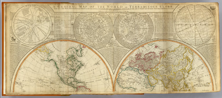
[Anville, Jean Baptiste Bourguignon d, 1697-1782, Dunn, Samuel, Robert Laurie & James Whittle]
Full Title
A general map of the World or terraqueous globe with all the new discoveries and marginal delineations, containing the most interesting particulars of the solar, starry and mundane system, by Saml. Dunn, mathematician. (North half). London, Published by Laurie & Whittle, No. 53, Fleet Street, 12th May, 1799.
List No
2310.002
Note
Hand colored engraved map. Relief shown pictorially. Contents: Western Hemisphere or the New World by Mr. d'Anville, with new discoveries and several additions -- Eastern Hemisphere or the Old World by Mr. d'Anville, with the new discoveries and several additions. Ancillary maps or charts: The Solar System -- The Northern Hemisphere -- The Southern Hemisphere -- An astronomical latitude & longitude analemma. Printed on 2 sheets; joined.
Author
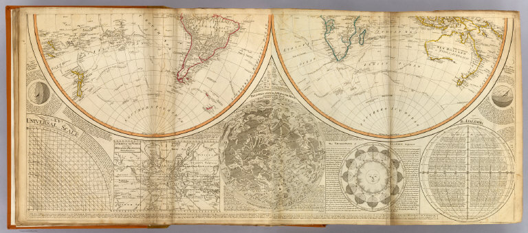
[Anville, Jean Baptiste Bourguignon d, 1697-1782, Dunn, Samuel, Riccioli, Giovanni Battista, Robert Laurie & James Whittle]
Full Title
(A general map of the World or terraqueous globe with all the new discoveries and marginal delineations, containing the most interesting particulars of the solar, starry and mundane system, by Saml. Dunn, mathematician. South half. London, Published by Laurie & Whittle, No. 53, Fleet Street, 12th May, 1799)
List No
2310.003
Note
Hand colored engraved map. Relief shown pictorially. Contents: Western Hemisphere or the New World by Mr. d'Anville, with new discoveries and several additions -- Eastern Hemisphere or the Old World by Mr. d'Anville, with the new discoveries and several additions. Ancillary maps or charts: An universal scale -- A chart of the World according to Mercator's projection, with the rhumb lines -- Selenography or A map of the Moon according to Father Riccioli -- The vicissitude of seasons explained -- The analemma. Printed on 2 sheets; joined.
Author
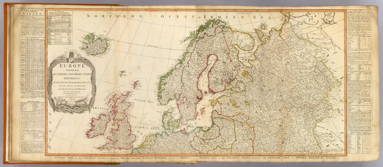
[Anville, Jean Baptiste Bourguignon d, 1697-1782, Kitchin, Thomas, Robert Laurie & James Whittle]
Full Title
Europe divided into its empires, kingdoms, states, republics, &c. (North half). By Thos. Kitchin, Hydrographer to the King, with many additions and improvements from the latest surveys and observations of Mr. d'Anville. London, Published by Laurie & Whittle, No. 53, Fleet Street, 12th May, 1795.
List No
2310.005
Note
Hand colored engraved map. Relief shown pictorially. Includes statistical tables in side margins. Contents: Western part of the northern states including the British Islands, Norway, Denmark and part of Sweden -- Eastern part of the northern states including the eastern part of Sweden; European Russia &c. Printed on 2 sheets; joined. Prime meridians: London and Ferro.
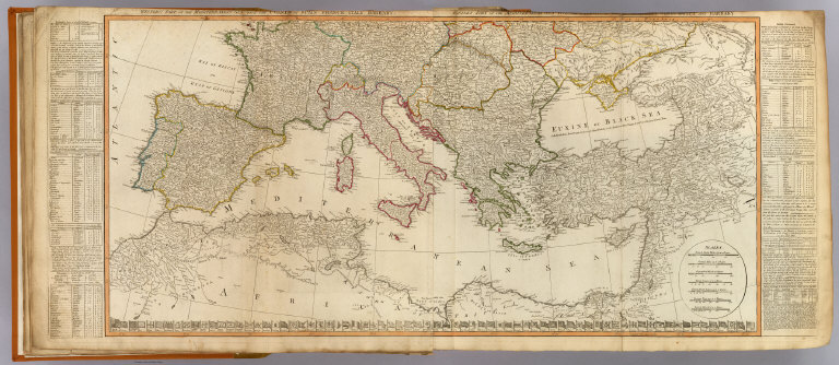
Full Title
(Europe divided into its empires, kingdoms, states, republics, &c. (South half). By Thos. Kitchin, Hydrographer to the King, with many additions and improvements from the latest surveys and observations of Mr. d'Anville. London, Published by Laurie & Whittle, No. 53, Fleet Street, 12th May, 1795)
List No
2310.006
Note
Hand colored engraved map. Relief shown pictorially. Includes statistical tables in side margins and national flags at bottom of map. Contents: Western part of the Mediterranean Sea with the coasts of Spain, France, Italy, Barbary -- Eastern part of the Mediterranean Sea with the coasts of Turky, Anatolia and Barbary. Printed on 2 sheets; joined. Prime meridians: London and Ferro.
Author
[Anville, Jean Baptiste Bourguignon d, 1697-1782, Robert Laurie & James Whittle]
Full Title
A new map of Italy, with the islands of Sicily, Sardinia & Corsica. From Monsr. D'Anville: to which have been added the post roads and several other improvements. London, Published by Laurie & Whittle, No. 53 Fleet Street, as the act directs 12th May, 1794. (Title in upper margin:) Carte de l'Italie, et de toutes ses routes de poste, a l'usage des voyageurs.
List No
2310.030
Note
Hand colored engraved map. Relief shown pictorially.
Author
[Anville, Jean Baptiste Bourguignon d, 1697-1782, Robert Laurie & James Whittle]
Full Title
A new map of the middle and upper parts of Italy, wherein are included the State of the Church, the Grand Duchy of Tuscany; Austrian Lombardy; the states of Parma and Modena, and the republics of Venice, Genoa, Lucca &ca. with the island of Corsica. Drawn with many improvements and additions, from the general map of D'Anville &c. &c. Published 25th March 1799 by Robt. Laurie & Jas. Whittle, No. 53 Fleet Street, London. Jones & Smith sculp., 13 Pleasant Row, Pentonville.
List No
2310.032
Note
Hand colored engraved map. Relief shown pictorially.
Author
[Anville, Jean Baptiste Bourguignon d, 1697-1782, Robert Laurie & James Whittle]
Full Title
Asia and its islands according to d'Anville; divided into empires, kingdoms, states, regions, &c. &c. with the European possessions and settlements in the East Indies and an exact delineation of all the discoveries made in the eastern parts by the English under Captn. Cook, Vancouver & Peyrouse. (North sheets). London, Publish'd by Laurie & Whittle, No. 53, Fleet Street, Feby. 2d, 1799.
List No
2310.052
Note
Hand colored engraved map. Relief shown pictorially. Includes illustrated cartouche. Printed on 2 sheets; joined.
Full Title
(Asia and its islands according to d'Anville; divided into empires, kingdoms, states, regions, &c. &c. with the European possessions and settlements in the East Indies and an exact delineation of all the discoveries made in the eastern parts by the English under Captn. Cook, Vancouver & Peyrouse. Middle sheets. London, Publish'd by Laurie & Whittle, No. 53, Fleet Street, Feby. 2d, 1799)
List No
2310.053
Note
Hand colored engraved map. Relief shown pictorially. Printed on 2 sheets; joined.
Full Title
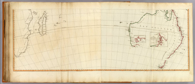
(Asia and its islands according to d'Anville; divided into empires, kingdoms, states, regions, &c. &c. with the European possessions and settlements in the East Indies and an exact delineation of all the discoveries made in the eastern parts by the English under Captn. Cook, Vancouver & Peyrouse. South sheets. London, Publish'd by Laurie & Whittle, No. 53, Fleet Street, Feby. 2d, 1799)
List No
2310.054
Note
Digital composite of hand colored engraved map. Relief shown pictorially. Inset maps: Sketch of King Geo. IIIds Sound -- The discoveries made by the ship Duke on the south extremity of New Holland in 1791. Printed on 2 sheets; joined.
Author
[Anville, Jean Baptiste Bourguignon d, 1697-1782, Robert Laurie & James Whittle]
Full Title
A new map of Turkey in Asia by Monsr. d'Anville, First Geographer to the most Christian King with several additions. London, Published by Laurie & Whittle, No. 53, Fleet Street, as the act directs 12th May, 1794.
List No
2310.056
Note
Hand colored engraved map. Relief shown pictorially.
Author
[Anville, Jean Baptiste Bourguignon d, 1697-1782, Niebuhr, Carsten, Robert Laurie & James Whittle]
Full Title
A new map of Arabia divided into its several regions and districts. From Monsr. d'Anville, Geographer to the most Christian King with additions and improvements from Mr. Niebuhr. London, Published by Laurie & Whittle, 53 Fleet Street, as the act directs 12th May, 1794.
List No
2310.057
Note
Hand colored engraved map. Relief shown pictorially. Prime meridian: Ferro.
Author
[Anville, Jean Baptiste Bourguignon d, 1697-1782, Robert Laurie & James Whittle]
Full Title
A new map of the Empire of Persia from Monsr. D'Anville, First Geographer to the most Christian King, with several additions and emendations. London, Published by Laurie & Whittle, 53, Fleet Street, as the act directs 12th May, 1794.
List No
2310.058
Note
Hand colored engraved map. Relief shown pictorially. Prime meridian: Ferro.
Author
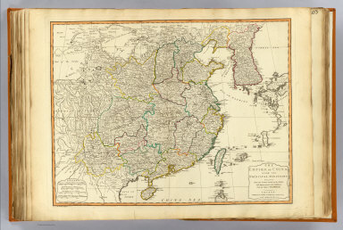
[Anville, Jean Baptiste Bourguignon d, 1697-1782, Robert Laurie & James Whittle]
Full Title
The Empire of China, with its principal divisions; drawn from the surveys made by the Jesuits; with improvements and additions, from the maps of Monsr. D'Anville. London, Published by Laurie & Whittle, 53 Fleet Street, as the act directs 12th May, 1794. M. Bowen, sculpt.
List No
2310.070
Note
Hand colored engraved map. Relief shown pictorially.
Author
[Anville, Jean Baptiste Bourguignon d, 1697-1782, Jefferys, Thomas, Sayer, Robert]
Full Title
The western coast of Africa from Cape Blanco to Cape Virga, exhibiting Senegambia Proper. By T. Jefferys, Geographer to his Majesty. London, Printed by Robt. Sayer, No. 53, Fleet Street, 1789.
List No
2310.075
Note
Hand colored engraved map. Relief shown pictorially; depths shown by soundings. "This map is copied from an original drawn by Monsr. D'Anville at the expence of the French East India Company & published at Paris." Has illustrated cartouche. Includes text.
Author
Robert Laurie & James Whittle
Full Title
(A new map of the whole continent of America, divided into north and south and West Indies. North half. Wherein are exactly described the United States of North America as well as the several European possessions according to the Preliminaries of Peace signed at Versailles Jan. 20, 1783. Compiled from Mr. d'Anville's maps of that continent, with the addition of the Spanish discoveries in 1775 to the north of California & corrected in the several parts belonging to Great Britain, from the original materials of Governor Pownall, MP. London, Publish'd by Laurie & Whittle, No. 53, Fleet Street, as the act directs 12th May, 1794)
List No
2310.077
Note
Hand colored engraved map. Relief shown pictorially. Shows colonies, cities, Indian tribes, rivers, etc. Includes table: The continent and islands of America as divided and possessed ... Prime meridian: Ferro. Printed on 2 sheets; joined.
Author
[Anville, Jean Baptiste Bourguignon d, 1697-1782, Pownall, Thomas, Robert Laurie & James Whittle]
Full Title
A new map of the whole continent of America, divided into north and south and West Indies. (South half). (with) The supplement to North America containing the countries adjoining to Baffins & Hudsons bays. Wherein are exactly described the United States of North America as well as the several European possessions according to the Preliminaries of Peace signed at Versailles Jan. 20, 1783. Compiled from Mr. d'Anville's maps of that continent, with the addition of the Spanish discoveries in 1775 to the north of California & corrected in the several parts belonging to Great Britain, from the original materials of Governor Pownall, MP. London, Publish'd by Laurie & Whittle, No. 53, Fleet Street, as the act directs 12th May, 1794.
List No
2310.078
Note
Hand colored engraved map with inset. Relief shown pictorially. Shows colonies, cities, Indian tribes, rivers, etc. Includes table: The continent and islands of America as divided and possessed ... Illustrated cartouche. Prime meridian: Ferro. Printed on 2 sheets; joined.
Author
[Anville, Jean Baptiste Bourguignon d, 1697-1782, Robert Laurie & James Whittle]
Full Title
A new and complete map of the West Indies. Comprehending all the coasts and islands known by that name. By Monsr. Danville; with several emendations and improvements. London, Published by Laurie & Whittle, 53 Fleet Street, 12th May, 1794.
List No
2310.083
Note
Hand colored engraved map. Relief shown pictorially. Covers Mexico, Central America, the southern U.S., and northern South America. Prime meridians: Ferro and London.
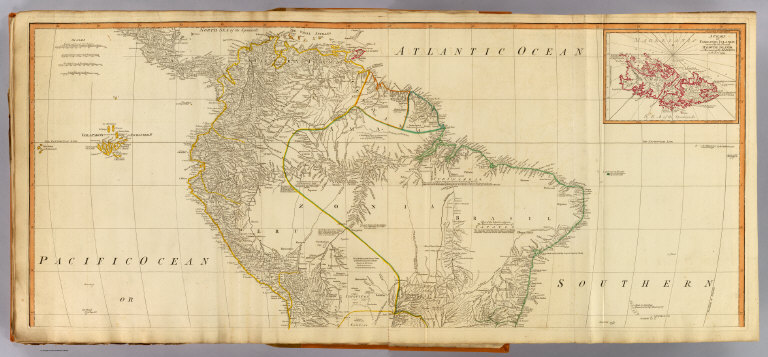
Full Title
(A map of South America containing Tierra-Firma, Guayana, New Granada, Amazonia, Brasil, Peru, Paraguay, Chaco, Tucuman, Chili and Patagonia, from Mr. d'Anville with several improvements and additions, and the newest discoveries. North half. (with) A chart of Falkland's Islands named by the French Malouine Islands and discovered by Hawkins, in the year 1593. London, Published by Laurie & Whittle, No. 53 Fleet Street, as the act directs 12th May, 1794)
List No
2310.089
Note
Hand colored engraved map with inset. Relief shown pictorially; depths by soundings. Shows settlements, roads, Indian tribes, etc. Includes descriptive notes. Prime meridian: Ferro. Printed on 2 sheets; joined.
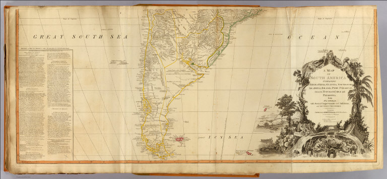
Author
[Anville, Jean Baptiste Bourguignon d, 1697-1782, Robert Laurie & James Whittle]
Full Title
A map of South America containing Tierra-Firma, Guayana, New Granada, Amazonia, Brasil, Peru, Paraguay, Chaco, Tucuman, Chili and Patagonia, from Mr. d'Anville with several improvements and additions, and the newest discoveries. (South half). London, Published by Laurie & Whittle, No. 53 Fleet Street, as the act directs 12th May, 1794.
List No
2310.090
Note
Hand colored engraved map. Relief shown pictorially; depths by soundings. Shows settlements, roads, Indian tribes, etc. Includes text "Divisions of South America with a summary account of its trade," descriptive notes and illustrated cartouche. Prime meridian: Ferro. Printed on 2 sheets; joined.
Author
Anville, Jean Baptiste Bourguignon d, 1697-1782
Full Title
Hemisphere Occidental ou du Nouveau Monde. Hemisphere Oriental ou de l'Ancien Monde. Publie sous les auspices de Monseigneur Louis Philippe, Duc d'Orleans, Premieu Prince du Sang. Par le Sr. d'Anville, de l'Academie Royale des Belles Lettres, et de celle des Sciences de Petersbourg, Secretaire de S? Alt? Ser? MDCCLXI. Sous le Privilege de l'Academie.
List No
2603.001
Note
"Double hemisphere engraved map on 2 sheets. Relief shown pictorially. Continental boundaries hand col. ""1"" added by hand on verso."
Author
Anville, Jean Baptiste Bourguignon d, 1697-1782
Full Title
Premiere partie de la Carte d'Europe contenant la France, l'Alemagne, l'Italie, l'Espagne & les Isles Britanniq(ue)s. Publiee sous les auspices de Monseigneur Louis Philippe d'Orleans, Duc d'Orleans et Premier Prince de Sang. Par le Sr. d'Anville de l'Academie Royale des Belles Lettres, et du celle des Sciences de Petersbourg, Secretaire de on. Alt. Seren? (Grave par) G. De la Haye. (Paris : Sr. d'Anville), MDCCLIV.
List No
2603.002
Note
Engraved map on 2 sheets. Relief shown pictorially. Ornamental cartouche by "N. Le Mire scul." Includes inset map. David Rumsey Collection mounted as 1 sheet. Political division boundaries hand col. "2" added by hand on verso.
Author
Anville, Jean Baptiste Bourguignon d, 1697-1782
Full Title
Seconde partie de la carte d'Europe, contenant le Danemark et la Norwege, la Suede et la Russie (a l'exception de l'Ukraine). Publiee sous les auspices de Monseigneur Louis Philippe d'Orleans, Duc d'Orleans, Premier Prince du Sang. Par le Sr. d'Anville, de l'Academie Rle. des Belles-Lettres, et de celle des Sc? de Petersbourg, Secretaire de Son Alt? Seren?. Grave par G. De la Haye. Sous le Privilege de l'Academie, chez l'Auteur, aux Galeries du Louvre, MDCCLVIII.
List No
2603.003
Note
Engraved map on 2 sheets. Relief shown pictorially. Ornamental cartouche by "N. Le Mire sculp." Includes inset map of Iceland. David Rumsey Collection mounted as 1 sheet. Political division boundaries hand col. "3" added by hand on verso.
Author
Anville, Jean Baptiste Bourguignon d, 1697-1782
Full Title
Troisieme partie de la carte d'Europe, contenant le midi de la Russie, la Pologne, et la Hongrie, la Turquie y compris celle d'Asie presqu'entiere. Publiee sous les auspices de Monseigneur Louis Philippe d'Orleans, Duc d'Orleans, Premier Prince du Sang. Par le Sr. d'Anville, de l'Academie Rle. des Belles Lettres, et de celle des Sc? de Petersbourg, Secretaire de Son Alt? Seren? (Grave par) De la Haye. Sous le Privilege de l'Academie, chez l'Auteur aux Galerie du Louvre, MDCCLX.
List No
2603.004
Note
Engraved map on 2 sheets. Relief shown pictorially. Ornamental cartouche by "J.P. Cheffard sculp." David Rumsey Collection mounted as 1 sheet. Political division boundaries hand col. "4" added by hand on verso.
Author
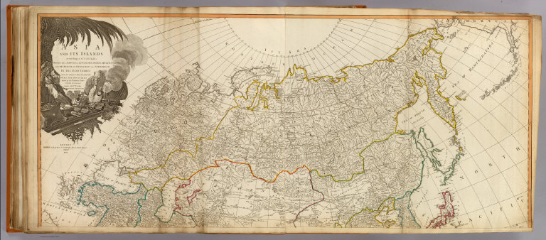
Anville, Jean Baptiste Bourguignon d, 1697-1782
Full Title
Premiere partie de la carte d'Asie, contenant la Turquie, l'Arabie, la Perse, l'Inde en deca du Gange et de la Tartarie, ce qui est limitrophe de la Perse et de l'Inde. Publiee sous les auspices de Monseigneur le Duc d'Orleans, Premier Prince du Sang. Par le Sr. d'Anville, MDCCLI. Grave par Guille. De-la-Haye. A Paris, ches l'Auteur aux Galeries du Louvre, avec Privil?
List No
2603.005
Note
Engraved map on 2 sheets. Country boundaries hand col. Relief shown pictorially. Includes geographic notes and ornamental cartouche by "H. Gravelot, invenit., DeLafosse, sculpsit." David Rumsey Collection copy mounted as 1 sheet. Hand numbered "5" on verso.
Author
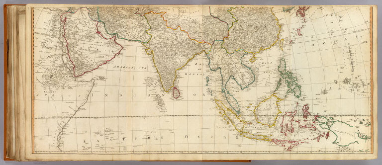
Anville, Jean Baptiste Bourguignon d, 1697-1782
Full Title
Seconde partie de la carte d'Asie, contenant la Chine et partie de la Tartarie, l'Inde au dela du Gange, les isles Sumatra, Java, borneo, Moluques, Philippines, et du Japon. Publiee sous les auspices de Monseigneur Louis-Philippe d'Orleans, Duc d'Orleans, Premier Prince du Sang. Par le Sr. d'Anville, Secretaire de Son Alt? Sereniss? Guill? De la Haye Scul. A Paris, chez l'Auteur, aux Galeries du Louvre. M.DCC.LII.
List No
2603.006
Note
Engraved map on 2 sheets. Country boundaries hand col. Relief shown pictorially. Includes geographic notes and ornamental cartouche. David Rumsey Collection copy mounted as 1 sheet. Hand numbered "6" on verso.
Author
Anville, Jean Baptiste Bourguignon d, 1697-1782
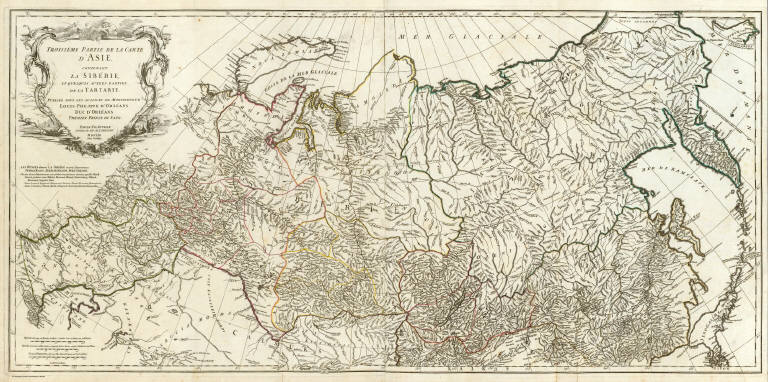
Full Title
Troisieme partie de la carte d'Asie, contenant la Siberie, et quelques autres parties de la Tartarie. Publiee sous les auspices de Monseigneur Louis-Philippe d'Orleans, Duc d'Orleans, Premier Prince du Sang. Par le Sr. d'Anville, Secretaire de Son. Alt? Sereniss? Guill? De la Haye (sculp. A Paris, chez l'Auteur, aux Galeries du Louvre). M DCC LIII.
List No
2603.007
Note
Engraved map on 2 sheets. Country boundaries hand col. Relief shown pictorially. Includes geographic notes and ornamental cartouche by "H. Gravelot, invenit., DeLafosse sculpsit." David Rumsey Collection copy mounted as 1 sheet. Hand numbered "7" on verso.
Author
Anville, Jean Baptiste Bourguignon d, 1697-1782
Full Title
Afrique. (Northern section). Publiee sous les auspices de Monseigneur le Duc d'Orleans, Premier Prince du Sang. Par le Sr. d'Anville, M DCC XLIV. Avec Privilege. (Grave par Guill. Delahaye). A Paris, ches l'Auteur aux Galeries du Louvre.
List No
2603.008
Note
Engraved map on 2 sheets. Country boundaries hand col. Relief shown pictorially. Includes inset map of the Azores, geographic notes and ornamental cartouche. David Rumsey Collection copy mounted as 1 sheet. "No.9 Afrique 1" added by hand on verso.
Author
Anville, Jean Baptiste Bourguignon d, 1697-1782
Full Title
(Afrique. Southern section. Publiee sous les auspices de Monseigneur le Duc d'Orleans, Premier Prince du Sang. Par le Sr. d'Anville, M DCC XLIV. Avec Privilege). Grave par Guill. Delahaye. (A Paris, ches l'Auteur aux Galeries du Louvre)
List No
2603.009
Note
Engraved map on 2 sheets. Country boundaries hand col. Relief shown pictorially. Includes geographic notes. David Rumsey Collection copy mounted as 1 sheet. "No. 9 Afrique 2" added by hand on verso.
|