|
Author
Anonymous
Full Title
Plano de la Ciudad y Puerto de Acapulco
List No
15781.000
Note
Date estimated.
Author
Anonymous
Full Title
青康藏公路 (Qingkang-Tibet Highway.)
List No
15841.000
Author
Anonymous
Full Title
Manuscript Map
List No
15645.002
Note
"On the verso is an unfinished manuscript map that depicts a locality, with all details unlabelled, with sub-jurisdictions outlined in the own bright hues, and a river running through it, while a legend, upper-right, defines unused symbols. We have not been able to identify the subject of the map, and even whether it pertains in any way to Taiwan. However, the note in the lower right, seems to refer to “Nagai Village”, which if true might refer to a town in the Yamagata Prefecture of north-central Japan. This is perhaps a matter for further research." (See Pub note)
Author
Anonymous
Full Title
Meridian Highway. U.S. 81 Throughout. The Main Street of North America.
List No
15557.000
Author
Anonymous
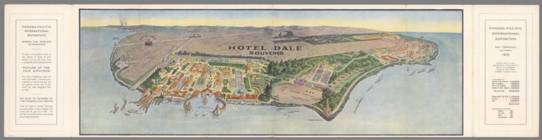
Full Title
(Covers to) San Francisco 1915 Hotel Dale Souvenir.
List No
15475.001
Author
Anonymous
Full Title
San Francisco 1915 Hotel Dale Souvenir.
List No
15475.002
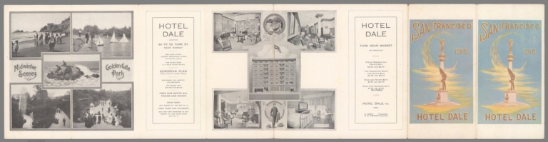
Author
Anonymous
Full Title
(Text page to) San Francisco 1915 Hotel Dale Souvenir.
List No
15475.003
Author
Anonymous
Full Title
(Covers to) (Russia) Europaeischer Teil Der UdSSR Bilderkarte
List No
15262.001
Note
Date estimated.
Author
Anonymous
Full Title
(Russia) Europaeischer Teil Der UdSSR Bilderkarte
List No
15262.002
Note
Date estimated.
Author
[Anonymous, Borgia, Cardinal Stefano]
Full Title
[Medieval Mappa Mundi] Apographon descriptionis Orbis terrae, figuris et narratiunculis distinctae, Manu Germanica opere nigelliari discoloriocirca medium Saec. XV. Tabulae aeneae Musei Borgiani Velitris..
List No
15161.000
Author
Anonymous
Full Title
(Covers to) Yahoo! Internet Life Science Fiction Star Map
List No
15117.001
Author
Anonymous
Full Title
Yahoo! Internet Life Science Fiction Star Map
List No
15117.002
Author
Anonymous
Full Title
Antartide continente del giorno
List No
15112.000
Author
Anonymous
Full Title
園地新市阪大 園と圏波難前車七拾四百四阪大 (Osaka Fifth National Industrial Exhibition)
List No
15101.000
Author
Anonymous
Full Title
(Covers to) 市區改正東亰實測全圖 / [Complete Survey Map of Tokyo with Revised Wards].
List No
15002.001
Author
Anonymous
Full Title
市區改正東亰實測全圖 / [Complete Survey Map of Tokyo with Revised Wards].
List No
15002.002
Author
Anonymous
Full Title
Le Plan de Cinema à Paris
List No
15015.001
Note
Date estimated.
Author
Anonymous
Full Title
Europe Movie Map
List No
15015.002
Note
Date estimated. Verso of the Le Plan de Cinema à Paris
Author
Anonymous
Full Title
Dağlar ve dakjez lar ... = Mountains and seas. Alps daglerink = Alps daglerink ... اغلر ودكزار
List No
13531.000
Author
Anonymous
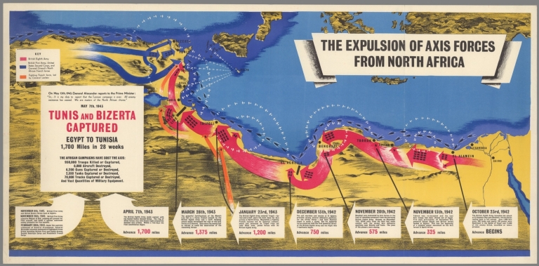
Full Title
The Expulsion Of Axis Forces From North Africa
List No
10746.000
Author
Anonymous
Full Title
(Covers to) Air Afrique.
List No
10672.001
Note
Date estimated. DC 10 airplanes released 1971.
Author
Anonymous
Full Title
Air Afrique.
List No
10672.003
Note
Date estimated. DC 10 airplanes released 1971.
Author
Anonymous
Full Title
Plan of Cape Breton.
List No
10666.000
Author
Anonymous
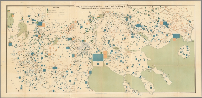
Full Title
Carte Ethnographique de la Macédoine Grecque Representant la Repartition Ethnique au mois d’août 1915.
List No
10628.000
Author
Anonymous
List No
10443.000
Author
Anonymous
Full Title
(Current status of U.S. Navy in the Pacific War.)
List No
13104.000
Note
Color map in Japanese, with 2 insets legend and notes. Date estimated. Showing the areas of the conflict, war planes, battle ships and distances.
Author
Anonymous
Full Title
Bunkyu 3 (1863 map of Kyoto, Japan).
List No
13123.002
Note
Woodblock Japanese map of Kyoto on sheet 45x69, folded in covers with cover title, dated Bunkyū 3 [1863]. Relief shown pictorially. Includes legend. Covers all of Kyoto as well as some of the surrounding hills. Printed in the traditional Japanese style popular during the Edo Period, with topography shown in profile, no directional orientation. Early Japanese cartography has its own very distinctive projection and layout system. This era, from the 1600s to c. 1855, which roughly coincides with the Tokugawa or Edo Period (1603-1886), some consider the Golden Age of Japanese Cartography. Map shows city blocks, rivers, mountains, lakes and some buildings.
Author
Anonymous
Full Title
(Japan, Korea, and Taiwan.)
List No
8851.000
Note
Date estimated.
Author
Anonymous
Full Title
Kaliforniya. (Kalifornia) Verkhnyaya Kaliforniya.
List No
11957.000
Note
Engraved map in Russian of Northern California and Mexico, Baja California. Shows international and administrative boundaries, cities, towns, rivers and mountains. Relief shown by hachures. Date is estimated based on showing of Pyramid Lake from the Fremont 1845 map. The map appears to have been published in Russia as a separate map, not in any reports we can locate. It shows the Russian settlement at Fort Ross on the California coast. It might have been a map advocating for increased Russian exploration and settlement in California. There is no mention of the gold rush on the map, thus it is likely to have been published before 1849. We have not been able to located any other copies at libraries.
Author
Anonymous
Full Title
Despues de tres anos de victorias Septiembre 1939 - Septiembre 1942. WPr / IV. E - Nr. 24-IX / 1942-Er.
List No
11808.000
Note
German propaganda map of the world in Spanish, celebrating the German and Japanese success in World War II from September 1939 to September 1942 after 3 victorious years and their role as the Liberators of the new young vibrant peoples of Europe and Asia. The map illustrates the dual assaults of Germany and Japan in the eastern and western theaters. Includes 2 insets, explanatory text and legend describing the conventional signs.
Author
Anonymous
Full Title
(Taisho Japanese map of the world. Taisho Japanese map of Japan and Korea). (9 insets).
List No
11670.000
Note
Wall map of the world commemorating Japanese involvement in World War I on sheet 190x87. Mounted on bamboo rods framed with decorative cloth. In 2 parts: The upper part showing double hemisphere projection map of the world, omitting the Antarctic and any small islands, with numerous portraits of world leaders, most of whom were in power during the first world war. At center is an image of the Japanese Emperor Taisho. The top left corner is an image of someone made to look like Emperor Jimmu, the 1st emperor of Japan. The top right corner is an image of Emperor Meji (1868 – 1912), who preceded Taisho and is known for moving the capitol to Edo (present day Tokyo). Other world leaders shown above the map include King George V (Great Britain) Tsar Nicolas II (Russia), Sultan Mehmed V (Ottoman), Franz Joseph (Austria – Hungary), Woodrow Wilson (United States of America), and Albert I (Belgium), to name a few. The lower part Includes map of Japan and Korea with 9 insets: including map of the world during WWI, map of Taiwan, map of the north extension of Kurile Islands, etc. Includes legend. Date estimated 1918.
Author
Anonymous
Full Title
De Roemryke Verdediging van de Citadel van Antwerpen in de maand December 1832, National Gedenkteeken aan ... Willem den Eersten.
List No
12385.000
Note
Date estimated.
Author
Anonymous
Full Title
Shinkoku Taihei Take Mori Mata Akira.
List No
11528.000
Note
Wood block print, pictorial map of the coast defense of Tokyo Bay. Kawaraban Broadside Map depicting arrival of Perry's "Black Ships," describing the arrival of the American Commodore Matthew Perry to Edo Bay (Tokyo Bay) in 1854 (Kaei 6), after his earlier brief visit in 1853. The defensive ships identified by the warlord in charge and his armorial crest are around the bay to intimidate the invaders. Includes notes describing the troops and list of names of Samurais in charge of defense of Tokyo Bay. Includes an illustration in the upper right depicting an American soldier. Perry's ships were the first major western intrusion into Japan. “Perry, on behalf of the U.S. government, forced Japan to enter into trade with the United States and demanded a treaty permitting trade and the opening of Japanese ports to U.S. merchant ships. This was the era when all Western powers were seeking to open new markets for their manufactured goods abroad, as well as new countries to supply raw materials for industry. It was clear that Commodore Perry could impose his demands by force. The Japanese had no navy with which to defend themselves, and thus they had to agree to the demands… Upon seeing Perry's fleet sailing into their harbor, the Japanese called them the "black ships of evil mien (appearance)." Many leaders wanted the foreigners expelled from the country, but in 1854 a treaty was signed between the United States and Japan which allowed trade at two ports. In 1858 another treaty was signed which opened more ports and designated cities in which foreigners could reside. The trade brought much foreign currency into Japan disrupting the Japanese monetary system. Because the ruling shogun seemed unable to do anything about the problems brought by the foreign trade, some samurai leaders began to demand a change in leadership. The weakness of the Tokugawa shogunate before the Western demand for trade, and the disruption this trade brought, eventually led to the downfall of the Shogunate and the creation of a new centralized government with the emperor as its symbolic head.” Source: Asia for Educators, Columbia University.
Author
Anonymous
Full Title
Vue de Paris du haut du Pavillon de Flore aux Tuileries.
List No
11540.000
Note
Copper engraving circular map panoramic view of Paris from the top of Pavillon de Flore. Includes most important landmarks and buildings, river, mountains and bridges. Date estimated based on number 34: Quai d'Orsay on the map is named Quai Bonaparte. the quay was only called Bonaparte between 1808-1815. Includes a key showing the areas depicted by the map.
Author
Anonymous
Full Title
SAS Spiral-Polar Projection. Created Especially for Scandinavian Airlines System to Illustrate Its Worldwide Routes.
List No
8976.000
Note
Date estimated.
Author
Anonymous
Full Title
United States.
List No
5442.000
Note
Outline color hand drawn map by a young student. A silk blue border has been sown onto map with silk hooks for hanging. Date estimated from geography of the west.
Author
Rambo, F. Ralph
Full Title
Cartoon Pen & Inklings of the Old Santa Clara Valley.
List No
10502.000
Note
Date estimated.
Author
Anonymous
Full Title
(Text page to) Air Afrique.
List No
10672.002
Note
Date estimated. DC 10 airplanes released 1971.
Author
Anonymous
Full Title
Saishin Oshu daichizu : tsuketari rekkyo kokusei kokubo ichiran. Kingu Henshukyoku. Showa 10 (1935). (at upper margin) Kingu dai 20-kan dai 1-go furoku.
List No
11109.000
Note
Color map. Covers North Atlantic Ocean, Europe, North Africa, part of Asia, with 3 insets. of double Hemispheres, and Europe. Published as supplement to vol.20, no.1 of magazine 'Kingu'. Sows political divisions, major cities, military figures, air and sea routes and distances, roads, railroads, etc.. includes charts, graphs, and legend. Relief shown by hachures.
Author
Anonymous
Full Title
(Korean Celestial and zodiacal constellation chart).
List No
11806.001
Note
Early manuscript star chart integrating Korean, Chinese, and western astronomical science, with title on verso, on sheet 85x81. Date estimated. Originally engraved in a stone stele. Showing rank and distribution of Stars, illustrates the traditional Chinese zodiacal system, following the Cheonsang Yeolcha Bunyajido, a fourteenth -centuray Korean star map, but also incorporating western zodiacal astrology, and Qian Lezhi's c. 440 AD Chinese celestial globe illustrating the work of the ancient Chinese astronomers Shi Shen, Gan De, and Wu Xian. Following Qian Lezhi's c. system the constellations of the three great astronomers are distinguished. Constellations appearing in black reference Gan De, constellations in red reference Shi Shen, open circles reference Wu Xia. Two larger intersecting circles surround the center, represent the ecliptic and Equator. The chart is further divided into numerous xiu, surrounding a central nexus. The nexus, represented by a circle at the center of the map, represents Earthly life. The other constellations are divided into zones typically referred to as xiu or mansions. In traditional Chinese celestial cartography there are 28 unequal mansions, presumably associated with lunar movements. This chart, for no clear reason, consolidates several of the smaller mansions into larger entities, leaving only 24. This chart also illustrates the Milky Way, a feature uncommon to Chinese charts, but not atypical on Korean charts from the 14th century onwards, when it first appeared on the Cheonsang Yeolcha Bunyajido. Around the outside of the map the constellations of the western Zodiac, and the seasons, are named. An exceptionally rare and important discovery.
Author
Anonymous
Full Title
(Title Page to) (Korean Celestial and zodiacal constellation chart).
List No
11806.002
Note
Early manuscript star chart integrating Korean, Chinese, and western astronomical science, with title on verso, on sheet 85x81. Date estimated. Originally engraved in a stone stele. Showing rank and distribution of Stars, illustrates the traditional Chinese zodiacal system, following the Cheonsang Yeolcha Bunyajido, a fourteenth -centuray Korean star map, but also incorporating western zodiacal astrology, and Qian Lezhi's c. 440 AD Chinese celestial globe illustrating the work of the ancient Chinese astronomers Shi Shen, Gan De, and Wu Xian. Following Qian Lezhi's c. system the constellations of the three great astronomers are distinguished. Constellations appearing in black reference Gan De, constellations in red reference Shi Shen, open circles reference Wu Xia. Two larger intersecting circles surround the center, represent the ecliptic and Equator. The chart is further divided into numerous xiu, surrounding a central nexus. The nexus, represented by a circle at the center of the map, represents Earthly life. The other constellations are divided into zones typically referred to as xiu or mansions. In traditional Chinese celestial cartography there are 28 unequal mansions, presumably associated with lunar movements. This chart, for no clear reason, consolidates several of the smaller mansions into larger entities, leaving only 24. This chart also illustrates the Milky Way, a feature uncommon to Chinese charts, but not atypical on Korean charts from the 14th century onwards, when it first appeared on the Cheonsang Yeolcha Bunyajido. Around the outside of the map the constellations of the western Zodiac, and the seasons, are named. An exceptionally rare and important discovery.
Author
Anonymous
Full Title
Birthplace of great composers. O. W. J.
List No
11948.000
Note
Pictorial hand colored map by country, with no publisher and publication date. Covers North America, and Europe, covers portion of Asia Africa, South America and Australia. With music scores at its borders, title cartouche and numerous illustrations of animals, people, ships and sea monsters. Includes decorative compass roses. singed by O.W.J. at the right lower corner. Date estimated.
Author
Anonymous
Full Title
Guide map of the city & county of San Francisco : compiled from latest official surveys. Corrected and revised up to date.
List No
11950.000
Note
Map of San Francisco. Shows built-up areas, ranchos, some block numbers, streets, roads, drainage, wards, railroads, parks, etc. Date estimated.
Author
Anonymous
Full Title
Kunst und Technik: Mitteleuropa, per Computer farbverfremdet (Art and Technology: Central Europe, by computer color-alienated). Micro Computer Welt, Die prackische Anwendung Kleiner Computer (Microcomputer World, The practical use Small Computer).
List No
12111.000
Author
Anonymous
Full Title
Evangeline Tour (Louisiana). Florida Parishes Tour (Florida).
List No
12335.001
Author
Anonymous
Full Title
A Tourist Map Of Louisiana.
List No
12335.002
Note
Color.
Author
Anonymous
Full Title
Guide to the Western Pacific.
List No
12343.000
Note
Date estimated.
Author
Anonymous
Full Title
Panorama of the Great Lakes Exposition.
List No
12370.000
Note
Date estimated. Bird's eye view.
Author
Anonymous
Full Title
Persian Gulf Command. Cartographical Map of Iran Once Known as Persia, 1322-1944, Showing Many Places of Biblical and Historical Interest.
List No
12377.000
Author
Anonymous
Full Title
(Coves to) Map of Doniphan County, Kansas. Showing the location of Highland.
List No
13037.001
Note
Map of Highland and neighboring towns, in Doniphan county, Kansas, Folds into a manuscript cover page document with three signatures, concerning the drawing of lots to be awarded to the various share holders that held stock in the town. Includes an embossed stamp from Highland University, established for the Sac and Fox National Indian Tribe in 1837.
|


![[Medieval Mappa Mundi] Apographon descriptionis Orbis terrae, figuris et narratiunculis distinctae, Manu Germanica opere nigelliari discoloriocirca medium Saec. XV. Tabulae aeneae Musei Borgiani Velitris..](https://www.davidrumsey.com/rumsey/Size1/RUMSEY~8~1/199/15161000.jpg)


![Covers: 市區改正東亰實測全圖 / [Complete Survey Map of Tokyo with Revised Wards].](https://www.davidrumsey.com/rumsey/Size1/RUMSEY~8~1/195/15002001.jpg)
![市區改正東亰實測全圖 / [Complete Survey Map of Tokyo with Revised Wards].](https://www.davidrumsey.com/rumsey/Size2/RUMSEY~8~1/195/15002002.jpg)