|
REFINE
Browse All : Atlas Map by Anonymous
1-50 of 50
Author
Anonymous
Full Title
Plano de la Isla de Lobos de Tierra mostrando Los depositos Huano. (to accompany) Las Islas de Huano. Paris. Impr. Lemercier.
List No
11864.002
Note
Plan of the Lobos de Tierra Islands. Showing the area with Guano deposits in orange. Includes notes.
Author
Anonymous
Full Title
Islas de Lobos Tierra. Deposito. B. (to accompany) Las Islas de Huano. Paris. Impr. Lemercier.
List No
11864.004
Note
Map of the Lobos de Tierra Islands. Part B. Showing the area with Guano deposits in orange. Includes explanation. Relief shown by hachures and form lines.
Author
Anonymous
Full Title
Plano de la Isla de Lobos de "Afuera" demostrado los depositos de Huano. (to accompany) Las Islas de Huano. Paris. Impr. Lemercier.
List No
11864.007
Note
Plan of Lobos de Afuera Islands. Showing the deposits of Guano in orange. Includes notes and 2 profile views of the islands at the lower panel. Prime meridian is Paris. Depth shown by soundings.
Author
Anonymous
Full Title
(Playing card maps). 1-4. Europe. France. Angleterre.
List No
11295.002
Note
12 pictorial hand colored game cards, each mounted on a heavy cardboard, backed with decorative cloth. Each card organized as a set of playing cards, includes 3 geographical maps of the major countries and continents of the world, and a portrait showing the costume of the area covered. Each map showing capitals and major cities. Date estimated.
Author
Anonymous
Full Title
Malte. (Valletta Harbor.)
List No
12191.002
Note
Date estimated. North down on map. The date is based on the showing of Fort Ricasoli, which was begun in 1670 and completed in 1698.
Author
Anonymous
Full Title
(Facsimile) Van Petten? - [1598?]. S Doc 91 55 2. 57. Sketch of the Island of Cayenne and of the Coast between the Caw and Macuria Rivers in Eastern Guiana, [1598?] Reproduced from a Tracing of the Original Manuscript in the Rijksarchief at the Hague, No. 675 of the Catalogue. Photo. Lith. by A. Hoen & Co., Baltimore, MD.
List No
1122.062
Note
Date estimated. Tinted boundaries.
Author
Anonymous
Full Title
Van Petten - 1598. S Doc 91 55 2. 58. Sketch of the Gulf of Paria, with Part of the Coast of Trinidad and of the Orinoco Delta, 1598. Reproduced from a Tracing of the Original Manuscript in the Rijksarchief at the Hague, No. 578 of the Catalogue. Photo. Lith. by A. Hoen & Co., Baltimore, MD.
List No
1122.063
Author
Anonymous
Full Title
Anonymous - [1735?]. S Doc 91 55 2. 72. Sketch Map of the Capuchin Missions in the Province of Guayana about 1765. Map I. Reproduced by Photo-lithography from the Original in the Capuchin Archives in Rome. Sketch Map of the Missions of the Catalonian Capuchins in the Spanish Province of Guayana, about 1735 (Rather than 1765). Reproduced from a Photolithographic Facsimile of the Manuscript Original in the Archives of the Capuchin Order at Rome given by Father Joseph Strickland, S.J., in his Documents nad Maps on the Boundary Question between Venzuela and British Guyana, Rome, 1898. Photo. Lith. by A. Hoen & Co., Baltimore, MD.
List No
1122.077
Note
Date estimated.
Author
Anonymous
Full Title
Anonymous [15--]. S Doc 91 55 2. 76. Mapa de los Rios Amazonas, Esequiyo o Dulche y Orinoca y de las Comarcas Adyacentes. Reproducido por la lit. del Instituto Geografico y Estadistico Ano de 1877. Early Spanish Map of Guiana, Reproduced from Lithographic Facsimile of the Manuscript Original in the Spanish Archives, Published by the Spanish Government in Cartes de Indias (Madrid, 187).
List No
1122.081
Note
Date estimated. Indicated to be the earliest known special map of this region.
Author
Anonymous
Full Title
(Playing card maps). 5-8. Russie Europeenne. Autriche. Prusse.
List No
11295.003
Note
12 pictorial hand colored game cards, each mounted on a heavy cardboard, backed with decorative cloth. Each card organized as a set of playing cards, includes 3 geographical maps of the major countries and continents of the world, and a portrait showing the costume of the area covered. Each map showing capitals and major cities. Date estimated.
Author
Anonymous
Full Title
(Playing card maps). 9-12. Espagne. Italie. Pays-Bas.
List No
11295.004
Note
12 pictorial hand colored game cards, each mounted on a heavy cardboard, backed with decorative cloth. Each card organized as a set of playing cards, includes 3 geographical maps of the major countries and continents of the world, and a portrait showing the costume of the area covered. Each map showing capitals and major cities. Date estimated.
Author
Anonymous
Full Title
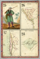
(Playing card maps). 13-16. Amerique. Etats Unis. Colombie.
List No
11295.005
Note
12 pictorial hand colored game cards, each mounted on a heavy cardboard, backed with decorative cloth. Each card organized as a set of playing cards, includes 3 geographical maps of the major countries and continents of the world, and a portrait showing the costume of the area covered. Each map showing capitals and major cities. Date estimated.
Author
Anonymous
Full Title
(Playing card maps). 17-20. Asie. Canada. Perse.
List No
11295.006
Note
12 pictorial hand colored game cards, each mounted on a heavy cardboard, backed with decorative cloth. Each card organized as a set of playing cards, includes 3 geographical maps of the major countries and continents of the world, and a portrait showing the costume of the area covered. Each map showing capitals and major cities. Date estimated.
Author
Anonymous
Full Title
(Playing card maps). 21-24.Turquie. Turquie Asiatique. Arabie.
List No
11295.007
Note
12 pictorial hand colored game cards, each mounted on a heavy cardboard, backed with decorative cloth. Each card organized as a set of playing cards, includes 3 geographical maps of the major countries and continents of the world, and a portrait showing the costume of the area covered. Each map showing capitals and major cities. Date estimated.
Author
Anonymous
Full Title
(Playing card maps). 25-28. Perou. Chili. Iles Canaries.
List No
11295.008
Note
12 pictorial hand colored game cards, each mounted on a heavy cardboard, backed with decorative cloth. Each card organized as a set of playing cards, includes 3 geographical maps of the major countries and continents of the world, and a portrait showing the costume of the area covered. Each map showing capitals and major cities. Date estimated.
Author
Anonymous
Full Title
(Playing card maps). 29-32. Chine. Indoustan. Japon.
List No
11295.009
Note
12 pictorial hand colored game cards, each mounted on a heavy cardboard, backed with decorative cloth. Each card organized as a set of playing cards, includes 3 geographical maps of the major countries and continents of the world, and a portrait showing the costume of the area covered. Each map showing capitals and major cities. Date estimated.
Author
Anonymous
Full Title
(Playing card maps). 33-36. Afrique. Sahara. Empire de Maroc.
List No
11295.010
Note
12 pictorial hand colored game cards, each mounted on a heavy cardboard, backed with decorative cloth. Each card organized as a set of playing cards, includes 3 geographical maps of the major countries and continents of the world, and a portrait showing the costume of the area covered. Each map showing capitals and major cities. Date estimated.
Author
Anonymous
Full Title
(Playing card maps). 37-40. Mexique. Buenos - Ayres. Bresil.
List No
11295.011
Note
12 pictorial hand colored game cards, each mounted on a heavy cardboard, backed with decorative cloth. Each card organized as a set of playing cards, includes 3 geographical maps of the major countries and continents of the world, and a portrait showing the costume of the area covered. Each map showing capitals and major cities. Date estimated.
Author
Anonymous
Full Title
(Playing card maps). 41-44. Sound ou Nigritie. Guinee. Congo.
List No
11295.012
Note
12 pictorial hand colored game cards, each mounted on a heavy cardboard, backed with decorative cloth. Each card organized as a set of playing cards, includes 3 geographical maps of the major countries and continents of the world, and a portrait showing the costume of the area covered. Each map showing capitals and major cities. Date estimated.
Author
Anonymous
Full Title
(Playing card maps). 45-48. Egypte. Barbarie. Abyssinie.
List No
11295.013
Note
12 pictorial hand colored game cards, each mounted on a heavy cardboard, backed with decorative cloth. Each card organized as a set of playing cards, includes 3 geographical maps of the major countries and continents of the world, and a portrait showing the costume of the area covered. Each map showing capitals and major cities. Date estimated.
Author
Anonymous
Full Title
Islas de Lobos Tierra. Deposito, A. (to accompany) Las Islas de Huano. Paris. Impr. Lemercier.
List No
11864.003
Note
Map of the Lobos de Tierra Islands. Part A. Showing the area with Guano deposits in orange. Includes explanation. Relief shown by hachures. Depth shown by soundings.
Author
Anonymous
Full Title
Islas de Lobos Tierra. Deposito. D. (to accompany) Las Islas de Huano. Paris. Impr. Lemercier.
List No
11864.005
Note
Map of the Lobos de Tierra Islands. Part D. Showing the area with Guano deposits in orange. Includes explanation. Relief shown by hachures.
Author
Anonymous
Full Title
Islas de Lobos Tierra. Deposito. E. (to accompany) Las Islas de Huano. Paris. Impr. Lemercier.
List No
11864.006
Note
Map of the Lobos de Tierra Islands. Part D. Showing the area with Guano deposits in orange. Includes explanation. Relief shown by hachures.
Author
Anonymous
Full Title
Isla de Lobos de Afuera : deposito No. 1. Isla de Lobos de Afuera : deposito : No.2. (to accompany) Las Islas de Huano. Paris. Impr. Lemercier.
List No
11864.008
Note
2 maps of Lobos de Afuera Islands on 1 sheet. Showing the deposits of Guano in orange. Includes explanation. Relief shown by hachures.
Author
Anonymous
Full Title
Isla de Lobos de Afuera : deposito No. 3. (to accompany) Las Islas de Huano. Paris. Impr. Lemercier.
List No
11864.009
Note
Map of Lobos de Afuera Islands. Showing the deposits of Guano in orange. Includes explanation. Relief shown by hachures and form lines.
Author
Anonymous
Full Title
Isla de Lobos de Afuera : deposito No. 4. (to accompany) Las Islas de Huano. Paris. Impr. Lemercier.
List No
11864.010
Note
Map of Lobos de Afuera Islands. Showing the deposits of Guano in orange. Includes explanation. Relief shown by hachures and form lines.
Author
Anonymous
Full Title
Isla de Lobos de Afuera : deposito No. 5. Isla de Lobos de Afuera : deposito No. 6. (to accompany) Las Islas de Huano. Paris. Impr. Lemercier.
List No
11864.011
Note
2 maps of Lobos de Afuera Islands on 1 sheet. Showing the deposits of Guano in orange. Includes explanation. Relief shown by hachures and form lines.
Author
Anonymous
Full Title
Isla de Lobos de Afuera : deposito No. 7. (to accompany) Las Islas de Huano. Paris. Impr. Lemercier.
List No
11864.012
Note
Map of Lobos de Afuera Islands. Showing the deposits of Guano in orange. Includes explanation. Relief shown by hachures and form lines.
Author
Anonymous
Full Title
Isla de Lobos de Afuera : deposito No. 8. (to accompany) Las Islas de Huano. Paris. Impr. Lemercier.
List No
11864.013
Note
Map of Lobos de Afuera Islands. Showing the deposits of Guano in orange. Includes explanation. Relief shown by hachures and form lines.
Author
Anonymous
Full Title
Plano de las Islas de Macabi. Mostrano. (to accompany) Las Islas de Huano. Paris. Impr. Lemercier.
List No
11864.014
Note
Plan of the Macabi Islands. Showing the Guano deposits. Includes notes and 2 profile views of the islands at the lower panel. Depth shown by soundings. Relief shown by hachures and form lines.
Author
Anonymous
Full Title
Plano de las Islas de Macabi. Mostrano. (to accompany) Las Islas de Huano. Paris. Impr. Lemercier.
List No
11864.015
Note
Plan of the Guanape Islands. Showing the Guano deposits. Includes notes and 3 profile views of the islands at the lower panel. Depth shown by soundings. Relief shown by hachures and form lines.
Author
Anonymous
Full Title
Isla del sur de Cuanape. (to accompany) Las Islas de Huano. Paris. Impr. Lemercier.
List No
11864.016
Note
Map of the South Island of Cuanape. Showing the Guano deposits. Relief shown by hachures.
Author
Anonymous
Full Title
Isla del sur de Cuanape. Deposito. A. (to accompany) Las Islas de Huano. Paris. Impr. Lemercier.
List No
11864.017
Note
Map of the South Island of Cuanape. Showing the Guano deposits.
Author
Anonymous
Full Title
Plan des Batailles Donnees le 15, 16, 17, et 18 Juin 1815 aux Environs de Bruxelles.
List No
12100.025
Note
Battle of Waterloo mapped and described.
Author
Anonymous
Full Title
Carte de l'Isle de France et Brie.
List No
12100.034
Author
Anonymous
Full Title
Alger.
List No
12100.057
Author
Anonymous
Full Title
(Cette) (Sete, France)
List No
12191.003
Note
Date estimated. Foldout. Not identified on the chart, but we determined this is very likely the port of Cette, (now Sete, France) based on the Roux chart of Cette, our 9742.020 and modern maps.
Author
Anonymous
Full Title
St. Sebastian. (San Sebastian.)
List No
12191.004
Note
Date estimated.
Author
Anonymous
Full Title
Civita Vequia. (Civitavecchia.)
List No
12191.005
Note
Date estimated.
Author
Anonymous
Full Title
(Barcelona, Spain)
List No
12191.006
Note
Date estimated. Chart untitled. We estimate that it is of Barcelona, Spain, based on comparison with the Roux chart of Barcelona, our 9742.014 and the Bellin chart of Barcelona, our 6903.413, both from 1764
Author
Anonymous
Full Title
Livorne. (Livorno.)
List No
12191.007
Note
Date estimated.
Author
Anonymous
Full Title
Port du Passage.
List No
12191.008
Note
Date estimated. Label pasted onto map.
Author
Anonymous
Full Title
(Port de Bouc, France)
List No
12191.009
Note
Date estimated. Chart is untitled, but is determined to be Port de Bouc, France based on the Roux chart of Bouc (see 9742.021) and modern maps.
Author
Anonymous
Full Title
(Unidentified Harbor.)
List No
12191.010
Note
Date estimated. Foldout.
Author
Anonymous
Full Title
Karte des europaeischen Russlandes.
List No
12378.004
Author
Anonymous
Full Title
Karte des evangelisch - lutherischen Gemeinen in dem Gouvernement St. Petersburg.
List No
12378.005
Author
Anonymous
Full Title
Die Kolonien in dem Gouvernements, Saratow und Samara.
List No
12378.006
Author
Anonymous
Full Title
Die Kolonien in Bessarabien und in dem Gouvernement Cherson.
List No
12378.007
Author
Anonymous
Full Title
Die Kolonien in den Gouvernements Jekaterinoslaw und Taurien. (inset) Die Kolonien in der Krimm.
List No
12378.008
Author
Anonymous
Full Title
The United States; North America; South America; Europe; Africa; Asia.
List No
5529.001
Note
Six maps made of stiff brown cardboard with country in outline, scale marker at the bottom and holes for the pinpointing of capitals and major cities.
1-50 of 50
|