|
REFINE
Browse All : National Atlas by Academie der Wissenschafften
1-47 of 47
Author
[Akademiia nauk SSSR, L'Isle, Joseph Nicolas de, Academie der Wissenschafften, Academy of Sciences, St. Petersburg]
Full Title
(Covers to) (Atlas Russicus) Russischer Atlas : Welcher in einer General-Charte und neunzehen Special-Charten das gesamte Russische Reich und dessen angraentzende Laender, nach den Regeln der Erd-Beschreibung und den ne Academie der Wissenschafften. St. Petersburg 1745. (Prepared under the direction of) Ivan Kirilov, and Joseph Nicolas Delisle.
List No
5825.001
Note
The first atlas of Russia, published by the Academy of Sciences in St. Petersburg, expanding on the cartographic work done previously by Ivan K. Kirilov. Postnikov: "It brings together all the geographical discoveries of the early 18th century to give a fuller picture of the entire Empire than shown in the so-called Kirilov atlas. The maps were mostly based on instrumental surveys, geographical descriptions and maps compiled by the Petrine geologists and their successors." Normally the atlas includes 20 maps; this copy is special in adding an additional 17 maps and 2 text pages, including plans of St. Petersburg and Moscow (similar to Phillips 4060). Maps have titles in German, Latin; place names in Russian and Latin alphabet. Text of cartouches in Latin. Also issued in French and in Russian with title Atlas Russicus and Atlas Rossiiskoi. Atlas contains, 7 p. text with descriptions of the maps, and explanation of geographical names and symbols used in German, Russian, French and Latin, a general map of the Russian empire, 13 maps of European Russia at a uniform scale of 1:1,470,000 (35 versts to one inch); and 6 maps of Siberia at a uniform scale of 1:3,444,000 (82 versts to one inch). Bound in at end: 19 additional text and maps of Russian territories, plans from the Russo-Turkish war of 1736, engravings of military fortifications, maps of Ladoga Lake, environs of St. Petersburg, Kronstadt and the Gulf of Finland. Maps are colored in outline, with some maps in full color. Bound in reddish brown contemporary Russian binding in full calf with simple tooling. Atlas was printed in September 1745 in St. Petersburg in Russian, Latin, French and German, with engravers listed as Ellinger, Unversagt, Zubov and Rostovtsev.
Author
[Akademiia nauk SSSR, L'Isle, Joseph Nicolas de, Academie der Wissenschafften, Academy of Sciences, St. Petersburg]
Full Title
(Title Page to) (Atlas Russicus) Russischer Atlas : Welcher in einer General-Charte und neunzehen Special-Charten das gesamte Russische Reich und dessen angraentzende Laender, nach den Regeln der Erd-Beschreibung und den ne Academie der Wissenschafften. St. Petersburg 1745. (Prepared under the direction of) Ivan Kirilov, and Joseph Nicolas Delisle.
List No
5825.002
Note
The first atlas of Russia, published by the Academy of Sciences in St. Petersburg, expanding on the cartographic work done previously by Ivan K. Kirilov. Postnikov: "It brings together all the geographical discoveries of the early 18th century to give a fuller picture of the entire Empire than shown in the so-called Kirilov atlas. The maps were mostly based on instrumental surveys, geographical descriptions and maps compiled by the Petrine geologists and their successors." Normally the atlas includes 20 maps; this copy is special in adding an additional 17 maps and 2 text pages, including plans of St. Petersburg and Moscow (similar to Phillips 4060). Maps have titles in German, Latin; place names in Russian and Latin alphabet. Text of cartouches in Latin. Also issued in French and in Russian with title Atlas Russicus and Atlas Rossiiskoi. Atlas contains, 7 p. text with descriptions of the maps, and explanation of geographical names and symbols used in German, Russian, French and Latin, a general map of the Russian empire, 13 maps of European Russia at a uniform scale of 1:1,470,000 (35 versts to one inch); and 6 maps of Siberia at a uniform scale of 1:3,444,000 (82 versts to one inch). Bound in at end: 19 additional text and maps of Russian territories, plans from the Russo-Turkish war of 1736, engravings of military fortifications, maps of Ladoga Lake, environs of St. Petersburg, Kronstadt and the Gulf of Finland. Maps are colored in outline, with some maps in full color. Bound in reddish brown contemporary Russian binding in full calf with simple tooling. Atlas was printed in September 1745 in St. Petersburg in Russian, Latin, French and German, with engravers listed as Ellinger, Unversagt, Zubov and Rostovtsev.
Author
[Akademiia nauk SSSR, L'Isle, Joseph Nicolas de, Academie der Wissenschafften, Academy of Sciences, St. Petersburg]
Full Title
(Text Page to) (Atlas Russicus) Russischer Atlas : Welcher in einer General-Charte und neunzehen Special-Charten das gesamte Russische Reich und dessen angraentzende Laender, nach den Regeln der Erd-Beschreibung und den ne Academie der Wissenschafften. St. Petersburg 1745. (Prepared under the direction of) Ivan Kirilov, and Joseph Nicolas Delisle.
List No
5825.003
Note
The first atlas of Russia, published by the Academy of Sciences in St. Petersburg, expanding on the cartographic work done previously by Ivan K. Kirilov. Postnikov: "It brings together all the geographical discoveries of the early 18th century to give a fuller picture of the entire Empire than shown in the so-called Kirilov atlas. The maps were mostly based on instrumental surveys, geographical descriptions and maps compiled by the Petrine geologists and their successors." Normally the atlas includes 20 maps; this copy is special in adding an additional 17 maps and 2 text pages, including plans of St. Petersburg and Moscow (similar to Phillips 4060). Maps have titles in German, Latin; place names in Russian and Latin alphabet. Text of cartouches in Latin. Also issued in French and in Russian with title Atlas Russicus and Atlas Rossiiskoi. Atlas contains, 7 p. text with descriptions of the maps, and explanation of geographical names and symbols used in German, Russian, French and Latin, a general map of the Russian empire, 13 maps of European Russia at a uniform scale of 1:1,470,000 (35 versts to one inch); and 6 maps of Siberia at a uniform scale of 1:3,444,000 (82 versts to one inch). Bound in at end: 19 additional text and maps of Russian territories, plans from the Russo-Turkish war of 1736, engravings of military fortifications, maps of Ladoga Lake, environs of St. Petersburg, Kronstadt and the Gulf of Finland. Maps are colored in outline, with some maps in full color. Bound in reddish brown contemporary Russian binding in full calf with simple tooling. Atlas was printed in September 1745 in St. Petersburg in Russian, Latin, French and German, with engravers listed as Ellinger, Unversagt, Zubov and Rostovtsev.
Author
[L'Isle, Joseph Nicolas de, Academie der Wissenschafften, Academy of Sciences, St. Petersburg, Akademiia nauk SSSR]
Full Title
(Text Page to) (Atlas Russicus) Russischer Atlas : Welcher in einer General-Charte und neunzehen Special-Charten das gesamte Russische Reich und dessen angraentzende Laender, nach den Regeln der Erd-Beschreibung und den ne Academie der Wissenschafften. St. Petersburg 1745. (Prepared under the direction of) Ivan Kirilov, and Joseph Nicolas Delisle.
List No
5825.004
Note
The first atlas of Russia, published by the Academy of Sciences in St. Petersburg, expanding on the cartographic work done previously by Ivan K. Kirilov. Postnikov: "It brings together all the geographical discoveries of the early 18th century to give a fuller picture of the entire Empire than shown in the so-called Kirilov atlas. The maps were mostly based on instrumental surveys, geographical descriptions and maps compiled by the Petrine geologists and their successors." Normally the atlas includes 20 maps; this copy is special in adding an additional 17 maps and 2 text pages, including plans of St. Petersburg and Moscow (similar to Phillips 4060). Maps have titles in German, Latin; place names in Russian and Latin alphabet. Text of cartouches in Latin. Also issued in French and in Russian with title Atlas Russicus and Atlas Rossiiskoi. Atlas contains, 7 p. text with descriptions of the maps, and explanation of geographical names and symbols used in German, Russian, French and Latin, a general map of the Russian empire, 13 maps of European Russia at a uniform scale of 1:1,470,000 (35 versts to one inch); and 6 maps of Siberia at a uniform scale of 1:3,444,000 (82 versts to one inch). Bound in at end: 19 additional text and maps of Russian territories, plans from the Russo-Turkish war of 1736, engravings of military fortifications, maps of Ladoga Lake, environs of St. Petersburg, Kronstadt and the Gulf of Finland. Maps are colored in outline, with some maps in full color. Bound in reddish brown contemporary Russian binding in full calf with simple tooling. Atlas was printed in September 1745 in St. Petersburg in Russian, Latin, French and German, with engravers listed as Ellinger, Unversagt, Zubov and Rostovtsev.
Author
[Akademiia nauk SSSR, L'Isle, Joseph Nicolas de, Academie der Wissenschafften, Academy of Sciences, St. Petersburg]
Full Title
(Text Page to) (Atlas Russicus) Russischer Atlas : Welcher in einer General-Charte und neunzehen Special-Charten das gesamte Russische Reich und dessen angraentzende Laender, nach den Regeln der Erd-Beschreibung und den ne Academie der Wissenschafften. St. Petersburg 1745. (Prepared under the direction of) Ivan Kirilov, and Joseph Nicolas Delisle.
List No
5825.005
Note
The first atlas of Russia, published by the Academy of Sciences in St. Petersburg, expanding on the cartographic work done previously by Ivan K. Kirilov. Postnikov: "It brings together all the geographical discoveries of the early 18th century to give a fuller picture of the entire Empire than shown in the so-called Kirilov atlas. The maps were mostly based on instrumental surveys, geographical descriptions and maps compiled by the Petrine geologists and their successors." Normally the atlas includes 20 maps; this copy is special in adding an additional 17 maps and 2 text pages, including plans of St. Petersburg and Moscow (similar to Phillips 4060). Maps have titles in German, Latin; place names in Russian and Latin alphabet. Text of cartouches in Latin. Also issued in French and in Russian with title Atlas Russicus and Atlas Rossiiskoi. Atlas contains, 7 p. text with descriptions of the maps, and explanation of geographical names and symbols used in German, Russian, French and Latin, a general map of the Russian empire, 13 maps of European Russia at a uniform scale of 1:1,470,000 (35 versts to one inch); and 6 maps of Siberia at a uniform scale of 1:3,444,000 (82 versts to one inch). Bound in at end: 19 additional text and maps of Russian territories, plans from the Russo-Turkish war of 1736, engravings of military fortifications, maps of Ladoga Lake, environs of St. Petersburg, Kronstadt and the Gulf of Finland. Maps are colored in outline, with some maps in full color. Bound in reddish brown contemporary Russian binding in full calf with simple tooling. Atlas was printed in September 1745 in St. Petersburg in Russian, Latin, French and German, with engravers listed as Ellinger, Unversagt, Zubov and Rostovtsev.
Author
[Akademiia nauk SSSR, L'Isle, Joseph Nicolas de, Academie der Wissenschafften, Academy of Sciences, St. Petersburg]
Full Title
(Text Page to) (Atlas Russicus) Russischer Atlas : Welcher in einer General-Charte und neunzehen Special-Charten das gesamte Russische Reich und dessen angraentzende Laender, nach den Regeln der Erd-Beschreibung und den ne Academie der Wissenschafften. St. Petersburg 1745. (Prepared under the direction of) Ivan Kirilov, and Joseph Nicolas Delisle.
List No
5825.006
Note
Contains a legend describing the symbols used in the maps. The first atlas of Russia, published by the Academy of Sciences in St. Petersburg, expanding on the cartographic work done previously by Ivan K. Kirilov. Postnikov: "It brings together all the geographical discoveries of the early 18th century to give a fuller picture of the entire Empire than shown in the so-called Kirilov atlas. The maps were mostly based on instrumental surveys, geographical descriptions and maps compiled by the Petrine geologists and their successors." Normally the atlas includes 20 maps; this copy is special in adding an additional 17 maps and 2 text pages, including plans of St. Petersburg and Moscow (similar to Phillips 4060). Maps have titles in German, Latin; place names in Russian and Latin alphabet. Text of cartouches in Latin. Also issued in French and in Russian with title Atlas Russicus and Atlas Rossiiskoi. Atlas contains, 7 p. text with descriptions of the maps, and explanation of geographical names and symbols used in German, Russian, French and Latin, a general map of the Russian empire, 13 maps of European Russia at a uniform scale of 1:1,470,000 (35 versts to one inch); and 6 maps of Siberia at a uniform scale of 1:3,444,000 (82 versts to one inch). Bound in at end: 19 additional text and maps of Russian territories, plans from the Russo-Turkish war of 1736, engravings of military fortifications, maps of Ladoga Lake, environs of St. Petersburg, Kronstadt and the Gulf of Finland. Maps are colored in outline, with some maps in full color. Bound in reddish brown contemporary Russian binding in full calf with simple tooling. Atlas was printed in September 1745 in St. Petersburg in Russian, Latin, French and German, with engravers listed as Ellinger, Unversagt, Zubov and Rostovtsev.
Author
[Akademiia nauk SSSR, L'Isle, Joseph Nicolas de, Academie der Wissenschafften, Academy of Sciences, St. Petersburg]
Full Title
Mappa Generalis Totius Imperii Russici.
List No
5825.007
Note
Outline color map. With elegant cartouche. Shows waterways, canals, cities and provinces. Text in Russian and Latin. Relief shown pictorially.
Author
[Akademiia nauk SSSR, L'Isle, Joseph Nicolas de, Academie der Wissenschafften, Academy of Sciences, St. Petersburg]
Full Title
Lapponia Russica cum Adjacentibus Regionibus.
List No
5825.008
Note
Outline color map in Latin. The title cartouche features the wild life and cherubs blowing frost and snow. Shows boundaries, rivers, roads, forests and settlements. Relief shown pictorially.
Author
[Akademiia nauk SSSR, L'Isle, Joseph Nicolas de, Academie der Wissenschafften, Academy of Sciences, St. Petersburg]
Full Title
Territorium Archangelopolin inter Petroburgum et Vologdam.
List No
5825.009
Note
Outline color map of northwestern Russia including St. Petersburg, Archangel and Vologda. The map is filled with detail of the countryside including roads, canals and many place names. Elegant cartouche. Relief shown pictorially.
Author
[Akademiia nauk SSSR, L'Isle, Joseph Nicolas de, Academie der Wissenschafften, Academy of Sciences, St. Petersburg]
Full Title
Ducatuum Estoniae et Livoniae Tabula cum cursu Fluvii Dwinae.
List No
5825.010
Note
Outline color map. Showing detail of the countryside including roads, canals and many place names. Showing the course of the of Dvina River. With elegant title cartouche in Latin. Relief shown pictorially.
Author
[Akademiia nauk SSSR, L'Isle, Joseph Nicolas de, Academie der Wissenschafften, Academy of Sciences, St. Petersburg]
Full Title
Moscoviae Gubernium cum Adjacentibus Regionibus.
List No
5825.011
Note
Outline color map. Showing the cities Moscow, Tver', Jaroslavl' and detail of the countryside including roads, canals and many place names. With elegant title cartouche in Latin. Relief shown pictorially.
Author
[Akademiia nauk SSSR, L'Isle, Joseph Nicolas de, Academie der Wissenschafften, Academy of Sciences, St. Petersburg]
Full Title
Tabula Geographica Gubernium Smolenscense Cum Parlibus Kiovensis, Belgorodensis et Voronicensis Gubernii Complectens.
List No
5825.012
Note
Outline color map. Showing the detail of the countryside including roads, rivers, canals and many place names. With elegant title cartouche in Latin. Relief shown pictorially.
Author
[Akademiia nauk SSSR, L'Isle, Joseph Nicolas de, Academie der Wissenschafften, Academy of Sciences, St. Petersburg]
Full Title
Territorium Mesenese et Pustoserense cum Adiacentibus Insulis et Territoriis.
List No
5825.013
Note
Outline color map. Showing the detail of the administrative divisions, include roads, rivers, canals and many place names. With elegant title cartouche in Latin. Relief shown pictorially.
Author
[Akademiia nauk SSSR, L'Isle, Joseph Nicolas de, Academie der Wissenschafften, Academy of Sciences, St. Petersburg]
Full Title
Tataria Minor cum Adiacentibus Kioviensi et Belgorodensi Guberniis.
List No
5825.014
Note
Outline color map. Showing the detail of the administrative divisions, include roads, rivers, canals and many place names. With elegant title cartouche in Latin. Relief shown pictorially.
Author
[Akademiia nauk SSSR, L'Isle, Joseph Nicolas de, Academie der Wissenschafften, Academy of Sciences, St. Petersburg]
Full Title
Provinclarum Ustiugae et Chylnovi nec non Territoriorum Iarenscensis Vagae Ustiugae Soliwytschegdae et Totmae Delineatio Geographica.
List No
5825.015
Note
Outline color map. Showing the detail of the administrative divisions, include roads, rivers, canals and many place names. With elegant title cartouche in Latin. Relief shown pictorially.
Author
[Akademiia nauk SSSR, L'Isle, Joseph Nicolas de, Academie der Wissenschafften, Academy of Sciences, St. Petersburg]
Full Title
Casaniae Regnum cum Adiacentibus Provinciis et Parte Fluvii Volgae.
List No
5825.016
Note
Outline color map. Showing the detail of the administrative divisions, include roads, rivers, canals and many place names. With elegant cartouche title in Latin. Relief shown pictorially.
Author
[Akademiia nauk SSSR, L'Isle, Joseph Nicolas de, Academie der Wissenschafften, Academy of Sciences, St. Petersburg]
Full Title
Delineatio Fluvii Volgae a Samara usque ad Tsaricin.
List No
5825.017
Note
Outline color map. Showing the detail of the administrative divisions, include roads, rivers, canals, islands, and many place names. With elegant title cartouche. Drawing of two fishermen. In the background, view of river and moutains. Title in Latin. Relief shown pictorially.
Author
[Akademiia nauk SSSR, L'Isle, Joseph Nicolas de, Academie der Wissenschafften, Academy of Sciences, St. Petersburg]
Full Title
Territorium Pontumevxinum et Mare Caspium Interiacens Cubaniae et Georgiae Delineationem Geographicam Reliquamque Partem Fluvii Volgae eiusque Ostium exhibens.
List No
5825.018
Note
Outline color map. Showing the detail of the administrative divisions, include roads, rivers, canals, and many place names. With elegant title cartouche, drawing of the battlefield. Title in Latin. Relief shown pictorially.
Author
[Akademiia nauk SSSR, L'Isle, Joseph Nicolas de, Academie der Wissenschafften, Academy of Sciences, St. Petersburg]
Full Title
Pars Sibiriae Tractum inter Salinas ad Camam et Tobolium comprehendens.
List No
5825.019
Note
Outline color map. Showing the detail of the administrative divisions, include roads, rivers, islands, and many place names. With elegant title cartouche. Title in Latin. Relief shown pictorially.
Author
[Akademiia nauk SSSR, L'Isle, Joseph Nicolas de, Academie der Wissenschafften, Academy of Sciences, St. Petersburg]
Full Title
Uffensis Provincia cum adiacentibus Regionibus.
List No
5825.020
Note
Outline color map. Showing the detail of the administrative divisions, include roads, rivers, islands, and many place names. With elegant title cartouche. Title in Latin. Relief shown pictorially.
Author
[Akademiia nauk SSSR, L'Isle, Joseph Nicolas de, Academie der Wissenschafften, Academy of Sciences, St. Petersburg]
Full Title
(Composite of) Sheets 1-13 (Atlas Russicus) Russischer Atlas
List No
5825.046
Note
A composite map showing the approximate relationship of all 13 map sheets of European Russia. The maps do not join exactly because most of them overlap.
Author
[Akademiia nauk SSSR, L'Isle, Joseph Nicolas de, Academie der Wissenschafften, Academy of Sciences, St. Petersburg]
Full Title
Partes Fluviorum Petschorae Obii et Ieniseae Una Cum Eorum Ostiis In Oceanum Septentrionalim Se Exonerantium.
List No
5825.021
Note
Outline color map. Showing Northern Russia administrative divisions, include roads, rivers, islands, and many place names. Title in Latin. Relief shown pictorially. No cartouche. Full title banner. First of 6 maps of Siberia.
Author
[Akademiia nauk SSSR, L'Isle, Joseph Nicolas de, Academie der Wissenschafften, Academy of Sciences, St. Petersburg]
Full Title
Tractus Fluviorum Irtisch, Tobol, Ieniseae Et Tungusae Cum Ipsorum Fontibus, Adiacentibusque Itidem Et Interiacentibus Regionibus.
List No
5825.022
Note
Outline color map. Showing administrative divisions, include roads, rivers, islands, and many place names. Title in Latin. Relief shown pictorially. No cartouche. Full title banner. Second of 6 maps of Siberia.
Author
[Akademiia nauk SSSR, L'Isle, Joseph Nicolas de, Academie der Wissenschafften, Academy of Sciences, St. Petersburg]
Full Title
Pars Maris Glacialis Ostiumque Fluvii lenae cum Territorio Septentrionali Iakutensi.
List No
5825.023
Note
Outline color map. Showing administrative divisions, include roads, rivers, islands, and many place names. Title in Latin. Relief shown pictorially. No cartouche. Full title banner. Third of 6 maps of Siberia.
Author
[Akademiia nauk SSSR, L'Isle, Joseph Nicolas de, Academie der Wissenschafften, Academy of Sciences, St. Petersburg]
Full Title
Irkutensis Vice Praefectura cum Mari Baikal et Fonte Fluvii Lenae Partibusque Fluviorum Argun et Amur ac Circumiacentibus Territoriis.
List No
5825.024
Note
Outline color map. Showing administrative divisions, include roads, rivers, islands, and many place names. Title in Latin. Relief shown pictorially. No cartouche. Full title banner. Fourth of 6 maps of Siberia.
Author
[Akademiia nauk SSSR, L'Isle, Joseph Nicolas de, Academie der Wissenschafften, Academy of Sciences, St. Petersburg]
Full Title
Territorii Iacutensis pars Orientalior cum Maxima Parte Terrae Kamtschatkae. (inset map) Ora extrema borealior Sibiriae orientem respiciens.
List No
5825.025
Note
Outline color map. Showing administrative divisions, include roads, rivers, and many place names. Title in Latin. Relief shown pictorially. No cartouche. Full title banner. Fifth of 6 maps of Siberia. Inset showing easternmost peninsula of Siberia entitled Ora extrema borealior Sibiriae orientem respiciens.
Author
[Akademiia nauk SSSR, L'Isle, Joseph Nicolas de, Academie der Wissenschafften, Academy of Sciences, St. Petersburg]
Full Title
Ostium Fluvii Amur cum Parte Australiori Terrae Kamtschatkae Variisque in Oceano Sitis Insulis Inter Quas Pars Eminet Iaponiae.
List No
5825.026
Note
Outline color map. Showing rivers, and islands. Title in Latin. Relief shown pictorially. No cartouche. Full title banner. Sixth of 6 maps of Siberia.
Author
[Akademiia nauk SSSR, L'Isle, Joseph Nicolas de, Academie der Wissenschafften, Academy of Sciences, St. Petersburg]
Full Title
(Composite of) Sheets 14-19 (Atlas Russicus) Russischer Atlas
List No
5825.047
Note
A composite map showing the approximate relationship of all 6 map sheets of Siberia. The maps do not join exactly because most of them overlap.
Author
[Akademiia nauk SSSR, L'Isle, Joseph Nicolas de, Academie der Wissenschafften, Academy of Sciences, St. Petersburg]
Full Title
Plan Imperatorskaga stolichanago goroda Sankt Peterburga sochinnenoi v 1737 godu = Plan Der Kayserl Residentz Stadt St. Petersburg wie Solcher am 1737 Aufgenommen Worden. (Engraved by G.I. Unvertzagt.)
List No
5825.027
Note
A detail color plan of St. Petersburg, showing the city in 5 sections. Showing numbered building footprint, rivers, and streams. Title and text in Russian and German. Elaborate cartouche on upper left corner.
Author
[Akademiia nauk SSSR, L'Isle, Joseph Nicolas de, Academie der Wissenschafften, Academy of Sciences, St. Petersburg]
Full Title
(Index Page to) Stolichnago goroda Moskvy.
List No
5825.028
Note
Double page table with explanation to map of Moscow. Includes 6 columns, each in color.
Author
[Akademiia nauk SSSR, L'Isle, Joseph Nicolas de, Academie der Wissenschafften, Academy of Sciences, St. Petersburg]
Full Title
Plan Imperatorskago Stolichnago goroda Moskvy. Sochinennoi pod smotreniem Arkhitektora Ivana Michurina v 1739 godu.
List No
5825.029
Note
A detail color plan of Moscow, showing the streets and individual buildings, and rivers. Title and text in Russian. Elaborate cartouche on upper left corner. Relief shown pictorially.
Author
[Akademiia nauk SSSR, L'Isle, Joseph Nicolas de, Academie der Wissenschafften, Academy of Sciences, St. Petersburg]
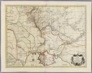
Full Title
Maris Caspii Littori occidentali inter Fluviorum Wolgae et Kur Ostia adiacentium Terrarum Provintiarum et Locorum eorumque Incolarum. Descriptio, Simul ac in Provincus Schirwan et Lesgistan inter Russos et Turcas Terrarum Divisionis Linea Anno 1727 determinata.
List No
5825.030
Note
Outline color map. Showing Caspian Sea between the western shore of the rivers Kur and the Volga, and adjoining provinces. Title in Russian. Text in Russian and German. Elaborate cartouche on lower left corner, with 4 figures representing different peoples of the Caucasus. Relief shown pictorially.
Author
[Akademiia nauk SSSR, L'Isle, Joseph Nicolas de, Academie der Wissenschafften, Academy of Sciences, St. Petersburg]
Full Title
Charte der Kriegs Operationen am Donn und Dnieper. Ihro Russisch Key Serl: Maiesty: Glorieusen Armeen Ao.1736. gestochen bey der Keyserl: Acad: der Wissensch: in St. Petersb.
List No
5825.031
Note
Outline color map of the southern part of Ukraine, with an explanatory key A-N in lower right. Showing Russian-Turkish war operations of 1736, with engravings of military fortifications. With engravings of military fortifications. Elaborate cartouche on upper right corner. Relief shown pictorially.
Author
[Akademiia nauk SSSR, L'Isle, Joseph Nicolas de, Academie der Wissenschafften, Academy of Sciences, St. Petersburg]
Full Title
Charte derer von der Russisch-Keyser Armee im Jahr 1736 zwisschen und an dem Dnieper und Donn wieder die Turcken und Tartarn siegreich unternommenen Kriegs-Operationen.
List No
5825.032
Note
Outline color map. Showing line of military operations between the Russian and Ottoman armies. With engravings of sailing ships and military fortifications. Elaborate title cartouche. Relief shown pictorially.
Author
[Akademiia nauk SSSR, L'Isle, Joseph Nicolas de, Academie der Wissenschafften, Academy of Sciences, St. Petersburg]
Full Title
Verus Chersonesi Tauricae Seu Crimeae Conspectus adjacentium item Regionem Itinerisq ab Exercitu Rutheno Ao MDCCXXXVI et MDCCXXXVII adversus Tattaros suscepti. Editus ex Autographis Carolia Frauendorff Centurionis in Acad: sc: Petropolit.
List No
5825.033
Note
Outline color map of Ukraine and Black Sea region, showing the route of the Russian Army in its expedition against the Tatars in 1736 and 1737. Includes sailing ships, and military fortifications. Elaborate title cartouche. Relief shown pictorially.
Author
[Akademiia nauk SSSR, L'Isle, Joseph Nicolas de, Academie der Wissenschafften, Academy of Sciences, St. Petersburg]
Full Title
(Text Page to) Explicatio Duarum Tabularum Geographicarum, Aere In Academia Petropolitana Incisarum Prima Est Inscripta: Theatrum Belli a Milite Augustae Ruthenorum (Russorum) Imperatricis Adversus Turcas et Tartaros ... Gesti. Verus Chersonesi Tauricae seu Crimae Conspectus, Adjacentium item Regionum, Itinerisque Ab Expercitu Rutheno Adversus Tartaros A. MDCCXXXVI. et VII. Susepti.
List No
5825.034
Note
Explanatory text for 2 maps made under the supervision of the Academy of Sciences: "Theatrum Belli a Milite..." that is Theater of war conducted by Imperial Russian Army against the Turkish Army and Tatars in 1737; and "Verus Chersoneri..." that is a true description of the Crimean Peninsula with surrounding training grounds in 1736 and 37, Russian Army against Tatar Marshals. Text is in Latin, Russian and German.
Author
[Akademiia nauk SSSR, L'Isle, Joseph Nicolas de, Academie der Wissenschafften, Academy of Sciences, St. Petersburg]
Full Title
Theatrum Belli Ao MDCCXXXVII. a milite Augustae Russorum Imperatricis adversus Turcas Tattarosque gesti. Ex. autographis in Acad: Scient: Petropol.
List No
5825.035
Note
Outline color map of Black Sea region, showing rivers, and canals. Includes military fortifications. Elaborate title cartouche. Relief shown pictorially.
Author
[Akademiia nauk SSSR, L'Isle, Joseph Nicolas de, Academie der Wissenschafften, Academy of Sciences, St. Petersburg]
Full Title
Theatrum Belli ad Borysthenem Tyram & Danubium Fluvios gesti Ao= MDCCXXVIII. Excus. in Academia Scientiarum Petropolitana.
List No
5825.036
Note
Detail outline color map of Black Sea region, showing name of places, rivers, and canals. Includes sailing ships, military routes and fortifications. Elaborate title cartouche. Relief shown pictorially.
Author
[Akademiia nauk SSSR, L'Isle, Joseph Nicolas de, Academie der Wissenschafften, Academy of Sciences, St. Petersburg]
Full Title
Plan Batalii pri Stavuchanakh v Moldavii = Plan der Bataille bey Stovutschane in der Moldau zwishen der Russisch-Kayserl.
List No
5825.037
Note
Detail color map, showing the plan of battle near Stavuchanakh in Moldavia, between the Imperial Russian Grand Army under the commander General Field Marshal von Münich and the Turkish and Tartar Armies under the command of Serasker Trekh Bunchuzhnago, led by Wely Pasha and Saltan Islam Girei in 17/28 August 1739. Includes, military position and routes, and military fortifications. Elaborate title cartouche. Title and key in Russian and German.
Author
[Akademiia nauk SSSR, L'Isle, Joseph Nicolas de, Academie der Wissenschafften, Academy of Sciences, St. Petersburg]
Full Title
Ladozhskoe ozero i Finskii zaliv s prilezhashchimi Mestami = Lacus Ladoga et Sinus Finnicus cum interiacentibus et adiacentibus Regionibus.
List No
5825.038
Note
Detail color map of Lake Ladoga and the Gulf of Finland with the Surrounding Area. Showing roads, administrative divisions, boundaries of provinces, monasteries, districts, military fortifications, rivers, agricultural lands, and, forests. Place names in Latin and Russian. Elaborate title cartouche. Title in Russian and Latin.
Author
[Akademiia nauk SSSR, L'Isle, Joseph Nicolas de, Academie der Wissenschafften, Academy of Sciences, St. Petersburg]
Full Title
Ladozhskoi Kanal - Canalis Ladogensis. (inset) Profil' kanala po linii AB = Orthographia Canalis delineatio secundum lineam AB". Scale [ca. 1:260],
List No
5825.039
Note
Detail color map of Lake Ladoga and Surrounding Area. Showing roads, rivers, settlements, and, forests. Place names in Latin and Russian. Elaborate title cartouche with figures and symbols of construction, engineering, farming and military attributes. Title in Russian and Latin. Inset of canal cross-section at a scale of 1:260.
Author
[Akademiia nauk SSSR, L'Isle, Joseph Nicolas de, Academie der Wissenschafften, Academy of Sciences, St. Petersburg]
Full Title
Ladozhskoe Ozero - Lacus Ladoga. Techenie Nevy reki iz Ladozhskago ozera k St. Peterburgu = Fluvius Newa e Lacu Ladoga Petropolin versus procurrens.
List No
5825.040
Note
Detail color map of Neva River from Lake Ladoga to St. Petersburg. Boundaries are colored. Showing Ladoga Canal and Surrounding Area, roads, rivers, waterways, settlements, monastery, vegetation, and, forests. Title cartouche with figures and images of coats of arms of St. Petersburg and the Russian Empire, the symbols of fishing, farming and military attributes.
Author
[Akademiia nauk SSSR, L'Isle, Joseph Nicolas de, Academie der Wissenschafften, Academy of Sciences, St. Petersburg]
Full Title
Finskoi zaliv ot Kronshtata do Sanktpeterburga s lezhashchimi po beregam zadatnymi domami = Der Sinus Finnicus von Cronstad bis St Petersburg benebst den auf seinen Kusten befindlichen Lufthofen.
List No
5825.041
Note
Detail color map of Neva River waterfront at St. Petersburg. Showing roads, rivers, waterways, settlements, vegetation, and, forests. Title cartouche with images of St. Petersburg waterfront. Shows sailing ships in the sea area. Title and key in Russian and German.
Author
[Akademiia nauk SSSR, L'Isle, Joseph Nicolas de, Academie der Wissenschafften, Academy of Sciences, St. Petersburg]
Full Title
Ingria et Carelia.
List No
5825.042
Note
Detail outline color map. Showing roads, rivers, waterways, administrative boundaries, monasteries, vegetation, and sailing ships. Title cartouche with statue of Peter the Great and a view of St.Petersburg. Title in Latin.
Author
[Akademiia nauk SSSR, L'Isle, Joseph Nicolas de, Academie der Wissenschafften, Academy of Sciences, St. Petersburg]
Full Title
Karta Ingermanlandii i karelii pechataia pri Imperatorskoi Akademii Nauk.
List No
5825.043
Note
Detail outline color map. Showing roads, rivers, monasteries, administrative boundaries, canals, forest and vegetations. Title cartouche with statue of Peter the Great and a view of St. Petersburg. Title and place names in Russian.
Author
[Akademiia nauk SSSR, L'Isle, Joseph Nicolas de, Academie der Wissenschafften, Academy of Sciences, St. Petersburg]
Full Title
Die Festung Willmanstrandt wo die Russ. Kays. Truppen unter Anfuhrung des General Field Marechals Gr. von Lacy uber ein Schwedisches... 23. Aug. 1741 einen Volkommenen Sieg Erhalten ... Ordere de Bataille. General Feld-Marshal Graf von Lacy, General Keith, General-Lieutenant von Stossel. General Majors Fermor, Albrecht, von Lieven...
List No
5825.044
Note
Detail color map. Showing battlefields and military fortifications. Title and key in German.
Author
[Akademiia nauk SSSR, L'Isle, Joseph Nicolas de, Academie der Wissenschafften, Academy of Sciences, St. Petersburg]
Full Title
Magnus Ducatus Finlandiae.
List No
5825.045
Note
Detail outline color map. Showing administrative divisions.Title in Latin. Place names in Russian and Latin.
1-47 of 47
|