|
Author
Arrowsmith, Aaron
Full Title
(Covers to) A New General Atlas, Constructed from the latest Authorities, By A. Arrowsmith, Hydrographer to the Prince Regent, Exhibiting The Boundaries And Divisions, Also The Chains of Mountains and other Geographical Features Of All The Known Countries In The World; Comprehended In Fifty Three Maps From Original Drawings. Edinburgh, Published, 1817 by A. Constable & Co. And By Longman & Compy., London. (title page only) Hy. Corbould delt. Chas. Heath sculpt. Sidy. Hall script. Bury Stt. Bloomsby.
List No
5960.001
Note
First edition of Arrowsmith atlas published in 1817. Although the maps are not large, they are dense with information. This complete atlas features index and 53 copperplate maps, drawn by Arrowsmith and engraved by Sidney Hall, with a few engraved by Thomson in collaboration with Hall. The maps include two world, 29 related to Europe and Scandinavia, 16 on Asia, Africa, and Oceania, and six related to the Americas. The United States map shows Georgia extending from the coast to the Mississippi River. The area west of the Mississippi is blank and labeled Louisiana. Engraved title page has Atlas holding the globe above two putti, one sailing a dingy, the other engaged in cartographic studies with a globe, map and dividers. Hardbound with marbled paper and original paper label printed with "Arrowsmith's New General Atlas Comprehended in Fifty three Maps From Original Drawings. Price L 2,12,6. coloured". Black leather spine has a label embossed with "Atlas (18)17" in gilt. Maps have original outline color, with many tissue guards still in place.
Author
Arrowsmith, Aaron
Full Title
(Title page to) A New General Atlas, Constructed from the latest Authorities, By A. Arrowsmith, Hydrographer to the Prince Regent, Exhibiting The Boundaries And Divisions, Also The Chains of Mountains and other Geographical Features Of All The Known Countries In The World; Comprehended In Fifty Three Maps From Original Drawings. Edinburgh, Published, 1817 by A. Constable & Co. And By Longman & Compy., London. (title page only) Hy. Corbould delt. Chas. Heath sculpt. Sidy. Hall script. Bury Stt. Bloomsby.
List No
5960.002
Note
First edition of Arrowsmith atlas published in 1817. Although the maps are not large, they are dense with information. This complete atlas features index and 53 copperplate maps, drawn by Arrowsmith and engraved by Sidney Hall, with a few engraved by Thomson in collaboration with Hall. The maps include two world, 29 related to Europe and Scandinavia, 16 on Asia, Africa, and Oceania, and six related to the Americas. The United States map shows Georgia extending from the coast to the Mississippi River. The area west of the Mississippi is blank and labeled Louisiana. Engraved title page has Atlas holding the globe above two putti, one sailing a dingy, the other engaged in cartographic studies with a globe, map and dividers. Hardbound with marbled paper and original paper label printed with "Arrowsmith's New General Atlas Comprehended in Fifty three Maps From Original Drawings. Price L 2,12,6. coloured". Black leather spine has a label embossed with "Atlas (18)17" in gilt. Maps have original outline color, with many tissue guards still in place.
Author
Arrowsmith, Aaron
Full Title
(Index page to) A New General Atlas, Constructed from the latest Authorities, By A. Arrowsmith, Hydrographer to the Prince Regent, Exhibiting The Boundaries And Divisions, Also The Chains of Mountains and other Geographical Features Of All The Known Countries In The World; Comprehended In Fifty Three Maps From Original Drawings. Edinburgh, Published, 1817 by A. Constable & Co. And By Longman & Compy., London. (title page only) Hy. Corbould delt. Chas. Heath sculpt. Sidy. Hall script. Bury Stt. Bloomsby.
List No
5960.003
Note
First edition of Arrowsmith atlas published in 1817. Although the maps are not large, they are dense with information. This complete atlas features index and 53 copperplate maps, drawn by Arrowsmith and engraved by Sidney Hall, with a few engraved by Thomson in collaboration with Hall. The maps include two world, 29 related to Europe and Scandinavia, 16 on Asia, Africa, and Oceania, and six related to the Americas. The United States map shows Georgia extending from the coast to the Mississippi River. The area west of the Mississippi is blank and labeled Louisiana. Engraved title page has Atlas holding the globe above two putti, one sailing a dingy, the other engaged in cartographic studies with a globe, map and dividers. Hardbound with marbled paper and original paper label printed with "Arrowsmith's New General Atlas Comprehended in Fifty three Maps From Original Drawings. Price L 2,12,6. coloured". Black leather spine has a label embossed with "Atlas (18)17" in gilt. Maps have original outline color, with many tissue guards still in place.
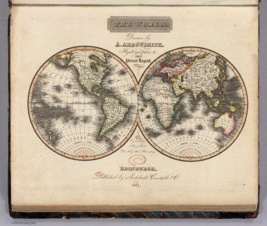
Author
Arrowsmith, Aaron
Full Title
The World. Drawn by A. Arrowsmith, Hydrographer to the Prince Regent. Engraved by Sidney Hall, No. 14 Bury Street, Bloomsby. Edinburgh, Published by Archibald. Constable & Co. 1817.
List No
5960.004
Note
First edition of Arrowsmith atlas published in 1817. Although the maps are not large, they are dense with information. This complete atlas features index and 53 copperplate maps, drawn by Arrowsmith and engraved by Sidney Hall, with a few engraved by Thomson in collaboration with Hall. The maps include two world, 29 related to Europe and Scandinavia, 16 on Asia, Africa, and Oceania, and six related to the Americas. The United States map shows Georgia extending from the coast to the Mississippi River. The area west of the Mississippi is blank and labeled Louisiana. Engraved title page has Atlas holding the globe above two putti, one sailing a dingy, the other engaged in cartographic studies with a globe, map and dividers. Hardbound with marbled paper and original paper label printed with "Arrowsmith's New General Atlas Comprehended in Fifty three Maps From Original Drawings. Price L 2,12,6. coloured". Black leather spine has a label embossed with "Atlas (18)17" in gilt. Maps have original outline color, with many tissue guards still in place.
Author
Arrowsmith, Aaron
Full Title
The World on Mercator's Projection. Drawn by A. Arrowsmith. Engraved by Sidy. Hall. Published, 1817, by A. Constable & Co. Edinburgh.
List No
5960.005
Note
First edition of Arrowsmith atlas published in 1817. Although the maps are not large, they are dense with information. This complete atlas features index and 53 copperplate maps, drawn by Arrowsmith and engraved by Sidney Hall, with a few engraved by Thomson in collaboration with Hall. The maps include two world, 29 related to Europe and Scandinavia, 16 on Asia, Africa, and Oceania, and six related to the Americas. The United States map shows Georgia extending from the coast to the Mississippi River. The area west of the Mississippi is blank and labeled Louisiana. Engraved title page has Atlas holding the globe above two putti, one sailing a dingy, the other engaged in cartographic studies with a globe, map and dividers. Hardbound with marbled paper and original paper label printed with "Arrowsmith's New General Atlas Comprehended in Fifty three Maps From Original Drawings. Price L 2,12,6. coloured". Black leather spine has a label embossed with "Atlas (18)17" in gilt. Maps have original outline color, with many tissue guards still in place.
Author
Arrowsmith, Aaron
Full Title
Europe. Drawn by A. Arrowsmith. Engraved by Sy. Hall, 14 Bury Stt. Bloomsby. Published, 1817, by A. Constable & Co. Edinburgh.
List No
5960.006
Note
First edition of Arrowsmith atlas published in 1817. Although the maps are not large, they are dense with information. This complete atlas features index and 53 copperplate maps, drawn by Arrowsmith and engraved by Sidney Hall, with a few engraved by Thomson in collaboration with Hall. The maps include two world, 29 related to Europe and Scandinavia, 16 on Asia, Africa, and Oceania, and six related to the Americas. The United States map shows Georgia extending from the coast to the Mississippi River. The area west of the Mississippi is blank and labeled Louisiana. Engraved title page has Atlas holding the globe above two putti, one sailing a dingy, the other engaged in cartographic studies with a globe, map and dividers. Hardbound with marbled paper and original paper label printed with "Arrowsmith's New General Atlas Comprehended in Fifty three Maps From Original Drawings. Price L 2,12,6. coloured". Black leather spine has a label embossed with "Atlas (18)17" in gilt. Maps have original outline color, with many tissue guards still in place.
Author
Arrowsmith, Aaron
Full Title
British Islands. Drawn by A. Arrowsmith. Engraved by Sy. Hal,. 14 Bury Stt. Bloomsby. Published, 1817, by A. Constable & Co. Edinburgh.
List No
5960.007
Note
First edition of Arrowsmith atlas published in 1817. Although the maps are not large, they are dense with information. This complete atlas features index and 53 copperplate maps, drawn by Arrowsmith and engraved by Sidney Hall, with a few engraved by Thomson in collaboration with Hall. The maps include two world, 29 related to Europe and Scandinavia, 16 on Asia, Africa, and Oceania, and six related to the Americas. The United States map shows Georgia extending from the coast to the Mississippi River. The area west of the Mississippi is blank and labeled Louisiana. Engraved title page has Atlas holding the globe above two putti, one sailing a dingy, the other engaged in cartographic studies with a globe, map and dividers. Hardbound with marbled paper and original paper label printed with "Arrowsmith's New General Atlas Comprehended in Fifty three Maps From Original Drawings. Price L 2,12,6. coloured". Black leather spine has a label embossed with "Atlas (18)17" in gilt. Maps have original outline color, with many tissue guards still in place.
Author
Arrowsmith, Aaron
Full Title
England. Drawn by A. Arrowsmith. Engraved by S. Hall, 14 Bury Stt. Bloomsby. Published, 1817, by Constable & Co. Edinburgh and Longman & Compy. London.
List No
5960.008
Note
First edition of Arrowsmith atlas published in 1817. Although the maps are not large, they are dense with information. This complete atlas features index and 53 copperplate maps, drawn by Arrowsmith and engraved by Sidney Hall, with a few engraved by Thomson in collaboration with Hall. The maps include two world, 29 related to Europe and Scandinavia, 16 on Asia, Africa, and Oceania, and six related to the Americas. The United States map shows Georgia extending from the coast to the Mississippi River. The area west of the Mississippi is blank and labeled Louisiana. Engraved title page has Atlas holding the globe above two putti, one sailing a dingy, the other engaged in cartographic studies with a globe, map and dividers. Hardbound with marbled paper and original paper label printed with "Arrowsmith's New General Atlas Comprehended in Fifty three Maps From Original Drawings. Price L 2,12,6. coloured". Black leather spine has a label embossed with "Atlas (18)17" in gilt. Maps have original outline color, with many tissue guards still in place.
Author
Arrowsmith, Aaron
Full Title
Scotland. Drawn by A. Arrowsmith. Engraved by Sy. Hall. 14 Bury Stt. Bloomsby. Published, 1817, by A. Constable & Co. Edinburgh.
List No
5960.009
Note
First edition of Arrowsmith atlas published in 1817. Although the maps are not large, they are dense with information. This complete atlas features index and 53 copperplate maps, drawn by Arrowsmith and engraved by Sidney Hall, with a few engraved by Thomson in collaboration with Hall. The maps include two world, 29 related to Europe and Scandinavia, 16 on Asia, Africa, and Oceania, and six related to the Americas. The United States map shows Georgia extending from the coast to the Mississippi River. The area west of the Mississippi is blank and labeled Louisiana. Engraved title page has Atlas holding the globe above two putti, one sailing a dingy, the other engaged in cartographic studies with a globe, map and dividers. Hardbound with marbled paper and original paper label printed with "Arrowsmith's New General Atlas Comprehended in Fifty three Maps From Original Drawings. Price L 2,12,6. coloured". Black leather spine has a label embossed with "Atlas (18)17" in gilt. Maps have original outline color, with many tissue guards still in place.
Author
Arrowsmith, Aaron
Full Title
Ireland. Drawn by A. Arrowsmith. Engraved by Sy. Hall,14 Bury Stt. Bloomsby. Published, 1817, by A. Constable & Co. Edinburgh.
List No
5960.010
Note
First edition of Arrowsmith atlas published in 1817. Although the maps are not large, they are dense with information. This complete atlas features index and 53 copperplate maps, drawn by Arrowsmith and engraved by Sidney Hall, with a few engraved by Thomson in collaboration with Hall. The maps include two world, 29 related to Europe and Scandinavia, 16 on Asia, Africa, and Oceania, and six related to the Americas. The United States map shows Georgia extending from the coast to the Mississippi River. The area west of the Mississippi is blank and labeled Louisiana. Engraved title page has Atlas holding the globe above two putti, one sailing a dingy, the other engaged in cartographic studies with a globe, map and dividers. Hardbound with marbled paper and original paper label printed with "Arrowsmith's New General Atlas Comprehended in Fifty three Maps From Original Drawings. Price L 2,12,6. coloured". Black leather spine has a label embossed with "Atlas (18)17" in gilt. Maps have original outline color, with many tissue guards still in place.
Author
Arrowsmith, Aaron
Full Title
Orkney and Shetland Islands. Drawn by A. Arrowsmith. Engraved by Sidy. Hall. Published, 1817, by A. Constable & Co. Edinburgh. (inset maps) Jersey, Guernsey, &c. and Scilly Islands.
List No
5960.011
Note
First edition of Arrowsmith atlas published in 1817. Although the maps are not large, they are dense with information. This complete atlas features index and 53 copperplate maps, drawn by Arrowsmith and engraved by Sidney Hall, with a few engraved by Thomson in collaboration with Hall. The maps include two world, 29 related to Europe and Scandinavia, 16 on Asia, Africa, and Oceania, and six related to the Americas. The United States map shows Georgia extending from the coast to the Mississippi River. The area west of the Mississippi is blank and labeled Louisiana. Engraved title page has Atlas holding the globe above two putti, one sailing a dingy, the other engaged in cartographic studies with a globe, map and dividers. Hardbound with marbled paper and original paper label printed with "Arrowsmith's New General Atlas Comprehended in Fifty three Maps From Original Drawings. Price L 2,12,6. coloured". Black leather spine has a label embossed with "Atlas (18)17" in gilt. Maps have original outline color, with many tissue guards still in place.
Author
Arrowsmith, Aaron
Full Title
France, N.W. Part. Drawn by A. Arrowsmith. Engraved by Sidy. Hall. Published, 1817, by A. Constable & Co. Edinburgh.
List No
5960.012
Note
First edition of Arrowsmith atlas published in 1817. Although the maps are not large, they are dense with information. This complete atlas features index and 53 copperplate maps, drawn by Arrowsmith and engraved by Sidney Hall, with a few engraved by Thomson in collaboration with Hall. The maps include two world, 29 related to Europe and Scandinavia, 16 on Asia, Africa, and Oceania, and six related to the Americas. The United States map shows Georgia extending from the coast to the Mississippi River. The area west of the Mississippi is blank and labeled Louisiana. Engraved title page has Atlas holding the globe above two putti, one sailing a dingy, the other engaged in cartographic studies with a globe, map and dividers. Hardbound with marbled paper and original paper label printed with "Arrowsmith's New General Atlas Comprehended in Fifty three Maps From Original Drawings. Price L 2,12,6. coloured". Black leather spine has a label embossed with "Atlas (18)17" in gilt. Maps have original outline color, with many tissue guards still in place.
Author
Arrowsmith, Aaron
Full Title
France, N.E. Part. Drawn by A. Arrowsmith. Engraved by Sidy. Hall. Published, 1817, by A. Constable & Co. Edinburgh.
List No
5960.013
Note
First edition of Arrowsmith atlas published in 1817. Although the maps are not large, they are dense with information. This complete atlas features index and 53 copperplate maps, drawn by Arrowsmith and engraved by Sidney Hall, with a few engraved by Thomson in collaboration with Hall. The maps include two world, 29 related to Europe and Scandinavia, 16 on Asia, Africa, and Oceania, and six related to the Americas. The United States map shows Georgia extending from the coast to the Mississippi River. The area west of the Mississippi is blank and labeled Louisiana. Engraved title page has Atlas holding the globe above two putti, one sailing a dingy, the other engaged in cartographic studies with a globe, map and dividers. Hardbound with marbled paper and original paper label printed with "Arrowsmith's New General Atlas Comprehended in Fifty three Maps From Original Drawings. Price L 2,12,6. coloured". Black leather spine has a label embossed with "Atlas (18)17" in gilt. Maps have original outline color, with many tissue guards still in place.
Author
Arrowsmith, Aaron
Full Title
France, S.W. Part. Drawn by A. Arrowsmith. Engraved by Sidy. Hall, 14 Bury Stt. Bloomsby. Published, 1817, by A. Constable & Co. Edinburgh.
List No
5960.014
Note
First edition of Arrowsmith atlas published in 1817. Although the maps are not large, they are dense with information. This complete atlas features index and 53 copperplate maps, drawn by Arrowsmith and engraved by Sidney Hall, with a few engraved by Thomson in collaboration with Hall. The maps include two world, 29 related to Europe and Scandinavia, 16 on Asia, Africa, and Oceania, and six related to the Americas. The United States map shows Georgia extending from the coast to the Mississippi River. The area west of the Mississippi is blank and labeled Louisiana. Engraved title page has Atlas holding the globe above two putti, one sailing a dingy, the other engaged in cartographic studies with a globe, map and dividers. Hardbound with marbled paper and original paper label printed with "Arrowsmith's New General Atlas Comprehended in Fifty three Maps From Original Drawings. Price L 2,12,6. coloured". Black leather spine has a label embossed with "Atlas (18)17" in gilt. Maps have original outline color, with many tissue guards still in place.
Author
Arrowsmith, Aaron
Full Title
France, S.E. Part. Drawn by A. Arrowsmith. Engraved by Sidy. Hall, 14 Bury Stt. Bloomsby. Published, 1817, by A. Constable & Co. Edinburgh.
List No
5960.015
Note
First edition of Arrowsmith atlas published in 1817. Although the maps are not large, they are dense with information. This complete atlas features index and 53 copperplate maps, drawn by Arrowsmith and engraved by Sidney Hall, with a few engraved by Thomson in collaboration with Hall. The maps include two world, 29 related to Europe and Scandinavia, 16 on Asia, Africa, and Oceania, and six related to the Americas. The United States map shows Georgia extending from the coast to the Mississippi River. The area west of the Mississippi is blank and labeled Louisiana. Engraved title page has Atlas holding the globe above two putti, one sailing a dingy, the other engaged in cartographic studies with a globe, map and dividers. Hardbound with marbled paper and original paper label printed with "Arrowsmith's New General Atlas Comprehended in Fifty three Maps From Original Drawings. Price L 2,12,6. coloured". Black leather spine has a label embossed with "Atlas (18)17" in gilt. Maps have original outline color, with many tissue guards still in place.
Author
Arrowsmith, Aaron
Full Title
(Composite of) France
List No
5960.057
Note
Composite of the four sheet maps of France.
Author
Arrowsmith, Aaron
Full Title
Germany, N.W. Part. Drawn by A. Arrowsmith. Engraved by Sy. Hall, 14 Bury Stt. Bloomsby. Published, 1817, by A. Constable & Co. Edinburgh.
List No
5960.016
Note
First edition of Arrowsmith atlas published in 1817. Although the maps are not large, they are dense with information. This complete atlas features index and 53 copperplate maps, drawn by Arrowsmith and engraved by Sidney Hall, with a few engraved by Thomson in collaboration with Hall. The maps include two world, 29 related to Europe and Scandinavia, 16 on Asia, Africa, and Oceania, and six related to the Americas. The United States map shows Georgia extending from the coast to the Mississippi River. The area west of the Mississippi is blank and labeled Louisiana. Engraved title page has Atlas holding the globe above two putti, one sailing a dingy, the other engaged in cartographic studies with a globe, map and dividers. Hardbound with marbled paper and original paper label printed with "Arrowsmith's New General Atlas Comprehended in Fifty three Maps From Original Drawings. Price L 2,12,6. coloured". Black leather spine has a label embossed with "Atlas (18)17" in gilt. Maps have original outline color, with many tissue guards still in place.
Author
Arrowsmith, Aaron
Full Title
Germany, N.E. Part. Drawn by A. Arrowsmith. Engraved by Sy. Hall, 14 Bury Stt. Bloomsby. Published, 1817, by A. Constable & Co. Edinburgh.
List No
5960.017
Note
First edition of Arrowsmith atlas published in 1817. Although the maps are not large, they are dense with information. This complete atlas features index and 53 copperplate maps, drawn by Arrowsmith and engraved by Sidney Hall, with a few engraved by Thomson in collaboration with Hall. The maps include two world, 29 related to Europe and Scandinavia, 16 on Asia, Africa, and Oceania, and six related to the Americas. The United States map shows Georgia extending from the coast to the Mississippi River. The area west of the Mississippi is blank and labeled Louisiana. Engraved title page has Atlas holding the globe above two putti, one sailing a dingy, the other engaged in cartographic studies with a globe, map and dividers. Hardbound with marbled paper and original paper label printed with "Arrowsmith's New General Atlas Comprehended in Fifty three Maps From Original Drawings. Price L 2,12,6. coloured". Black leather spine has a label embossed with "Atlas (18)17" in gilt. Maps have original outline color, with many tissue guards still in place.
Author
Arrowsmith, Aaron
Full Title
Germany, S.W. Part. Drawn by A. Arrowsmith. Engraved by Sy. Hall, 14 Burry Stt. Bloomsby. Published, 1817, by A. Constable & Co. Edinburgh.
List No
5960.018
Note
First edition of Arrowsmith atlas published in 1817. Although the maps are not large, they are dense with information. This complete atlas features index and 53 copperplate maps, drawn by Arrowsmith and engraved by Sidney Hall, with a few engraved by Thomson in collaboration with Hall. The maps include two world, 29 related to Europe and Scandinavia, 16 on Asia, Africa, and Oceania, and six related to the Americas. The United States map shows Georgia extending from the coast to the Mississippi River. The area west of the Mississippi is blank and labeled Louisiana. Engraved title page has Atlas holding the globe above two putti, one sailing a dingy, the other engaged in cartographic studies with a globe, map and dividers. Hardbound with marbled paper and original paper label printed with "Arrowsmith's New General Atlas Comprehended in Fifty three Maps From Original Drawings. Price L 2,12,6. coloured". Black leather spine has a label embossed with "Atlas (18)17" in gilt. Maps have original outline color, with many tissue guards still in place.
Author
Arrowsmith, Aaron
Full Title
Germany, S.E. Part. Drawn by A. Arrowsmith. Engraved by Sy. Hall. 14 Bury Stt. Bloomsby. Published, 1817, by A. Constable & Co. Edinburgh.
List No
5960.019
Note
First edition of Arrowsmith atlas published in 1817. Although the maps are not large, they are dense with information. This complete atlas features index and 53 copperplate maps, drawn by Arrowsmith and engraved by Sidney Hall, with a few engraved by Thomson in collaboration with Hall. The maps include two world, 29 related to Europe and Scandinavia, 16 on Asia, Africa, and Oceania, and six related to the Americas. The United States map shows Georgia extending from the coast to the Mississippi River. The area west of the Mississippi is blank and labeled Louisiana. Engraved title page has Atlas holding the globe above two putti, one sailing a dingy, the other engaged in cartographic studies with a globe, map and dividers. Hardbound with marbled paper and original paper label printed with "Arrowsmith's New General Atlas Comprehended in Fifty three Maps From Original Drawings. Price L 2,12,6. coloured". Black leather spine has a label embossed with "Atlas (18)17" in gilt. Maps have original outline color, with many tissue guards still in place.
Author
Arrowsmith, Aaron
Full Title
(Composite of) Germany
List No
5960.058
Note
A composite of the four sheet maps of Germany
Author
Arrowsmith, Aaron
Full Title
Italy, North Part. Drawn by A. Arrowsmith. Engraved by Sidy. Hall, 14 Bury Stt. Bloomsby. Published, 1817, by A. Constable & Co. Edinburgh.
List No
5960.020
Note
First edition of Arrowsmith atlas published in 1817. Although the maps are not large, they are dense with information. This complete atlas features index and 53 copperplate maps, drawn by Arrowsmith and engraved by Sidney Hall, with a few engraved by Thomson in collaboration with Hall. The maps include two world, 29 related to Europe and Scandinavia, 16 on Asia, Africa, and Oceania, and six related to the Americas. The United States map shows Georgia extending from the coast to the Mississippi River. The area west of the Mississippi is blank and labeled Louisiana. Engraved title page has Atlas holding the globe above two putti, one sailing a dingy, the other engaged in cartographic studies with a globe, map and dividers. Hardbound with marbled paper and original paper label printed with "Arrowsmith's New General Atlas Comprehended in Fifty three Maps From Original Drawings. Price L 2,12,6. coloured". Black leather spine has a label embossed with "Atlas (18)17" in gilt. Maps have original outline color, with many tissue guards still in place.
Author
Arrowsmith, Aaron
Full Title
Italy, South Part. Drawn by A. Arrowsmith. Engraved by Sy. Hall. 14 Bury Stt. Bloomsby. Published, 1817, by A. Constable & Co. Edinburgh.
List No
5960.021
Note
First edition of Arrowsmith atlas published in 1817. Although the maps are not large, they are dense with information. This complete atlas features index and 53 copperplate maps, drawn by Arrowsmith and engraved by Sidney Hall, with a few engraved by Thomson in collaboration with Hall. The maps include two world, 29 related to Europe and Scandinavia, 16 on Asia, Africa, and Oceania, and six related to the Americas. The United States map shows Georgia extending from the coast to the Mississippi River. The area west of the Mississippi is blank and labeled Louisiana. Engraved title page has Atlas holding the globe above two putti, one sailing a dingy, the other engaged in cartographic studies with a globe, map and dividers. Hardbound with marbled paper and original paper label printed with "Arrowsmith's New General Atlas Comprehended in Fifty three Maps From Original Drawings. Price L 2,12,6. coloured". Black leather spine has a label embossed with "Atlas (18)17" in gilt. Maps have original outline color, with many tissue guards still in place.
Author
Arrowsmith, Aaron
Full Title
(Composite of) Italy
List No
5960.059
Note
Composite of the two sheet maps of Italy.
Author
Arrowsmith, Aaron
Full Title
Russia in Europe. North Part. Drawn by A. Arrowsmith. Engraved by Sidy. Hall. Published, 1817, by A. Constable & Co. Edinburgh.
List No
5960.022
Note
First edition of Arrowsmith atlas published in 1817. Although the maps are not large, they are dense with information. This complete atlas features index and 53 copperplate maps, drawn by Arrowsmith and engraved by Sidney Hall, with a few engraved by Thomson in collaboration with Hall. The maps include two world, 29 related to Europe and Scandinavia, 16 on Asia, Africa, and Oceania, and six related to the Americas. The United States map shows Georgia extending from the coast to the Mississippi River. The area west of the Mississippi is blank and labeled Louisiana. Engraved title page has Atlas holding the globe above two putti, one sailing a dingy, the other engaged in cartographic studies with a globe, map and dividers. Hardbound with marbled paper and original paper label printed with "Arrowsmith's New General Atlas Comprehended in Fifty three Maps From Original Drawings. Price L 2,12,6. coloured". Black leather spine has a label embossed with "Atlas (18)17" in gilt. Maps have original outline color, with many tissue guards still in place.
Author
Arrowsmith, Aaron
Full Title
Russia in Europe. South Part. Drawn by A. Arrowsmith. Engraved by Sidy. Hall. Published, 1817, by A. Constable & Co. Edinburgh and Longman & Compy. London.
List No
5960.023
Note
First edition of Arrowsmith atlas published in 1817. Although the maps are not large, they are dense with information. This complete atlas features index and 53 copperplate maps, drawn by Arrowsmith and engraved by Sidney Hall, with a few engraved by Thomson in collaboration with Hall. The maps include two world, 29 related to Europe and Scandinavia, 16 on Asia, Africa, and Oceania, and six related to the Americas. The United States map shows Georgia extending from the coast to the Mississippi River. The area west of the Mississippi is blank and labeled Louisiana. Engraved title page has Atlas holding the globe above two putti, one sailing a dingy, the other engaged in cartographic studies with a globe, map and dividers. Hardbound with marbled paper and original paper label printed with "Arrowsmith's New General Atlas Comprehended in Fifty three Maps From Original Drawings. Price L 2,12,6. coloured". Black leather spine has a label embossed with "Atlas (18)17" in gilt. Maps have original outline color, with many tissue guards still in place.
Author
Arrowsmith, Aaron
Full Title
(Composite of) Russia in Europe
List No
5960.060
Note
Composite of the two sheets maps of Italy.
Author
Arrowsmith, Aaron
Full Title
Denmark, Sweden and Norway. Drawn by A. Arrowsmith. Engraved by Sy. Hall, 14 Bury Stt. Bloomsby. Published, 1817, by A. Constable & Co. Edinburgh.
List No
5960.024
Note
First edition of Arrowsmith atlas published in 1817. Although the maps are not large, they are dense with information. This complete atlas features index and 53 copperplate maps, drawn by Arrowsmith and engraved by Sidney Hall, with a few engraved by Thomson in collaboration with Hall. The maps include two world, 29 related to Europe and Scandinavia, 16 on Asia, Africa, and Oceania, and six related to the Americas. The United States map shows Georgia extending from the coast to the Mississippi River. The area west of the Mississippi is blank and labeled Louisiana. Engraved title page has Atlas holding the globe above two putti, one sailing a dingy, the other engaged in cartographic studies with a globe, map and dividers. Hardbound with marbled paper and original paper label printed with "Arrowsmith's New General Atlas Comprehended in Fifty three Maps From Original Drawings. Price L 2,12,6. coloured". Black leather spine has a label embossed with "Atlas (18)17" in gilt. Maps have original outline color, with many tissue guards still in place.
Author
Arrowsmith, Aaron
Full Title
Denmark. Drawn by A. Arrowsmith. Engraved by Sidy. Hall. Published, 1817, by A. Constable & Co. Edinburgh.
List No
5960.025
Note
First edition of Arrowsmith atlas published in 1817. Although the maps are not large, they are dense with information. This complete atlas features index and 53 copperplate maps, drawn by Arrowsmith and engraved by Sidney Hall, with a few engraved by Thomson in collaboration with Hall. The maps include two world, 29 related to Europe and Scandinavia, 16 on Asia, Africa, and Oceania, and six related to the Americas. The United States map shows Georgia extending from the coast to the Mississippi River. The area west of the Mississippi is blank and labeled Louisiana. Engraved title page has Atlas holding the globe above two putti, one sailing a dingy, the other engaged in cartographic studies with a globe, map and dividers. Hardbound with marbled paper and original paper label printed with "Arrowsmith's New General Atlas Comprehended in Fifty three Maps From Original Drawings. Price L 2,12,6. coloured". Black leather spine has a label embossed with "Atlas (18)17" in gilt. Maps have original outline color, with many tissue guards still in place.
Author
Arrowsmith, Aaron
Full Title
Spain and Portugal. Drawn by A. Arrowsmith. Engraved by Sidy. Hall. Published, 1817, by A. Constable & Co. Edinburgh.
List No
5960.026
Note
First edition of Arrowsmith atlas published in 1817. Although the maps are not large, they are dense with information. This complete atlas features index and 53 copperplate maps, drawn by Arrowsmith and engraved by Sidney Hall, with a few engraved by Thomson in collaboration with Hall. The maps include two world, 29 related to Europe and Scandinavia, 16 on Asia, Africa, and Oceania, and six related to the Americas. The United States map shows Georgia extending from the coast to the Mississippi River. The area west of the Mississippi is blank and labeled Louisiana. Engraved title page has Atlas holding the globe above two putti, one sailing a dingy, the other engaged in cartographic studies with a globe, map and dividers. Hardbound with marbled paper and original paper label printed with "Arrowsmith's New General Atlas Comprehended in Fifty three Maps From Original Drawings. Price L 2,12,6. coloured". Black leather spine has a label embossed with "Atlas (18)17" in gilt. Maps have original outline color, with many tissue guards still in place.
Author
Arrowsmith, Aaron
Full Title
Holland. Drawn by A. Arrowsmith. Engraved by Sidy. Hall. Published, 1817, by A. Constable & Co. Edinburgh.
List No
5960.027
Note
First edition of Arrowsmith atlas published in 1817. Although the maps are not large, they are dense with information. This complete atlas features index and 53 copperplate maps, drawn by Arrowsmith and engraved by Sidney Hall, with a few engraved by Thomson in collaboration with Hall. The maps include two world, 29 related to Europe and Scandinavia, 16 on Asia, Africa, and Oceania, and six related to the Americas. The United States map shows Georgia extending from the coast to the Mississippi River. The area west of the Mississippi is blank and labeled Louisiana. Engraved title page has Atlas holding the globe above two putti, one sailing a dingy, the other engaged in cartographic studies with a globe, map and dividers. Hardbound with marbled paper and original paper label printed with "Arrowsmith's New General Atlas Comprehended in Fifty three Maps From Original Drawings. Price L 2,12,6. coloured". Black leather spine has a label embossed with "Atlas (18)17" in gilt. Maps have original outline color, with many tissue guards still in place.
Author
Arrowsmith, Aaron
Full Title
Netherlands. Drawn by A. Arrowsmith. Engraved by Sy. Hall. Published, 1817, by A. Constable & Co. Edinburgh, and Longman & Compy. London.
List No
5960.028
Note
First edition of Arrowsmith atlas published in 1817. Although the maps are not large, they are dense with information. This complete atlas features index and 53 copperplate maps, drawn by Arrowsmith and engraved by Sidney Hall, with a few engraved by Thomson in collaboration with Hall. The maps include two world, 29 related to Europe and Scandinavia, 16 on Asia, Africa, and Oceania, and six related to the Americas. The United States map shows Georgia extending from the coast to the Mississippi River. The area west of the Mississippi is blank and labeled Louisiana. Engraved title page has Atlas holding the globe above two putti, one sailing a dingy, the other engaged in cartographic studies with a globe, map and dividers. Hardbound with marbled paper and original paper label printed with "Arrowsmith's New General Atlas Comprehended in Fifty three Maps From Original Drawings. Price L 2,12,6. coloured". Black leather spine has a label embossed with "Atlas (18)17" in gilt. Maps have original outline color, with many tissue guards still in place.
Author
Arrowsmith, Aaron
Full Title
Prussia. Drawn by A. Arrowsmith. Engraved by Sidy. Hall. Published, 1817, by A. Constable & Co. Edinburgh.
List No
5960.029
Note
First edition of Arrowsmith atlas published in 1817. Although the maps are not large, they are dense with information. This complete atlas features index and 53 copperplate maps, drawn by Arrowsmith and engraved by Sidney Hall, with a few engraved by Thomson in collaboration with Hall. The maps include two world, 29 related to Europe and Scandinavia, 16 on Asia, Africa, and Oceania, and six related to the Americas. The United States map shows Georgia extending from the coast to the Mississippi River. The area west of the Mississippi is blank and labeled Louisiana. Engraved title page has Atlas holding the globe above two putti, one sailing a dingy, the other engaged in cartographic studies with a globe, map and dividers. Hardbound with marbled paper and original paper label printed with "Arrowsmith's New General Atlas Comprehended in Fifty three Maps From Original Drawings. Price L 2,12,6. coloured". Black leather spine has a label embossed with "Atlas (18)17" in gilt. Maps have original outline color, with many tissue guards still in place.
Author
Arrowsmith, Aaron
Full Title
Switzerland. Drawn by A. Arrowsmith. Engraved by Sy. Hall, 14 Bury Stt. Bloomsby. Published, 1817, by A. Constable & Co. Edinburgh.
List No
5960.030
Note
First edition of Arrowsmith atlas published in 1817. Although the maps are not large, they are dense with information. This complete atlas features index and 53 copperplate maps, drawn by Arrowsmith and engraved by Sidney Hall, with a few engraved by Thomson in collaboration with Hall. The maps include two world, 29 related to Europe and Scandinavia, 16 on Asia, Africa, and Oceania, and six related to the Americas. The United States map shows Georgia extending from the coast to the Mississippi River. The area west of the Mississippi is blank and labeled Louisiana. Engraved title page has Atlas holding the globe above two putti, one sailing a dingy, the other engaged in cartographic studies with a globe, map and dividers. Hardbound with marbled paper and original paper label printed with "Arrowsmith's New General Atlas Comprehended in Fifty three Maps From Original Drawings. Price L 2,12,6. coloured". Black leather spine has a label embossed with "Atlas (18)17" in gilt. Maps have original outline color, with many tissue guards still in place.
Author
Arrowsmith, Aaron
Full Title
Portugal. Drawn by A. Arrowsmith. Engraved by Sidy. Hall. Published, 1817, by A. Constable & Co. Edinburgh.
List No
5960.031
Note
First edition of Arrowsmith atlas published in 1817. Although the maps are not large, they are dense with information. This complete atlas features index and 53 copperplate maps, drawn by Arrowsmith and engraved by Sidney Hall, with a few engraved by Thomson in collaboration with Hall. The maps include two world, 29 related to Europe and Scandinavia, 16 on Asia, Africa, and Oceania, and six related to the Americas. The United States map shows Georgia extending from the coast to the Mississippi River. The area west of the Mississippi is blank and labeled Louisiana. Engraved title page has Atlas holding the globe above two putti, one sailing a dingy, the other engaged in cartographic studies with a globe, map and dividers. Hardbound with marbled paper and original paper label printed with "Arrowsmith's New General Atlas Comprehended in Fifty three Maps From Original Drawings. Price L 2,12,6. coloured". Black leather spine has a label embossed with "Atlas (18)17" in gilt. Maps have original outline color, with many tissue guards still in place.
Author
Arrowsmith, Aaron
Full Title
Hungary. Drawn by A. Arrowsmith. Engraved by Sidy. Hall. Published, 1817, by A. Constable & Co. Edinburgh and longman & Compy. London.
List No
5960.032
Note
First edition of Arrowsmith atlas published in 1817. Although the maps are not large, they are dense with information. This complete atlas features index and 53 copperplate maps, drawn by Arrowsmith and engraved by Sidney Hall, with a few engraved by Thomson in collaboration with Hall. The maps include two world, 29 related to Europe and Scandinavia, 16 on Asia, Africa, and Oceania, and six related to the Americas. The United States map shows Georgia extending from the coast to the Mississippi River. The area west of the Mississippi is blank and labeled Louisiana. Engraved title page has Atlas holding the globe above two putti, one sailing a dingy, the other engaged in cartographic studies with a globe, map and dividers. Hardbound with marbled paper and original paper label printed with "Arrowsmith's New General Atlas Comprehended in Fifty three Maps From Original Drawings. Price L 2,12,6. coloured". Black leather spine has a label embossed with "Atlas (18)17" in gilt. Maps have original outline color, with many tissue guards still in place.
Author
Arrowsmith, Aaron
Full Title
Turkey in Europe. Drawn by A. Arrowsmith. Engraved by Sy. Hall. 14 Bury Stt. Bloomsby. Published, 1817, by A. Constable & Co. Edinburgh.
List No
5960.033
Note
First edition of Arrowsmith atlas published in 1817. Although the maps are not large, they are dense with information. This complete atlas features index and 53 copperplate maps, drawn by Arrowsmith and engraved by Sidney Hall, with a few engraved by Thomson in collaboration with Hall. The maps include two world, 29 related to Europe and Scandinavia, 16 on Asia, Africa, and Oceania, and six related to the Americas. The United States map shows Georgia extending from the coast to the Mississippi River. The area west of the Mississippi is blank and labeled Louisiana. Engraved title page has Atlas holding the globe above two putti, one sailing a dingy, the other engaged in cartographic studies with a globe, map and dividers. Hardbound with marbled paper and original paper label printed with "Arrowsmith's New General Atlas Comprehended in Fifty three Maps From Original Drawings. Price L 2,12,6. coloured". Black leather spine has a label embossed with "Atlas (18)17" in gilt. Maps have original outline color, with many tissue guards still in place.
Author
Arrowsmith, Aaron
Full Title
Greece. Drawn by A. Arrowsmith. Engraved by Sy. Hall. 14 Bury Stt. Bloomsby. Published, 1817, by A. Constable & Co. Edinburgh.
List No
5960.034
Note
First edition of Arrowsmith atlas published in 1817. Although the maps are not large, they are dense with information. This complete atlas features index and 53 copperplate maps, drawn by Arrowsmith and engraved by Sidney Hall, with a few engraved by Thomson in collaboration with Hall. The maps include two world, 29 related to Europe and Scandinavia, 16 on Asia, Africa, and Oceania, and six related to the Americas. The United States map shows Georgia extending from the coast to the Mississippi River. The area west of the Mississippi is blank and labeled Louisiana. Engraved title page has Atlas holding the globe above two putti, one sailing a dingy, the other engaged in cartographic studies with a globe, map and dividers. Hardbound with marbled paper and original paper label printed with "Arrowsmith's New General Atlas Comprehended in Fifty three Maps From Original Drawings. Price L 2,12,6. coloured". Black leather spine has a label embossed with "Atlas (18)17" in gilt. Maps have original outline color, with many tissue guards still in place.
Author
Arrowsmith, Aaron
Full Title
Asia. Drawn by A. Arrowsmith. Engraved by Sy. Hall. 14 Bury Stt. Bloomsby. Published, 1817, by A. Constable & Co. Edinburgh.
List No
5960.035
Note
First edition of Arrowsmith atlas published in 1817. Although the maps are not large, they are dense with information. This complete atlas features index and 53 copperplate maps, drawn by Arrowsmith and engraved by Sidney Hall, with a few engraved by Thomson in collaboration with Hall. The maps include two world, 29 related to Europe and Scandinavia, 16 on Asia, Africa, and Oceania, and six related to the Americas. The United States map shows Georgia extending from the coast to the Mississippi River. The area west of the Mississippi is blank and labeled Louisiana. Engraved title page has Atlas holding the globe above two putti, one sailing a dingy, the other engaged in cartographic studies with a globe, map and dividers. Hardbound with marbled paper and original paper label printed with "Arrowsmith's New General Atlas Comprehended in Fifty three Maps From Original Drawings. Price L 2,12,6. coloured". Black leather spine has a label embossed with "Atlas (18)17" in gilt. Maps have original outline color, with many tissue guards still in place.
Author
Arrowsmith, Aaron
Full Title
Hindoostan. Drawn by A. Arrowsmith. Engraved by Sy. Hall. 14 Bury Stt. Bloomsby. Published, 1817, by A. Constable & Co. Edinburgh and Longman & Compy., London.
List No
5960.036
Note
First edition of Arrowsmith atlas published in 1817. Although the maps are not large, they are dense with information. This complete atlas features index and 53 copperplate maps, drawn by Arrowsmith and engraved by Sidney Hall, with a few engraved by Thomson in collaboration with Hall. The maps include two world, 29 related to Europe and Scandinavia, 16 on Asia, Africa, and Oceania, and six related to the Americas. The United States map shows Georgia extending from the coast to the Mississippi River. The area west of the Mississippi is blank and labeled Louisiana. Engraved title page has Atlas holding the globe above two putti, one sailing a dingy, the other engaged in cartographic studies with a globe, map and dividers. Hardbound with marbled paper and original paper label printed with "Arrowsmith's New General Atlas Comprehended in Fifty three Maps From Original Drawings. Price L 2,12,6. coloured". Black leather spine has a label embossed with "Atlas (18)17" in gilt. Maps have original outline color, with many tissue guards still in place.
Author
Arrowsmith, Aaron
Full Title
Persia. Drawn by A. Arrowsmith. Engraved by Sidy. Hall. Published, 1817, by A. Constable & Co. Edinburgh and Longman & Compy., London.
List No
5960.037
Note
First edition of Arrowsmith atlas published in 1817. Although the maps are not large, they are dense with information. This complete atlas features index and 53 copperplate maps, drawn by Arrowsmith and engraved by Sidney Hall, with a few engraved by Thomson in collaboration with Hall. The maps include two world, 29 related to Europe and Scandinavia, 16 on Asia, Africa, and Oceania, and six related to the Americas. The United States map shows Georgia extending from the coast to the Mississippi River. The area west of the Mississippi is blank and labeled Louisiana. Engraved title page has Atlas holding the globe above two putti, one sailing a dingy, the other engaged in cartographic studies with a globe, map and dividers. Hardbound with marbled paper and original paper label printed with "Arrowsmith's New General Atlas Comprehended in Fifty three Maps From Original Drawings. Price L 2,12,6. coloured". Black leather spine has a label embossed with "Atlas (18)17" in gilt. Maps have original outline color, with many tissue guards still in place.
Author
Arrowsmith, Aaron
Full Title
China. Drawn by A. Arrowsmith. Engraved by Sidy. Hall. Published, 1817, by A. Constable & Co. Edinburgh.
List No
5960.038
Note
First edition of Arrowsmith atlas published in 1817. Although the maps are not large, they are dense with information. This complete atlas features index and 53 copperplate maps, drawn by Arrowsmith and engraved by Sidney Hall, with a few engraved by Thomson in collaboration with Hall. The maps include two world, 29 related to Europe and Scandinavia, 16 on Asia, Africa, and Oceania, and six related to the Americas. The United States map shows Georgia extending from the coast to the Mississippi River. The area west of the Mississippi is blank and labeled Louisiana. Engraved title page has Atlas holding the globe above two putti, one sailing a dingy, the other engaged in cartographic studies with a globe, map and dividers. Hardbound with marbled paper and original paper label printed with "Arrowsmith's New General Atlas Comprehended in Fifty three Maps From Original Drawings. Price L 2,12,6. coloured". Black leather spine has a label embossed with "Atlas (18)17" in gilt. Maps have original outline color, with many tissue guards still in place.
Author
Arrowsmith, Aaron
Full Title
Russia in Asia. Drawn by A. Arrowsmith. Engraved by Sidy. Hall. Published, 1817, by A. Constable & Co. Edinburgh and Longman & Compy. London.
List No
5960.039
Note
First edition of Arrowsmith atlas published in 1817. Although the maps are not large, they are dense with information. This complete atlas features index and 53 copperplate maps, drawn by Arrowsmith and engraved by Sidney Hall, with a few engraved by Thomson in collaboration with Hall. The maps include two world, 29 related to Europe and Scandinavia, 16 on Asia, Africa, and Oceania, and six related to the Americas. The United States map shows Georgia extending from the coast to the Mississippi River. The area west of the Mississippi is blank and labeled Louisiana. Engraved title page has Atlas holding the globe above two putti, one sailing a dingy, the other engaged in cartographic studies with a globe, map and dividers. Hardbound with marbled paper and original paper label printed with "Arrowsmith's New General Atlas Comprehended in Fifty three Maps From Original Drawings. Price L 2,12,6. coloured". Black leather spine has a label embossed with "Atlas (18)17" in gilt. Maps have original outline color, with many tissue guards still in place.
Author
Arrowsmith, Aaron
Full Title
Syria. Drawn by A. Arrowsmith. Engraved by Sy. Hall. Published, 1817, by A. Constable & Co. Edinburgh.
List No
5960.040
Note
First edition of Arrowsmith atlas published in 1817. Although the maps are not large, they are dense with information. This complete atlas features index and 53 copperplate maps, drawn by Arrowsmith and engraved by Sidney Hall, with a few engraved by Thomson in collaboration with Hall. The maps include two world, 29 related to Europe and Scandinavia, 16 on Asia, Africa, and Oceania, and six related to the Americas. The United States map shows Georgia extending from the coast to the Mississippi River. The area west of the Mississippi is blank and labeled Louisiana. Engraved title page has Atlas holding the globe above two putti, one sailing a dingy, the other engaged in cartographic studies with a globe, map and dividers. Hardbound with marbled paper and original paper label printed with "Arrowsmith's New General Atlas Comprehended in Fifty three Maps From Original Drawings. Price L 2,12,6. coloured". Black leather spine has a label embossed with "Atlas (18)17" in gilt. Maps have original outline color, with many tissue guards still in place.
Author
Arrowsmith, Aaron
Full Title
Asia Minor. Drawn by A. Arrowsmith. Engraved by Sidy. Hall. 14 Bury Stt. Bloomsby. Published, 1817, by A. Constable & Co. Edinburgh.
List No
5960.041
Note
First edition of Arrowsmith atlas published in 1817. Although the maps are not large, they are dense with information. This complete atlas features index and 53 copperplate maps, drawn by Arrowsmith and engraved by Sidney Hall, with a few engraved by Thomson in collaboration with Hall. The maps include two world, 29 related to Europe and Scandinavia, 16 on Asia, Africa, and Oceania, and six related to the Americas. The United States map shows Georgia extending from the coast to the Mississippi River. The area west of the Mississippi is blank and labeled Louisiana. Engraved title page has Atlas holding the globe above two putti, one sailing a dingy, the other engaged in cartographic studies with a globe, map and dividers. Hardbound with marbled paper and original paper label printed with "Arrowsmith's New General Atlas Comprehended in Fifty three Maps From Original Drawings. Price L 2,12,6. coloured". Black leather spine has a label embossed with "Atlas (18)17" in gilt. Maps have original outline color, with many tissue guards still in place.
Author
Arrowsmith, Aaron
Full Title
East India Islands. Drawn by A. Arrowsmith. Engraved by Sidy. Hall. Published, 1817, by A. Constable & Co. Edinburgh.
List No
5960.042
Note
First edition of Arrowsmith atlas published in 1817. Although the maps are not large, they are dense with information. This complete atlas features index and 53 copperplate maps, drawn by Arrowsmith and engraved by Sidney Hall, with a few engraved by Thomson in collaboration with Hall. The maps include two world, 29 related to Europe and Scandinavia, 16 on Asia, Africa, and Oceania, and six related to the Americas. The United States map shows Georgia extending from the coast to the Mississippi River. The area west of the Mississippi is blank and labeled Louisiana. Engraved title page has Atlas holding the globe above two putti, one sailing a dingy, the other engaged in cartographic studies with a globe, map and dividers. Hardbound with marbled paper and original paper label printed with "Arrowsmith's New General Atlas Comprehended in Fifty three Maps From Original Drawings. Price L 2,12,6. coloured". Black leather spine has a label embossed with "Atlas (18)17" in gilt. Maps have original outline color, with many tissue guards still in place.
Author
Arrowsmith, Aaron
Full Title
Arabia. Drawn by A. Arrowsmith. Engraved by Sidy. Hall. Published, 1817, by A. Constable & Co. Edinburgh and Longman & Compy. London.
List No
5960.043
Note
First edition of Arrowsmith atlas published in 1817. Although the maps are not large, they are dense with information. This complete atlas features index and 53 copperplate maps, drawn by Arrowsmith and engraved by Sidney Hall, with a few engraved by Thomson in collaboration with Hall. The maps include two world, 29 related to Europe and Scandinavia, 16 on Asia, Africa, and Oceania, and six related to the Americas. The United States map shows Georgia extending from the coast to the Mississippi River. The area west of the Mississippi is blank and labeled Louisiana. Engraved title page has Atlas holding the globe above two putti, one sailing a dingy, the other engaged in cartographic studies with a globe, map and dividers. Hardbound with marbled paper and original paper label printed with "Arrowsmith's New General Atlas Comprehended in Fifty three Maps From Original Drawings. Price L 2,12,6. coloured". Black leather spine has a label embossed with "Atlas (18)17" in gilt. Maps have original outline color, with many tissue guards still in place.
Author
Arrowsmith, Aaron
Full Title
Pacific Ocean. Drawn by A. Arrowsmith. Engraved by Sidy. Hall. Published, 1817, by A. Constable & Co. Edinburgh.
List No
5960.044
Note
First edition of Arrowsmith atlas published in 1817. Although the maps are not large, they are dense with information. This complete atlas features index and 53 copperplate maps, drawn by Arrowsmith and engraved by Sidney Hall, with a few engraved by Thomson in collaboration with Hall. The maps include two world, 29 related to Europe and Scandinavia, 16 on Asia, Africa, and Oceania, and six related to the Americas. The United States map shows Georgia extending from the coast to the Mississippi River. The area west of the Mississippi is blank and labeled Louisiana. Engraved title page has Atlas holding the globe above two putti, one sailing a dingy, the other engaged in cartographic studies with a globe, map and dividers. Hardbound with marbled paper and original paper label printed with "Arrowsmith's New General Atlas Comprehended in Fifty three Maps From Original Drawings. Price L 2,12,6. coloured". Black leather spine has a label embossed with "Atlas (18)17" in gilt. Maps have original outline color, with many tissue guards still in place.
Author
Arrowsmith, Aaron
Full Title
Japan. Drawn by A. Arrowsmith. Engraved by Sidy. Hall. Published, 1817, by A. Constable & Co. Edinburgh.
List No
5960.045
Note
First edition of Arrowsmith atlas published in 1817. Although the maps are not large, they are dense with information. This complete atlas features index and 53 copperplate maps, drawn by Arrowsmith and engraved by Sidney Hall, with a few engraved by Thomson in collaboration with Hall. The maps include two world, 29 related to Europe and Scandinavia, 16 on Asia, Africa, and Oceania, and six related to the Americas. The United States map shows Georgia extending from the coast to the Mississippi River. The area west of the Mississippi is blank and labeled Louisiana. Engraved title page has Atlas holding the globe above two putti, one sailing a dingy, the other engaged in cartographic studies with a globe, map and dividers. Hardbound with marbled paper and original paper label printed with "Arrowsmith's New General Atlas Comprehended in Fifty three Maps From Original Drawings. Price L 2,12,6. coloured". Black leather spine has a label embossed with "Atlas (18)17" in gilt. Maps have original outline color, with many tissue guards still in place.
Author
Arrowsmith, Aaron
Full Title
Ceylon. Drawn by A. Arrowsmith. Engraved by Sidy. Hall. Published, 1817, by A. Constable & Co. Edinburgh.
List No
5960.046
Note
First edition of Arrowsmith atlas published in 1817. Although the maps are not large, they are dense with information. This complete atlas features index and 53 copperplate maps, drawn by Arrowsmith and engraved by Sidney Hall, with a few engraved by Thomson in collaboration with Hall. The maps include two world, 29 related to Europe and Scandinavia, 16 on Asia, Africa, and Oceania, and six related to the Americas. The United States map shows Georgia extending from the coast to the Mississippi River. The area west of the Mississippi is blank and labeled Louisiana. Engraved title page has Atlas holding the globe above two putti, one sailing a dingy, the other engaged in cartographic studies with a globe, map and dividers. Hardbound with marbled paper and original paper label printed with "Arrowsmith's New General Atlas Comprehended in Fifty three Maps From Original Drawings. Price L 2,12,6. coloured". Black leather spine has a label embossed with "Atlas (18)17" in gilt. Maps have original outline color, with many tissue guards still in place.
|