|
REFINE
Browse All : Images of Yemen
1-21 of 21
Author
اركان حربيه عموميه دائره سنك بشنجى فن شعبه سنده FIFTH DRAFTING DEPARTMENT OF THE GENERAL MILITARY OFFICE].
Full Title
يمن ولايتى خريطة سى [Yemen Vilâyeti haritasi / Map of Yemen Vilayet].
List No
15428.000
Author
Lange, I. E.
Full Title
Charte von Arabien : nach den neuesten und besten Hulfsmitteln entworfen. (to accompany) Neuer hand und elementar atlas ... Entworfen von I.E. Lange. Leipzig 1809.
List No
11945.011
Note
Engraved and hand painted with outline color map. Shows political boundaries, major cities, rivers and mountains. Relief shown by hachures. Includes descriptive text.
Author
Marmocchi, Francesco C.
Full Title
11. Arabia il Golfo Persico ed il Mar Rosso.
List No
12235.012
Author
[Stieler, Adolf, Haack, H.]
Full Title
66. Arabien. (insets) Sues-Kanal. Umgegend von Teheran.
List No
12248.141
Author
[Boisseau, Jean, Jollain, G.]
Full Title
Le Royaume Abyssin ou l'empire du Preste Ie an.
List No
12496.039
Author
[Schraembl, Franz Anton, D'Anville]
Full Title
11. Erster Theil der Karte von Asien (southern sheet) welche die Tuerke, Arabien, Persien, Indien dies seits des Ganges und einen Theil der Tatarei enthaelt Verfasst von Herrn D'Anville, Nach der neueesten Karten verbessert herausgegeben von Herrn F. a. Schrarmbl. MDCCLXXXVI.
List No
12498.024
Author
[Schraembl, Franz Anton, Niebuhr, C.]
Full Title
98. Karte von dem groessten Theil des Landes Jemen, Lmame, Kaukeban &&. Nach astronomischen Beobachtungen, und Reisemaassen Verfasst von Herrn C. Niebuhr. Neu herausgegeben von Herrn F.A. Schraembl. MDCCLXXXIX.
List No
12498.153
Author
Du Val, Pierre, 1619-1683
Full Title
Arabie.
List No
12503.201
Author
Bartholomew, John
Full Title
(Index to) Southern Arabia. Conic Projection, Standard parallels 12 (degree) and 26 (degree) N. 1:5,000,000.
List No
1552.094
Note
Uncolored index map. Key to adjoining areas. With Glossary of Arabic Geographic terms.
Author
Bartholomew, John
Full Title
Southern Arabia. 1:5,000,000. The Geographical Institute Edinburgh. Edited by John Bartholomew, M.C., LL.D. (Copyright), John Bartholomew & Son, LTD.
List No
1552.095
Note
Full color map. With four inset maps: Bahrain, 1:1,000,000, Aden, 1:250,000, Scotra, Kuwait, 1:2,000,000. Relief shown by gradient tints and spot heights in feet. Prime meridian is Greenwich. No. 1721, and Apr. 59, marked on the lower corners of plate. The Times Atlas on the upper left corner.
Author
Blackie, W.G.
Full Title
Arabia, the Red Sea and Persian Gulf.
List No
1589.051
Author
Vandermaelen, Philippe, 1795-1869
Full Title
Partie de l'Arabie. Asie no. 100. (Dresse par Ph. Vandermaelen, lithographie par H. Ode. Deuxieme partie. - Asie. Bruxelles. 1827)
List No
2212.132
Note
Hand col. lithographed map. Relief shown by hachures; depths by soundings. Covers parts of Yemen, Eritrea, Djibouti and southern Saudi Arabia. Shows explorers' routes in the Red Sea. Prime meridian: Paris.
Author
[Delavault, A., Vandermaelen, Philippe, 1795-1869]
Full Title
Partie de l'Arabie. Asie no. 101. (Dresse par Ph. Vandermaelen, lithographie par H. Ode. Deuxieme partie. - Asie. Bruxelles. 1827)
List No
2212.133
Note
Hand col. lithographed map. Relief shown by hachures; depths by soundings. Covers parts of Yemen and Oman, including Socotra. Includes lengthy "Note sur l'Arabie. Pour le commencement voyez no. 91. Redigee par A. Delavault." Prime meridian: Paris. Irregularly shaped.
Author
Stieler, Adolf
Full Title
No. LIII. Stieler's Hand-Atlas (No. 45b). Mittel - und Nord-Afrika. Ostl.Theil. und Arabien. (inset) Habesch.
List No
2507.108
Note
Revision of 1846 edition.
Author
Colton, G.W.
Full Title
Colton's Persia Arabia &c.
List No
3800.198
Author
Stieler, Adolf
Full Title
No. LIII. Stieler's Hand-Atlas (No. 45b). Mittel - und Nord-Afrika. Ostl.Theil. und Arabien. (inset) Habesch.
List No
4973.107
Note
Revision of 1846 edition.
Author
Lothian, John
Full Title
Arabia.
List No
5161.035
Author
Bellin, Jacques Nicolas, 1703-1772
Full Title
Plan de la Ville de Moka : Situee sur la Mer Rouge.
List No
6903.235
Note
Decorative title cartouche. Relief shown pictorially. Shows settlements in City of Mocha. Includes list of major buildings.
Author
[Haack, H., Stieler, Adolf]
Full Title
66. Arabien. Arabia. (insets) (Suez Canal. Tehran.)
List No
7839.137
Author
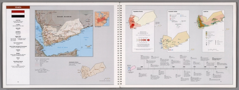
United States. Central Intelligence Agency
Full Title
Yemen. (insets) Area comparison. (with) Administrative divisions. (with) Historic Yemen (North Yemen). (to accompany) Central Intelligence Agency : Atlas of the Middle East. January 1993.
List No
8467.033
Note
4 color maps on 2 pages. Lambert Conformal Conic Projection. Large map shows national capital, expressway, roads, track and populated areas. Small maps showing population density, economic activity and land use. Includes national flag, explanatory text and historical chart.
Author
[Geographisches Institut (Weimar, Germany), Weiland, Carl Ferdinand, 1782 -1847]
Full Title
Arabien. (Arabia). (insets) Charte von den Umgebungen von Derayeh. Das Petraeische Araben.
List No
9074.050
1-21 of 21
|
![يمن ولايتى خريطة سى [Yemen Vilâyeti haritasi / Map of Yemen Vilayet].](https://www.davidrumsey.com/rumsey/Size2/RUMSEY~8~1/205/15428000.jpg)