|
REFINE
Browse All : Images of World from 1865
1-40 of 40
Author
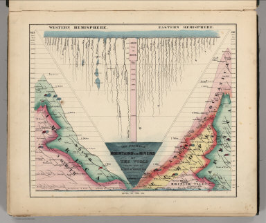
Schonberg & Co.
Full Title
The Principal Mountains and Rivers of the World compiled from the Latest Authorities. New York. Schonberg & Co. 1864.
List No
4324.004
Note
Shows lengths of major rivers and heights of mountains; differentiated by hemisphere.
Author
Johnson, A.J.
Full Title
Johnson's Chart of Comparative Heights of Mountains and Lengths of Rivers of ... Africa, Asia, Europe, South America, and North America.
List No
0535.005
Note
Consists of five charts on one sheet.
Author
Bacon & Co.
Full Title
The Atlantic Telegraph. Map Shewing the Atlantic Telegraph, and Other Submarine Cables in Europe and America. Map Showing the Proposed Ocean Telegraphs and Overland Route Around the World.
List No
12183.000
Author
Colton, G.W.
Full Title
(Title Page to) Colton's General Atlas, Containing One Hundred And Eighty Steel Plate Maps And Plans, On One Hundred And Eight Imperial Folio Sheets, Drawn By G. Woolworth Colton. Letter-Press Descriptions, Geographical, Statistical, And Historical, By Richard Swainson Fisher. New York: J.H. Colton, No. 172 William Street. London: Bacon & Co., 48 Paternoster Row. 1865. Entered ... 1863, by J.H. Colton ... New York.
List No
0151.004
Author
Colton, G.W.
Full Title
Map of the World Illustrating the Principal Features of The Land and the Co-Tidal Lines. Map of the World Illustrating the Principal Features of Meteorology. Map of the World Showing the Geographical Distribution and Range of the Principal Members of Animal Kingdom. Map of the World Showing the Principal Ocean Currents and Boundaries of River Systems. Map of the World Showing the Distribution and Limits of Cultivation of the Principal Plants Useful to Mankind. Map of the World illustrating the Productive Industry of Various Countries & Exhibiting the Principal Features of Commerce and Navigation. Published by J. H. Colton. No. 172 William St. New York.
List No
0151.012
Note
A selection of thematic maps illustrating the Land and Tidal Lines, Meteorology, Animal Kingdom, Ocean Currents and River Systems, Principal Plants, and Productive Industry of the World. (Inset) Rain Map. Bird Map. and Chart showing the Vertical Range of Various Plants. Prime meridian is Greenwich.
Author
Johnson, A.J.
Full Title
(Half Title Page to) Johnson's New Illustrated (Steel Plate) Family Atlas, With Physical Geography, And With Descriptions Geographical, Statistical, And Historical Including the Latest Federal Census, A Geographical Index, and a Chronological History of the Civil War in America. By Richard Swainson Fisher, M.D. ... Maps Compiled, Drawn, And Engraved Under The Supervision Of J.H. Colton And A.J. Johnson... New York: Johnson And Ward, Successors To Johnson And Browning Who Were (Successors To J.H. Colton And Company,) No. 113 Fulton Street. 1865. Entered ... One Thousand Eight Hundred and Sixty-four, by A.J. Johnson ... New York.
List No
0535.002
Note
Title on page reads "American Atlas" and is accompanied by an illustration of Indians on a bluff overlooking a river, steamboat, factory, town and homestead.
Author
Johnson, A.J.
Full Title
(Title Page to) Johnson's New Illustrated (Steel Plate) Family Atlas, With Physical Geography, And With Descriptions Geographical, Statistical, And Historical Including the Latest Federal Census, A Geographical Index, and a Chronological History of the Civil War in America. By Richard Swainson Fisher, M.D. ... Maps Compiled, Drawn, And Engraved Under The Supervision Of J.H. Colton And A.J. Johnson... New York: Johnson And Ward, Successors To Johnson And Browning Who Were (Successors To J.H. Colton And Company,) No. 113 Fulton Street. 1865. Entered ... One Thousand Eight Hundred and Sixty-four, by A.J. Johnson ... New York.
List No
0535.003
Author
Johnson, A.J.
Full Title
(Index Page to) Johnson's New Illustrated (Steel Plate) Family Atlas, With Physical Geography, And With Descriptions Geographical, Statistical, And Historical Including the Latest Federal Census, A Geographical Index, and a Chronological History of the Civil War in America. By Richard Swainson Fisher, M.D. ... Maps Compiled, Drawn, And Engraved Under The Supervision Of J.H. Colton And A.J. Johnson... New York: Johnson And Ward, Successors To Johnson And Browning Who Were (Successors To J.H. Colton And Company,) No. 113 Fulton Street. 1865. Entered ... One Thousand Eight Hundred and Sixty-four, by A.J. Johnson ... New York.
List No
0535.004
Author
Johnson, A.J.
Full Title
Johnson's New Chart of National Emblems (Flags). Published by Johnson & Ward.
List No
0535.006
Author
Johnson, A.J.
Full Title
Johnson's Map of The World Showing the Geographical Distribution & Range of The Principal Members of The Animal Kingdom (with) Bird Map. Johnson's Map of The World Illustrating the Productive Industry Of Various Countries, & exhibiting the principal features of Commerce And Navigation. Johnson's Map Showing the Principal Ocean Currents and Boundaries of the River Systems. Johnson's Map Illustrating the Principal Features of Meteorology (with) Rain Map. Johnson's Map Illustrating the Principal Features of the Land and the Co-tidal Lines. Johnson's Map Showing the Distribution and Limits of Cultivation of the Principal Plants Useful to Mankind.
List No
0535.009
Note
Six small maps with insets of smaller maps of birds and rain.
Author
Johnson, A.J.
Full Title
Johnson's World on Mercators Projection Published by Johnson and Ward.
List No
0535.012
Note
Meridians Greenwich and Washington D.C. Relief shown by hachures.
Author
Mitchell, Samuel Augustus Jr.
Full Title
(Text Page to) Mitchell's New General Atlas, Containing Maps Of The Various Countries Of The World, Plans Of Cities, Etc., Embraced In Fifty-Five Quarto Maps, Forming A Series Of Eighty-Seven Maps And Plans, Together With Valuable Statistical Tables. Philadelphia: Published By S. Augustus Mitchell, Jr. No. 31 South Sixth Street. 1865. Entered ... 1860, by S. Augustus Mitchell, Jr. ... Pennsylvania.
List No
0572.002
Note
Pennsylvania, and New Jersey, Maryland and Delaware are split into two maps in this edition, as opposed to being combined in previous years. This copy also includes a new map of Utah and Nevada, and Idaho and Montana are now shown on the Oregon and Washington map. Maps have full hand painted color. Atlas is bound in embossed half leather brown cloth covered boards with "Mitchell's New General Atlas" stamped in gilt.
Author
Mitchell, Samuel Augustus Jr.
Full Title
(Title Page to) Mitchell's New General Atlas, Containing Maps Of The Various Countries Of The World, Plans Of Cities, Etc., Embraced In Fifty-Five Quarto Maps, Forming A Series Of Eighty-Seven Maps And Plans, Together With Valuable Statistical Tables. Philadelphia: Published By S. Augustus Mitchell, Jr. No. 31 South Sixth Street. 1865. Entered ... 1860, by S. Augustus Mitchell, Jr. ... Pennsylvania.
List No
0572.003
Note
Pennsylvania, and New Jersey, Maryland and Delaware are split into two maps in this edition, as opposed to being combined in previous years. This copy also includes a new map of Utah and Nevada, and Idaho and Montana are now shown on the Oregon and Washington map. Maps have full hand painted color. Atlas is bound in embossed half leather brown cloth covered boards with "Mitchell's New General Atlas" stamped in gilt.
Author
Mitchell, Samuel Augustus Jr.
Full Title
(Contents to) Mitchell's New General Atlas, Containing Maps Of The Various Countries Of The World, Plans Of Cities, Etc., Embraced In Fifty-Five Quarto Maps, Forming A Series Of Eighty-Seven Maps And Plans, Together With Valuable Statistical Tables. Philadelphia: Published By S. Augustus Mitchell, Jr. No. 31 South Sixth Street. 1865. Entered ... 1860, by S. Augustus Mitchell, Jr. ... Pennsylvania.
List No
0572.004
Note
Pennsylvania, and New Jersey, Maryland and Delaware are split into two maps in this edition, as opposed to being combined in previous years. This copy also includes a new map of Utah and Nevada, and Idaho and Montana are now shown on the Oregon and Washington map. Maps have full hand painted color. Atlas is bound in embossed half leather brown cloth covered boards with "Mitchell's New General Atlas" stamped in gilt.
Author
Mitchell, Samuel Augustus Jr.
Full Title
The World in Hemispheres. With others Projections &c.&c. Constructed & Engraved by W. Williams Philadelphia. Entered ... 1860, by S. Augustus Mitchell, Jr. ... Pennsylvania. (insets) North Polar Region. The World on a Polar Projection. Land and Water Hemispheres.
List No
0572.005
Note
Double hemisphere map in full color by continent. Includes chart showing lengths of rivers.
Author
Mitchell, Samuel Augustus Jr.
Full Title
A time table indicating the difference in time between the principal cities of the World and also showing their air-line distance from Washington. Entered ... 1864 by S. Augustus Mitchell, Jr. ... Pennsylvania.
List No
0572.006
Note
Hand colored Lithographed. With legend showing distribution of colors: N.S America, Europe, Asia, and Africa.
Author
Mitchell, Samuel Augustus Jr.
Full Title
Map of the World in Mercator projection. Exhibiting the American Continents as its center. Entered ... 1864 by S. Augustus Mitchell, Jr. ... Pennsylvania.
List No
0572.007
Note
Hand colored. Relief shown by hachures. Shows dated routes of ocean explorations, indicating the explorers.
Author
[Menke, Th., Spruner von Merz, Karl]
Full Title
(Title Page to) Spruner-Menke atlas antiquus. Karoli Spruneri opus. Tertio edidit, Theodorus Menke. Gothae: Sumtibus Justi Perthes, anno MDCCCLXV.
List No
1626B
Note
Maps are hand painted in outline color and bound in half leather teal cloth covered boards with "v.Spruner's Histor. Atlas. Atlas Antiquus." stamped on the cover, and "Spruner Histor. Atlas" stamped on the spine in gold. Title page includes table of contents: Insunt tabulae hae. Latest map (pl. XVIIII) corrected to 1868. Originally published in 1850 as the first part of Spruner's historisch-geographischer hand-atlas, issued in 3 parts, 1846-51. 2nd edition published in 1855.
Author
[Menke, Th., Spruner von Merz, Karl]
Full Title
(Text Page to) Spruner-Menke atlas antiquus. Karoli Spruneri opus. Tertio edidit, Theodorus Menke. Gothae: Sumtibus Justi Perthes, anno MDCCCLXV.
List No
1626C
Note
Explanation of the maps.
Author
[Menke, Th., Spruner von Merz, Karl]
Full Title
(Text Page to) Spruner-Menke atlas antiquus. Karoli Spruneri opus. Tertio edidit, Theodorus Menke. Gothae: Sumtibus Justi Perthes, anno MDCCCLXV.
List No
1626D
Note
Explanation of the maps continued. "*1" below text.
Author
[Menke, Th., Spruner von Merz, Karl]
Full Title
(Text Page to) Spruner-Menke atlas antiquus. Karoli Spruneri opus. Tertio edidit, Theodorus Menke. Gothae: Sumtibus Justi Perthes, anno MDCCCLXV.
List No
1626E
Note
Explanation of the maps continued.
Author
[Menke, Th., Spruner von Merz, Karl]
Full Title
(Text Page to) Spruner-Menke atlas antiquus. Karoli Spruneri opus. Tertio edidit, Theodorus Menke. Gothae: Sumtibus Justi Perthes, anno MDCCCLXV.
List No
1626F
Note
Explanation of the maps continued.
Author
[Menke, Th., Spruner von Merz, Karl]
Full Title
(Text Page to) Spruner-Menke atlas antiquus. Karoli Spruneri opus. Tertio edidit, Theodorus Menke. Gothae: Sumtibus Justi Perthes, anno MDCCCLXV.
List No
1626G
Note
Explanation of the maps continued.
Author
[Menke, Th., Spruner von Merz, Karl]
Full Title
(Text Page to) Spruner-Menke atlas antiquus. Karoli Spruneri opus. Tertio edidit, Theodorus Menke. Gothae: Sumtibus Justi Perthes, anno MDCCCLXV.
List No
1626H
Note
Explanation of the maps continued.
Author
[Menke, Th., Spruner von Merz, Karl]
Full Title
(Text Page to) Spruner-Menke atlas antiquus. Karoli Spruneri opus. Tertio edidit, Theodorus Menke. Gothae: Sumtibus Justi Perthes, anno MDCCCLXV.
List No
1626I
Note
Explanation of the maps continued.
Author
[Menke, Th., Spruner von Merz, Karl]
Full Title
(Text Page to) Spruner-Menke atlas antiquus. Karoli Spruneri opus. Tertio edidit, Theodorus Menke. Gothae: Sumtibus Justi Perthes, anno MDCCCLXV.
List No
1626J
Note
Explanation of the maps continued.
Author
[Menke, Th., Spruner von Merz, Karl]
Full Title
(Text Page to) Spruner-Menke atlas antiquus. Karoli Spruneri opus. Tertio edidit, Theodorus Menke. Gothae: Sumtibus Justi Perthes, anno MDCCCLXV.
List No
1626K
Note
Explanation of the maps continued. On verso of p. 17: Druck der Engelhard-Reyher'schen Hofbuchdruckerei in Gotha.
Author
[Herodotus, Homer, Menke, Th., Spruner von Merz, Karl]
Full Title
Orbis terrarum ad mentem Homeri. Orbis Terrarum ad mentem Herodoti. Orbis terrarum ad mentem Strabonis. Orbis terrarum Graecis atque Romanis Ptolemaei tempore notus. Orbis terrarum ad mentem Ptolemaei. F.v. Stulpnagel del. Gothae: Justhus Perthes. Spruner-Menke atlas antiquus. (1865)
List No
1626.001
Note
Five hand colored maps. Relief shown by hachures. Inset: Modi duo, quibus orbem terrarum in plano describi posse Ptolemaeus auctor est. Prime meridian: Ferro.
Author
[Menke, Th., Spruner von Merz, Karl]
Full Title
Orbis terrarum regni Assyrii tempore. (with) Aegyptus, Aethiopia. (with) Pyramides. (with) Pyramides memphiticae (prope Gizeh). (with) Thebae, Diospolis. (with) Ninus, significatione propria et principali. (with) Orbis terrarum ad mentem Hebraeorum. F.v. Stulpnagel del. (Gothae: Justhus Perthes). Spruner-Menke atlas antiquus. (1865)
List No
1626.002
Note
Hand colored map. Relief shown by hachures. Prime meridian: Ferro.
Author
Society for the Diffusion of Useful Knowledge (Great Britain)
Full Title
The World as Known to the Ancients. Sheet I.
List No
2326.005
Author
Society for the Diffusion of Useful Knowledge (Great Britain)
Full Title
The World as Known to the Ancients. Sheet II.
List No
2326.006
Author
Society for the Diffusion of Useful Knowledge (Great Britain)
Full Title
(Composite) The World as Known to the Ancients.
List No
2326.007
Author
Mitchell, Samuel Augustus Jr., 1792-1868
Full Title
Map of the World as known to the ancients. (to accompany) Mitchell's New Reference Atlas for the Use of Colleges, Libraries, Families and Counting Houses. Philadelphia: Published By E.H. Butler & Co. 1865. (insets) Comparative map of the World. (with) The World according to Ptolemy.
List No
2516.037
Note
Hand colored map of the world in the days of Alexander the Great. Relief shown by hachures. Shows the portions of the three continents that were known in pastel colors, the ancient cities and towns. Noted the route Alexander took from Greece to India and back to Babylon. Two inset maps show the modern world map and Ptolemy's ancient map. Prime meridians are Greenwich and Washington. Includes explanation and notes.
Author
Stein, Christ. Gottfr. Dan.
Full Title
(Title Page to) Neuer Atlas der ganzen Erde fur die Gebildeten aller Stande und fur hohere Lehranstalten. Zweiunddreissigste Auflage. Achtundzwanzig Karten, mit Berucksichtigung der geographisch-statistischen Werke von Dr. C.G.D. Stein und Anderen, entworfen und gezeichnet von J.M. Ziegler, Dr. H. Lange, G. Heck u.A., nebst siebzehn Zeittafeln und dreissig statistischen Tabellen uber alle Lander und Staaten der Erde, begrundet von Prof. Dr. K. Th. Wagner, neu bearbeitet und erganzt von O. Delitsch und Prof. Dr. H.F. Brachelli. Leipzig, J.C. Hinrichs'sche Buch- und Landkartenhandlung. (1865)
List No
3134B
Note
32nd Edition. Maps by Ziegler, Lange, Heck and others. Very good large two sheet map of the United States shows the Confederate states as a separate country. All the maps are engraved and hand painted with outline color. Covers are gray paper covered boards with the title printed on the front cover in black ink.
Author
Stein, Christ. Gottfr. Dan.
Full Title
(Contents Page to) Neuer Atlas der ganzen Erde fur die Gebildeten aller Stande und fur hohere Lehranstalten. Zweiunddreissigste Auflage. Achtundzwanzig Karten, mit Berucksichtigung der geographisch-statistischen Werke von Dr. C.G.D. Stein und Anderen, entworfen und gezeichnet von J.M. Ziegler, Dr. H. Lange, G. Heck u.A., nebst siebzehn Zeittafeln und dreissig statistischen Tabellen uber alle Lander und Staaten der Erde, begrundet von Prof. Dr. K. Th. Wagner, neu bearbeitet und erganzt von O. Delitsch und Prof. Dr. H.F. Brachelli. Leipzig, J.C. Hinrichs'sche Buch- und Landkartenhandlung. (1865)
List No
3134C
Note
"Inhalt." "Buch und Kupferdruck von Giesecke & Devrient in Leipzig."
Author
Stein, Christ. Gottfr. Dan.
Full Title
Hemisphaeren. Entworfen und gezeichnet von G. Heck. Gestochen von R. Schmidt u. H. Eberhardt. J.C. Hinrichs'sche Buchhandlung, Leipzig. (1865)
List No
3134.001
Note
Hand colored double hemisphere map. Relief shown by hachures. Insets: Nordliche Hemisphare -- Nordliche Polar-Lander -- Hemisphare f.d. grosste Landermasse -- Sudliche Hemisphare -- Sudliche Polar-Laender -- Hemisphare f.d. grosste Wassermasse -- Querprofil durch Nordamerica in der Richtung d. 35 (degrees) n. B. -- Langenprofil durch Europa in der Richtung d. 30 (degrees) ostl. L. -- Querprofil durch Sudamerika, in der Richtung des 15 (degrees) sudl. Be -- Langenprofil durch Mittelasien, in der Richtung d. 100 (degrees) ostl. Le. Prime meridian: Ferro. "Stein, Neuer Atlas der ganzen Erde."
Author
Schonberg & Co.
Full Title
(Title Page to) Schonberg's Standard Atlas Of The World. New York, Schonberg And Company. 1865. Boston: Benj. B. Russell, 515 Washington St. Chicago: R.R. Landon, Agent, 88 Lake St. (on verso) ... Entered ... 1863, by Schonberg & Co. ... New York.
List No
4324.002
Note
Includes a captivating large vignette with a radiant sun and five women and three cherubs with the instruments of geography (sextant, globes, map, telescope, notebook, etc.). The landscape is wild with trees, islands, and rugged topography. Ships of various types also shown.
Author
Johnson, Alvin Jewett, 1827-1884.
Full Title
Johnson's world on Mercators projection. Published by Alvin Johnson & Son New York. Entered ... 1865, by A.J. Johnson ... New York. (to accompany) Johnson's New Illustrated Family Atlas Of The World ... MDCCCLXXX (1880).
List No
4830.062
Note
Engraved hand colored in outline map on 2 sheets. Shows continents, national borders, rivers, mountain ranges and exploration routes of Captain Cook and Captain Wilkes. Relief shown by hachures. Prime meridians are Washington and Greenwich.
Author
[Dufour, Auguste-Henri (1798-1865), Dyonnet, Charles]
Full Title
Monde connu des anciens : Dresse par A.H. Dufour. Gravee par Ch. Dyonnet. Armand Le Chevalier, Rue Richelieu, 60. Paris. 1865. Impe. par Louis Antonie, r. de Cluny 1, Paris. (insets) Geographie d'Herodote. (with) Systeme de Petolemee. (to accompany) Atlas Universel, Physique, Historique Et Politique De Geographie Ancienne Et Moderne. (on upper margin) Geographie ancienne Pl. 2.
List No
5020.005
Note
Outline hand color map of the Ancient World, including Asia, Europe and Africa, Arabia, part of Asia including the Indian Subcontinent and the northern part of Africa. Relief shown by hachures. Prime meridian is Paris.
Author
[Dufour, Auguste-Henri (1798-1865), Dyonnet, Charles]
Full Title
Mappe - Monde : Planispherrique, physique et hydrographique : Dresse par A.H. Dufour. Gravee par Ch. Dyonnet 1863. Paris, Armand Le Chevalier, Rue Richelieu, 60. La Lettre gravee par Deletre. Impe. par Louis Antonie, r. de Cluny 1, Paris. (to accompany) Atlas Universel, Physique, Historique Et Politique De Geographie Ancienne Et Moderne. Pl. 10. (on upper margin) Geographie moderne. Pl. 1.
List No
5020.013
Note
Hand color used to outline continents. Shows sea routes of various explorers. Includes notes and list of European possession in color. Relief shown by hachures. Prime meridian is Paris.
1-40 of 40
|