|
REFINE
Browse All : Images of World from 1818
1-10 of 10
Author
Wyld, James, 1790-1836
Full Title
Chart of the World Shewing the Religion, Population and Civilization of Each Country.
List No
10900.000
Author
[Lizars, William Home, 1788-1859, Lizars, Daniel]
Full Title
Chart of the world on Mercators projection. Published by T. Brown & W. & D. Lizars, Edinr. (to accompany) New Edinburgh general atlas ... The maps drawn and engraved by W. & D. Lizars.
List No
13230.009
Note
Hand color engraved map on 2 sheets. Shows political boundaries and explorers' tracks. Relief shown by hachures.
Author
[Zurla, Placido, 1769-1834, Mauro, Fra]
Full Title
Abbozzo Del Mappamondo Di F: Mauro Camaldolese Cosmografo Incomparabile alla Meta del Sec. XV. Gia' Esistnet Neall Bilblioteca Di S. Michele Di Murano Ora Nella Marciana. (to accompany) Sulle antiche mappe idro - geografiche lavorate in Venezia.
List No
11171.006
Note
Uncolored circular planisphere world map of Fra Mauro Camaldolese. Described and illustrated by Placido Zurla, the map is believed to have been made around 1450 by the Venetian monk Fra Mauro, one of the few extent early facsimiles of early world maps. Fra Mauro's pre-Columbian World map is considered the greatest memorial of medieval cartography. The original Mauro map was discovered in the monastery of San Michel in Isola, Murano, where the Camaldolese cartographer had his studio. Relief shown pictorially. Includes 4 circular insets.
Author
Wilkinson, Robert
Full Title
The World as Peopled by the Descendants of Noah Shewing the Countries Possessed by Shem, Ham & Japhet and their posterity after the confusion of tongues.
List No
1203.005
Author
Carey, Mathew
Full Title
(Title Page to) Carey's General Atlas, Improved And Enlarged; Being A Collection Of Maps Of The World And Quarters, Their Principal Empires, Kingdoms, &c. Containing...[Sequential List of Maps]. Philadelphia: Published By M. Carey And Son, 1818.
List No
2721.002
Author
Carey, Mathew
Full Title
(Prefatory Remarks 1 to) Carey's General Atlas, Improved And Enlarged; Being A Collection Of Maps Of The World And Quarters, Their Principal Empires, Kingdoms, &c. Containing...[List of Maps]. Philadelphia: Published By M. Carey And Son, 1818.
List No
2721.003
Author
Carey, Mathew
Full Title
(Prefatory Remarks 2 to) Carey's General Atlas, Improved And Enlarged; Being A Collection Of Maps Of The World And Quarters, Their Principal Empires, Kingdoms, &c. Containing...[List of Maps]. Philadelphia: Published By M. Carey And Son, 1818.
List No
2721.004
Note
Page includes alphabetical list of maps.
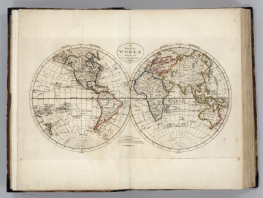
Author
Carey, Mathew
Full Title
A Map of the World from the best Authorities. J. Bower, Sc.
List No
2721.006
Note
Double hemisphere map in outline color. Three routes of Captain Cook shown from 1768-1771, 1772-1775, and 1776-1780. Prime meridian London. Major relief shown by sketches.
Author
Carey, Mathew
Full Title
A Chart of the World According to Mercators Projection, Shewing the latest Discoveries of Capt. Cook.
List No
2721.007
Note
Mercator projection shown in outline color. Three routes of Captain Cook shown from 1768-1771, 1772-1775, and 1776-1780. Prime meridian London.
Author
[Cary, John, ca. 1754-1835, Cary, William]
Full Title
Cary's New Terrestrial Globe Exhibiting The Tracks and Discoveries made by Captain Cook; Also those of Captain Vancouver on the Northwest Coast of America and M. De La Perouse, On the Coast of Tartary, Together With every other Improvement collected from Various Navigators and Travellers to the present time. London: Made & Sold by J. & W. Cary, Strand, March 1st, 1816. With Corrections and Additions to 1818.
List No
3401.000
Note
Dated March 1st, 1816, With Corrections and Additions to 1818. 2nd edition, 1st edition was either 1816 or 1817 depending on the authority. Uses Arrowsmith for the American Northwest. Cary issued globes in 3.5", 9", 12" and 21" sizes starting in 1792 (Fordham) and added the 18" in 1816/17. During this period he issued the globes with his brother William, later with his brother George. The globe is beautifully drawn with precision in a style similar to Cary's maps, lacking any ornamentation. The stand is a four leg table type, with horizon ring. An 18-inch globe, measuring 25-inches from base to tip.
1-10 of 10
|