|
REFINE
Browse All : Images of World and West Indies
1-8 of 8
Author
Henze, Adolf
Full Title
Section 19 Henze's Erd-Globus.
List No
10681.019
Note
With a diameter of 43 inches, these 24 gores form the largest printed globe produced in the 19th century.Dimensions are sheet size.
Author
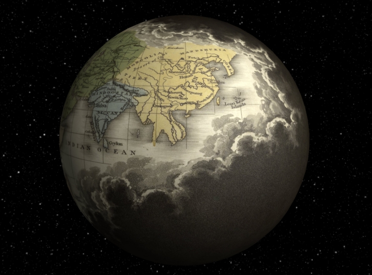
Quin, Edward
Full Title
(Interactive Globe) A.D. 1498. The Discovery Of America. Engraved by Sidy. Hall Bury Strt. Bloomsby. London, Published by Seeley & Burnside, 169, Fleet Street, Jany. 1830.
List No
2839.091
Note
The fold out map shows clouds around the outer edges of the map depicting the known world from the division of the Mogul Empire, A.D. 1294, to the discovery of America, A.D. 1498. Sixteenth period. Africa is fully shown for the first time and the East Coast of America from Newfoundland to the northern edge of South America. The West Indies are shown in blue.
Author
Johnston, Alexander Keith, 1804-1871
Full Title
The geographical distribution of health & disease, in connection chiefly with natural phenomena. (with) Fever districts of United States & W. Indies, on an enlarged scale. By A. Keith Johnston, F.R.S.E. &c. Engraved by W. & A.K. Johnston, Edinburgh. William Blackwood & Sons, Edinburgh & London. (1856)
List No
0372.036
Note
Col. lithographed map with inset. Graphs: Consumption: proportion of deaths in the different quarters of the globe -- Rheumatism: proportion of attacks among the troops in the different quarters of the globe -- Comparative value of life in different countries -- Comparative value of life in cities and towns -- Proportionate mortality of European residents in foreign countries. "Phytology & zoology no. 12."
Author
[Quin, Edward, Hughes, W., Gilmour & Dean]
Full Title
Sixteenth period : A.D. 1498. The Discovery Of America. Drawn & engraved by W. Hughes. Printed by Gilmour & Dean. Glasgow. (to accompany) An Historical Atlas: In A Series Of Maps Of The World As Known At Different Periods ... New Edition. London And Glasgow: Richard Griffin And Company.
List No
0743.056
Note
Hand colored folded map of the world on sheet 67x101. Showing clouds around the outer edges of the map depicting the known world from the division of the Mogul Empire, A.D. 1294, to the discovery of America, A.D. 1498. Empires and countries identified by color. Africa is fully shown and the East Coast of America from Newfoundland to the northern edge of South America. Includes explanation.
Full Title
British Empire, showing the commercial routes of the World and ocean currents. (with) Steam-ship lines of Central America & the West Indies. (with) Steam-ship lines from ports of Western Europe. (with) Eastern steam-ship lines (Mediterranean and Black Seas. Published at the office of "The Times," London, 1895)
List No
1010.005
Note
Color map with 3 ancillary maps. Also shows overland and submarine telegraph cables, principal railways, limits of floating ice, etc.
Author
[Bartholomew, J.G., Herbertson, A.J., Supan, A., Meeson, J.T., Moore, W.L.]
Full Title
Plate 21. Isobars & Isohyets - Various Countries.
List No
12430.031
Author
News Map of the Week, Inc.
Full Title
World News of the Week : Monday, Nov. 14, 1949. Covering period Nov. 4 to Nov. 10. Volume 12, No. 11. Published and copyrighted (weekly), 1949, by News Map of the Week, Inc., 1512 Orleans Street, Chicago, Illinois. Published in two sections : Section one. Lithographed in U. S. A.
List No
14209.000
Note
Lithographed world map, in color. Shows political boundaries and significant events from November 4 to 10, 1949. Relief illustrated with hachures. Includes information on the Siberian River Project, with explanatory text. Map indexed according to historical notes beneath map. With inset map: British plan for West Indies. Also, with diagram: Aid to children. Map is 56 x 115 cm, on sheet 89 x 120 cm, folded to 31 x 23 cm.
Author
[Andree, Richard, Times (London, England)]
Full Title
British Empire, showing the commercial routes of the World and ocean currents. (with 3 insets) Steam-ship lines of Central America & the West Indies. Steam-ship lines from ports of Western Europe. Eastern Steam-ship lines (Mediterranean and Black Seas. Published at the office of "The Times," London, 1900).
List No
6809.009
Note
Color map, and 3 insets on 2 sheets. Shows overland and submarine telegraph cables, principal railways,steam ship lines with duration, etc. Prime meridian is Greenwich.
1-8 of 8
|