|
Author
News Map of the Week, Inc.
Full Title
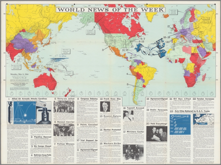
World News of the Week : Monday, May 8, 1944. Covering period Apr. 28 to May 4. Volume 6, No. 36. Published and copyrighted (weekly), 1944, by News Map of the Week, Inc., 1512 Orleans Street, Chicago, Illinois. Published in two sections : Section one. Lithographed in U. S. A.
List No
14170.000
Note
Lithographed world map, in color. Shows political boundaries and military events of World War II, from April 28 to May 4, 1944. Relief illustrated with hachures. Descriptive text throughout, e.g.: Ft. Norman - Whitehorse oil pipeline opened. Map indexed according to historical notes beneath map. Features photographs, illustrations, and international time zones. With inset map: (European communication networks). Also, with two diagrams: (Photo flash bomb) -- Bombing tons dropped on Axis Europe. Map is 56 x 115 cm, on sheet 89 x 120 cm, folded to 31 x 23 cm.
Author
News Map of the Week, Inc.
Full Title
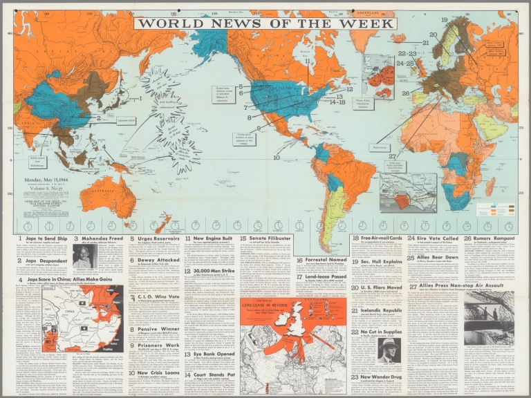
World News of the Week : Monday, May 15, 1944. Covering period May 5 to May 11. Volume 6, No. 37. Published and copyrighted (weekly), 1944, by News Map of the Week, Inc., 1512 Orleans Street, Chicago, Illinois. Published in two sections : Section one. Lithographed in U. S. A.
List No
14172.000
Note
Lithographed world map, in color. Shows political boundaries and military events of World War II, from May 5 to 11, 1944. Relief illustrated with hachures. Includes a key indicating the alignment of warring nations (United, Axis, and neutral). Descriptive text throughout, e.g.: Nazis note Anzio activities; flood Pontine Marshes. Map indexed according to historical notes beneath map. Features photographs, illustrations, and international time zones. With four inset maps: (Where Allies concentrate bombers in Europe) -- (Pontine Marshes) -- (China) -- Great Britain and Land-Lease in reverse. Map is 56 x 115 cm, on sheet 89 x 120 cm, folded to 31 x 23 cm.
Hickmann, Anton Leo, 1834-1906; Fischer,... Ideale ansichtder bedeutendsten hohen un... 1927 13687.008 Related Author
[Hickmann, Anton Leo, 1834-1906, Fischer, Alois, b. 1894]
Full Title
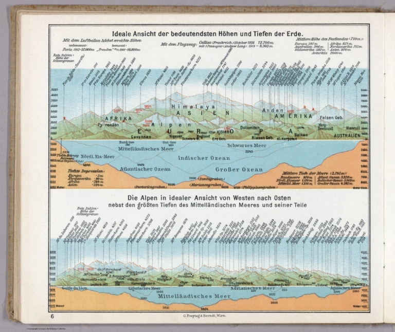
Ideale ansichtder bedeutendsten hohen und Tiefen und Tiefen der erde. G. Freytag & Berndt A.G., Wien. (to accompany) Prof. Hickmann's Geographisch-statistischer universal-atlas, 1927.
List No
13687.008
Note
4 views on 1 sheet. Including comparative view of the Heights of the Principal Mountains and depths of seas in the world. With comparative view of the elevations of the Alps and the depth of the Mediterranean Sea. Relief shown by spot heights. Depth shown by soundings.
Hickmann, Anton Leo, 1834-1906; Fischer,... Die Religionen der Erde. Die Religionen ... 1927 13687.042 Related Author
[Hickmann, Anton Leo, 1834-1906, Fischer, Alois, b. 1894]
Full Title
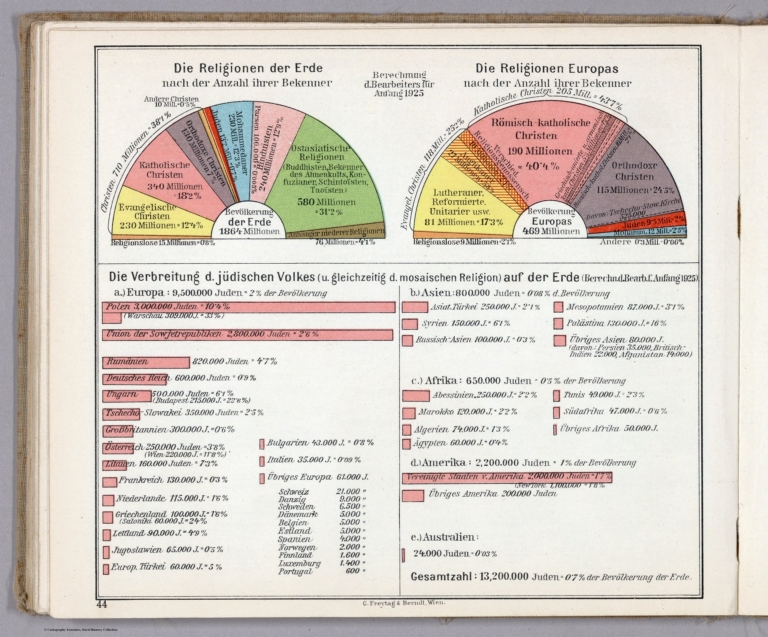
Die Religionen der Erde. Die Religionen Europas. G. Freytag & Berndt A.G., Wien. (to accompany) Prof. Hickmann's Geographisch-statistischer universal-atlas, 1927.
List No
13687.042
Note
Statistical diagrams. Showing the religions of the world and the religions of Europe. Charts showing the spread Jewish people in and Mosaic people in Europe and in the world.
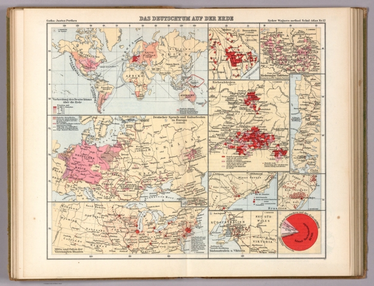
Sydow, Emil von., 1812-1873; Wagner, Her... No. 12. Das Deutschtum auf der Erde 1940 13557.038 Related Author
[Sydow, Emil von., 1812-1873, Wagner, Hermann, 1840-1929]
Full Title
Das Deutschtum auf der Erde. Gotha : Justus Perthes. Sydow-Wagners method. Schul-Atlas : 21 Auflage. 1940.
List No
13557.038
Note
Map of the world, with 10 insets. Showing the spread of Germans on Earth.
Author
News Map of the Week, Inc.
Full Title
World News of the Week : Monday, Nov. 22, 1943. Covering period Nov. 12 to Nov. 18. Volume 6, No. 12. Published and copyrighted (weekly), 1943, by News Map of the Week, Inc., 1512 Orleans Street, Chicago, Illinois. Published in two sections : Section one. Lithographed in U. S. A.
List No
14144.000
Note
Lithographed world map, in color. Shows political boundaries and military events of World War II, from November 12 to 18, 1943. Relief illustrated with hachures. Includes a key indicating the alignment of warring nations (United, Axis, and neutral). Descriptive text throughout, e.g.: Nazis capture Leros island. Map indexed according to historical notes beneath map. Features photographs, illustrations, and international time zones. With two inset maps: Bougainville close-up -- Hitler's headache. Map is 56 x 115 cm, on sheet 89 x 120 cm, folded to 31 x 23 cm.
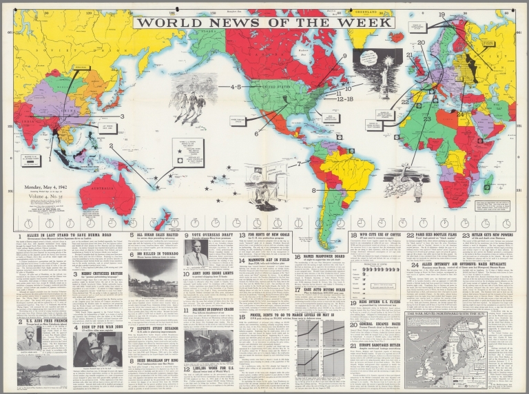
Author
News Map of the Week, Inc.
Full Title
World News of the Week : Monday, May 4, 1942. Covering period Apr. 24 to 30. Volume 4, No. 35. Published and copyrighted (weekly), 1942, by News Map of the Week, Inc., 1512 Orleans Street, Chicago, Illinois. Published in two sections : Section one. Lithographed in U. S. A.
List No
14097.000
Note
Lithographed world map, in color. Shows political boundaries and military events of World War II, from April 24 to 30, 1942. Relief illustrated with hachures. Includes a legend indicating control by the Free French and Vichy France. Descriptive text throughout, e.g.: Area subject to semi-blackout. Map indexed according to historical notes beneath map. Features photographs, illustrations, and international time zones. With inset map: The War moves northward with the sun. Also, with diagram: Factory wages; Food prices; Income taxes; Installment buying. Map is 56 x 115 cm, on sheet 89 x 120 cm, folded to 31 x 23 cm.
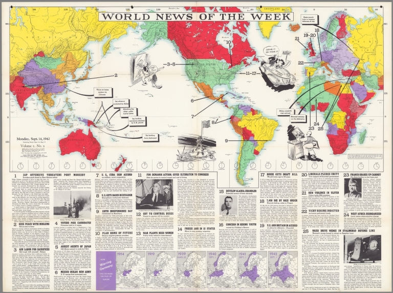
Author
News Map of the Week, Inc.
Full Title
World News of the Week : Monday, Sept. 14, 1942. Covering period Sept. 4 to Sept. 10. Volume 5, No. 2. Published and copyrighted (weekly), 1942, by News Map of the Week, Inc., 1512 Orleans Street, Chicago, Illinois. Published in two sections : Section one. Lithographed in U. S. A.
List No
14104.000
Note
Lithographed world map, in color. Shows political boundaries and military events of World War II, from September 4 to 10, 1942. Relief illustrated with hachures. Descriptive text throughout, e.g.: Allies complete vital railroad. Map indexed according to historical notes beneath map. Features photographs, illustrations, and international time zones. With six inset maps: How warring Germany has changed the face of Europe : 1914 -- 1919 -- 1939, Mar. 22 -- 1940, Sept. 1 -- 1941, Sept. 1 -- 1942, Sept. 1. Map is 56 x 115 cm, on sheet 89 x 120 cm, folded to 31 x 23 cm.
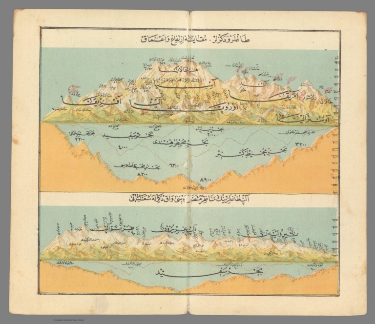
Author
Anonymous
Full Title
Dağlar ve dakjez lar ... = Mountains and seas. Alps daglerink = Alps daglerink ... اغلر ودكزار
List No
13531.000
Author
Henze, Adolf
Full Title
Section 1 Henze's Erd-Globus.
List No
10681.001
Note
With a diameter of 43 inches, these 24 gores form the largest printed globe produced in the 19th century.Dimensions are sheet size.
Author
Henze, Adolf
Full Title
Section 21 Henze's Erd-Globus.
List No
10681.023
Note
With a diameter of 43 inches, these 24 gores form the largest printed globe produced in the 19th century.Dimensions are sheet size.
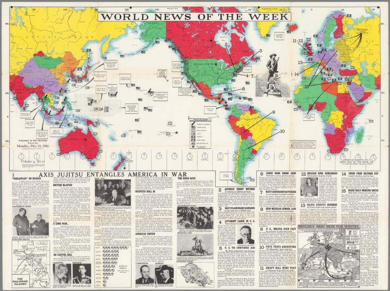
Author
News Map of the Week, Inc.
Full Title
World News of the Week : Monday, Dec. 15, 1941. Covering period Dec. 5 to Dec. 11. Volume 4, No. 15. Published and copyrighted (weekly), 1941, by News Map of the Week, Inc., 1512 Orleans Street, Chicago, Illinois. Published in two sections : Section one. Lithographed in U. S. A.
List No
14082.000
Note
Lithographed world map, in color. Shows political boundaries and military events of World War II, from December 5 to 11, 1941. Relief illustrated with hachures. Includes a legend indicating national sovereignty, including colonies. Descriptive text throughout, e.g.: Route over which Mexican forces will travel to Lower California. Map indexed according to historical notes beneath map. Features photographs, illustrations, and international time zones. With three inset maps: The Philippine Islands -- Japanese target -- Hitler's Best bets for winter. Also, with diagram: Aliens in America. Map is 56 x 115 cm, on sheet 89 x 120 cm, folded to 31 x 23 cm.
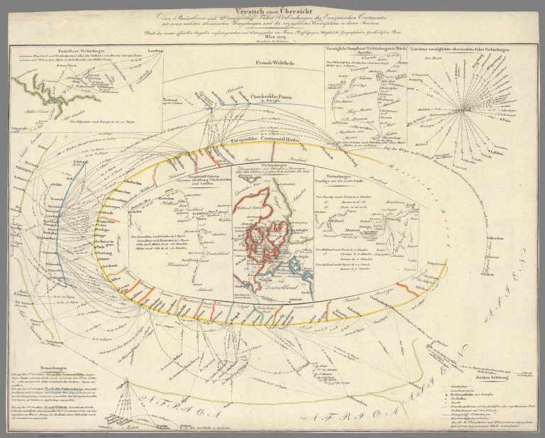
Author
Raffelsperger, Franz, 1793-1861
Full Title
Versuch einer Übersicht der Packetboot- und Dampfschiff-Fahrt-Verbindungen des Europäischen Continentes mit seinen nächsten überseeischen Umgebungen und der vorzüglichsten Wasserfahrten in dessen Innerem. Nach den neuesten officiellen Angaben verfasst, gezeichnet und herausgegeben von Franz Raffelsperger, Mitglied der Geographischen Gesellschaft in Paris. Wien 1829. Eigenthum des Verfassers. [Attempt at an Overview of Packet Boat and Steamship Connections between Europe and Overseas Ports as well as the Best Navigable Routes within the Interior. After the Latest Official Information, Authored, Drawn and Edited by Franz Raffelsperger, Member of the Geographical Society of Paris. Vienna 1829. Author’s rights reserved].
List No
10504.000
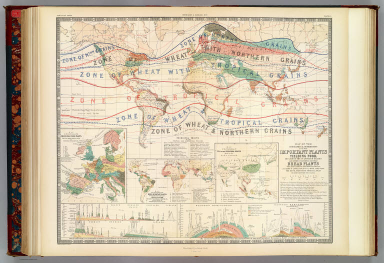
Author
[Henfrey, Arthur, 1819-1859, Johnston, Alexander Keith, 1804-1871]
Full Title
Map of the geographical distribution of the most important plants yielding food, including the cultivated grains and other cultivated and wild bread plants with indications of the principal fruits; laid down in connection with climatal conditions for Keith Johnston's Physical atlas by Arthur Henfrey, F.R.S; F.L.S. &c. Engraved & printed in colours by W. & A.K. Johnston, Edinburgh. William Blackwood & Sons, Edinburgh & London. 1st. March 1854, (1856)
List No
0372.025
Note
Col. lithographed map. Insets: Map of the distribution of the principal food plants, fruits & characteristic trees of Western & Central Europe -- Map of the distribution of the more important plants, yielding materials for beverages, spices, dyes, and other economical substances; and growing in the warmer regions of the globe -- Map of the distribution of tea & the principal spices grown in the East Indies -- Two sections from S. to N. in Western & Central Europe, showing the distribution of the principal food plants according to altitude -- Two sections showing approximatively the distribution of the most important economical plants according to altitude, Western Hemisphere, Eastern Hemisphere. "Phytology & zoology no. 1."
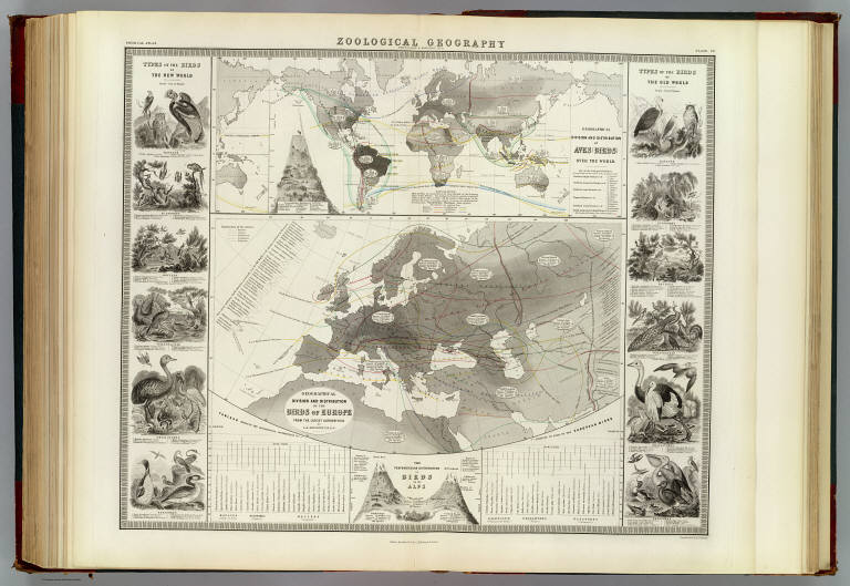
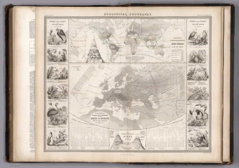
Author
Johnston, Alexander Keith, 1804-1871
Full Title
Zoological geography. Geographical division and distribution of the birds of Europe from the latest authorities by A.K. Johnston, F.R.G.S. Geographical division of Aves, birds, over the world. Engraved by W. & A.K. Johnston. William Blackwood & Sons, Edinburgh & London. (1856)
List No
0372.030
Note
Two hand col. lithographed maps on 1 sheet. Illustrations: Types of the birds of the New World -- Types of the birds of the Old World -- The perpendicular distribution of birds -- The perpendicular distribution of birds on the Alps. Chart: Tableau showing the geographical distribution in latitude of some of the European birds. "Phytology & zoology no. 6."
Author
Johnston, Alexander Keith, 1804-1871
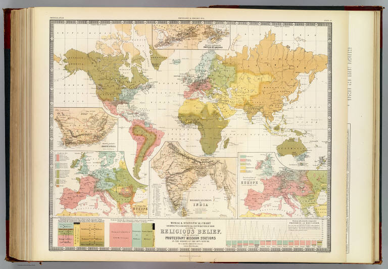
Full Title
Moral & statistical chart showing the geographical distribution of man according to religious belief, with the principal Protestant mission stations in the middle of the 19th century. By A. Keith Johnston, F.R.S.E. Engraved & printed in colours by W. & A.K. Johnston, Edinburgh. William Blackwood & Sons, Edinburgh & London. 1st May, 1854. (1856)
List No
0372.035
Note
Col. lithographed map. Inset maps: Distribution of man in Europe according to language. Scale [ca. 1:17,000,000] -- Mission stations of India. Scale [ca. 1:20,500,000] -- Prevailing forms of religion in Europe. Scale [ca. 1:17,000,000] -- Mission stations of British Nth. America -- Missions stations of South Africa. Includes statistical charts of population by religion and school enrollment. "Phytology & zoology no. 11."
Full Title
Isothermal and winds chart of the World. Religions of Europe. (Published at the office of "The Times," London, 1895)
List No
1010.007
Note
Two color maps.
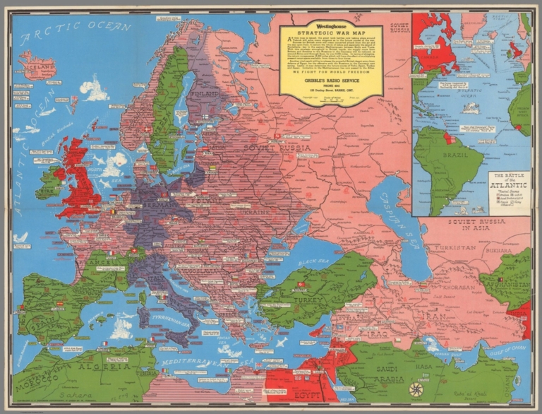
Author
[Turner, Stanley F., Canadian Westinghouse Company]
Full Title
Westinghouse strategic war map. Gribble's Radio Service ... Barrie, Ont. Copyright 1941. Stanley Turner. Copyright C.C. Petersen Advertising, 57 Queen St. W. Toronton. (inset) The battle of Atlantic. (on verso) Westinghouse strategic war map of the Pacific.
List No
11128.002
Note
Color map 50x66, folded into 25.5x17. Includes text and historical notes. Shows British, American, Russian, and Japanese air and naval bases. place names, oil fields, mines, and agricultural products. On verso: cover title "We fight for freedom" and uncolored map "Westinghouse strategic war map of the Pacific" Canadian Westinghouse Company, Limited. Relief shown pictorially.
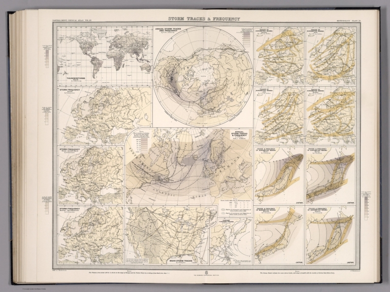
Bartholomew, J.G.; Knipping, E.; van Beb... Plate 28. Storm Tracks & Frequency. 1898 12430.038 Related Author
[Bartholomew, J.G., Knipping, E., van Bebber, J.W., Koeppen, W., Dunwoody, H.H.C.]
Full Title
Plate 28. Storm Tracks & Frequency.
List No
12430.038
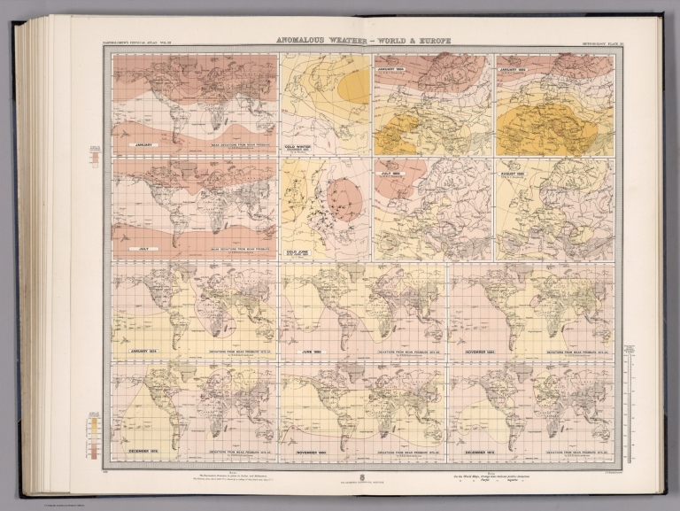
Bartholomew, J.G.; Herbertson, A.J.; Buc... Plate 30. Anomalous Weather - World & Eu... 1898 12430.040 Related Author
[Bartholomew, J.G., Herbertson, A.J., Buchan, Alexander]
Full Title
Plate 30. Anomalous Weather - World & Europe.
List No
12430.040
Johnston, Alexander Keith, 1804-1871 Zoological Geography. Aves (Birds) over ... 1850 12509.101 Related Author
Johnston, Alexander Keith, 1804-1871
Full Title
Zoological Geography. Aves (Birds) over the World. Birds of Europe. (insets) (Latitudes Distribution of Some European Birds). (Illustrations of Birds from the New World and from the Old World).
List No
12509.101
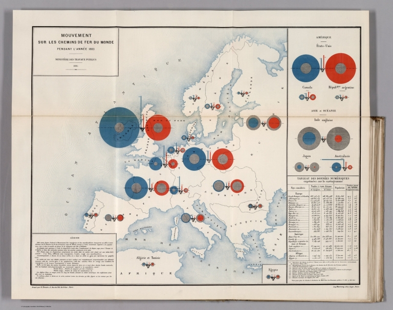
Ministere des Travaux Publics; Cheysson,... Mouvement Sur les Chemins de Fer du Mond... 1886 12516.014 Related Author
[Ministere des Travaux Publics, Cheysson, Émile]
Full Title
Mouvement Sur les Chemins de Fer du Monde Pendant L'Annee 1883. (Movement on the railroads of the world in 1883.)
List No
12516.014
Note
Graph type: concentric circle.
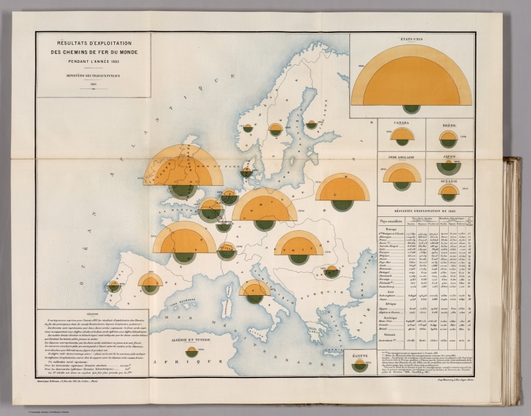
Ministere des Travaux Publics; Cheysson,... Resultats D'Exploitation des Chemins de ... 1886 12516.017 Related Author
[Ministere des Travaux Publics, Cheysson, Émile]
Full Title
Resultats D'Exploitation des Chemins de Fer du Monde Pendant L'Annee 1883. (Turnover of the railroads of the world in 1883.)
List No
12516.017
Note
Graph type: divided concentric circle.
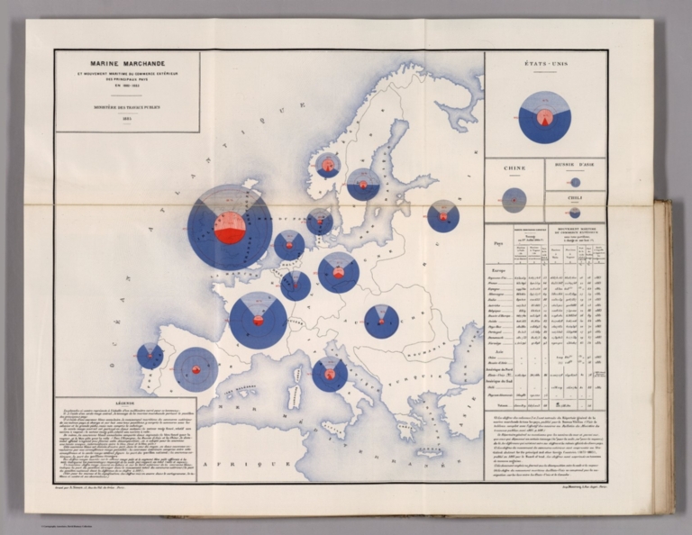
Ministere des Travaux Publics; Cheysson,... Marine Marchande et Mouvement Maritime d... 1886 12516.026 Related Author
[Ministere des Travaux Publics, Cheysson, Émile]
Full Title
Marine Marchande et Mouvement Maritime du Commerce Exterieur des Principaux Pays en 1882-1883. (Merchant navy and maritime movement of the trade exterior of the principal countries in 1883.)
List No
12516.026
Note
Graph type: flow.
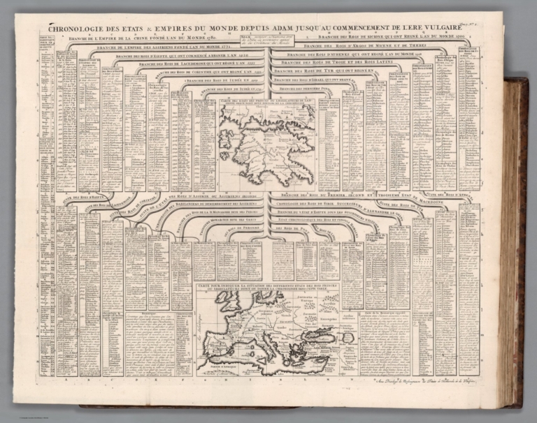
Chatelain Henri, 1684-1743; Gueudeville,... Tome 7. No. 2. Chronologie des Etats & E... 1720 13272.767 Related Author
[Chatelain Henri, 1684-1743, Gueudeville, Nicolas]
Full Title
Chronologie des Etats & Empires du Monde depuis Adam jusqu'au au Commencement de l'Ere Vulgaire ... Tom. 7. No. 2. (to accompany) Atlas Historique ... A Amsterdam, chez L'Honore & Chatelain Libraires. M DCC XX (1720).
List No
13272.767
Note
Two engraved maps on folded sheet: Carte Des Etats Des Princes Ou Legislateurs De Lancienne Grece Dont Nous Donnons Ici La Chronologie. Carte Pour Indiquer La Situation Des Differents Etats Des Rois Princes Ou Legislateurs Dont On Donne La Chronologie Dans Cette Table. With chronological chart of the various empire of ancient Europe. Maps showing towns, landmarks, rivers and mountains. Relief shown pictorially.
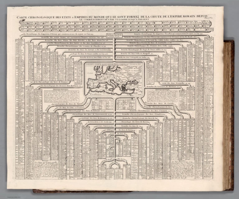
Chatelain Henri, 1684-1743; Gueudeville,... Tome 7. No. 2. Carte chronologique des e... 1720 13272.768 Related Author
[Chatelain Henri, 1684-1743, Gueudeville, Nicolas]
Full Title
Carte chronologique des etats et empires du monde, qui se sont former de la chute de l'empire romain, depuis le commencement de le ere vulgaire, jusqu'a present. Tom. 7. No. 3. (to accompany) Atlas Historique ... A Amsterdam, chez L'Honore & Chatelain Libraires. M DCC XX (1720).
List No
13272.768
Note
Engraved map of Europe at center on folded sheet, titled: Carte Pour Indiquer la Situation des Etats & Empires des Empereurs Rois & Princes Mentionnez dans cette Carte. With chronological chart tracing the ancestry of the royal houses of Europe. Map shows boundaries, towns, rivers and forests.
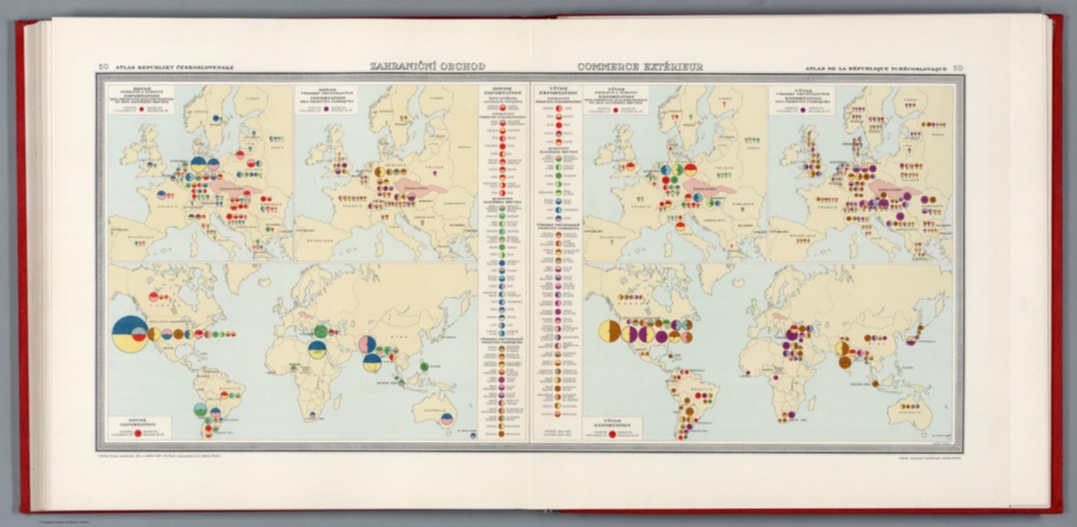
Pantoflíček, Jaroslav; Česká akademie ... Zahranicni obchod = Commerce extérieur 1931 13678.056 Related Author
[Pantoflíček, Jaroslav, Česká akademie věd a umění.]
Full Title
Zahranicni obchod = Commerce extérieur. Josef Ryba. 50. Atlas Republiky Československé = Atlas de la Republique Tchecoslovaque. Vydala Ceska akademie ved a umeni -1931- Editeur Nakladatelstvi Orbis, Praha : Tiskne Vojenskyì zeměpisnyì uìstav.
List No
13678.056
Note
2 trade maps of the world, with 4 insets on 2 sheets. Showing import and export of goods 1925-1928. Insets showing import and export of food and manufacture products. Includes legend.
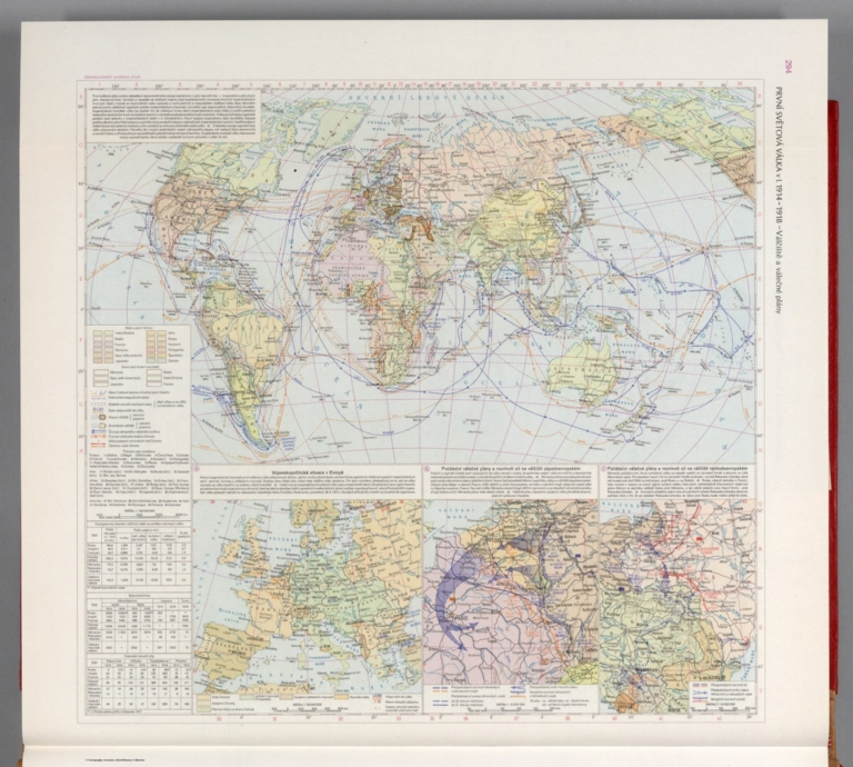
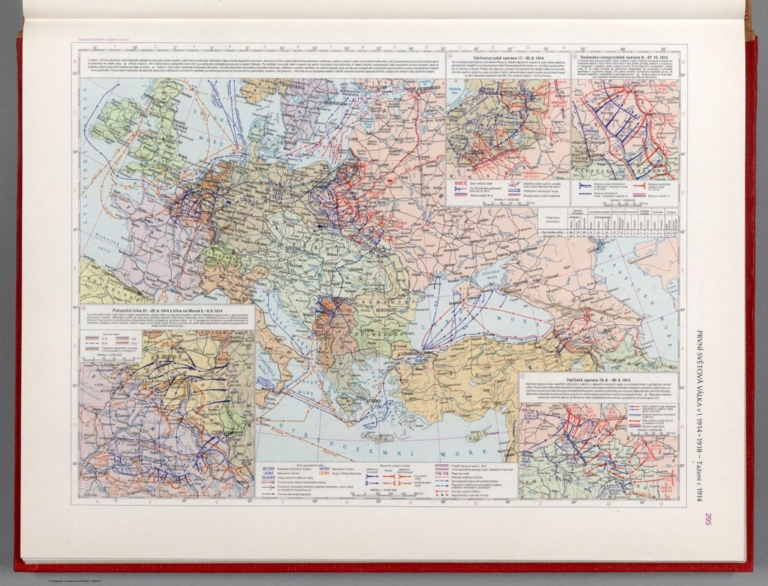
Československá akademie věd.; Klíma,... První Svétová válka v I. 1914-1918 - Vál... 1965 13684.225 Related Author
[Československá akademie věd., Klíma, Jan]
Full Title
První Svétová válka v I. 1914-1918 - Válčíště a válečné plány. Československý vojenský atlas.
List No
13684.225
Note
Timeline folded map of the world, with 3 inset maps, table, text and legends, on 1 sheet. Showing the first World War in 1914-1918, including warships and war plans of world war I.
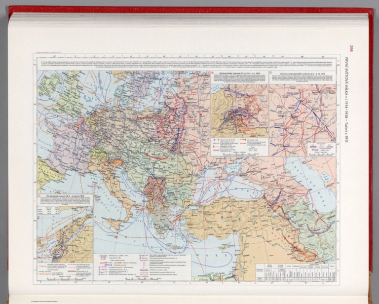
Československá akademie věd.; Klíma,... První Svétová válka v I. 1914=1918 - Taž... 1965 13684.226 Related Author
[Československá akademie věd., Klíma, Jan]
Full Title
První Svétová válka v I. 1914-1918 - Tažení r. 1914. Československý vojenský atlas.
List No
13684.226
Note
Timeline map of the world, with 4 inset maps, table, text and legends, on 1 sheet. Showing the first World War in 1914-1918, and Campaign of 1914.
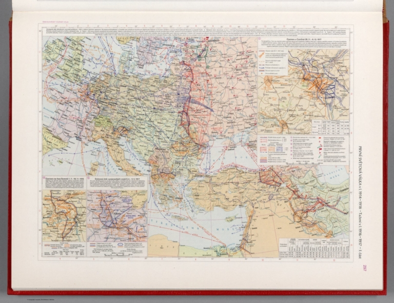
Československá akademie věd.; Klíma,... První Svétová válka v I. 1914=1918 - Taž... 1965 13684.227 Related Author
[Československá akademie věd., Klíma, Jan]
Full Title
První Svétová válka v I. 1914-1918 - Tažení r. 1915. Československý vojenský atlas.
List No
13684.227
Note
Timeline map of the world, with 3 inset maps, table, text and legends, on 1 sheet. Showing the first World War in 1914-1918, and Campaign of 1915.
Československá akademie věd.; Klíma,... První Svétová válka v I. 1914=1918 - Taž... 1965 13684.228 Related Author
[Československá akademie věd., Klíma, Jan]
Full Title
První Svétová válka v I. 1914-1918 - Tažení v I. 1916-1917 - I. část. Československý vojenský atlas.
List No
13684.228
Note
Timeline map of the world, with 3 inset maps, table, text and legends, on 1 sheet. Showing the first World War in 1914-1918, and Part 1: Campaign of 1916-1917.
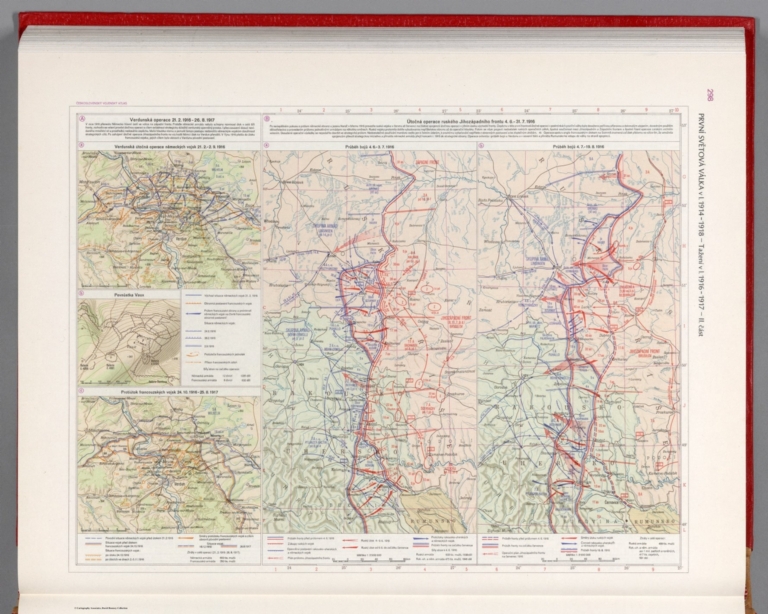
Československá akademie věd.; Klíma,... První Svétová válka v I. 1914=1918 - Taž... 1965 13684.229 Related Author
[Československá akademie věd., Klíma, Jan]
Full Title
První Svétová válka v I. 1914-1918 - Tažení v I. 1916-1917 - II. část. Československý vojenský atlas.
List No
13684.229
Note
2 Timeline maps, with 3 inset maps, text and legends, on 1 sheet. Showing the first World War in 1914-1918, and Part 2: Campaign of 1916-1917: Verdun operation and Russian offensive operation.
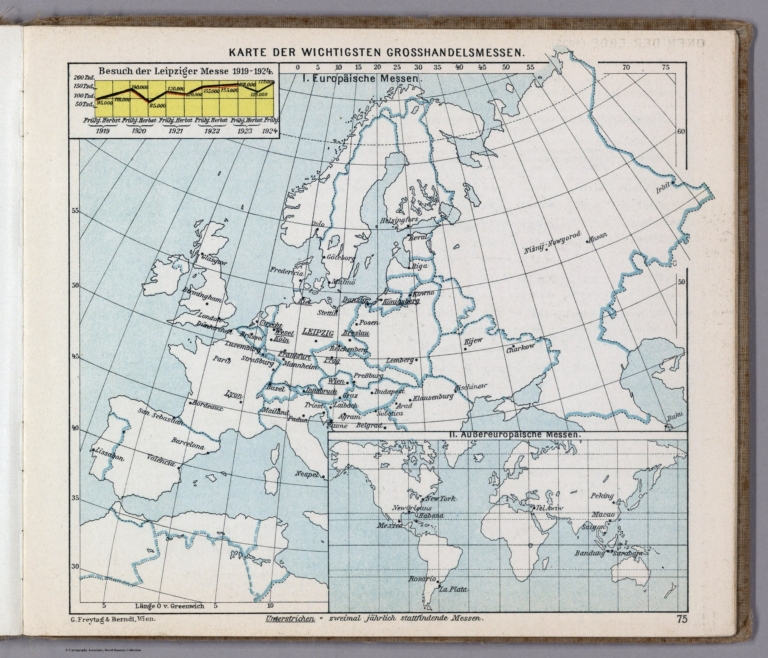
Hickmann, Anton Leo, 1834-1906; Fischer,... Karte der wichtigsten grosshandlesmessen 1927 13687.067 Related Author
[Hickmann, Anton Leo, 1834-1906, Fischer, Alois, b. 1894]
Full Title
Karte der wichtigsten grosshandlesmessen. G. Freytag & Berndt A.G., Wien. (to accompany) Prof. Hickmann's Geographisch-statistischer universal-atlas, 1927.
List No
13687.067
Note
Map of the major wholesale trades in Europe, with inset map of trades in non European countries and table of Leipzig trade fair, 1919-24.
Author
Cassini, Gio. Ma. (Giovanni Maria), 1745-approximately 1824
Full Title
(7) Globo terrestre delineato sulle ultime osservazioni con i viaggi e nuove scoperte del Cap. Cook Inglese. In Roma, presso la Calcografa. Camle. 1790. Gio. Ma. Cassini C. R. S. inc.
List No
14000.029
Note
Sheet 1 of 4-sheet map (in order of appearance). Globe gores in sheet 1 depict Africa, Europe and part of Asia. Relief shown pictorially. Includes decorative title cartouche. The contemporary discoveries in the Pacific Ocean are shown in great detail with delineation of Cook's 1768-1780 voyages. In Volume I.
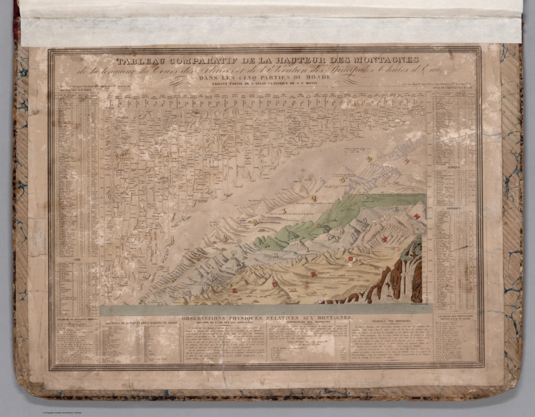
Andriveau-Goujon, E. (Eugène), 1832-1897 Tableau comparatif de la hauteur des mon... 1881 14008.002 Related Author
Andriveau-Goujon, E. (Eugène), 1832-1897
Full Title
Tableau comparatif de la hauteur des montagnes de la longueur du cours des fleures et de l'elevation des principales chûtes d'eau dans les cinq parties di monde faisant partie de l'atlas classique de C. V. Monin.
List No
14008.002
Note
Hand-colored, engraved diagram showing the comparative heights of mountains, lengths of rivers and heights of waterfalls in Europe, Asia, Africa and America. Includes index to mountains in left and right margins (with data and geographic locations), as well as descriptive text below: Observations physiques relatives aux montagnes. Diagram pasted onto verso of front cover, over marbled paper.
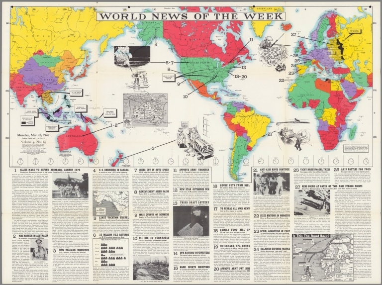
Author
News Map of the Week, Inc.
Full Title
World News of the Week : Monday, Mar. 23, 1942. Covering period Mar. 13 to Mar. 19. Volume 4, No. 29. Published and copyrighted (weekly), 1942, by News Map of the Week, Inc., 1512 Orleans Street, Chicago, Illinois. Published in two sections : Section one. Lithographed in U. S. A.
List No
14091.000
Note
Lithographed world map, in color. Shows political boundaries and military events of World War II, from March 13 to 19, 1942. Relief illustrated with hachures. Descriptive text throughout, e.g.: Captured by Russians. Map indexed according to historical notes beneath map. Features photographs, illustrations, and international time zones. With two inset maps: Australia -- Is this the road back? Also, with diagram: The world's income tax. Map is 56 x 115 cm, on sheet 89 x 120 cm, folded to 31 x 23 cm.
Author
News Map of the Week, Inc.
Full Title
World News of the Week : Monday, Mar. 27, 1944. Covering period Mar. 17 to Mar. 23. Volume 6, No. 30. Published and copyrighted (weekly), 1944, by News Map of the Week, Inc., 1512 Orleans Street, Chicago, Illinois. Published in two sections : Section one. Lithographed in U. S. A.
List No
14165.000
Note
Lithographed world map, in color. Shows political boundaries and military events of World War II, from March 17 to 23, 1944. Relief illustrated with hachures. Descriptive text throughout, e.g.: Red drive into Rumania threatens all Balkans. Map indexed according to historical notes beneath map. Features photographs, illustrations, and international time zones. With four inset maps: Hukawng Valley -- Mili -- (Cassino) -- Russia's drive into Rumania. Map is 56 x 115 cm, on sheet 89 x 120 cm, folded to 31 x 23 cm.
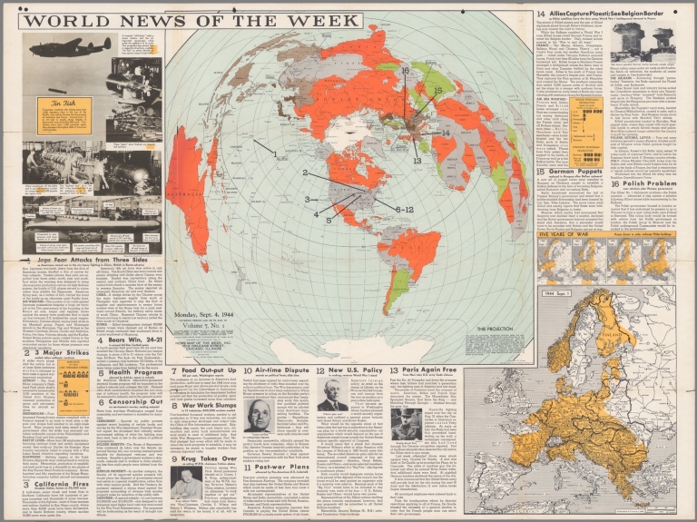
Bauer, Hubert A. (Hubert Anton), 1886-; ... World News of the Week : Monday, Sept. 4... 1944 14176.000 Related Author
[Bauer, Hubert A. (Hubert Anton), 1886-, American Airlines Inc., Carl Byoir & Associates, News Map of the Week, Inc.]
Full Title
World News of the Week : Monday, Sept. 4, 1944. Covering period Aug. 25 to Aug 31. Volume 7, No. 1. Published and copyrighted (weekly), 1944, by News Map of the Week, Inc., 1512 Orleans Street, Chicago, Illinois. Published in three sections : Section one. Cartographer, H. A. Bauer. Base map copyrighted by American Airlines, Inc. Photos from Amertrop by Carl Byoir and Associates.
List No
14176.000
Note
Lithographed world map, in color. Shows political boundaries and military events of World War II, from August 25 to 31, 1944. Relief illustrated with hachures. "This map - an azimuthal projection focused upon the geographical center of the United States - was developed by air-age education research of American Airlines, Inc." Descriptive text throughout, e.g.: France air, sea war. Map indexed according to historical notes in margins surrounding map. Features photographs. With five inset maps (all boundaries as of January 1, 1938): Five years of war : 1940 Sept. 1 -- 1941 Sept. 1 -- 1942 Sept. 1 -- 1943 Sept. 1 -- 1944 Sept. 1. Also, with two diagrams: Man-days of labor lost through strikes -- World petroleum production; Synthetic petroleum production. Map is 61 x 64 cm, on sheet 89 x 120 cm, folded to 31 x 23 cm.
Author
News Map of the Week, Inc.
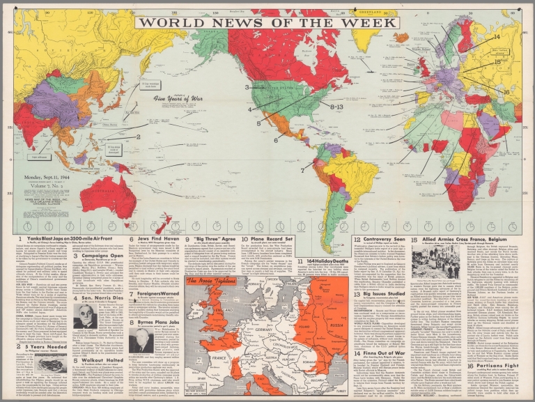
Full Title
World News of the Week : Monday, Sept. 11, 1944. Covering period Sept. 1 to Sept. 7. Volume 7, No. 2. Published and copyrighted (weekly), 1944, by News Map of the Week, Inc., 1512 Orleans Street, Chicago, Illinois. Published in two sections : Section one. Lithographed in U. S. A.
List No
14178.000
Note
Lithographed world map, in color. Shows political boundaries and military events of World War II, from September 1 to 7, 1944. Relief illustrated with hachures. Includes a chronology: Highlights of five years of war. Descriptive text throughout, e.g.: Allies land in North Africa. Map indexed according to historical notes beneath map. Features photographs, illustrations, and international time zones. With inset map: The noose tightens. Map is 56 x 115 cm, on sheet 89 x 120 cm, folded to 31 x 23 cm.
Author
News Map of the Week, Inc.
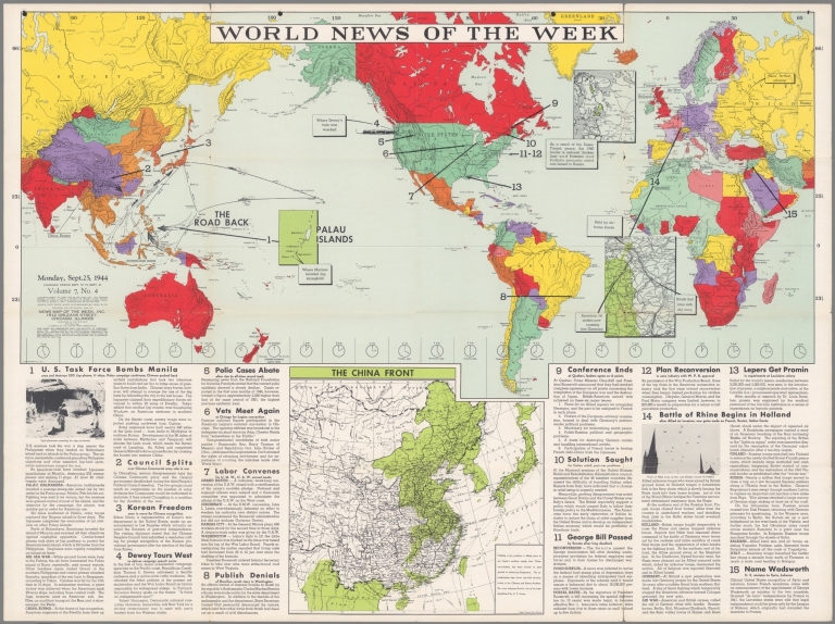
Full Title
World News of the Week : Monday, Sept. 25, 1944. Covering period Sept. 15 to Sept. 21. Volume 7, No. 4. Published and copyrighted (weekly), 1944, by News Map of the Week, Inc., 1512 Orleans Street, Chicago, Illinois. Published in two sections : Section one. Lithographed in U. S. A.
List No
14179.000
Note
Lithographed world map, in color. Shows political boundaries and military events of World War II, from Sept. 15 to 21, 1944. Relief illustrated with hachures. Descriptive text throughout, e.g.: British 2nd joins with sky army. Map indexed according to historical notes beneath map. Features photographs, illustrations, and international time zones. With four inset maps: Palau Islands -- (Finland) -- (Border between Belgium and Germany) -- The China front. Map is 56 x 115 cm, on sheet 89 x 120 cm, folded to 31 x 23 cm.
Denoyer-Geppert Company; News Map of the... World News of the Week : Monday, Oct. 10... 1949 14193.000 Related Author
[Denoyer-Geppert Company, News Map of the Week, Inc.]
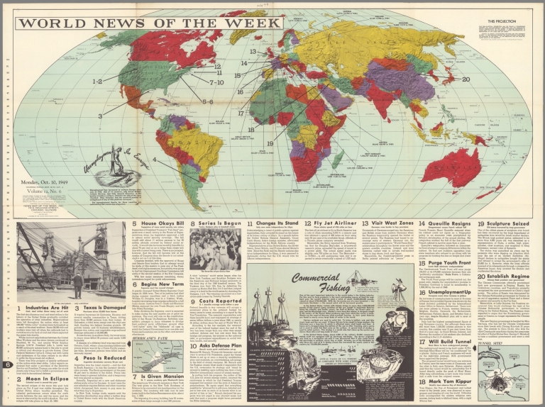
Full Title
World News of the Week : Monday, Oct. 10, 1949. Covering period Sept. 30 to Oct. 6. Volume 12, No. 6. Published and copyrighted (weekly), 1949, by News Map of the Week, Inc., 1512 Orleans Street, Chicago, Illinois. Published in two sections : Section one. Lithographed in U. S. A. Semi-elliptical map projection used by permission of Denoyer-Geppert Company.
List No
14193.000
Note
Lithographed world map, in color. Shows political boundaries and significant events from September 30 to October 6, 1949. Relief illustrated with hachures. "This semi-elliptical projection may be termed a compromise between the two-dimensional Mercator and the three-dimensional presentation of the globe. It reduces distortion in areas near the pole and maintains a close approximation of proportion in the land and sea areas ... " Includes statistics on unemployment in Europe, as compared to 1948, with explanatory text. Map indexed according to historical notes beneath map. With two inset maps: Hurricane's path -- Tunnel site? Also, with diagram: Commercial fishing. Map is 47 x 115 cm, on sheet 89 x 120 cm, folded to 31 x 23 cm.
Denoyer-Geppert Company; News Map of the... World News of the Week : Monday, Jan. 29... 1951 14221.000 Related Author
[Denoyer-Geppert Company, News Map of the Week, Inc.]
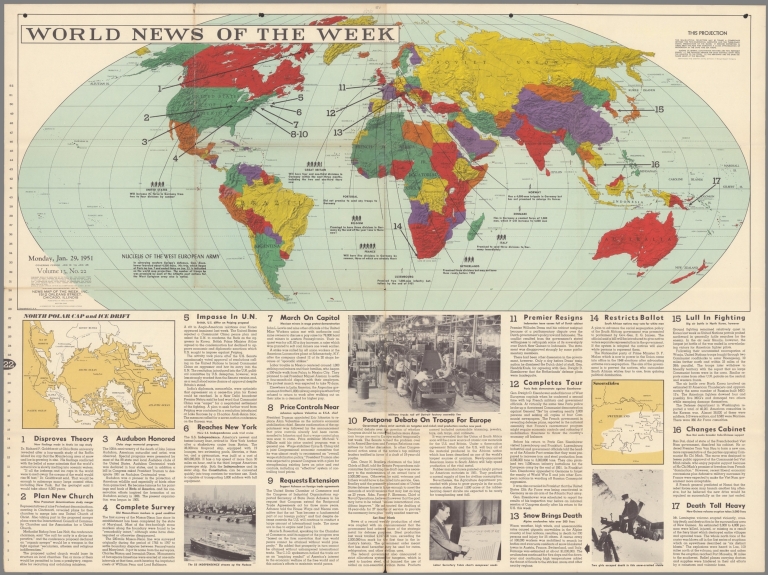
Full Title
World News of the Week : Monday, Jan. 29, 1951. Covering period Jan. 19 to Jan. 25. Volume 13, No. 22. Published and copyrighted (weekly), 1951, by News Map of the Week, Inc., 1512 Orleans Street, Chicago, Illinois. Published in two sections : Section one. Lithographed in U. S. A. Semi-elliptical map projection used by permission of Denoyer-Geppert Company.
List No
14221.000
Note
Lithographed world map, in color. Shows political boundaries and significant events from January 19 to 25, 1951. Relief illustrated with hachures. "This semi-elliptical projection may be termed a compromise between the two-dimensional Mercator and the three-dimensional presentation of the globe. It reduces distortion in areas near the pole and maintains a close approximation of proportion in the land and sea areas ... " Includes information on "Nucleus of the West European Army," with explanation, as well as descriptive text throughout, e.g.: Portugal : Did not promise to send any troops to Germany. Map indexed according to historical notes beneath map. With two inset maps: North polar cap and ice drift -- Snowslides. Map is 47 x 115 cm, on sheet 89 x 120 cm, folded to 31 x 23 cm.
Author
[Imhof, Eduard, 1895-1986, Eidgenössische Landestopographie, Jaccard, Maurice, Imhof, Eduard, Roth-Kim, Jörg]
Full Title
Auslandschweizer = Suisses de l'etranger : Auslandschweizer. Europäische Gebiete = Suisses de létranger. Pays européens -- Auslandschweizer. Aussereuropäische Gebiete = Suisses de létranger. Régions d'outre-mer. Bearbeiter... : Maurice Jaccard, Eduard Imhof, Jörg Roth-Kim, Zürich. Kartographische Gestaltung ... : Redaktion Atlas der Schweiz, Eidgenössischen Technische Hochschule, Zürich ... © Atlas der Schweiz. Eidg. Landestopographie, Wabern-Bern, 1968 ...
List No
14256.135
Note
Two colored emigration maps of Europe and the world, numbered 34 within Atlas der Schweiz. On second and third pages of thirty-fourth (numbered) folio. Title - in German and French - translates to: [Swiss Abroad : Swiss Abroad : European territories -- Swiss abroad : Outside of Europe]. Maps show international political borders, routes of emigration (with distances), and the numbers of Swiss citizens who live outside of Switzerland, in Europe and the wider world. Includes latitudinal and longitudinal lines, a legend and explanatory notes, as well as scale and projection statements. World map indexed. Together, maps are 62 x 45 cm, on sheet 76 x 51 cm. "34" in upper left and right corners. Accompanied by descriptive text on first and fourth pages of folio.
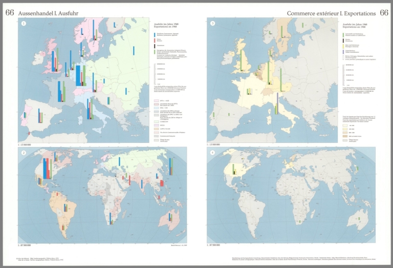
Author
[Imhof, Eduard, 1895-1986, Eidgenössische Landestopographie, Zumbrunn, Armin]
Full Title
Aussenhandel I. Ausfuhr = Commerce extérieur I. Exportations : Ausfuhr im Jahre 1968 = Exportations en 1968 : 1 -- 2 -- 3 -- 4. Bearbeitung und kartographische Gestaltung: Eduard Imhof, Redaktion des Atlas der Schweiz, Eidgenössischen Technische Hochschule, Zürich. Statistische Daten: Eidg. Oberzolldirektion, Abteilung Handelsstatistik, Bern ... © Atlas der Schweiz. Eidg. Landestopographie, Wabern-Bern, 1970 ...
List No
14256.244
Note
Four colored trade maps of Europe and the world, numbered 66 within Atlas der Schweiz. On second and third pages of sixty-sixth (numbered) folio. Titles - in German and French - translate to: [Foreign trade I. Export : Export in 1968 : 1 -- 2 -- 3 -- 4]. Maps show international political borders, seas and large lakes, as well as exports from Switzerland to Europe and the wider world. Includes legends, explanatory notes and scale statements for differing scales. Maps indexed to indicate country names (directory on fourth page). Together, maps are 44 x 70 cm, on sheet 52 x 76 cm. "66" in upper left and right corners. Related diagram follows on subsequent page. Accompanied by descriptive text on first page of folio. First folio in a series of four showing foreign trade (folios 66-69).
Author
[Imhof, Eduard, 1895-1986, Eidgenössische Landestopographie, Zumbrunn, Armin]
Full Title
Aussenhandel I = Commerce extérieur I = Commercio estero I : Verzeichnis der Ländernamen für die Tafeln 66-69 = Répertoire des noms de pays pour les planches 66-69 = Repertorio dei nomi dei paesi per le tavole 66-69 -- Anteil der wichtigsten Industrien an der Gesamtausfuhr 1906-1968 = Parts des principales industries aux exportations totales, 1906-1968 = Quote parti delle principali industrie rispetto all'esportazione complessiva, 1906-1968.
List No
14256.245
Note
Colored trade diagram of Europe and the world, numbered 66 within Atlas der Schweiz, as well as a directory to country names in indexed maps throughout folios 66-69. On fourth page - back cover - of sixty-sixth (numbered) folio. Titles - in German, French and Italian - translate to: [Foreign trade I. List of country names for folios 66-69 -- Share of the most important industries in total exports, 1906-1968]. Includes a legend. Diagram is 13 x 33 cm, on sheet 52 x 38 cm. With bibliographic citations at bottom of sheet. "66" in upper left corner. Four related maps on second and third pages of folio. Accompanied by descriptive text on first page. First folio in a series of four showing foreign trade (folios 66-69).
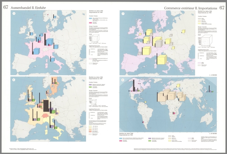
Author
[Imhof, Eduard, 1895-1986, Eidgenössische Landestopographie, Zumbrunn, Armin]
Full Title
Aussenhandel II : Einfuhr = Commerce extérieur II : Importations : Einfuhr im Jahre 1968 = Importations en 1968 : 5 -- 6 -- 7 -- 8. Bearbeitung und kartographische Gestaltung: Eduard Imhof, Redaktion des Atlas der Schweiz, Eidgenössischen Technische Hochschule, Zürich. Statistische Daten: Eidg. Oberzolldirektion, Abteilung Handelsstatistik, Bern ... © Atlas der Schweiz. Eidg. Landestopographie, Wabern-Bern, 1970 ...
List No
14256.247
Note
Four colored trade maps of Europe and the world, numbered 67 within Atlas der Schweiz. On second and third pages of sixty-seventh (numbered) folio. Titles - in German and French - translate to: [Foreign trade II. Imports : Imports in 1968 : 5 -- 6 -- 7 -- 8]. Maps show international political borders, seas and large lakes, as well as imports from Europe and the wider world into Switzerland. Includes legends, explanatory notes and scale statements for differing scales. Maps indexed to indicate country names (directory On fourth page - back cover - of folio 66). Together, maps are 45 x 70 cm, on sheet 52 x 76 cm. "67" in upper left and right corners. Related table, map and diagram follow on subsequent page. Accompanied by descriptive text on first page of folio. Second folio in a series of four showing foreign trade (folios 66-69).
Author
[Imhof, Eduard, 1895-1986, Eidgenössische Landestopographie, Zumbrunn, Armin]
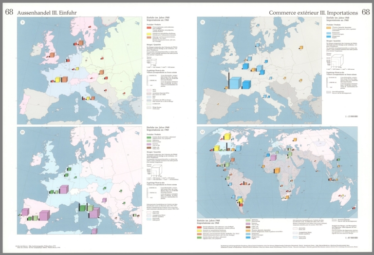
Full Title
Aussenhandel III. Einfuhr = Commerce extérieur III. Importations : Einfuhr im Jahre 1968 = Importations en 1968 : 9 -- 10 -- 11 -- 12. Bearbeitung und kartographische Gestaltung: Eduard Imhof, Redaktion des Atlas der Schweiz, Eidgenössischen Technische Hochschule, Zürich. Statistische Daten: Eidg. Oberzolldirektion, Abteilung Handelsstatistik, Bern ... © Atlas der Schweiz. Eidg. Landestopographie, Wabern-Bern, 1970 ...
List No
14256.250
Note
Four colored trade maps of Europe and the world, numbered 68 within Atlas der Schweiz. On second and third pages of sixty-eighth (numbered) folio. Titles - in German and French - translate to: [Foreign trade III. Imports : Imports in 1968 : 9 -- 10 -- 11 -- 12]. Maps show international political borders, seas and large lakes, as well as imports from Europe and the wider world into Switzerland. Includes legends, explanatory notes and scale statements for differing scales. Maps indexed to indicate country names (directory On fourth page - back cover - of folio 66). Together, maps are 45 x 70 cm, on sheet 52 x 76 cm. "68" in upper left and right corners. Two related charts and map follow on subsequent page. Accompanied by descriptive text on first page of folio. Third folio in a series of four showing foreign trade (folios 66-69).
Author
[Imhof, Eduard, 1895-1986, Eidgenössische Landestopographie]
Full Title
Aussenhandel IV = Commerce extérieur IV = Commercio estero IV : Bezeichnungen der auf den Tafeln 66-69 dargestellten multilateralen Abkommen für wirtschaftliche Zusammenarbeit (Abkürzungen und Volltexte) = Désignations des accords multilatéraux de coopération économique, figurant sur les planches 66-69 (abbréviations et rédaction complète) = Denominazione degli accordi multilaterali di cooperazione economica, presentati nelle tavole 66-69 (abbreviazioni e denominazioni complete) -- Die EWG und ihre Assoziierten = La CEE et ses associés = La CEE e i suoi associati : Stand = Situation au - Al : 1. 10. 1969.
List No
14256.252
Note
Statistical table and colored trade map of Switzerland, Europe and the world, numbered 69 within Atlas der Schweiz, in German, French and Italian. On first page - front cover - of sixty-ninth (numbered) folio. Titles translate to: [Foreign trade IV : Names of the multilateral agreements for economic cooperation shown on folios 66-69 (abbreviations and full texts) -- The EEC and its associates : October 1, 1969.]. Titles of subsequent maps and diagrams listed beneath folio title. Map shows international political borders, seas and large lakes, as well as Swiss trade agreements with Europe and the wider world. Includes a legends explanatory notes and a scale statement. Map indexed to indicate country names (directory On fourth page - back cover - of folio 66). Map is 16 x 18 cm, on sheet 52 x 76 cm. "69" in upper right corner. Four related maps and four diagrams follow on subsequent pages. Fourth folio in a series of four showing foreign trade (folios 66-69).
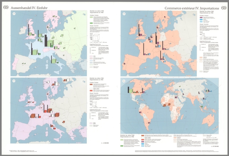
Author
[Imhof, Eduard, 1895-1986, Eidgenössische Landestopographie]
Full Title
Aussenhandel IV. Einfuhr = Commerce extérieur IV. Importations : Einfuhr im Jahre 1968 = Importations en 1968 : 13 -- 14 -- 15 -- 16. Bearbeitung und kartographische Gestaltung: Eduard Imhof, Redaktion des Atlas der Schweiz, Eidgenössischen Technische Hochschule, Zürich. Statistische Daten: Eidg. Oberzolldirektion, Abteilung Handelsstatistik, Bern ... © Atlas der Schweiz. Eidg. Landestopographie, Wabern-Bern, 1970 ...
List No
14256.253
Note
Four colored trade maps of Europe and the world, numbered 69 within Atlas der Schweiz. On second and third pages of sixty-ninth (numbered) folio. Titles - in German and French - translate to: [Foreign trade IV. Imports : Imports in 1968 : 13 -- 14 -- 15 -- 16]. Maps show international political borders, seas and large lakes, as well as imports from Europe and the wider world into Switzerland. Includes legends, explanatory notes and scale statements for differing scales. Maps indexed to indicate country names (directory On fourth page - back cover - of folio 66). Together, maps are 45 x 70 cm, on sheet 52 x 76 cm. "69" in upper left and right corners. Related table and map on first page; four related diagrams follow on subsequent page. Fourth folio in a series of four showing foreign trade (folios 66-69).
Full Title
Isothermen- und Windkatre (i.e. Windkarte) der Erde. Religionskarte von Europa. (Richard Andree. Herausgegeben von der Geographischen Anstalt von Velhagen & Klasing in Leipzig. 1881)
List No
1494.015
Note
Two colored maps. Prime meridian on Religionskarte von Europa: Ferro. "VII.1880."
|