|
Author
Marie-Davy, Hippolyte
Full Title
Planisphere chatelain ou carte des voies de communication Etablies dans le Monde entier au moyen de la Vapeur et de L'Electricite = World's steam and Electric map. Traces par Marié Davy, de l'Observatoire de Paris. Grave chez Erhard Schieble, Paris. Imp. Monrocq.
List No
13226.000
Note
Color steam and electric map of the world, on sheet 122 x 165, sectioned and backed with linen, folded into 21x21, with publisher's label pasted on cover. Includes 3 insets: Iles Britanique. Etats-Unis. Europe. First edition published in 1862. Map shows political boundaries, roads, railroads and shipping lines. Relief shown by hachures and form lines. Map includes countries' flags sprinkled throughout the map marking territories, color coded key to European possessions and notes. The legend also marks pathways of communication established by steam and those by electricity.
Author
Church Missionary Society.
Full Title
Map of the world : showing the prevailing religions 1862. (to accompany) The Church missionary atlas ... Third edition. London : Published for the Society, by Seeley, Jackson, and Halliday. 1862.
List No
13242.008
Note
Double hemisphere colored religion map shows the distribution of the world major religions,
Author
Faden, William, 1749-1836
Full Title
Orbis Veteribus Notus. Published by W. Faden. Jany 1, 1819. T.C. Conder, sculp. (to accompany) Atlas minimus universalis, or, A geographical abridgement ancient and modern of the several parts of the earth ... Second edition. Jan 1, 1821.
List No
13243.016
Note
Double page outline hand color engraved map. Show the Ancient World during the time of the Ancient Roman Empire, including Asia, Europe and Africa. Relief shown pictorially.
Author
[Lapie, Pierre, M. 1779-1850, Lapie, Alexandre Emile]
Full Title
Carte du Monde connu des anciens. Dressee par M. Lapie, Colonel d'Etat Major et M. Lapie fils, Capitaine au meme Corps. Paris 1851. Chez P. C. Lehuby. Grave par Pierre Tardieu. (to accompany) Atlas Universel de Geographie ancienne et moderne ...1851.
List No
13244.009
Note
Engraved map. Outline hand color. Relief shown by hachures. Includes diagram "Noms de vents chez les anciens." Prime meridian: Lutece. In upper left margin: Atlas universel.
Author
[Lapie, Pierre, M. 1779-1850, Lapie, Alexandre Emile]
Full Title
Mappe-monde sur la projection de Mercator. Dressee par M. Lapie, Colonel d'Etat Majr. et Mr. Lapie fils, Chef d'Escon. d'Etat Major. Paris,1851. Chez P. C. Lehuby. Grave par P. Tardieu. (to accompany) Atlas Universel de Geographie ancienne et moderne ...1851.
List No
13244.022
Note
Engraved map. Outline hand color. Relief shown by hachures. Prime meridian is Paris. In upper left margin: Atlas universel.
Author
[Lapie, Pierre, M. 1779-1850, Lapie, Alexandre Emile]
Full Title
Mappe-monde en deux hemispheres. Par M. Lapie, Colonel d'Etat Major et Mr. Lapie fils, Chef d'Escon. d'Etat Major. Paris,1851. Chez P. C. Lehuby. Grave par P. Tardieu. (to accompany) Atlas Universel de Geographie ancienne et moderne ...1851.
List No
13244.023
Note
Engraved double hemisphere maps. Outline hand color. Showing old hemisphere and new hemisphere. Relief shown by hachures. Prime meridian is Paris. In upper left margin: Atlas universel.
Author
[Berghaus, Heinrich, 1797-1884, Sohr, Karl, Flemming, Carl]
Full Title
Geog. verbreitung des Christlichen Staaten Systems auf der Ganzen Erde. Lith. Druck und Verlag von C. Flemming in Glogau. (to accompany) Vollstandiger Universal-Handatlas der neueren Erdbeschreibung ,,, Heinrich Berghaus ... 1859.
List No
13250.006
Note
Outline color map of the world showing spread of the Christian state system on the earth. Includes color coded keys to The American state system and European State system.
Author
Ensign, Bridgman & Fanning
Full Title
World at one view. Published by Ensign & Bridgman, 29 Beekman St., New York. Entered according to Act of Congress... 1854 by Ensign, Bridgman & Fanning ... New York."
List No
13265.000
Note
Date from Population of Principal Cities of the World chart showing United States cities as of 1860. This pictorial map gets larger with each issue: this 1860 printing is slightly larger than 1854 edition and is almost twice the size of the of the (1852) edition, showing the population growth in principal cities of the United States and Europe. Includes hand color circular maps of Western and Eastern Hemispheres, population tables, a large "Universal Dial Plate Or Times Of All Nations.", Principal rivers of the world, view of the mountain heights of the world, illustrations of nationality and race.
Author
[Chatelain Henri, 1684-1743, Gueudeville, Nicolas]
Full Title
(Contents to) Atlas Historique, Ou Nouvelle Introduction A l'Histoire, aÌ la Chronologie & aÌ la Geìographie Ancienne & Moderne : Repreìsenteìe dans de Nouvelles Cartes ... Par Mr. C., avec des dissertations sur l'histoire de chaque etat. Par Mr. Gueudeville ... Nouvelle edition reveue & corrogee : Tome I. Que comprend la GreÌce, l'Histoire Romaine, Rome Moderne, Naples, la France, l'Espagne, & les Provinces Unies. A Amsterdam, chez L'Honore & Chatelain. M DCC XVIII (1718).
List No
13272.008
Note
Continues:Table pour l'Ordres et l'arrangement de cet atlas.
Author
[Chatelain Henri, 1684-1743, Gueudeville, Nicolas]
Full Title
Mappe-monde pour connoitre les progres & les conquestes les plus remarquables des Prouinces-Unies : ainsy que celles des compagnies d'Orient et d'Occident, et les pais quelles possédent dans l'un et dans l'autre hemisphere. No. 46. (to accompany) Atlas Historique ... Tome I. A Amsterdam, chez L'Honore & Chatelain. M DCC XVIII (1718).
List No
13272.121
Note
Double hemisphere engraved map of the world, decorated with engraved illustrations. Shows California as an Island, incomplete Australia and New Zealand, west coast of America extends west toward Asia. Map depicts the expedition routes and lists colonial possessions. Includes descriptive text and tables.
Author
[Chatelain Henri, 1684-1743, Gueudeville, Nicolas]
Full Title
Chronologie des Etats & Empires du Monde depuis Adam jusqu'au au Commencement de l'Ere Vulgaire ... Tom. 7. No. 2. (to accompany) Atlas Historique ... A Amsterdam, chez L'Honore & Chatelain Libraires. M DCC XX (1720).
List No
13272.767
Note
Two engraved maps on folded sheet: Carte Des Etats Des Princes Ou Legislateurs De Lancienne Grece Dont Nous Donnons Ici La Chronologie. Carte Pour Indiquer La Situation Des Differents Etats Des Rois Princes Ou Legislateurs Dont On Donne La Chronologie Dans Cette Table. With chronological chart of the various empire of ancient Europe. Maps showing towns, landmarks, rivers and mountains. Relief shown pictorially.
Author
[Chatelain Henri, 1684-1743, Gueudeville, Nicolas]
Full Title
Carte chronologique des etats et empires du monde, qui se sont former de la chute de l'empire romain, depuis le commencement de le ere vulgaire, jusqu'a present. Tom. 7. No. 3. (to accompany) Atlas Historique ... A Amsterdam, chez L'Honore & Chatelain Libraires. M DCC XX (1720).
List No
13272.768
Note
Engraved map of Europe at center on folded sheet, titled: Carte Pour Indiquer la Situation des Etats & Empires des Empereurs Rois & Princes Mentionnez dans cette Carte. With chronological chart tracing the ancestry of the royal houses of Europe. Map shows boundaries, towns, rivers and forests.
Author
[Chatelain Henri, 1684-1743, Gueudeville, Nicolas]
Full Title
Carte du premier periode du Monde depuis Adam jusqua' a Moise ou l'on voit la Chronologie & la genealogie des premeirs patriarches avec des remarques pour conduire a l'intelligence de l'Histoire sacree. Premier periode du Monde depuis Adam jusqua' a Moise ou la loy ecrite. Tom. 7. No. 25. (to accompany) Atlas Historique ... A Amsterdam, chez L'Honore & Chatelain Libraires. M DCC XX (1720).
List No
13272.842
Note
Engraved map of first period of the World surrounded and keyed to a Biblical genealogical family tree from Adam to Moise. Panels at side provide an historical timeline for the history of the world before the birth of Christ.
Author
[Chatelain Henri, 1684-1743, Gueudeville, Nicolas]
Full Title
Carte pour conduire a l'intelligence de l'histoire sacree qui renferme en abrege la genealogie, la geographie et la chronologie de l'Histoire Sainte. Seconde periode du Monde depuis Moyse jusqu'au regne des Rois d'Israël et de Juda. Tom. 7. No. 26. (to accompany) Atlas Historique ... A Amsterdam, chez L'Honore & Chatelain Libraires. M DCC XX (1720).
List No
13272.843
Note
Engraved map of the second period of the world. Map titled: Carte De L'Introduction Du Peuple D'Israel, Dans Le Pais De Canaan Et le Païs qui echet par sert a chaque Tribu, with 3 insets. Map keyed to abbreviated genealogy, geography and chronological history of the Bible. Shows boundaries, towns, trails, compass rose and landmarks. Relief shown pictorially. Includes descriptive text.
Author
[Chatelain Henri, 1684-1743, Gueudeville, Nicolas]
Full Title
Suite de la genealogie ou chronologie des rois, patriarches et prophetes du troisieme periode du monde : Troisieme periode du monde depuis les rois Iusqu'A la captivite De Babilone. Tom. 7. No. 27. (to accompany) Atlas Historique ... A Amsterdam, chez L'Honore & Chatelain Libraires. M DCC XX (1720).
List No
13272.844
Note
Engraved map of the third period of the world. Map titled: Carte pour l'inteligence de histoire de rois d'Israel et de Juda, with inset. Includes abbreviated genealogy, geography and chronological history of the Bible. Shows boundaries, towns, trails, compass rose and landmarks. Relief shown pictorially. Includes descriptive text.
Author
[Chatelain Henri, 1684-1743, Gueudeville, Nicolas]
Full Title
Carte pour conduire a l'Inteligence de l'histoire sacree qui renferme en abrege la genealogie, la geographie et la chronologie de l'histoire Sainte. Quatrieme periode du monde depuis la captivite iusqu'a Jesus Christ.Tom. 7. No. 28. (to accompany) Atlas Historique ... A Amsterdam, chez L'Honore & Chatelain Libraires. M DCC XX (1720).
List No
13272.845
Note
Engraved map of the fourth period of history of the world. Map titled: Carte pour la Suite de l'Histoire des Rois et de la Captivité de Peuple d'Israel et de Juda, with 2 insets. Includes abbreviated genealogy, geography and chronological history of the Bible. Shows trails, compass rose and landmarks. Relief shown pictorially. Includes descriptive text.
Author
[Chatelain Henri, 1684-1743, Gueudeville, Nicolas]
Full Title
Abrege de l'histoire sacre du premiere age du monde. Abrege de l'histoire sacre du seconde age du monde . Abrege de l'histoire sacre du troisieme age du monde. Abrege de l'histoire sacre du quatrieme age du mondeTom. 7. No. 29. (to accompany) Atlas Historique ... A Amsterdam, chez L'Honore & Chatelain Libraires. M DCC XX (1720).
List No
13272.849
Note
Summary and data visualization of the sacred history of the world.
Author
[Chatelain Henri, 1684-1743, Gueudeville, Nicolas]
Full Title
Chronologie abregee de l'histoir sacree du cinquieme age du monde. Tom. 7. No.30. (to accompany) Atlas Historique ... A Amsterdam, chez L'Honore & Chatelain Libraires. M DCC XX (1720).
List No
13272.850
Note
Continuation of the summary and data visualization of the sacred history of the world.
Author
[Chatelain Henri, 1684-1743, Gueudeville, Nicolas]
Full Title
Abrege de l'histoirque du sixieme age du monde pour condilier la suite de l'histoire sacree. Abrege de l'histoirque du VII age du monde. Tom. 7. No. 31. (to accompany) Atlas Historique ... A Amsterdam, chez L'Honore & Chatelain Libraires. M DCC XX (1720).
List No
13272.851
Note
Continuation of the summary and data visualization of the sacred history of the world.
Author
[Chatelain Henri, 1684-1743, Gueudeville, Nicolas]
Full Title
Carte pour servir a l' eclaircissement des III. Carte des VII. Ages du monde de histoire sacree. Tom. 7. No. 32. (to accompany) Atlas Historique ... A Amsterdam, chez L'Honore & Chatelain Libraires. M DCC XX (1720).
List No
13272.852
Note
Data visualization and clarification of the sacred history of the world.
Author
[Meyer, Herrmann Julius, 1826-1909., Ravenstein, Ludwig]
Full Title
Erdkarte in Mercator Projection. L. Ravenstein dir. Corr. I. Stich. Druck u. Verlag des Bibliographischen Instituts zu Hildburghausen. Stich. v. E. Kuhn. (to accompany) Meyer's Hand-Atlas ... 1872.
List No
13324.014
Note
Outline hand colored map of the Earth in Mercator's Projection. Showing Ocean Currents and Wind. Telegraph cables shown in red lines and railways shown in black lines. Includes explanation. Relief shown by shadings. Prime meridian: Greenwich.
Author
Neutroses-Vichy
Full Title
Nos possessions des cinq parties du Monde. Edite par les Laboratories Neutroses-Vichy. Petit Jean Imp. Paris.
List No
13345.001
Author
Neutroses-Vichy
Full Title
(Text page to) Nos possessions des cinq parties du Monde. Edite par les Laboratories Neutroses-Vichy. Petit Jean Imp. Paris.
List No
13345.002
Author
[Bateman, Earl C., McLean, Mary L.]
Full Title
(Text Composite to) The Ocean floor. Guide and Tourbook to the Map. Copyright 1985, Earl C Bateman III. Printed by Celestial Arts, Berkeley, California.Text and art by Earl C. Bateman III.
List No
13369.001
Note
Images copyright 1985 by Earl Bateman. For additional copies of the map contact Celestial Arts, P.O. Box 7327, Berkeley, CA 94707.
Author
Finley, Anthony
Full Title
The World On Mercator's Projection. Young & Delleker Sc. Published by A. Finley Philada. (to accompany) A new general atlas, comprising a complete set of maps, representing the grand divisions of the globe ... 1836.
List No
13379.007
Note
Full color by continent.
Author
Finley, Anthony
Full Title
Table of the Comparative Lengths of the Principal Rivers throughout the World. Young & Delleker sc. Published by A. Finley Philada. (to accompany) A new general atlas, comprising a complete set of maps, representing the grand divisions of the globe ... 1836.
List No
13379.065
Note
Comparative colored chart of the lengths of principal rivers in the world. Includes reference.
Author
Finley, Anthony
Full Title
Table of the Comparative Heights of the Principal Mountains &c in the World. Young & Delleker sc. Published by A. Finley Philada. (to accompany) A new general atlas, comprising a complete set of maps, representing the grand divisions of the globe ... 1836.
List No
13379.066
Note
Comparative colored chart of the heights of principal mountains in the world. Includes reference.
Author
Libya. Maslahat al-Misahah
Full Title
The World, Political map = Kharitat Alealam alsiyasia. (to accompany) Atlas al-watani lil-Jamahiriyah al-ʻArabiyah al-Libiyah al-Shabiyah al-Ishtirakiyah = National atlas of the Socialist People's Libyan Arab Jamahiriya.
List No
13405.009
Note
Political map of the world in Arabic and English, with 6 inset maps. Shows international boundaries, principal cities and international date line. Relief shown by gradient tints and shading. Includes abbreviation in Arabic and legend.
Author
Libya. Maslahat al-Misahah
Full Title
The Islamic world = Alealam al'iislamiu. (to accompany) Atlas al-watani lil-Jamahiriyah al-ʻArabiyah al-Libiyah al-Shabiyah al-Ishtirakiyah = National atlas of the Socialist People's Libyan Arab Jamahiriya.
List No
13405.010
Note
Map of the world in Mercator projection in Arabic and English, with 2 inset maps: Historical unity; Moslems in the world, with color coded key. Includes percentage of Moslems in total population.
Author
Andriveau-Goujon, Eugene
Full Title
Carte generale du monde ancien, representant l'ensemble des connaissances geographiques des grecs et des romains. Publiee par J. Andriveau-Goujon, Rue du Bac, no. 21, Paris, 1861 . Paris, impie de Louis Antoine. (to accompany) Atlas classique et universel de geographie ancienne et moderne ... Nouvelle edition. 1863.
List No
13421.009
Note
Hand color map. Relief shown by hachures. Prime meridian: Paris. Includes a wind rose.
Author
Andriveau-Goujon, Eugene
Full Title
Planisphere terrestre. Paris - 1860. Jandriveau - Goujon, Editeur, Rue du Bac, no. 21. Paris, Impie de Louis Antoine. (to accompany) Atlas classique et universel de geographie ancienne et moderne ... Nouvelle edition. 1863.
List No
13421.015
Note
Hand color map of the world, Inset: Glacial Antarctique Ocean. Relief shown by hachures. Prime meridian: Paris.
Author
Esref, Mehmed, 1847-1912
Full Title
Kashfiyat-e Bahriyah = Ocean discoveries. (to accompany) Tarih-i umumi ve ʻOsmanii : aṭlasi = Historical atlas of the world and Ottoman. Mehmed Esref. 1329 (1913).
List No
13431.042
Note
Color historical map on double page sheet. Showing world oceans, centered in America, exhibiting the discoveries and exploration routes by various explorers in Atlantic, Pacific and Indian Oceans. 2 Insets: Showing European possessions in the world. Includes color coded dated reference.
Author
Meḥmed Remzi
Full Title
Mustatili kure Mustaha. Cografya-yi ʻumumī atḷasi. stanbul : Mekteb-i Funun-ı Harbiye-i Sahanesi Matbaası, 1905=1323 h.
List No
13436.004
Note
Hand colored map of the world on 2 pages, with manuscript geographical names.
Author
Meḥmed Remzi
Full Title
Mustatili kure Mustaha. Cografya-yi ʻumumī atḷasi. stanbul : Mekteb-i Funun-ı Harbiye-i Sahanesi Matbaası, 1905=1323 h.
List No
13436.005
Note
Black and white outline map of the world on 2 pages.
Author
Silishchensky, Mitrofan Ivanovich 1878 - 1944
Full Title
Politicheskaya karta Mira. Prof. M. I. Silishchenskiy. Gos. Kartogr. Institut NTU-VSNKH-SSR. Kartografiya Leningrad. (to accompany) Geograficheskiy atlas Chast 1.
List No
13461.031
Note
Political map of the world, with major routes of transportation and communication. Shows roads, international railways, navigable rivers, sea routes and major ports. Includes legend and color coded key to states with colonial possessions.
Author
Silishchensky, Mitrofan Ivanovich 1878 - 1944
Full Title
Zony temperatur i okeanicheskiye techeniya. Godovoye kolichestvo atomosfernykh osadkov i vetry. Prof. M. I. Silishchenskiy. Gos. Kartogr. Institut NTU-VSNKH-SSR. Kartografiya Leningrad. (to accompany) Geograficheskiy atlas Chast 1.
List No
13461.032
Note
2 maps on 1 sheet. Shows temperature zones and ocean currents, and annual atmospheric precipitation and winds. Includes legend and color coded key.
Author
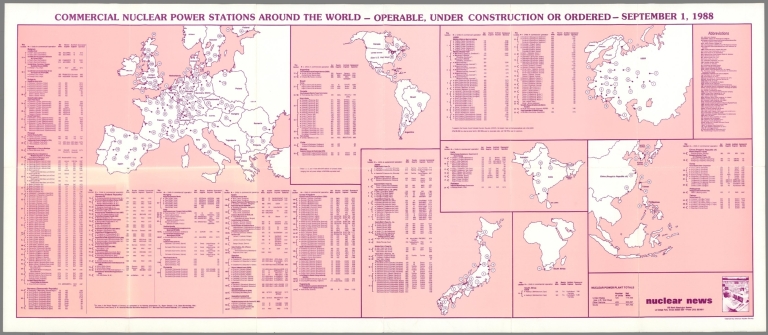
[American Nuclear Society, Nuclear News]
Full Title
Commercial nuclear power stations around the world : operable, under construction or ordered. September 1, 1988. Nuclear News . La Grange Park, Illinois. Copyright by American Nuclear Society.
List No
13514.000
Author
Shuran, E. M.
Full Title
Politicheskaya karta Mira. Glavnoe upravlenie geodezii i kartografii. Pri Sovete Ministrov SSSR Moskva. karta sostavlena nauchno-reduktsionnoy Kartosostavitel'skoy : Chast'yu GUGK . Redaktor Shuran E. M. Tekhnicheskiĭ redactor Kuznetsova O.L.
List No
13528.000
Author
Meḥmed Remzi
Full Title
(Outline map of the World). Umumi jughrafia atlasi = Atlas of general geography. Assar Muhammad Ramzi, Maktab Harbiye Matbaa si. Mulayiyuh sanah 1325 (1907).
List No
13534.003
Note
Outline map of the world by continent.
Author
[Sydow, Emil von., 1812-1873, Wagner, Hermann, 1840-1929]
Full Title
Meeresströmungen und Pflanzenverein Reiche, Tierwelt. Gotha : Justus Perthes. Sydow-Wagners method. Schul-Atlas. XXI.
List No
13557.031
Note
3 maps of the world on 1 sheet. a: Naturliche Pflanzenvereinsreiche. b. Stromungen des Indischen Ozeans in Juli. c. Tiergeographiche Gliederung der Erdoberflache. Showing Ocean currents, and distribution of the wildlife and plant Kingdoms.
Author
[Sydow, Emil von., 1812-1873, Wagner, Hermann, 1840-1929]
Full Title
Die Wirtschaft der Erde. Gotha : Justus Perthes. Sydow-Wagners method. Schul-Atlas. XXI.
List No
13557.041
Note
6 maps on 1 sheet, showing the world economy, agricultural zones, farming, and industry.
Author
[Sydow, Emil von., 1812-1873, Wagner, Hermann, 1840-1929]
Full Title
Gradnetz -Entwurfe. Unter Benutzung des ehemaligen. Entwurfs von H. Wagner. Gotha : Justus Perthes. Sydow-Wagners method. Schul-Atlas XXII.
List No
13558.017
Note
Maps of the surface of the earth with graticule, representing meridians and parallel circles. Includes explanation of projections.
Author
[Sydow, Emil von., 1812-1873, Wagner, Hermann, 1840-1929]
Full Title
Erdansichten. Gotha : Justus Perthes. Sydow-Wagners method. Schul-Atlas XXII.
List No
13558.021
Note
Hemispheric maps of the world, with insets: Land hemisphere, Water hemisphere. Map of South Pole.
Author
[Sydow, Emil von., 1812-1873, Wagner, Hermann, 1840-1929]
Full Title
Tektonik und Geologie der Erde. Gotha : Justus Perthes. Sydow-Wagners method. Schul-Atlas XXII.
List No
13558.023
Note
Tectonic map of the world, with 4 insets at the scale of 1:100,000,000: North America; South America; Africa; Australia and Indonesia. Showing principal tectonic regions. Includes color coded tectonic classification for continental and oceanic.
Author
[Sydow, Emil von., 1812-1873, Wagner, Hermann, 1840-1929]
Full Title
Temperatur, Luftdruck, Winde. Gotha : Justus Perthes. Sydow-Wagners method. Schul-Atlas. XXII.
List No
13558.025
Note
Six maps on 1 sheet, showing Temperature, air pressure and wind in January and July. Includes 4 insets of air circulation in Northern and Southern Hemispheres.
Author
[Sydow, Emil von., 1812-1873, Wagner, Hermann, 1840-1929]
Full Title
Niederschlage, Klimate. Gotha : Justus Perthes. Sydow-Wagners method. Schul-Atlas. XXII.
List No
13558.027
Note
3 maps on 1 sheet. a: Durchschnittliche Jajrliche Niederschlagshöhe. b: Regenzeiten. c. Klimate. Showing average annual and seasonal rainfall and climate map of the world. "Eckerts flächentreue sinuslinien projektion". Includes explanation of the climate formulas from map 9c, on verso.
Author
[Sydow, Emil von., 1812-1873, Wagner, Hermann, 1840-1929]
Full Title
Meeresströmungen und Pflanzenverein Reiche, Tierwelt. Gotha : Justus Perthes. Sydow-Wagners method. Schul-Atlas. XXII.
List No
13558.030
Note
3 maps of the world on 1 sheet. a: Naturliche Pflanzenvereinsreiche. b. Stromungen des Indischen Ozeans in Juli. c. Tiergeographiche Gliederung der Erdoberflache. Showing Ocean currents, and distribution of the wildlife and plant Kingdoms. Includes explanation of the map 10c, on verso.
Author
[Sydow, Emil von., 1812-1873, Wagner, Hermann, 1840-1929]
Full Title
Bevolkerungs- und Rassenverteilung, Polit, Herrschaft. Gotha : Justus Perthes. Sydow-Wagners method. Schul-Atlas. XXII.
List No
13558.033
Note
3 maps of the world on 1 sheet, Showing the Distribution of the Human Race and the geographical population density of the world.
Author
[Spruner von Merz, Karl, 1803-1892., Menke, Heinrich Theodor]
Full Title
Besitzungen der Spanier u. Portugiesen im XVIten Jahrhundert. Von K. v. Spruner, Revision v. Th. Menke. Gezeichnet von B. Hassenstein & Schaffer. Spruner-Menke Hist. Hand-Atlas No. 20. Gotha : Justus Perthes 1871.
List No
13561.046
Note
Map of the World showing the Spanish and Portuguese Empires and their possessions in the 16th century. With 5 insets: Peru 1526 bis 1548. Mexico zur zeit des Cortez. Umgegend von Cuzco. Umgegend der stadt Mexico zur zeit des Cortez. Gebiet des Hauses Habsburg in Europa um die mitle des XVI ten jahrhunderts. Vorder -Indien um das jahr 1520.
Author
Stieler, Adolf, 1775–1836
Full Title
Welt-Karte zur Ubersicht der Luft-Stromungen und der See-Wege. Stieler's Hand-Atlas No. 6. Entworfen & Gez. v. Herm. Berghaus 1867. Nachtr. 1872. Gotha : Justus Perthes. 1875.
List No
13563.012
Note
Map of the world, with 2 insets and compass rose. Showing air currents and sea routes.
|