|
REFINE
Browse All : Images of Virginia from American Revolution
1-15 of 15
Author
[Sartine, Antoine, Depot de la Marine]
Full Title
Carte de la Baie de Chesapeake [inset map] Plan de la Baie Herring en Maryland
List No
15933.022
Author
[Aitken, Robert, Simitiere, Pierre]
Full Title
Map of the Maritime Parts of Virginia Exhibiting the Seat of War and of Ld. Dunmore's depredations in that Colony.
List No
15852.000
Author
[Mitchell, John, Raynal, G.T., Zatta, Antonio]
Full Title
Il Maryland, il Jersey Meridionale, la Delaware, e la Parte Orientale della Virginia, e Carolina Settentrionale. Fogl. VIII.
List No
5007.010
Note
In outline color.
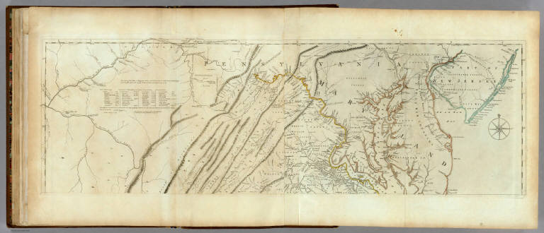
Author
[Jefferys, Thomas, Fry, Joshua, 1700 (ca.)-1754, Jefferson, Peter, 1708-1754]
Full Title
A Map of the most Inhabited part of Virginia containing the whole province of Maryland with Part of Pensilvania, New Jersey and North Carolina. Drawn by Joshua Fry & Peter Jefferson in 1775. Printed for Robt. Sayer ... London. (Northern Section)
List No
0346.023
Note
Map in two sections this being the northern one. Distances and directions shown on chart derived by J. Dalrymple in 1755. Map in outline color by state. Title cartouche on lower half.
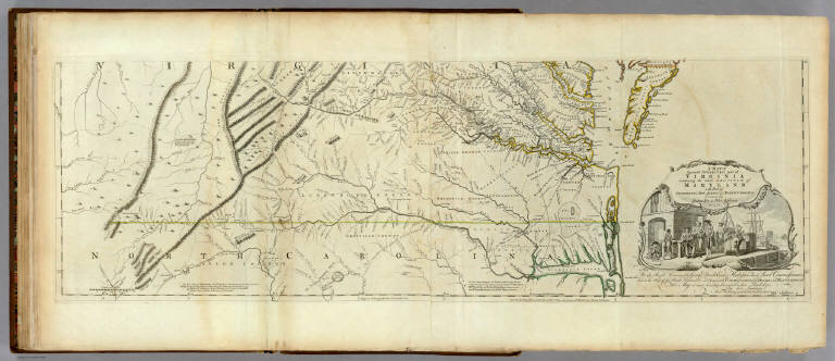
Author
[Jefferys, Thomas, Fry, Joshua, 1700 (ca.)-1754, Jefferson, Peter, 1708-1754]
Full Title
A Map of the most Inhabited part of Virginia containing the whole province of Maryland with Part of Pensilvania, New Jersey and North Carolina. Drawn by Joshua Fry & Peter Jefferson in 1775. Printed for Robt. Sayer ... London. (Southern Section)
List No
0346.024
Note
Southern section in outline color and containing title cartouche. Note below cartouche states: "To the Right Honourable, George Dunk Earl of Halifax First Lord Commissioner; and to the Rest of the Right Honourable and Honourable Commissioners, for Trade and Plantations. This Map is most humbly Inscribed to their Lordships, By their Lordship's Most Obedient & most devoted humble Servt. Thos. Jefferys." Survey lines are noted and explained. In outline color by state.
Author
[Jefferys, Thomas, Fry, Joshua, 1700 (ca.)-1754, Jefferson, Peter, 1708-1754]
Full Title
(Composite of) A Map of the most Inhabited part of Virginia containing the whole province of Maryland with Part of Pensilvania, New Jersey and North Carolina. Drawn by Joshua Fry & Peter Jefferson in 1775. Printed for Robt. Sayer ... London.
List No
0346.025
Note
Distances and directions shown on chart derived by J. Dalrymple in 1755. Note below cartouche states: "To the Right Honourable, George Dunk Earl of Halifax First Lord Commissioner; and to the Rest of the Right Honourable and Honourable Commissioners, for Trade and Plantations. This Map is most humbly Inscribed to their Lordships, By their Lordship's Most Obedient & most devoted humble Servt. Thos. Jefferys." Survey lines are noted and explained. In outline color by state.
Author
Marshall, John
Full Title
Carte des Provinces Meridionales des Etats-Unis. (1807)
List No
0462.002
Note
Fold-out map. Relief shown by sketches. Meridian Paris. Engraved.
Author
Marshall, John
Full Title
Theatre des Operations les plus importantes de l'Armee du Sud, dans la Virginie, dans les deux Carolines, et dans la Georgie. (1807)
List No
0462.011
Note
Engraved. Folded map. Relief shown by hachures.
Author
Marshall, John
Full Title
Investissement et Attaque D'York dans la Virginie. (1807)
List No
0462.013
Note
Engraved. Fold-out map. Relief shown by hachures. Swamps shown. Yorktown attack.
Author
Marshall, John
Full Title
Mont-Vernon, habitation du General Washington, situee dans la Virginie. (1807)
List No
0462.014
Note
Engraved. Estate and General Washington with companions.
Author
Marshall, John
Full Title
A Map of those parts of Virginia, North Carolina, South Carolina, & Georgia, which were the scenes of the most important Operations of the Southern Armies. Compiled by S. Lewis. Engraved for the Life of Washington. Plate VIII. Engraved by Francis Shallus. Published by C.P. Wayne. Philadelphia. (1807)
List No
2559.008
Note
Engraved. Folded map. Relief shown by hachures.
Author
Marshall, John
Full Title
Plan of the Investment and Attack of York in Virginia. Engraved for the Life of Washington. Plate IX. Engraved by Francis Shallus. Published by C.P. Wayne. Philada. (1807)
List No
2559.009
Note
Engraved. Fold-out map. Relief shown by hachures. Swamp shown. Yorktown.
Author
Marshall, John
Full Title
Plan of the Siege of Charleston in S. Carolina. Engraved for Washington's Life. Plate X. Drawn by S. Lewis. Tanner, Sc. Published by C.P. Wayne. Philadelphia. (1807)
List No
2559.010
Note
Engraved. Fold-out map. Relief shown by hachures. Swamp shown. Yorktown. Boom shown across the Cooper River.
Author
Hutchins, Thomas
Full Title
(Title Page to) A Topographical Description Of Virginia, Pennsylvania, Maryland, And North Carolina, Comprehending The Rivers Ohio, Kenhawa, Sioto, Cherokee, Wabash, Illinois, Mississippi, &c ... Published by Thomas Hutchins ... With A Plan of the Rapids of the Ohio, A Plan of the several Villages in the Illinois Country, A table of the Distances between Fort Pitt and the Mouth of the Ohio, all Engraved upon Copper ... London: Printed for the Author, and Sold by J. Almon, opposite Burlington House, in Piccadilly. MDCCLXXVIII.
List No
5045A
Note
First edition, second issue. Streeter: "Hutchins' work is one of the most valuable sources on the West during the British period." The book describes the country portrayed on Hutchins' "New Map of the Western Parts of Virginia, Pennsylvania, Maryland and North Carolina..." which was issued separately but at the same time as the book. With two folding maps, "A Plan of the Rapids, in the River Ohio" and "A Plan of the several Villages in the Illinois Country..."
Author
Renault, Jn. F.
Full Title
Plan of York Town In Virginia And Adjacent Country. Exhibiting the operations of the American French & English armies, during the siege at that place in Oct. 1781. Surveyed from the 22nd to the 28th Octr. Drawn by Jn. F. Renault, with a Crow-pen and presented to the Marques De La Fayette. Engraved by B. Tanner.
List No
5331.000
Note
This is a engraved copy of the original 1782 map of Yorktown by Sebastian Bauman. This copy was made in 1825 and presented to Lafayette on the occasion of his visit to America. The map is not dated, and we have taken the (1825) date from Fite and Freeman. Map is without color.
1-15 of 15
|
![Carte de la Baie de Chesapeake [inset map] Plan de la Baie Herring en Maryland](https://www.davidrumsey.com/rumsey/Size2/RUMSEY~8~1/213/15933022.jpg)