|
REFINE
Browse All : Images of Virginia and Richmond (Va.)
1-19 of 19
Author
Smith, John Calvin
Full Title
Map showing the advance of the Union army under the command of Lieut.-Gen. Grant, also, battle-fields, fortifications, etc. in the vicinity of Richmond. Drawn by J. Calvin smith, from official documents. New Yourk, published by J. disturnell. 1864.
List No
8004.000.
Note
In 1864 President Lincoln installed Ulysses S. Grant as Lieutenant General and general in chief of the Union Army Gen. Grant in turn decided to apply pressure from the East, West and Trans-Mississipppi front and in May-June of this year, Grant began to butt head with General Lee in the eastern Virginia. This hand color map identifying the counties, major roads, rivers, and railroads, as well as the placement of the troops for both sides of the conflict. It shows fortifications and radial distances from the city of Richmond. Includes text, showing population of the city of Richmond, and "Note: The fortifications around Richmond are numbered from 7 to 18 including Fort Jackson and Fort Johnson".
Author
[Saville, Allen J., Inc., Windsor Farms Inc.]
Full Title
Windsor Farms, a residential development on the James River at Richmond. Henrico Co., Virginia : made for Windsor Farms Inc. Richmond VA. by Allen J. Saville, Inc. Engineering and Construction. Plan by John Nolen - Town Planner; Philip W. Foster - associate Harvard Sq., Cambridge, Mass. Lith. by A Hoen & Co. Richmond VA.
List No
6898.000
Note
Windsor Farms, a neighborhood of Richmond Virginia, was one of the first planned communities in the United States after the Radburn community in New Jersey. Color map. Shows boundary, easement, and building lines, properties by blocks, lot number, parcel number, ownership of large plots, acreage, and roads. Includes note and legend.
Author
Colton, G.W.
Full Title
Colton's Virginia & West Virginia. (inset) Richmond, Henrico County. Manchester and Spring Hill, Chesterfield County. Norfolk, Portsmouth and Gosport. Published By G. W & C. B. Colton & Co. No. 172 William St. New York.
List No
0152.036
Note
Prime meridians are Washington D.C. and Greenwich. Relief shown by hachures.
Author
Colton, G.W.
Full Title
Colton's Delaware, Maryland, Virginia and West Virginia. (insets) District of Columbia; Richmond, Henrico County, Manchester and Spring Hill, Chesterfield County, Norfolk, Portsmouth and Gosport. Published By G. W & C. B. Colton & Co. No. 182 William St. New York.
List No
1550.033
Note
Prime meridian is Greenwich.
Author
United States. War Dept. Engineer Bureau
Full Title
Defenses of Washington. Extract of military map of N.E. Virginia, showing forts and roads. Engineer Bureau, War Department, 1865. Map of the city of Richmond, Va. From a survey by I.H. Adams, Assist. U.S. Coast Survey, 1858. With additions from Smith's map of Henrico County, 1853. Prepared at the U.S. Coast Survey office, A.D. Bache, Supt., 1864. Julius Bien & Co., Lith., N.Y. (1891-1895)
List No
1780.089
Note
Two col. maps. Relief shown by hachures. Washington map "Accompanying report of Brig. Gen. Richard Delafield, Chief of Engineers, U.S. Army ... October 30, 1865."
Author
United States. War Department
Full Title
Battery Sawyer, Va. Battery Pruyn, Va. Redoubt Carpenter, Va. Redoubt Anderson, Va., No. 3. Redoubt McConihe, Va. Redoubt Dutton, Va. Redoubt Weed, Va. Redoubt Drake, Va. Castle Thunder, Richmond, Va. May, 1865. Dutch Gap Canal, as finished April, 1865. Pontoon Bridge on the James River above Jones' Landing, from the north side, 68 boats. Julius Bien & Co., Lith., N.Y. (1891-1895)
List No
1780.125
Note
Eleven sepia-toned lithographs. Some accompany report of P.S. Michie; some from original photographs on file in the Office of the Quartermaster General, U.S. Army.
Author
United States. War Department
Full Title
Capitol, Richmond, Va. Front view taken May 1865. Libby Prison, north side. Taken May 1865. Libby Prison, south side, taken May 1865. (with) Post Hospital, City Point, Va., 1865. Rebel Fort, now Federal No. 7 of new lines, Atlanta Ga. (with) Federal Fort No. 7, Atlanta, Ga. New line of defenses looking towards No. 8. Federal Fort No. 8, Atlanta, Ga. New line of defenses looking towards No. 7. Federal Fort No. 9, Atlanta, Ga, new line of defenses ... (with) Federal Fort No. 10, Atlanta, Ga. New line of defenses looking toward No. 9. (with) Federal Fort No. 10, Atlanta, Ga. New line of defenses, looking east ... (with) Federal Fort No. 11, Atlanta, Ga. New line of defenses, looking towards No. 10. Julius Bien & Co., Lith., N.Y. (1891-1895)
List No
1780.126
Note
Eleven sepia-toned lithographs. Some from original photographs in the Office of the Quartermaster General, U.S. Army; some accompany report of Capt. O.M. Poe.
Author
New York Herald
Full Title
Map Of The Seat Of War In Virginia. Positions of the Rebel Forces, Batteries, Intrenchments and Encampments in Virginia. The Fortifications for the Protection of Richmond.
List No
2845.000
Note
Folded broadside inserted in Newspaper, printed without color. Probably a few weeks later than the Stephenson 451.3 (June 17, 1861) because some of the troop counts are increased (Richmond). The engraver credit for Waters & Son is not present, and the map appears to be reengraved. The map has the feel of an "hot off the press" look at the battlefields of the war. Shows military fortifications, roads and railroads. Relief shown by hachures.
Author
United States. War Dept. Engineer Bureau
Full Title
Central Virginia showing Lieut Gen'l U.S. Grant's Campaign and Marches of the Armies under his Command in 1864-5. Engineer Bureau War Dept. Prepared by Order of the Secretary of War For the Officers of the U.S. Army under the command of Lieut. Gen. U.S. Grant.
List No
3854.000
Note
Extremely detailed map of central Virginia showing the routes of Grant's various armies in various colors. This version adds to sheets at the top to the original version (Stephenson 513). Plate 100:1 in "Atlas to Accompany..."
Author
United States. War Dept. Engineer Bureau
Full Title
Region embraced in the Operations of the Armies against Richmond and Petersburg. Engraved at the Engineer Bureau, War Dep. 1865. Authorities. North of James & Appomattox from Photograph Map Captured from the Enemy and Surveys of Maj. P.S. Michie Corps Of Engineers. South of Do. from Surveys of Col. N. Michler Corps Of Engineers.
List No
3875.000
Note
Detailed map of the area between Richmond and Petersburg, showing the street patterns of both cities. Differs from the Stephenson 644 in not having the 39th Cong. 1st Session printed on it. A very elegant map. Two sheets joined; map without color. Plate 100:2 in "Atlas to Accompany..."
Author
Abbot, Henry L.
Full Title
Campaign Map, Army Of The Potomac. Map No. 3 White House To Harrisons Landing. Prepared By Command Of Maj. Gen. George B. McClellan, U.S.A. Commanding Army Of The Potomac Brig. Gen. A.A. Humphreys ... Compilation under the Direction of Brig. Gen. A.A. Humphreys, By Capt. H.L. Abbot, Top. Engrs. Engraved by W.H. Dougal.
List No
3877.000
Note
Shows troop positions near Richmond (Fair Oaks, etc.) and Harrisons Landing. List of Authorities given. See other two campaign maps in this series (our #3878, 3879). Date is estimated. Plate 19:1 in "Atlas to Accompany..." Without color.
Author
[U.S. War Department, Weyss, John E.]
Full Title
Map of the Region between Gettysburg, Pa. and Appomattox Court House, Va. exhibiting the connection between the Campaign And Battle-Field Maps prepared by Authority of the Hon. Secretary of War, under the direction of ... A.A. Humphreys ... N. Michler... Compiled and Drawn by Major John E. Weyss, C. Thompson and J. De la Camp. War Department. Office of the Chief of Engineers. 1869.
List No
3881.001
Note
Large key map in two sheets showing all the atlas maps used in the "Military Maps Illustrating the Operations of the Armies of the Potomac & James..." in relation to each other, and to the country around Washington and Richmond. Separately issued. Map is in full beige color with water in blue.
Author
[U.S. War Department, Weyss, John E.]
Full Title
Cold Harbor. From Surveys under the direction of Bvt. Brig. Gen N. Michler, Maj. of Engineers and Bvt. Lieut. Col. P.S. Michie, Capt. of Engineers By Command of Bvt. Maj. Genl. A.A. Humphreys, Brig. Genl. & Chief of Engineers. 1867. Surveyed & drawn by Maj. J.E. Weyss, assisted by F. Theilkuhl, J. Strasser & G. Thompson. Photolith. by the N.Y. Lithographing, Engraving & Printing Co., Julius Bien, Supt.
List No
3881.008
Note
Full printed color map. Map of the Cold Harbor Battlefield and vicinity, north of Richmond, Virginia.
Author
Magnus, Charles
Full Title
One Hundred & Fifty Miles Around Richmond. Charles Magnus' New York Printing Establishment - Offices: 12 Frankfort St., New York, and 520 7th St. Washington, D.C. Eleventh Edition 3000 of Magnus' all around Map ... Battle Ground of the Wilderness and Spottsylvania Court House. May, 5-23, 1864. Price 50 Cents. (with 9 small maps) Memphis And Nashville, Tenn. 225 Miles Around Vicksburg, Miss. 250 Miles Around Galveston, Texas. 200 Miles Around Montgomery, Ala. 100 Miles Around Milledgeville, Ga. Fortifications Around Richmond, Va. 250 Miles Around Charleston, S.C. 100 Miles Around Chattanooga, Tenn. Knoxville, Tenn., Danville, Ky. And Parkersburg, Va.
List No
3969.000
Note
Illustrated in Stephenson (10th edition). This must have been a popular map - Stephenson shows 12 editions (but not this 11th edition). The central circular map shows the country around Richmond, and is surrounded by nine smaller circular maps of other battle areas. Map in blue with red border and title.
Author
Colton, G.W.
Full Title
Colton's Virginia & West Virginia. (Insets)Richmond, Henrico County, Manchester and Spring Hill, Chesterfield County, Norfolk, Portsmouth and Gosport. Published By G. W & C. B. Colton & Co., No. 172 William St. New York.
List No
4587.036
Note
Prime meridians are Washington D.C. and Greenwich.
Author
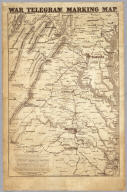
Prang, L. & Co.
Full Title
War Telegram Marking Map. L. Prang & Co. Print Publishers, 159, Washington St. Boston ... Entered ... 1862 by L. Prang & Co. ... Massachusetts.
List No
4682.000
Note
In the "Explanations" below the map Prang states that this is "a map to mark the change of positions of the Union forces in red pencil and the rebel forces in blue, on the receipt of every telegram from the seat of war..." He goes on to say that he will furnish the necessary pencils and that "with the aid of a little soft bread" prior markings can be erased to show the latest developments. Printed in brown ink, showing the area between Richmond and Washington in good detail.
Author
Johnson, Alvin Jewett, 1827-1884.
Full Title
Johnson's map of the vicinity of Richmond, and Peninsular Campaign in Virginia. Showing also the interesting localities along the James, Chickahominiy and York Rivers. Compiled from the official maps of the War Department. Published by Alvin J. Johnson & Son, New York. Entered ... 1862, by A.J. Johnson ... New York. (to accompany) Johnson's New Illustrated Family Atlas Of The World ... MDCCCLXXX (1880).
List No
4830.079
Note
Engraved hand colored in outline map on 2 sheets. Shows towns, roads, railroads, rivers, lakes, bays, islands, and swamps. The Peninsula Campaign (also known as the Peninsular Campaign) of the American Civil War was a major Union operation launched in southeastern Virginia from March through July 1862. Relief shown by hachures. Depth shown by soundings and isolines.
Author
Hughes, W.C. Major
Full Title
Hughes Military Map Of Richmond & Petersburgh, Va. Showing the Rebel Fortifications drawn on the ground for the War Department by Major W.C. Hughes of Michigan. Published by Philip & Solomons, Washn. D.C. Print by J.F. Gedney, Washn. Willenbucher, Lith. Respectfully dedicated to the Army of the Potomac.
List No
5443.000
Note
Two color map on linen with blue used for the rivers. Two inset views entitled "Libby Prison" and "Belle Isle." Date estimated.
Author
[Hall, E.S., New York Herald]
Full Title
Important Operations in Kentucky and Tennessee. The Battle Ground of Gen. Nelson at Piketon--The Brilliant Victory Over the Rebels--Situation of the Bridges Destroyed by the Unionists of Tennessee--The Cumberland Gap--Positions of the Contending Armies, &c., &c., &c. New York Herald War Maps and Diagrams. (Pages) 4 and 5.
List No
5472.002
Note
Maps without color. Each map has its own title: The Seat of War In Kentucky; The Fight At Santa Rosa Island; Map Of The Rebel Capital (Richmond); The Affair At Chicamacomico; Very Curious Rebel Semi-Official Pictorial View Of The Battle Of Bull Run.
1-19 of 19
|