|
REFINE
Browse All : Images of Virginia and North Carolina and Maryland
1-9 of 9
Author
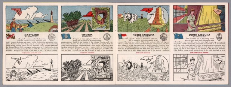
[Fisher, Joseph R., Planters Peanuts (Firm)]
Full Title
Maryland : The old line state -- Virginia : The old dominion -- North Carolina : The tar heel state -- South Carolina : The palmetto state.
List No
14374.006
Note
Four views, representing Maryland, Virginia, North Carolina and South Carolina. Views show examples of the landscape and natural resources. Each view includes an inset map of the state, which marks the location of the capital city with a star. Accompanied by descriptive text, the state flags, seals and flowers: black-eyed Susan, dogwood, dogwood and yellow jessamine, respectively. The view of each state appears both in color (on top) and in black and white (bottom), the latter inviting coloration. Together, views are 18 x 52 cm, on two sheets 20 x 54 cm.
Author
[Jefferys, Thomas, Fry, Joshua, 1700 (ca.)-1754, Jefferson, Peter, 1708-1754]
Full Title
(Composite of) A Map of the most Inhabited part of Virginia containing the whole province of Maryland with Part of Pensilvania, New Jersey and North Carolina. Drawn by Joshua Fry & Peter Jefferson in 1775. Printed for Robt. Sayer ... London.
List No
0346.025
Note
Distances and directions shown on chart derived by J. Dalrymple in 1755. Note below cartouche states: "To the Right Honourable, George Dunk Earl of Halifax First Lord Commissioner; and to the Rest of the Right Honourable and Honourable Commissioners, for Trade and Plantations. This Map is most humbly Inscribed to their Lordships, By their Lordship's Most Obedient & most devoted humble Servt. Thos. Jefferys." Survey lines are noted and explained. In outline color by state.
Author
Mitchell, Samuel Augustus
Full Title
County Map Of Virginia, and North Carolina. 23. Entered ... 1860, by S. Augustus Mitchell, Jr. ... Pennsylvania.
List No
0565.015
Note
In full color by county.
Author
[Morden, Robert, approximately 1650-1703, Cockerill, Thomas, active 1674-1702]
Full Title
(Text Page to) Of New England (4) -- A description of Carolina (1).
List No
14323.183
Note
On left - descriptive text for map, New England and New York, on prior page (373). Text spans pages 373-378. Includes section: New York. Text spans pages 369-372. On right - map of the South Atlantic States. Map includes title cartouche: Carolina, Virginia, Maryland & New Jarsey, by Robt. Morden. Shows political boundaries, cities, topography, drainage, coastline and islands. Relief shown pictorially. Contains latitudinal and longitudinal lines. Map is 12 x 11 cm, on sheet 15 x 20 cm. Accompanied by descriptive text. Text spans pages 379-383.
Author
[Colton, G.W., Fisher, Richard Swainson]
Full Title
Maryland, Virginia, North Carolina, and South Carolina. (inset) The District of Columbia. (inset) Vicinity of Charleston. (inset) Vicinity of Baltimore, Md.
List No
1690.074
Note
Relief shown by hachures.
Author
Mitchell, Samuel Augustus Jr., 1792-1868
Full Title
Maryland, Virginia, West Virginia, and North Carolina. (to accompany) Mitchell's New Reference Atlas for the Use of Colleges, Libraries, Families and Counting Houses. Philadelphia: Published By E.H. Butler & Co. 1865.
List No
2516.012
Note
Hand colored map. Relief shown by hachures. Showing administrative divisions, major cities, railways, rivers, lakes and mountains. Prime meridians are Greenwich and Washington.
Author
Lange, Henry, 1821-1893.
Full Title
Der Bundesdistrict Columbia, Virginien, Nord-Carolina, Maryland, u. Delaware. (with inset map) Der Bundesdistrict Columbia. H. Lange's Atlas v. Nord Amerika Blatt IV. Braunschweig: Verlag v. George Westermann. Lith. Anst. von L. Kraatz in Berlin.
List No
2743.004
Note
Engraved map. Borders hand col. Shows roads, canals, railroads, etc. Relief shown by hachures. Scale of inset map (ca. 1:370,000)
Author
Hutchins, Thomas
Full Title
(Title Page to) A Topographical Description Of Virginia, Pennsylvania, Maryland, And North Carolina, Comprehending The Rivers Ohio, Kenhawa, Sioto, Cherokee, Wabash, Illinois, Mississippi, &c ... Published by Thomas Hutchins ... With A Plan of the Rapids of the Ohio, A Plan of the several Villages in the Illinois Country, A table of the Distances between Fort Pitt and the Mouth of the Ohio, all Engraved upon Copper ... London: Printed for the Author, and Sold by J. Almon, opposite Burlington House, in Piccadilly. MDCCLXXVIII.
List No
5045A
Note
First edition, second issue. Streeter: "Hutchins' work is one of the most valuable sources on the West during the British period." The book describes the country portrayed on Hutchins' "New Map of the Western Parts of Virginia, Pennsylvania, Maryland and North Carolina..." which was issued separately but at the same time as the book. With two folding maps, "A Plan of the Rapids, in the River Ohio" and "A Plan of the several Villages in the Illinois Country..."
Author
W. & A.K. Johnston Limited
Full Title
Virginia, West Virginia, Maryland, Delaware. North Carolina, South Carolina, Georgia.
List No
6921.122
1-9 of 9
|