|
REFINE
Browse All : Images of Virginia and Florida
1-10 of 10
Author
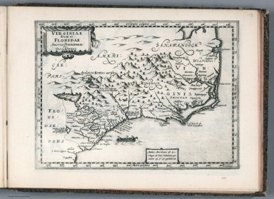
[Mercator, Gerhard, 1512-1594, Hondius, Jodocus, 1563-1612, Hondius, Hendrik, 1597-1651]
Full Title
Virginiae Item et Floridae Americae Provinciarum, nova Descriptio.
List No
10534.359
Author
[Mercator, Gerhard, 1512-1594, Hondius, Jodocus, 1563-1612]
Full Title
Virginiae Item et Floridae Americae Provinciarum, nova Descriptio.
List No
10501.508
Author
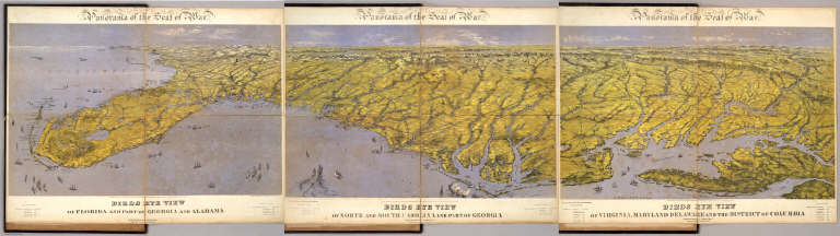
Bachmann, John
Full Title
(Composite of) Panorama of the Seat of War. Birds eye view of Florida and part of Georgia and Alabama .. North and South Carolina and part of Georgia .. Virginia, Maryland, Delaware and the District of Columbia. John Bachmann, Publisher, 115 & 117 Nassau St., New York. Entered ... 1861 by John Bachmann ... New York. Drawn from Nature and Lith. by John Bachmann.
List No
5491.000
Note
Composite map image from three separate issues.
Author
Arbuckle Bros.
Full Title
Florida, Virginia, Indiana, Rhode Island. Copyright 1889 Arbuckle Bros. N.Y.
List No
0027.004
Note
Sheet with maps of four states in full color. Florida is noted for its oranges and Rhode Island (called "Little Rhody") for its sewing thread. Each card measures 7.5 x 12.5 cm.
Author
[Mercator, Gerhard, 1512-1594, Hondius, Iodocus, 1563-1612]
Full Title
Virginia et Florida. (to accompany) Atlas minor Gerardi Mercatoris.
List No
11201.455
Note
Map of Virginia and Florida, eastern coast of North America from the Chesapeake Bay south to St. Augustine. Several named towns are shown along the coast, and the Native American village of Secotan is shown in what is now eastern North Carolina. Shows British and Spanish colonies. Relief shown pictorially.
Author
[Mercator, Gerhard, 1512-1594, Hondius, Jodocus, 1563-1612, Saltonstall, Wye]
Full Title
Virginia. Virginia et Florida. (to accompany) Historia mundi : or Mercator's atlas. London Printed for Michaell Sparke, . and are to be sowld in Greene Arboiure, 1637. Second edytion.
List No
11248.665
Note
Copper-engraving uncolored map of Virginia and Florida, eastern coast of North America. Several named towns are shown along the coast, and the Native American village of Secotan is shown in what is now eastern North Carolina.Relief shown pictorially.
Author
[Janssonius van Waesberge, Johannes, Mercator, Gerhard, 1512-1594, Cloppenburg, Johannes, 1592-1652]
Full Title
Virginiae item et Floridae Americae Provinciarum, nova descriptio. (to accompany) Atlas sive Cosmographicae Meditationes de Fabrica mundi et fabricati figura. De novo multis in locis emendatus novisque tabulis auctus. Amsterodami, apud Iohannem Ianssonium van Waesberge. Anno, 1673.
List No
11487.177
Note
Copper engraved map of the southeastern part of North America, covers Virginia and Florida. Cover the coast from Chesapeake Bay to St. Augustine. Shows towns, villages, mountains, Indian settlement, and rivers. Relief shown pictorially. Includes notes.
Author
[Ogilby, John, 1600-1676, Montanus, Arnoldus, 1625?-1683]
Full Title
Virginiae Partis australis, et Floridae partis orientalis, interjacentiumq regionum Nova Descriptio .
List No
12241.045
Note
Inserted in this copy, present in the first issue 1671 but not published in this second issue 1671, replaced by the Lord Proprietors' map.
Author
[Michler, Nathaniel, United States. War Department]
Full Title
Battle-field of Youngs Branch or Manassas Plains, battle fought July 21st, 1861. Tracing forwarded to the Chief of Engineers U.S.A. by Maj. N. Michler ... Map of the rebel fortifications at Columbus, Ky., surveyed under the direction of Brig. Genl. Geo. W. Cullum, Chief of Staff and engineers, Dept. of the Mississippi, 1862. (with) Map showing the position of the batteries used by the U.S. forces in the reduction of Fort Pulaski, April 10th & 11th, 1862. Accompanying Report of Brig. Gen. Quincy A. Gillmore, U.S. Vols. (with) Siege of Fort Pulaski, map of the mouth of Savannah River and adjacent islands ... (with) Action at Front Royal, Va., May 23d. 1862. Accompanying Report of Lieut. Col. Charles Parham, Twenty-ninth Pennsylvania Infantry. (with) Sketch of Fort Pickens, Florida, by Lt. Langdon ... 1861. (with) Reconnaissance of the battle-field at Bull Run, Va., fought July 21, 1861. Made on March 14, 1862 by Henry L. Abbot ... (with) Skirmishes near Bailey's Cross-roads, Va., August 28-30, 1861. Accompanying Report of Major S.G. Champlin ... (with) Accompanying Report of Brig. Gen. Louis Blenker, U.S. Vols., of information obtained from scouting parties, dated Hunter's Chapel, Va., Nov. 5, 1861. Julius Bien & Co., Lith., N.Y. (1891-1895)
List No
1780.005
Note
Two col. maps with 8 ancillary maps. Relief shown by contours, hachures and spot heights. Scales of main maps ca. 1:26,400 and 1:14,400.
Author
Apgar, E.A.; Apgar, A.C.
Full Title
(Text Page and Map) Map of the Middle States. Map of the Southern States.
List No
9645.006
Note
Instructive text. Map tinted in pale pastels; also with bold red geometric figures.
1-10 of 10
|