|
Author
Finley, Anthony
Full Title
Virginia. Philada. Published by A. Finley. J.H. Young Sc.
List No
0285.018
Note
Full color by county.
Author
[Bowen, Emanuel, Gibson, John]
Full Title
Pennsylvania, Maryland And Virginia. (to accompany) Atlas Minimus or a New Set of Pocket Maps of the Several Empires, Kingdoms and States of the Known World, with Historical Extracts relative to each. Drawn and Engraved by J. Gibson from the Best Authorities, Revis'd, Corrected and Improv'd by Eman: Bowen Geographer to His Majesty.
List No
0300.046
Note
First edition. The "Historical Extracts" are short bits of text printed on the maps giving relevant geographical information. A revised edition was published in London in 1792. In 1759, another edition was published adding separate geographical descriptions and correcting some of the maps (see our copy). The Philadelphia 1798 edition by Mathew Carey incorporates the 1759 edition text word for word (excepting the maps of United States which Carey omits in favor of his pocket atlas of the U.S.). Gibson and Bowen made the four sheet map of North America (Stevens 49), and Gibson made the four sheet map of America (Stevens 3).
Author
Gray, O.W.
Full Title
Gray's Atlas Map of Virginia & West Virginia. (insets) Richmond. Norfolk.
List No
0310.048
Author
[Gray, Frank A., Gray, O.W.]
Full Title
Virginia and West Virginia by Frank A. Gray. Copyright 1877 by O.W. Gray. (insets) Environs of Harpers Ferry. Hampton Roads and the Approach. Hypsometric Sketch of Virginia and West Virginia. Norfolk Harbor.
List No
0312.023
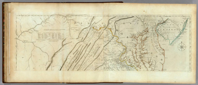
Author
[Jefferys, Thomas, Fry, Joshua, 1700 (ca.)-1754, Jefferson, Peter, 1708-1754]
Full Title
A Map of the most Inhabited part of Virginia containing the whole province of Maryland with Part of Pensilvania, New Jersey and North Carolina. Drawn by Joshua Fry & Peter Jefferson in 1775. Printed for Robt. Sayer ... London. (Northern Section)
List No
0346.023
Note
Map in two sections this being the northern one. Distances and directions shown on chart derived by J. Dalrymple in 1755. Map in outline color by state. Title cartouche on lower half.
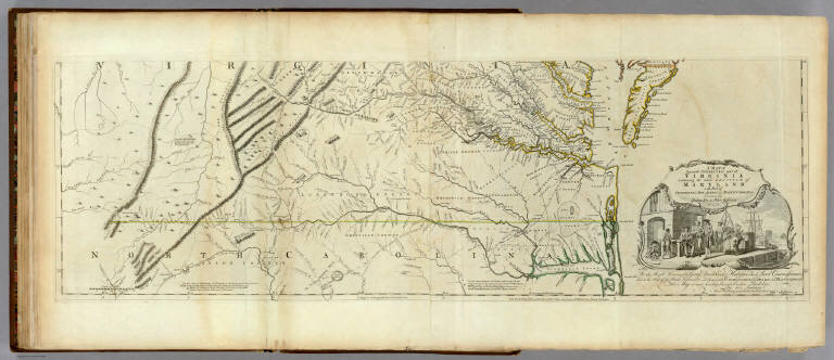
Author
[Jefferys, Thomas, Fry, Joshua, 1700 (ca.)-1754, Jefferson, Peter, 1708-1754]
Full Title
A Map of the most Inhabited part of Virginia containing the whole province of Maryland with Part of Pensilvania, New Jersey and North Carolina. Drawn by Joshua Fry & Peter Jefferson in 1775. Printed for Robt. Sayer ... London. (Southern Section)
List No
0346.024
Note
Southern section in outline color and containing title cartouche. Note below cartouche states: "To the Right Honourable, George Dunk Earl of Halifax First Lord Commissioner; and to the Rest of the Right Honourable and Honourable Commissioners, for Trade and Plantations. This Map is most humbly Inscribed to their Lordships, By their Lordship's Most Obedient & most devoted humble Servt. Thos. Jefferys." Survey lines are noted and explained. In outline color by state.
Author
[Jefferys, Thomas, Fry, Joshua, 1700 (ca.)-1754, Jefferson, Peter, 1708-1754]
Full Title
(Composite of) A Map of the most Inhabited part of Virginia containing the whole province of Maryland with Part of Pensilvania, New Jersey and North Carolina. Drawn by Joshua Fry & Peter Jefferson in 1775. Printed for Robt. Sayer ... London.
List No
0346.025
Note
Distances and directions shown on chart derived by J. Dalrymple in 1755. Note below cartouche states: "To the Right Honourable, George Dunk Earl of Halifax First Lord Commissioner; and to the Rest of the Right Honourable and Honourable Commissioners, for Trade and Plantations. This Map is most humbly Inscribed to their Lordships, By their Lordship's Most Obedient & most devoted humble Servt. Thos. Jefferys." Survey lines are noted and explained. In outline color by state.
Author
Johnson, A.J.
Full Title
Johnson's Virginia, Delaware, and Maryland. By Johnson and Ward.
List No
0352.024
Note
Full color by county, with heavy outlines around the state. Accompanied by vignette of the Fortress Monroe, VA. Relief shown by hachures. Prime meridians are Greenwich and Washington D.C.
Author
Johnson, A.J.
Full Title
Johnson's Map of the Vicinity of Richmond, and Peninsular Campaign in Virginia. Showing also the Interesting Localities along the James, Chickahominy, and York Rivers. Compiled from the Official Maps of the War Department. By Johnson and Ward.
List No
0352.025
Note
In full color by county. Shows roads, railroads, settlements, and swamps. Prime meridians are Greenwich and Washington D.C. Relief shown by hachures. Depth shown by soundings.
Author
Johnson, A.J.
Full Title
Johnson's Virginia, Delaware, Maryland & West Virginia. Entered ... 1864.
List No
0358.031
Author
Johnson, A.J.
Full Title
Johnson's Map of the Vicinity of Richmond,and Peninsular Campaign in Virginia. Entered ... 1862.
List No
0358.033
Author
Leahy, J.F.
Full Title
(Index to) Leahy's Hotel Guide and Railway Distance Maps. Virginia.
List No
0425.122
Note
Alphabetical index list of the Hotels of the town with the number of rooms of each, their rates per day and the population of the town. Includes population of the states, Explanation of abbreviation of the railroad of the state, and advertisement.
Author
Leahy, J.F.
Full Title
Leahy's Hotel Guide and Railway Distance Map of the State of Virginia. Published by American Hotel Register Company. Leahy Build., 228-234 W. Ontario St., Chicago, Ill. Copyrighted by J.F. Leahy, Jan., 1934.
List No
0425.123
Note
Map printed without color. Includes name of the railroad entering the town, and distance between towns.
Author
Marshall, John
Full Title
Carte des Provinces Meridionales des Etats-Unis. (1807)
List No
0462.002
Note
Fold-out map. Relief shown by sketches. Meridian Paris. Engraved.
Author
Marshall, John
Full Title
Theatre des Operations les plus importantes de l'Armee du Sud, dans la Virginie, dans les deux Carolines, et dans la Georgie. (1807)
List No
0462.011
Note
Engraved. Folded map. Relief shown by hachures.
Author
Marshall, John
Full Title
Investissement et Attaque D'York dans la Virginie. (1807)
List No
0462.013
Note
Engraved. Fold-out map. Relief shown by hachures. Swamps shown. Yorktown attack.
Author
Marshall, John
Full Title
Mont-Vernon, habitation du General Washington, situee dans la Virginie. (1807)
List No
0462.014
Note
Engraved. Estate and General Washington with companions.
Author
[Lawrence, Martin, Washington, George]
Full Title
George Washington's survey of the site of Belhaven (Alexandria), Virginia, about 1748 (upper); his plan of the town, believed to have been drawn a year later (lower).
List No
0465.023
Note
Two maps on one plate. Include annotation. title on the lower map reads: A plan of Alexandria now Belhaven.
Author
[Lawrence, Martin, Washington, George]
Full Title
Two complex surveys. George Washington's land on Four Mile Run, Virginia, Surveyed in April, 1799 (left); a tract on the Potomac near Pawpaw, West Virginia, surveyed in April, 1751 (right).
List No
0465.025
Note
Two plans on one plate. Include annotation by George Washington.
Author
[Lawrence, Martin, Washington, George]
Full Title
Virginia, showing in red the places visited by George Washington. See also plate 32.
List No
0465.037
Note
Color map. Showing Washington's headquarters, battlefield, capital of the United States, locality known and approximate. Date estimated.
Author
[Lawrence, Martin, Washington, George]
Full Title
Annapolis, Maryland, (Scale 1:7,500), (upper), and Alexandria, Virginia, (scale 1:12,500) (lower), showing localities associated with George Washington.
List No
0465.049
Note
Two uncolored maps on one plate. Includes a table showing locations in Annapolis, Maryland, and Alexandria, Virginia associated with George Washington.
Author
Melish, John
Full Title
Map of the American Coast, from Lynhaven Bay to Narraganset Bay, by John Melish.
List No
0495.002
Note
Fold-out map in outline color stretching from Long Island Sound to Norfolk, Virginia.
Author
Mitchell, Samuel Augustus
Full Title
Map of the Middle States. Engraved to Illustrate Mitchell's School and Family Geography. No. 7. Engraved by J.H. Young. Entered ... 1839, by S. Augustus Mitchell ... Connecticut.
List No
0523.005
Note
In full color by state. Includes explanation of symbols used to represent towns, railroads, canals and distance.
Author
Johnson, A.J.
Full Title
Johnson's Virginia, Delaware, Maryland, and West Virginia, Published By Johnson and Ward.
List No
0535.023
Note
In full color by county. Accompanied by vignettes of the General Post Office, Treasury Buildings, Patent Office, Fortress Monroe, and University of Virginia (Charlottesville). Relief shown by hachures. Meridians Greenwich and Washington D.C.
Author
Johnson, A.J.
Full Title
Johnson's Map of the Vicinity of Richmond, and Peninsular Campaign in Virginia (American Civil War) ... By Johnson and Ward.
List No
0535.024
Note
In full color by county. Shows roads, railroads, settlements, swamps and water depth soundings. Meridians Greenwich and Washington D.C.
Author
Mitchell, Samuel Augustus
Full Title
A New Map Of Virginia With Its Canals, Roads & Distances from place to place, along the Stage & Steam Boat Routes. Published By S. Augustus Mitchell, N.E. corner of Market & 7th Street Philada., 1846. Entered ... 1846 by H.N. Burroughs ... Pennsylvania.
List No
0537.018
Note
Full color by county with steamboat route distances charted. Profile of the Chesapeake & Ohio Canal included.
Author
Mitchell, Samuel Augustus
Full Title
A New Map of Virginia with its Canals, Roads & Distances from Place to Place along the stage & steam boat Routes. Published By S. Augustus Mitchell. N.E. corner of Market & 7th. Streets. Philadelphia. (inset) Profile of the Chesapeake & Ohio Canal.
List No
0545.021
Note
Full color map. Includes explanation chart, and reference to steam boat routes. Prime meridian is Washington D.C. Relief shown by hachures.
Author
Mitchell, Samuel Augustus
Full Title
County Map Of Virginia, and North Carolina. 23. Entered ... 1860, by S. Augustus Mitchell, Jr. ... Pennsylvania.
List No
0565.015
Note
In full color by county.
Author
Mitchell, Samuel Augustus Jr.
Full Title
County map of Virginia and West Virginia. Drawn & Engd. by W.H. Gamble Phila. Entered ... 1863 by S. Augustus Mitchell, Jr. ... Pennsylvania.
List No
0572.024
Note
Full color map by county. Relief shown by hachures. Prime meridians are Greenwich and Washington, D.C.
Author
Mitchell, Samuel Augustus Jr.
Full Title
County map of Virginia and West Virginia. Drawn & Engd. by W.H. Gamble Phila. Entered ... 1867 by S. Augustus Mitchell, Jr. ... Pennsylvania.
List No
0579.024
Note
Color map by county. Relief shown by hachures. Prime meridians are Greenwich and Washington, D.C.
Author
Mitchell, Samuel Augustus
Full Title
County map of Virginia and West Virginia. Drawn & engd. (by) W.H. Gamble, Phila. Entered ... 1879 by S. Augustus Mitchell ... Washington. (1880)
List No
0586.020
Note
Hand colored. Relief shown by hachures. Shows settlements, railroads, rivers, etc. Prime meridians: Greenwich and Washington.
Author
Mitchell, Samuel Augustus Jr.
Full Title
County map of the states of Delaware, Maryland, Virginia and West Virginia. Copyright by S. Augustus Mitchell 1884.
List No
0592.023
Note
Hand colored. Relief shown by hachures. Shows settlements, railroads, rivers, etc. Includes 2 insets. Prime meridians: Greenwich and Washington.
Full Title
County map of the states of Delaware, Maryland, Virginia and West Virginia. Copyright 1887 by Wm. M. Bradley & Bro. (1890)
List No
0594.022
Note
Hand colored. Relief shown by hachures. Shows settlements, railroads, rivers, etc. Includes 2 insets. Prime meridians: Greenwich and Washington.
Author
[Morse, Charles W., Colby, Charles A.]
Full Title
Virginia.
List No
0623.022
Author
Morse, Jedidiah
Full Title
Map of Virginia, Maryland and Delaware. I. Mulow Sc. 6 James St. Covt. Gardn. Published July 16, 1794 by I. Stockdale, PIccadilly.
List No
0632.016
Note
Large foldout uncolored map showing roads, cities, and mountians in the area.
Author
Rand McNally and Company
Full Title
(Covers to) Rand, McNally & Co.'s Virginia and West Virginia. (with 19 page index) Rand, McNally & Co.'s Indexed Maps Of Virginia And West Virginia ... Chicago: Rand, McNally & Co., Printers And Engravers, 77 & 79 Madison Street. (on verso) Entered ... 1877, by Rand, McNally & Co. ... Washington.
List No
0747.001
Note
Gazetteer. Very early Rand McNally pocket map. The map is from the Business Atlas of 1877. Printed outline color by county. Folded into red cloth covers 15.5x9 with "Rand, McNally & Co's. Indexed Map of Virginia And West Virginia." stamped in gilt.
Author
Rand McNally and Company
Full Title
(Title Page to) Rand, McNally & Co.'s Virginia and West Virginia. (with 19 page index) Rand, McNally & Co.'s Indexed Maps Of Virginia And West Virginia ... Chicago: Rand, McNally & Co., Printers And Engravers, 77 & 79 Madison Street. (on verso) Entered ... 1877, by Rand, McNally & Co. ... Washington.
List No
0747.002
Note
Gazetteer. Very early Rand McNally pocket map. The map is from the Business Atlas of 1877. Printed outline color by county. Folded into red cloth covers 15.5x9 with "Rand, McNally & Co's. Indexed Map of Virginia And West Virginia." stamped in gilt.
Author
Rand McNally and Company
Full Title
Rand, McNally & Co.'s Virginia and West Virginia. (with 19 page index) Rand, McNally & Co.'s Indexed Maps Of Virginia And West Virginia ... Chicago: Rand, McNally & Co., Printers And Engravers, 77 & 79 Madison Street. (on verso) Entered ... 1877, by Rand, McNally & Co. ... Washington.
List No
0747.003
Note
Gazetteer. Very early Rand McNally pocket map. The map is from the Business Atlas of 1877. Printed outline color by county. Folded into red cloth covers 15.5x9 with "Rand, McNally & Co's. Indexed Map of Virginia And West Virginia." stamped in gilt.
Author
[Reid, John, Winterbotham, W.]
Full Title
The State of Virginia from the best Authorities. 1796. Published by John Reid N. York. B. Tanner, sculpt.
List No
0845.014
Note
Uncolored.
Author
Scott, Joseph
Full Title
Virginia.
List No
0887.019
Note
Uncolored.
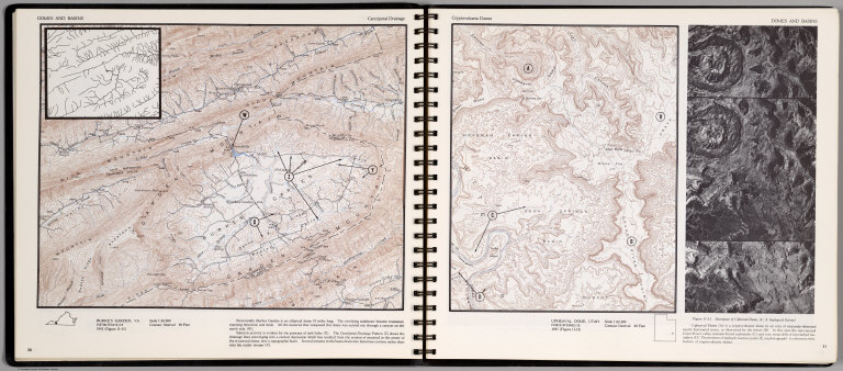
Author
[Scovel, James L., O'Brien, Emmett J]
Full Title
Domes & Basin. Centripetal Drainage. Burkes Garden, VA. (on opposite page) Cryptovocanic Domes. Upheaval Dome, Utah. (with inset view) Stereopair of Upheaaval Dome ...
List No
0889.019
Note
Two contour maps on two pages, includes text, and outline location map. Inset: Magnified section of the Centripetal drainage patterns. Relief shown by contours and spot height.
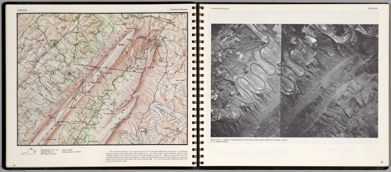
Author
[Scovel, James L., O'Brien, Emmett J]
Full Title
Streams. Entrenched Meander. Strasburg, Va. (S) (on opposite page) Entrenched Meader. Stereopair of Shenandoah River in the Massannutten Mountain Region near Strasburg.
List No
0889.051
Note
Contour map, with text, and location maps. Relief shown by contours and spot heights.
Author
Tanner, Henry S.
Full Title
A New Map of Virginia with the Canals, Roads & Distances from place to place along the Stage & Steam Boat Routes by H.S. Tanner. (inset) Profile of the Chesapeake & Ohio Canal.
List No
0976.019
Author
Tanner, Henry S.
Full Title
A New Map Of Virginia With Its Canals, Roads & Distances from place to place, along the Stage & Steam Boat Routes. by H.S. Tanner. Engraved by W. Brose, Philadelphia. Entered ... 1833 by H.S. Tanner ... Pennsylvania. Published by H.S. Tanner, No. 144 Chesnut St. Philadelphia. (above neat line) Tanner's Universal Atlas.
List No
0977.014
Note
In full color by county with profile of the Chesapeake and Ohio canal. Steamboat routes and distances charted.
Author
Tanner, Henry S.
Full Title
A New Map of Virginia with the Canals, Roads & Distances from place to place along the Stage & Steam Boat Routes by H.S. Tanner. (inset) Profile of the Chesapeake & Ohio Canal.
List No
0980.019
Note
Date estimated. 1836 date scratched off.
Author
Senex, John (c.1678-1740)
Full Title
A New Map of Virginia and the Improved Parts of Pennsylvania & New Jersey.
List No
10014.258
Author
Blaeu, Joan, 1596-1673
Full Title
Nova Virginiae Tabvla
List No
10017.644
Note
12 Milliaria Germanica communia 15 pro Uno gradu = 7.9 cm
Author
[Mercator, Gerhard, 1512-1594, Hondius, Jodocus, 1563-1612, Hondius, Hendrik, 1597-1651]
Full Title
Nova Yirginiae Tabula Amstelodami, ex officina Henrici Hondii.
List No
10621.197
Note
Inset: Status Regis Powhatan quando praefectus Smith Captivus i!Ji daretur (Picture). 10 x 8 cm.
Author
Chespeake Ferry Co.
Full Title
The shortest direct route to Norfolk and Virginia seashore by Chesapeake Ferry Co. (Cover title) Direct Ferry Routes : North & South across historic Hampshire roads. Chesapeak Ferry Co. Norfolk, Virginia. (inset) Chesapeak Bay.
List No
11089.002
Note
Color pictorial map, 29x35.5, folded into 23x10. Pictorial cover, text and scenic views on verso. Shows Ferry routes and distances, major cities, highways, landmarks, historical events and places. Includes title cartouche, text and compass rose. Date estimated.
Author
Patterson, Frank E. III
Full Title
A true mapp of the town of Williamsburg :Incorporated, 1722, at one time the capital of the Colony of Virginia. Copyright by William C. Ewing. Frank E. Patterson III - 1940 fecit.
List No
11121.000
Note
Color pictorial map. Showing historical buildings and events, city blocks and streets, with coat of arms, and historical events on lower panel. Includes compass rose, text and index.
|