|
Author
[White, Ruth Taylor, Western Air Express]
Full Title
Los Angeles-Salt Lake City : 600 miles - 6 hours. Over old Mormon Trail. Cartograph by Ruth Taylor White. (to accompany) Western Air Express Travel by Air : Travel by Western Air Express : Speend - comfort - dependability. Cartograph by Ruth Taylor White. Printed in U.S.A. in October, 1929.
List No
11777.005
Note
Double page pictorial map. Showing Western Air express routes, flying times and distance, major cites landmarks, forest, winter and Summer sports, recreational activities, places of interest, industry, farms, rivers and mountains. Relief shown pictorially. Includes a Tri-motored Fokker type aircraft, compass rose decorated with arrowhead logo and text "The Los Angeles-Salt Lake City has bee operating since April, 1926 ..."
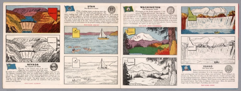
Author
[Fisher, Joseph R., Planters Peanuts (Firm)]
Full Title
Nevada : The sagebrush state -- Utah : The beehive state -- Washington : The evergreen state -- Idaho : The gem state.
List No
14374.015
Note
Four views, representing Nevada, Utah, Washington and Idaho. Views show examples of the landscape and natural resources. Each view includes an inset map of the state, which marks the location of the capital city with a star. Accompanied by descriptive text, the state flags, seals and flowers: sagebrush, sego lily, western rhododendron and syringa, respectively. The view of each state appears both in color (on top) and in black and white (bottom), the latter inviting coloration. Together, views are 18 x 52 cm, on two sheets 20 x 54 cm.
Author
Fremont John Charles, 1813-1890
Full Title
Devil's Gate. (to accompany) Report of The Exploring Expedition to The Rocky Mountains in the Year 1842, and to Oregon & North California In The Years 1843-44. By Brevet Capt. J. C. Fremont ... Washington : Gales and Seaton, Printers. 1845.
List No
13406.009
Note
Lithograph view.
Author
Fremont John Charles, 1813-1890
Full Title
View of the Wind River Mountains. Lith. by E. Weber & Co. Baltimore. (to accompany) Report of The Exploring Expedition to The Rocky Mountains in the Year 1842, and to Oregon & North California In The Years 1843-44. By Brevet Capt. J. C. Fremont ... Washington : Gales and Seaton, Printers. 1845.
List No
13406.010
Note
Lithograph view. Published by E. Weber & Co.
Author
Fremont John Charles, 1813-1890
Full Title
Central Chain of the Wind River Mountain. Lith. by E. Weber & Co. Baltimore. (to accompany) Report of The Exploring Expedition to The Rocky Mountains in the Year 1842, and to Oregon & North California In The Years 1843-44. By Brevet Capt. J. C. Fremont ... Washington : Gales and Seaton, Printers. 1845.
List No
13406.011
Note
Lithograph view. Published by E. Weber & Co.
Author
Fremont John Charles, 1813-1890
Full Title
(Emigrant route in Bear River Valley). Lith. by E. Weber & Co. Baltimore. (to accompany) Report of The Exploring Expedition to The Rocky Mountains in the Year 1842, and to Oregon & North California In The Years 1843-44. By Brevet Capt. J. C. Fremont ... Washington : Gales and Seaton, Printers. 1845.
List No
13406.013
Note
Untitled folded map of emigrant route in Bear River Valley. Relief shown by hachures. Oriented with the north to upper right.
Author
Fremont John Charles, 1813-1890
Full Title
Pass of the Standing Rock. Lith. by E. Weber & Co. (to accompany) Report of The Exploring Expedition to The Rocky Mountains in the Year 1842, and to Oregon & North California In The Years 1843-44. By Brevet Capt. J. C. Fremont ... Washington : Gales and Seaton, Printers. 1845.
List No
13406.015
Note
Lithograph view. Published by E. Weber & Co. Relief shown by hachures.
Author
Fremont John Charles, 1813-1890
Full Title
The Great Salt Lake. Lith. by E. Weber & Co. (to accompany) Report of The Exploring Expedition to The Rocky Mountains in the Year 1842, and to Oregon & North California In The Years 1843-44. By Brevet Capt. J. C. Fremont ... Washington : Gales and Seaton, Printers. 1845.
List No
13406.016
Note
Lithograph map. Published by E. Weber & Co. . Relief shown by hachures.
Author
Geological Survey (U.S.)
Full Title
Central Pacific states.
List No
14359.026
Note
Map representing the Central Pacific States within the United States, as of 1970. Shows political boundaries, cities, railways, roads, ferry lines, Indian reservations, national forests and parks, mountains, mesas, valleys, deserts, bodies of water, drainage, coastlines and islands. Relief shown with labeling of mountain names and peak heights. Features population density for each city. Includes latitudinal and longitudinal lines, bar scale and scale statement. Presented with Albers Equal Area Projection. Colored lithograph. Map is 42 x 68 cm, on double sheet 49 x 71 cm. Index map and legend appear on page 5. Appears in General reference maps section.
Author
[Hayden, Ferdinand Vandeveer, 1829-1887, Russell, Andrew Joseph, 1830-1902]
Full Title
Moore's Lake - head of Bear River, Uintah Mountains. (to accompany) Sun pictures of Rocky Mountain scenery ... by F. V. Hayden, ... New York : Julius Bien, 1870.
List No
13389.003
Note
Black and white view of Moore's Lake at the head of the Bear River in the Uinta Mountains in Utah.
Author
[Hayden, Ferdinand Vandeveer, 1829-1887, Russell, Andrew Joseph, 1830-1902]
Full Title
Sentinel Rock - Echo Canon. (to accompany) Sun pictures of Rocky Mountain scenery ... by F. V. Hayden, ... New York : Julius Bien, 1870.
List No
13389.020
Note
Black and white view, shows rock formations in Echo Canon, Utah.
Author
[Hayden, Ferdinand Vandeveer, 1829-1887, Russell, Andrew Joseph, 1830-1902]
Full Title
Hanging Rock : Echo Canon. (to accompany) Sun pictures of Rocky Mountain scenery ... by F. V. Hayden, ... New York : Julius Bien, 1870.
List No
13389.021
Note
Black and white view, shows rock formations and settlements in Echo Canon, Utah.
Author
[Hayden, Ferdinand Vandeveer, 1829-1887, Russell, Andrew Joseph, 1830-1902]
Full Title
Serrated rocks or Devil's Slide, (Near view) - Weber Cañon, Utah. (to accompany) Sun pictures of Rocky Mountain scenery ... by F. V. Hayden, ... New York : Julius Bien, 1870.
List No
13389.025
Note
Black and white view, shows limestone formations forming a giant chute along the side of the mountain.
Author
[Hayden, Ferdinand Vandeveer, 1829-1887, Russell, Andrew Joseph, 1830-1902]
Full Title
Trestle work : Promontory Point, Salt Lake Valley. (to accompany) Sun pictures of Rocky Mountain scenery ... by F. V. Hayden, ... New York : Julius Bien, 1870.
List No
13389.032
Note
Black and white view, shows Central Pacific Railroad construction at Promontory Point in Salt Lake Valley.
Author
[Berghaus, Heinrich, 1797-1884, Sohr, Karl, Flemming, Carl]
Full Title
Californien, Oregon, Utah und Neu-Mejico. Entw. u. gez. v. F. Handtke. Druck u. Verlag v. C. Flemming in Glogau. (to accompany) Vollstandiger Universal-Handatlas der neueren Erdbeschreibung ,,, Heinrich Berghaus ... 1859.
List No
13250.128
Note
Hand colored in outline map. Includes color coded list of administrative boundaries. Relief shown by hachures. Prime meridians are Paris and Ferro.
Author
Lindgren, Jolly
Full Title
A Hysterical Map of Utah. Which includes Zion. Bryce Canyon. Cedar Breaks & Stinking Spring. Drawn in broken English by Jolly Lindgren. (covers) Jig-saw puzzle hysterical map souvenir entertaining educational fun for everyone. Lindgren-Turner Co. Spokane, WA.
List No
13364.002
Note
Colorful and humorous Jigsaw puzzle.
Author
Union Pacific Railway Company.
Full Title
World's pictorial line : birdseye view of the great Salt Lake Basin reached via the Union Pacific, the overland route. Knight, Leonard & Co., Printers and engravers, Chicago, Ill. Copyrighted. 1893, by E.L. Lomax, General passenger and ticket agent, Union Pacific System, Omaha, Neb.
List No
13206.003
Note
Color pictorial map, on sheet 114 x 45, folded to 23 x 10. Title from cover, with 28 pages of text. On verso 24 pages of text "Sights and scenes in Idaho and Montana", on recto text pages 25-28. Includes logo of "Union Pacific, the overland route" on cover. Map shows major cities, routes, rivers and mountains. Relief shown pictorially.
Author
[United States Bureau of Topographical Engineers, Dougal, W.H.]
Full Title
Old Territory and Military Department of New Mexico : compiled in the Bureau of Topogl. Engrs. of the War Dept. chiefly for military purposes. Under the authority of the Secretary of War 1850. Partially revised and corrected to 1867. Engraved by W. H. Dougal.
List No
11231.000
Note
Uncolored map, published prior to and revised after the Civil War. List of Authorities identifies 19 maps created by explorers of the region published between 1843 and 1858. Shows boundaries, principal travel routes, trails, mail routes, cities and villages, rivers and creeks. Includes list of Principal latitudes & longitudes astronomically determined. Includes notes.
Author
Bancroft, A.L.
Full Title
Bancroft's Map Of California, Nevada, Utah And Arizona. Published By A.L. Bancroft & Compy. Booksellers & Stationers, San Francisco, Cal. 1873. Entered ... by A.L. Bancroft & Company ... Washington, D.C.
List No
0046.000
Note
1st edition was 1864. From Bancroft's Map the of Pacific States which appeared in 1863. Wheat says Bancroft changed the large Pacific States map in 1870, but we believe that the smaller maps such as this continue to be from the original 1863 or 1867 plates, updated to show railroad expansion and topographical changes. With black top and bottom rollers. Full color by county.
Author
[Gunnison, J.W., Preuss, C., Stansbury, Howard]
Full Title
(Covers to maps of the) Exploration and Survey of the Valley of the Great Salt Lake of Utah, including a Reconnoissance of a new Route through the Rocky Mountains. By Howard Stansbury ... Philadelphia: Lippincott, Grambo & Co. 1852.
List No
0950A
Author
[Gunnison, J.W., Preuss, C., Stansbury, Howard]
Full Title
(Title Page to) Exploration and Survey of the Valley of the Great Salt Lake of Utah, including a Reconnoissance of a new Route through the Rocky Mountains. By Howard Stansbury ... (with view) Fort Utah on the Timpanogas - Valley of the Great Salt Lake. Philadelphia: Lippincott, Grambo & Co. 1852.
List No
0950B
Note
Title page with facing view by A. Fay.
Author
[Gunnison, J.W., Preuss, C., Stansbury, Howard]
Full Title
Map of the Great Salt Lake And Adjacent Country in the Territory Of Utah. Surveyed in 1849 and 1850, under the orders of Col. J.J. Abert ... by Capt. Howard Stansbury ... aided by Lieut. J.W. Gunnison ... and Albert Carrington. Drawn By Lieut. Gunnison And Charles Preuss. Ackerman Lith. 379 Broadway N.Y.
List No
0950.001
Note
One of the earliest, and most important government maps of the Great Salt Lake area. Wheat calls this map "a major production...for the Great Salt Lake itself the map was definitive...Scientific cartography for the Territory of Utah may be said to date from the appearance of this map." It is a stunning map, large in scope, and clearly shows the genius of Charles Preuss as a cartographer. Issued in a folder with the large Stansbury "Map of a Reconnoissance between Fort Leavenworth..." Bodies of water have light blue outline color.
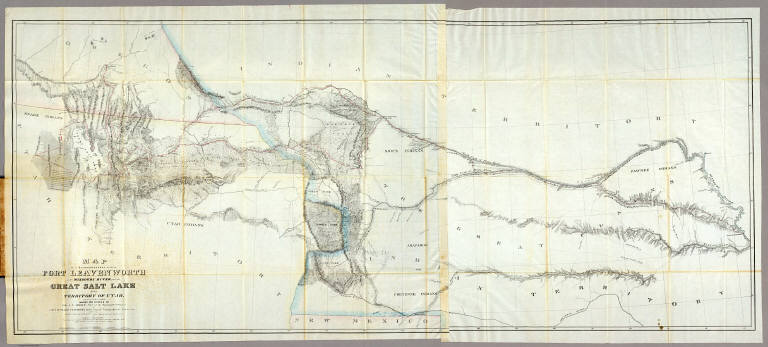
Author
[Gunnison, J.W., Preuss, C., Stansbury, Howard]
Full Title
Map of a Reconnoissance between Fort Leavenworth on the Missouri River, and the Great Salt Lake in the Territory Of Utah, made in 1849 and 1850 under the orders of Col. J.J. Abert ... By Capt. Howard Stansbury ... aided by Lieut. J.W. Gunnison ... and Albert Carrington. The adjacent country laid down from the latest and most authentic data. Drawn by Lieut. Gunnison and Charles Preuss. Ackerman Lith. 379 Broadway N.Y.
List No
0950.002
Note
This is the Fremont/Preuss map of 1845, updated and enlarged, but only going west to the Great Salt Lake. Wheat: "the Stansbury expedition map (is) one of the most important of its decade." Wheat devotes seven pages to this map. It is a major production and is the culmination of the Fremont maps of 1843 and 1845, and the Abert map of 1846. Issued in a folder with the large Stansbury "Map of The Great Salt Lake and Adjacent Country.." With outline color.
Author
Appleton, D. & Co.
Full Title
Map of Utah. Copyright 1891 by Matthews-Northrup Co. ... Buffalo, New York. (to accompany) The Library Atlas Of Modern Geography ... New York, D. Appleton And Company 1892. (on upper margin) Utah 99.
List No
0026.254
Note
Color map. Shows county boundaries, county seat, capital, Indian Reservations, railways, roads, rivers, etc. "Size of type indicates importance of the places". Includes notes. Prime meridians are Greenwich and Washington. Relief shown by hachures.
Author
Arbuckle Bros.
Full Title
Colorado, Utah, Montana, Minnesota. Copyright 1889 Arbuckle Bros. N.Y.
List No
0027.007
Note
Sheet with maps of four states in full color. The Colorado plains are known as a "paradise for invalids" due to the mildness and purity of the atmosphere. Each card measures 7.5 x 12.5 cm.
Author
Asher & Adams
Full Title
Asher & Adams' Utah. Entered according to Act of Congress in the year 1874 by Asher & Adams ... at Washington. (New York, 1874)
List No
0041.032
Note
Hand col. engraved map. Shows townships, distances along railroads, etc. Prime meridians: Greenwich and Washington.
Author
[Bancroft, A.L., Knight, W.H.]
Full Title
(Covers to) Bancroft's Map Of California, Nevada, Utah And Arizona. Published By A.L. Bancroft, & Compy. Booksellers & Stationers San Francisco Cal. 1876. Entered ... by A.L. Bancroft & Company ... Washington, D.C.
List No
0047.001
Note
Additional railroads when compared to the 1873 edition. Full color by county. Folded into dark brown cloth covers 16x11 with title "Bancroft's Map Of California, Nevada, Utah & Arizona." in gold. Relief shown by hachures.
Author
[Bancroft, A.L., Knight, W.H.]
Full Title
Bancroft's Map Of California, Nevada, Utah And Arizona. Published By A.L. Bancroft, & Compy. Booksellers & Stationers San Francisco Cal. 1876. Entered ... by A.L. Bancroft & Company ... Washington, D.C.
List No
0047.002
Note
Additional railroads when compared to the 1873 edition. Full color by county. Folded into dark brown cloth covers 16x11 with title "Bancroft's Map Of California, Nevada, Utah & Arizona." in gold. Relief shown by hachures.
Author
Colton, G.W.
Full Title
Territories Of New Mexico and Utah. Published By J.H. Colton & Co. No. 172 William St. New York. Entered ... 1855 by J.H. Colton & Co. ... New York. No. 51.
List No
0149.056
Note
In full color by county. Utah extends from the Rocky Mountains in the east to the California border in the west. New Mexico stretches from the Texas border to the California border. Routes shown for possible railway extensions. Routes of explorers such as Fremont and Gunnison are shown.
Author
Colton, G.W.
Full Title
Colton's Map of California, Nevada, Utah, Colorado, Arizona & New Mexico. Published By J. H. Colton. No. 172 William St. New York.
List No
0151.062
Note
Shows routes, dates of exploration and the explorers. Prime meridians are Greenwich and Washington D.C. Relief shown by hachures
Author
Colton, G.W.
Full Title
Colton's Map of California, Nevada, Utah, Colorado, Arizona and New Mexico. Published By G. W & C. B. Colton & Co. No. 172 William St. New York.
List No
0152.064
Note
Prime meridians are Washington D.C. and Greenwich.
Author
Cram, George Franklin
Full Title
Utah.
List No
0210.051
Note
Prime meridians Greenwich and Washington.
Author
Gray, O.W.
Full Title
Gray's Atlas Map of Utah. 1873.
List No
0310.075
Author
[Gray, Frank A., Gray, O.W.]
Full Title
Gray's New Map of Utah by Frank A. Gray.
List No
0312.054
Author
Johnson, A.J.
Full Title
Johnson's California, With Territories of Utah, Nevada, Colorado, New Mexico And Arizona,Published By Johnson and Ward. Entered ... 1864, by A.J. Johnson ... New York.
List No
0352.044
Note
Full color by counties, with heavy outlines around the states. detail mining districts, political divisions, emigrant trails, the Santa Fe Trail, the Pony Express Route, several proposed Union Pacific railroads, and Indian tribes and territories. This important map went through several different states during its publication period from 1860 to 1870. This critical period in westward expansion saw incredible development and change throughout the region. This, the 1864 Johnson and Ward version represents a complete re-engraving of the 1862-1863 map. Johnson added considerable detail in the mountainous regions of California, Nevada and Colorado. Arizona and New Mexico appear as independent territories but shows the old "New Mexico" county structure. The southern boundary of Nevada with Arizona is set at 37 degrees of Latitude such that Las Vegas, shown within Arizona. Relief shown by hachures. Prime meridians are Greenwich and Washington D.C.
Author
Johnson, A.J.
Full Title
Johnson's California also Utah, Nevada, Colorado, New Mexico, and Arizona. Entered ... 1864.
List No
0358.049
Author
King, Clarence
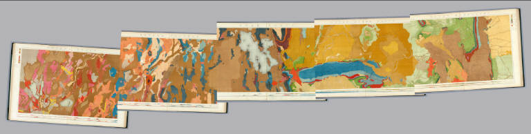
Full Title
(Covers to) Engineer Department U.S.A. Geological and Topographical Atlas Accompanying the Report of the Geological Exploration of the Fortieth Parallel Made by the Authority of the Honorable Secretary of War under the direction of Brig. and Brvt. Major General A.A. Humphreys, Chief of Engineers U.S.A. by Clarence King, U.S. Geologist in Charge, 1876. Julius Bien Lith.
List No
0408A
Author
King, Clarence
Full Title
(Title Page to) Engineer Department U.S.A. Geological and Topographical Atlas Accompanying the Report of the Geological Exploration of the Fortieth Parallel Made by the Authority of the Honorable Secretary of War under the direction of Brig. and Brvt. Major General A.A. Humphreys, Chief of Engineers U.S.A. by Clarence King, U.S. Geologist in Charge, 1876. Julius Bien Lith.
List No
0408B
Note
Magnificent, huge atlas showing the area of the 40th Parallel Survey in topographical and geological maps. Wheat notes: "These are pioneer survey maps, and as such are most interesting. Mapping the West in so broad a cross-section had never before been attempted, a portent of things to come." King, at the age of 25, was made Geologist-in-charge of the Survey in 1867. He was formally ordered "to examine and describe the geological structure, geographical condition and natural resources of a belt of country extending from the 120th meridian eastward to the 105th meridian, along the 40th parallel of latitude with sufficient expansion north and south to include the lines of 'Central' and 'Union Pacific' railroads..." (Wheat). The topographical sheets depict features by brush shading rather than hachuring. In original binding -rare. Bound in green half leather with a label on the front, "Geological and Topographical Atlas Accompanying the Report of the Geological Exploration of the Fortieth Parallel. Clarence King, Geologist in Charge."
Author
King, Clarence
Full Title
(Index Page to) Engineer Department U.S.A. Geological and Topographical Atlas Accompanying the Report of the Geological Exploration of the Fortieth Parallel Made by the Authority of the Honorable Secretary of War under the direction of Brig. and Brvt. Major General A.A. Humphreys, Chief of Engineers U.S.A. by Clarence King, U.S. Geologist in Charge, 1876. Julius Bien Lith.
List No
0408C
Note
Index page includes the list of maps and a legend naming the mapmakers and the basis by which the maps were made.
Author
King, Clarence
Full Title
Green River Basin. Map II. (Geological)
List No
0408.003
Note
Map in full color with the legends on either side of the maps. Map extends from Fortification Peak in Wyoming to Piedmont in Utah. Below the map are two geologic cross sections.
Author
King, Clarence
Full Title
Utah Basin. Map III. (Geological)
List No
0408.004
Note
Map in full color with the legends on either side of the maps. Map extends from Piedmont in Utah to Bovine, Utah including the Great Salt Lake. Below the map are two geologic cross sections.
Author
King, Clarence
Full Title
(Composite of) Geological Maps I-V, 40th Parallel Survey.
List No
0408.007
Note
Maps in full color with the legends on either side of the maps.
Author
King, Clarence
Full Title
General Sections.
List No
0408.008
Note
In full color. Ten sections shown with the legends on either side of the cross sections.
Author
King, Clarence
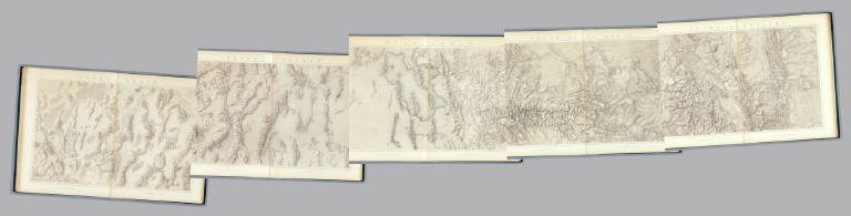
Full Title
Green River Basin. Map II. (Topographical)
List No
0408.010
Note
Map in brown shaded relief. Map extends from Fortification Peak in Wyoming to Piedmont in Utah.
Author
King, Clarence
Full Title
Utah Basin. Map III. (Topographical)
List No
0408.011
Note
Map in brown shaded relief. Map extends from Piedmont in Utah to Bovine, Utah including the Great Salt Lake.
Author
King, Clarence
Full Title
Nevada Plateau. Map IV. (Topographical)
List No
0408.012
Note
Map in brown shaded relief. Map extends from Bovine, Utah across the Nevada plateau to Argenta, Nevada.
Author
King, Clarence
Full Title
(Composite of) Topographical Maps I-V, 40th Parallel Survey.
List No
0408.014
Note
Maps in brown shaded relief.
Author
Leahy, J.F.
Full Title
(Index to) Leahy's Hotel Guide and Railway Distance Maps. Texas. Utah.
List No
0425.118
Note
Texas and Utah alphabetical index list of the Hotels of the town with the number of rooms of each, their rates per day and the population of the town. Includes population of the states, Explanation of abbreviation of the railroad of the state, and advertisement.
Author
Leahy, J.F.
Full Title
Leahy's Hotel Guide and Railway Distance Map of the State of Utah. Published by American Hotel Register Company. Leahy Build., 228-234 W. Ontario St., Chicago, Ill. Copyrighted by J.F. Leahy, Jan., 1934.
List No
0425.119
Note
Map printed without color. Includes name of the railroad entering the town, and distance between towns.
Author
Johnson, A.J.
Full Title
Johnson's California, With Utah, Nevada, Colorado, New Mexico And Arizona Published By Johnson and Ward.
List No
0535.041
Note
In full color. Various routes shown: Proposed Central Pacific Railroad, Proposed Union Pacific Railroad, Pacific Railroad, Pony Express, Emigrant Road, Simpson 1859, Fremont 1845, Fremont 1844, Fremont 1843, Spanish Trail from Los Angeles to Albiguia New Mexico, Spainish Trail from Salt Lake to Santa Fe, Captain Gunnison 1855, Captain Sitgreaves 1951, Major Emory 1846, El Paso Waggon (Wagon) Road, Cimarron Route to Fort Leavenworth, Colonel Washington, etc. Delineates various Indian lands. Shows Head of Navigation on the Colorado River at the confluence with the Virgin River. Relief shown by hachures. Meridians Greenwich and Washington D.C.
|