|
Author
[Ptolemy, Claudius, Gastaldi, Giacomo, Mattioli, Pietro Andrea, 1500-1577, Pedrezano, Giovanbattista]
Full Title
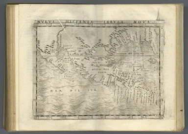
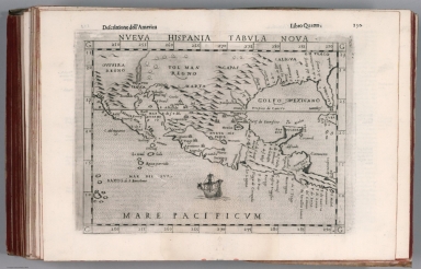
Nueva Hispania tabula nova. (to accompany) Ptolemeo. La geografia di Claudio Ptolemeo alessandrino ... In Venetia, ... per Gioan. Baptista Pedrezano ... Anni x. M.D.XLVIII (1548).
List No
11479.121
Note
Engraved new map of the Southern half of the United States, Mexico and Central America. Shows present-day Mexico, Florida, Texas and one of the earliest depiction of California as a Peninsula on a printed map. In the vicinity of the Colorado River flows the R. Tontonteanc and the Yucatan appears as an island. The place names reflect the explorations of Pineda, Cabeza de Vaca, and Moscosso. Map shows settlements, towns, landmarks, rivers and mountains. Relief shown pictorially.
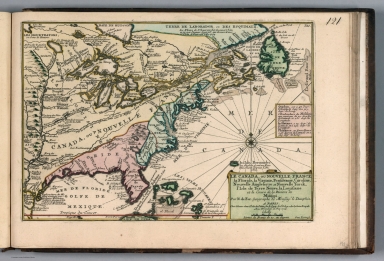
Author
[Ptolemy, Claudius, Gastaldi, Giacomo, Mattioli, Pietro Andrea, 1500-1577, Pedrezano, Giovanbattista]
Full Title
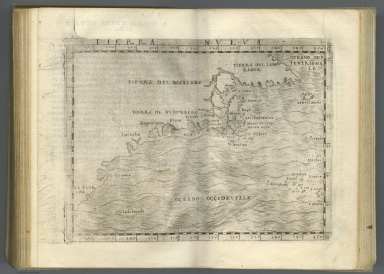
Tierra Nueva. (to accompany) Ptolemeo. La geografia di Claudio Ptolemeo alessandrino ... In Venetia, ... per Gioan. Baptista Pedrezano ... Anni x. M.D.XLVIII (1548).
List No
11479.123
Note
First map of the North American East Coast, and the first map largely devoted to Canada. The map extends from Labrador to Florida. Discoveries reported by Giovanni di Verrazano (1524)and Jacques Cartier's 1st voyage (1534). Several place names used in the map for the first time, are still in use today, including Larcadia (Acadia), Breton (Cape Breton Island), and Labrador. Tierra del Bacalaos, noted by Verrazzano the land of Bacalaia. Tierra de Nurumberg for New England was discovered by Verrazanothe in 1524 voyage, which included ''Larcadia'' (part of North Carolina's coast); Angoulesme (New York Harbor); Flora (south coast of Long Island); and Narragansett Bay. Map shows place names.
Author
[Ptolemy, Claudius, Ruscelli, Girolamo, Giuseppe Moletti, M.]
Full Title
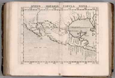
Nveva Hispania tabvla nova. Nveva Hispania, Trentesimaprima tavola nvova. (To accompany) La geografia di Claudio Tolomeo Alessandrino, nuouamente tradotta di Greco in Italiano, da Girolamo Ruscelli ... In Venetia, Appresso Vincenzo Valgrisi, M.D.LXI. (1561).
List No
11311.125
Note
Engraved map of New Spain. Showing Mexico and Central America, the southern United States, including Florida. California is a peninsula and in the vicinity of the Colorado River flows the R. Tontonteanc, showing Sier Anevada (Sierra Nevada). Relief shown pictorially.
Author
Monte (Monti), Urbano, 1544-1613
Full Title
Tavola XI Che Ha Sua Superiore La Tavola Quarta. Libro Terzo.
List No
10130.013
Author
[Ptolemy, Claudius, Ruscelli,Girolamo, Rosaccio, Giuseppe]
Full Title
Nveva Hispania tabvla nova. Descrittione dell'America. Libro Quarto. (to accompany) Geographia di Clavdio Tolomeo alessandrino, tradotta di Greco nell'idioma volgare Italiano da Girolamo Ruscelli ... In Venetia, MDXCIX (1599) Appresso gli heredi di M. Sessa.
List No
11299.068
Note
Engraved map of New Spain. Showing the southern United States, including Texas and Florida and Mexico and Central America. California is a peninsula and in the vicinity of the Colorado River flows the R. Tontonteanc, with place names, showing Sier Anevada (Sierra Nevada). Relief shown pictorially.
Author
[Mercator, Gerhard, 1512-1594, Hondius, Jodocus, 1563-1612, Hondius, Hendrik, 1597-1651]
Full Title
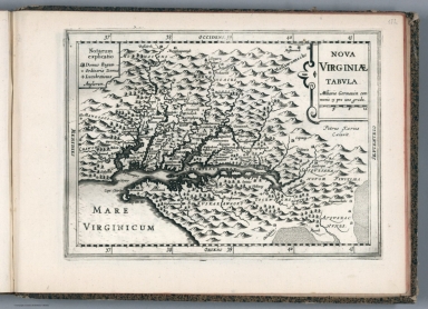
Nova Yirginiae Tabula Amstelodami, ex officina Henrici Hondii.
List No
10621.197
Note
Inset: Status Regis Powhatan quando praefectus Smith Captivus i!Ji daretur (Picture). 10 x 8 cm.
Author
[Janssonius van Waesberge, Johannes, Kaerius, Petrus, Mercator, Gerhard, 1512-1594, Cloppenburg, Johannes, 1592-1652]
Full Title
Nova Virginiae tabula. Petrus Kaerius Caelavit. (to accompany) Atlas sive Cosmographicae Meditationes de Fabrica mundi et fabricati figura. De novo multis in locis emendatus novisque tabulis auctus. Amsterodami, apud Iohannem Ianssonium van Waesberge. Anno, 1673.
List No
11487.176
Note
Copper engraved map of Virginia, showing Chesapeake Bay regionand the surrounding environs. Shows towns, villages, landmarks, mountains, Indian Tribes, and rivers. Relief shown pictorially. Includes explanations.
Author
[Janssonius van Waesberge, Johannes, Mercator, Gerhard, 1512-1594, Cloppenburg, Johannes, 1592-1652]
Full Title
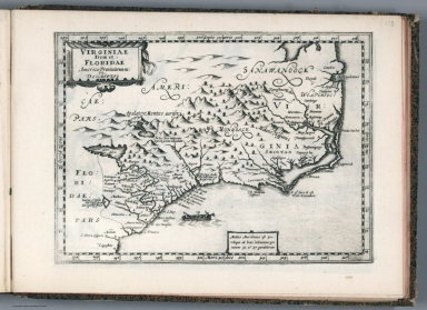
Virginiae item et Floridae Americae Provinciarum, nova descriptio. (to accompany) Atlas sive Cosmographicae Meditationes de Fabrica mundi et fabricati figura. De novo multis in locis emendatus novisque tabulis auctus. Amsterodami, apud Iohannem Ianssonium van Waesberge. Anno, 1673.
List No
11487.177
Note
Copper engraved map of the southeastern part of North America, covers Virginia and Florida. Cover the coast from Chesapeake Bay to St. Augustine. Shows towns, villages, mountains, Indian settlement, and rivers. Relief shown pictorially. Includes notes.
Author
[Sanson, Nicolas, 1600-1667, Sanson, Guillaume (1633-1703)]
Full Title
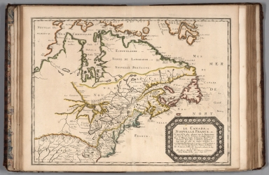
Le Canada ou Nouvelle France. (Canada or New France.)
List No
9741.136
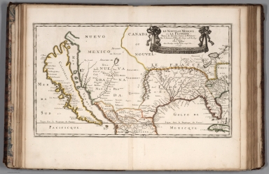
Author
[Sanson, Nicolas, 1600-1667, Sanson, Guillaume (1633-1703)]
Full Title
Le Nouveau Mexique et la Floride (New Mexico and Florida).
List No
9741.137
Author
[Jaillot, Alexis Hubert, 1632?-1712, Mortier, Pierre, Sanson, Nicolas, 1600-1667]
Full Title
L'Amerique Angloise.
List No
12178.215
Author
[Jaillot, Alexis Hubert, 1632?-1712, Mortier, Pierre, Sanson, Nicolas, 1600-1667]
Full Title
Le Canada.
List No
12178.220
Author
Aa, Pieter van der, 1659-1733
Full Title
L'Amerique septentrionale, Suivant les nouvelles observations de Messrs ... A Leide, Chez Pierre Van der Aa. (to accompany) Nouvel Atlas, tres-exact et fort commode pour toutes sortes de personnes, Contenant les Principales Cartes Geographiques ...
List No
11691.101
Note
Full color map of North America and the West Indies. Centered on the Great lakes, covers from Baffin Bay to the Amerique Meridionale, including Florida, New Mexico, New Spain (Mexico), California, Nouvelle France, and the Hudson Bay. California is not clear whether it is an island or not. The Gulf of California is left open ended, Parts of California are identified as New Albion. The exploration routes used by d'Oliver, Cortez, and Drake are shown in dote lines to the west of Mexico. Map showing political and administrative boundaries and settlements. Relief shown pictorially. Includes decorative title cartouche.
Author
Aa, Pieter van der, 1659-1733
Full Title
La Floride, Suivant les nouvelles observations de Messrs ... A Leide, Chez Pierre Van der Aa. (to accompany) Nouvel Atlas, tres-exact et fort commode pour toutes sortes de personnes, Contenant les Principales Cartes Geographiques ...
List No
11691.102
Note
Full color map of Southern States. Covers part of Mexico, New Mexico, Texas, and Florida as far North as Illinois and Philadelphia, includes also the Carolinas, Virgina and Maryland. Map showing political and administrative boundaries, Native American settlements, major towns and villages. Relief shown pictorially. Includes decorative title cartouche.
Author
Homann, Johann Baptist, 1663-1724
Full Title
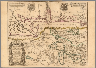
Mississippi.
List No
12499.224
Author
Fer, Nicolas de, 1646-1720
Full Title
Le Canada, ou Nouvelle France.
List No
12201.132
Author
[Chatelain Henri, 1684-1743, Gueudeville, Nicolas]
Full Title
Carte de la Nouvelle France, ou se voit le cours des grandes rivieres de S. Laurens & de Mississipi aujour d'hui S. Louis, aux environs des-quelles se trouvent les etats, païs, nations, peuples &c. de la Floride, de la Louisiane, de la Virginie, de la Marie-Lande, de la Pensilvanie, du Nouveau Jersay, de la Nouvelle Yorck, de la Nouv. Angleterre, de l'Acadie, du Canada, des Esquimaux, des Hurons, des Iroquois, des Ilinois &c. et de la grande ile de Terre Neuve : dressee sur les memoires les plus nouveaux recueillis pour l'etablissement de la Compagnie Françoise Occident. Tom. VI. No. 23. Page 90. (to accompany) Atlas Historique ... Tome VI. A Amsterdam, chez L'Honore & Chatelain Libraires. M DCC XIX (1719).
List No
13272.687
Note
Engraved folded map, depiction of the Mississippi Delta and Mobile Bay, based upon the 1699 voyage of Pierre Le Moyne d'Iberville. Shows New England and eastern Canada. Includes plan and views of Quebec in decorative cartouche. Map is filled with engraved wildlife, scenes of Indians hunting, Indian villages, numerous ships, canoes and sea monsters and notations.
Author
[Chatelain Henri, 1684-1743, Gueudeville, Nicolas]
Full Title
Carte Contenant le Royaume du Mexique et la Floride dressez sur les meilleures observations & sur les memoires les plus nouveaux. Tom. VI. No. 27. Pag. 101. (to accompany) Atlas Historique ... Tome VI. A Amsterdam, chez L'Honore & Chatelain Libraires. M DCC XIX (1719).
List No
13272.698
Note
Engraved map of North America and the West Indies, from Newfoundland and the Great Lakes to northern South America, based on de L'Isle's map of the southern part of North America. Covers New Mexico, Louisiana, from Florida through present-day Texas and the Gulf Coast region. Shows political boundaries, Indian settlements, cities, towns, ports, rivers, and notes the discoveries along the Gulf Coast and Mississippi River. Includes text. Relief shown pictorially.
Author
[Seutter, Matthaeus, 1678-1756, Rogg, Gottfried, 1669-1742]
Full Title
Accurata delineatio celeberrimae Regionis Ludovicianae vel Gallice Louisiane ol. Canadae et Floridae Adpellatione in Septemtrionali America Descriptae quae Hodie Nomine Fluminis Mississippi vel St. Louis . . . edita cura et manu Matthaei Seutteri, Chalcog. Augustan. ; Gottfr. Rogg, del. M. Rhein, sc.(inset) "Les costes de la Louisiane depuis la baye de Ascension jusques acelle de S. Joseph.
List No
8155.000
Note
Hand colored map of Seutter's Mississippi Bubble map, depicting the short-lived French financial-colonial scheme masterminded by Scottish financier John Law. Map shows early eighteenth century geography, settlements, and territories in North America focusing on the Mississippi River and the Great Lakes. Relief shown pictorially. Includes historical notes and distant chart. A large inset of the Gulf Coast shows many forts and Indian villages. Elaborate title cartouche, depicts an allegorical, satirical scene of the infamous Mississippi Bubble investment scheme with a female personification of the Mississippi River pouring jewels and riches forth, while she is perched precariously upon a bubble. Cherubs above the cartouche are issuing stock for the company, and another group is blowing bubbles in the foreground surrounded by piles of worthless stocks. In the background, desperate investors climb a small tree and fling themselves out of it, and in the foreground more disconsolate investors wail and bemoan their fates as one tries to impale himself on his sword. Above them, a cherub upends an empty money-bag.
Author
[Chatelain Henri, 1684-1743, Gueudeville, Nicolas]
Full Title
Carte Particuliere Du Fleuve Saint Louis : Dressee Sur Les Lieux Avec Les Noms Des Sauvages Du Pais... Tom. VI. No. 21. Pag. 90. (to accompany) Atlas Historique ... Tome VI. A Amsterdam, chez L'Honore & Chatelain Libraires. M DCC XIX (1719). .
List No
13272.685
Note
Engraved map covers the area of South Hudson Bay and concentrates on the Great Lakes and the Course of the Mississippi, extending south to the Missouri River. The St. Laurent is shown running into the Great Lakes from present day Lake Winnipeg. Georgian Bay is named "Baye de Toronto. Map depicts French missions, forts, and French and Indian settlements, waterways and portages. Includes lists of the birds, fish, plants, and insects of Canada, and the list of Indian tribes of the different regions and various trade goods.
Author
[Chatelain Henri, 1684-1743, Gueudeville, Nicolas]
Full Title
Description de la peche, habillemens, habitations, manieres de vivre, superstitions et autres usages des Indiens de la Virginie; le tout fidellement extrait des mémoires et des desseins qui en out ete tirez sur les lieux. Tom. VI. No. 25. Pag. 100. (to accompany) Atlas Historique ... Tome VI. A Amsterdam, chez L'Honore & Chatelain Libraires. M DCC XIX (1719).
List No
13272.696
Note
Engraved views and description of native American way of life in Virginia. Including worshipping, burial practices and ceremonies, farming, hunting, villages and costumes. The descriptions and illustrations are taken from Theodor de Bry's America.
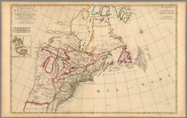
Author
Senex, John (c.1678-1740)
Full Title
A New Map of the English Empire in America.
List No
10014.254
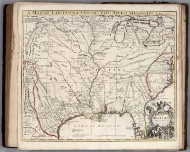
Author
Senex, John (c.1678-1740)
Full Title
A Map of Louisiana and of the River Mississippi.
List No
10014.266
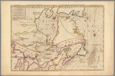
Author
L'Isle, Guillaume de, 1675-1726
Full Title
Carte du Canada ou de la Nouvelle France et des decouvertes que y ont ete faites. Dressee sur plusieurs observations et sur un grand nombre de relations imprimees ou manuscrites. Par Guillaume Del'Isle, Geographe de l'Academie Royale des Sciences. A Paris, chez l'Auteur sur le Quai de l'Horloge al Aigle d'Or, avec Privilege du sa Maj. pour 20 ans, 1703 (between 1708 and 1712?).
List No
4764.097
Note
Engraved map in outline color. Shows forested areas. Relief shown pictorially. Covers eastern Canada and the United States south to 39 degrees N. Fourth state, with imprint of L. Renard Libraire and name of cartouche engraver N. Guerard erased from engraving plate. Reproduced in the "Labrador Boundary Canadian Atlas." Incorporates Lahontan's imaginary features including the Pays des Gnacsitares and the Riviere Morte.
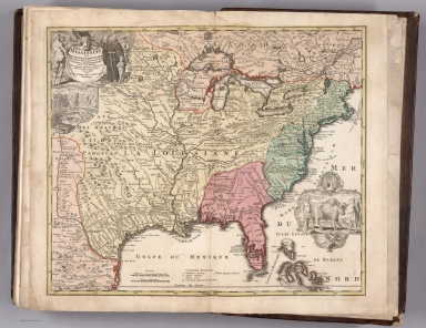
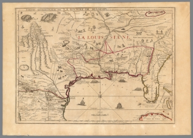
Author
L'Isle, Guillaume de, 1675-1726
Full Title
Carte de la Louisiane et du Cours du Mississipi. Dressee sur un grand nombre de Memoires en trautres sur ceux de Mr. le Maire. Par Guillaume Delisle de l'Academie Rle. des Sciences. A Paris, chez l'Auteur le Sr. Delisle sur le Quay de l'Horloge, avec Privilege du Roy Juin 1718.
List No
4764.098
Note
Engraved map in outline color. Shows Indian villages, "nations derangees, nations detruites," the route of de Soto, Moscoso, Cavelier, Tonty and Denis, etc. Relief shown pictorially. Covers area from Lake Champlain to New Mexico and south to Florida and Texas. Inset map: Carte particuliere des embouchures de la Rivie. S. Louis et de la Mobile, i.e., Mississippi Delta area and Mobile Bay. Kohl states this is the mother and main source of all later maps of the Mississippi.
Author
L'Isle, Guillaume de, 1675-1726
Full Title
Carte du Mexique et de la Floride, des Terres Angloises et des Isles Antilles, du cours et des environs de la Riviere de Mississipi. Dressee sur un grand nombre de memoires principalemt. sur ceux de Mrs. d'Iberville et le Sueur. Par Guillaume Del'Isle, Geographe de l'Academie Royale des Sciences. A Paris, chez l'Auteur sur le Quai de l'Horloge, (avec) Privilege du Roy po. 20. ans, 1703 (1708 or later)
List No
4764.099
Note
Engraved map in outline color. Shows Indian villages, etc. Relief shown pictorially. Covers area from the Great Lakes to Colombia and from the Gulf of California to Trinidad. "It was the first printed map to portray accurately the course and mouth of the Mississippi River," Martin. Title cartouche by "C. Simonneau, fecit." Imprint of L. Renard Libraire has been erased from engraving plate.
Author
Moll, Herman, d. 1732
Full Title
A New and Exact Map of the Dominions of the King of Great Britain on ye Continent of North America. (insets) Carolina, Louisiana, Florida. Carolina. Charles-town. North America. Beaver activity illustration.
List No
9729.010
Note
State 6 of this map. Known as the "Beaver map" because of its depiction of beavers at work building dams with Niagara Falls in the background. This map at the time was the most detailed and largest scale map of British possessions in North America. First issued in 1715, the map went through 7 different issues to 1736.
Author
Moll, Herman, d. 1732
Full Title
A new map of ye north parts of America, claimed by France under ye names of Louisiana, Mississipi, Canada & New France, with the adjoyning territories of England & Spain. By H. Moll Geographer. (Printed and sold by T. Bowles next ye Chapter House in St. Pauls Church yard, & I. Bowles at ye Black Horse in Cornhill, 1736?)
List No
5580.046
Note
Hand col. engraved map. Relief shown pictorially.
Author
[Covens et Mortier, L'Isle, Guillaume de, 1675-1726]
Full Title
Carte du Canada ou de la Nouvelle France et des decouvertes que y ont ete faites. Dressee sur plusieurs observations et sur un grand nombre de relations imprimees ou manuscrites. Par Guillaume Del'Isle, Geographe de l'Academie Royale des Sciences. A Amsterdam, Chez Jean Covens et Corneille Mortier, Geographes. Avec privilege. (1742)
List No
4638.094
Note
Engraved map in outline color. Shows forested areas. Relief shown pictorially. Covers eastern Canada and the United States south to 39 degrees N. Incorporates Lahontan's imaginary features including the Pays des Gnacsitares and the Riviere Morte.
Author
[Covens et Mortier, L'Isle, Guillaume de, 1675-1726]
Full Title
Carte de la Louisiane et du Cours du Mississipi. Dressee sur un grand nombre de memoires entr'autres sur ceux de Mr. le Maire. Par Guillme. de l'Isle de l'Academie Rle. des Sciences. A Amsterdam, Chez Jean Covens et Corneille Mortier, Geographes. (1742)
List No
4638.095
Note
Engraved map in outline color. Shows Indian villages, "nations derangees, nations detruites," the routes of de Soto, Moscoso, Cavelier, Tonty and Denis, etc. Relief shown pictorially. Covers area from Lake Champlain to New Mexico and south to Florida and Texas. Inset map: Carte particuliere des embouchures de la Riviere S. Louis et de la Mobile (i.e., Mississippi Delta area and Mobile Bay). Kohl states this is the mother and main source of all later maps of the Mississippi.
Author
[Covens et Mortier, L'Isle, Guillaume de, 1675-1726]
Full Title
Carte du Mexique et de la Floride, des Terres Angloises et des Isles Antilles, du cours et des environs de la Riviere de Mississipi. Dressee sur un grand nombre de memoires principalement sur ceux de Mrs. d'Iberville et le Sueur. Par Guillaume Del'Isle, Geographe de l'Academie Royale des Sciences. A Amsterdam, Chez Jean Covens & Corneille Mortier. Avec privilege. I. Stemmers Senior sculp. (Title in upper margin:) Tabula geographica Mexicae et Floridae &c. 1722.
List No
4638.096
Note
Engraved map in outline color. Shows Indian villages, etc. Relief shown pictorially. Covers area from the Great Lakes to Colombia and from the Gulf of California to Trinidad. "It was the first printed map to portray accurately the course and mouth of the Mississippi River," Martin.
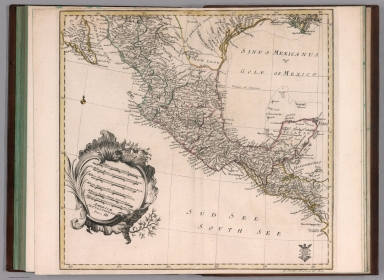
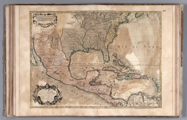
Author
Bowen, Emanuel
Full Title
A new & accurate map of Mexico or New Spain together with California, New Mexico &c. Drawn from the best modern maps & charts & regulated by astronl. observns. By Eman: Bowen. (London: Printed for William Innys, Richard Ware, Aaron Ward, J. and P. Knapton, John Clarke, T. Longman and T. Shewell, Thomas Osborne, Henry Whitridge ... M.DCC.XLVII)
List No
3733.057
Note
Engraved map. Shows shoals, etc. Includes historical note on California and ornamental cartouche. Relief shown pictorially. Inset map: The Gallipago Islands : discovered & described by Capt. Cowley in 1684. Scale [ca. 1:5,000,000]
Author
Bowen, Emanuel
Full Title
A new & accurate map of Louisiana, with part of Florida and Canada, and the adjacent countries. Drawn from surveys, assisted by the most approved English & French maps & charts. The whole being regulated by astronomical observations. By Eman. Bowen. (London: Printed for William Innys, Richard Ware, Aaron Ward, J. and P. Knapton, John Clarke, T. Longman and T. Shewell, Thomas Osborne, Henry Whitridge ... M.DCC.XLVII)
List No
3733.058
Note
Engraved map. Includes geographical note and ornamental cartouche. Relief shown pictorially.
Author
[Fer, Nicolas de, 1646-1720, Compagnie des Indes occidentales]
Full Title
Partie meridionale de la Riviere de Missisipi et ses environs dans l'Amerique Septentrionale.
List No
10022.099
Note
This is also the lower half of a two sheet map. The top half is our 10022.100 - "Le Cours du Missisipi ou de St. Louis."
Author
[Fer, Nicolas de, 1646-1720, Compagnie des Indes occidentales]
Full Title
Le cours de Missisipi, ou de St. Louis : fameuse riviere de l'Amerique Septentrionale aux environs de laquelle se trouve le pai��s appelle Louisiane : dresse��e sur les relations et me��moires du pere Hannepin et de mrs. de La Salle, Tonti, Laotan, Ioustel, Des Hayes, Joliet, et Le Maire &c. (inset map)
List No
10022.100
Note
This map joins with our 10022.099 - "Partie meridionale de la Riviere de Missisipi.This is also the lower half of a two sheet map. The top half is our 10022.100 - "Le Cours du Missisipi ou de St. Louis." Shows the source of the Mississippi River, with latitude and longitude coordinates; covers east to Lake Ontario and south to Illinois. Scattered throughout are images of Native villages, and Natives hunting game and participating in a ritual. The inset map depicts the final section of this river, emptying into the Gulf of Mexico near what is now New Orleans. The decorative border dividing the two maps features Natives with bows and arrows, as well as reindeer. In the lower left corner, surrounding the map's title, are images of monks preaching to and baptizing Natives, Natives hunting, and a Native holding a scalp
Author
[Fer, Nicolas de, 1646-1720, Compagnie des Indes occidentales]
Full Title
(Composite map of) Le cours de Missisipi, ou de St. Louis (with) Partie meridionale de la Riviere de Missisipi.
List No
10022.101
Note
A composite of two maps that De Fer published separately but also appeared joined together to show the entire course of the Mississippi River. From Ruderman: "De Fer's 2 sheet map is one of the most important maps of the region and one of the earliest maps to incorporate the reports of Jesuit missionaries and explorers active in the early 18th Century. De Fer's map is perhaps the most important and influential regional map of the period, providing significantly updated cartographic information in a number of regions. The map is the first printed map to provide the updated treatment of the Mississippi River later made famous by De L'Isle in his Carte de la Louisiane et du cours du Missisipi. . . (pre-dating De L'Isle's map) , the first to include the updated information along the Gulf Coast transmitted to France by Francoise Le Maire and the first to incorporate the revised and improved mapping of the Great Lakes derived from Jesuit missionary sources in the north. While its cartographic details rival the contemporary maps of Guillaume De L'Isle for primacy, De Fer's map was almost certainly the more influential work at the time it was published, having been commissioned by John Law's Compagnie d'Occident (Company of the West), to provide a graphic depiction of the vast and rich commercial potential of French Louisiana, for which commercial rights had just been ceded to Law's Company of the West. De Fer first began work on his map in 1715, when he issued his La Riviere de Missisipi, et ses Environs, dans l'Amerique Septentrionale ..., based upon a 1701 manuscript map by Guillaume De L'Isle . The 1715 map is essentially the proof state for the lower half of the 2-sheet map, lacking the internal embellishments intended to demonstrate the wealth of the region. With the founding of John Law's Company of the West and Law's being granted by the King of France the rights to commercial control of Louisiana in August 1717, Law commenced an advertising and promotional campaign to attract investors for his new company. A visual tool was undoubtedly needed to help potential investors understand the scope and commercial potential of France's holdings in Louisiana. To fill the need, De Fer was commissioned to create such a map.
Author
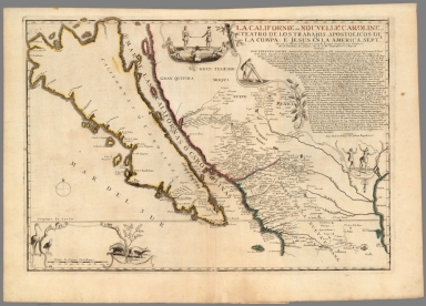
Fer, Nicolas de, 1646-1720
Full Title
La Californie ou Nouvelle Caroline, teatro de los trabajos, apostolicos de la Compa. e Jesus en la America Septe. : Dresse��e sur celle que la viceroy de la Nouvelle Espagne envoya ily a peu d'anne��es a mrs. de l'Acade��mie des Sciences
List No
10022.102
Note
Shows California as an island.
Author
Bröuckner, Isaak, 1686-1762.
Full Title
Carte marine entre Californie et une partie de l'Asie la plus orientale. 1749. (to accompany) Nouvel Atlas De Marine... Par Isaac Brouckner ... Approuve par l’ academie Royale des Sciences a Berlin l’ Annee 1749.
List No
13388.009
Note
Hand colored in outline nautical chart between California and part of eastern Asia.
Author
Euler, Leonhard, 1707-1783
Full Title
Americae septentrionalis pars III. (to accompany) Atlas geographicus omnes orbis terrarum regiones = Atlas geographique representant en XLI cartes toutes les regions de la terre ... Berolini : Ex officina Michaelis MDCCLIII (1753).
List No
11392.052
Note
Part 3 of 4 part map of North America. Hand colored copperplate engraving map on 2 sheets. Covers the region from the Gulf Coast of the U.S. through Mexico to Honduras. Showing geographic features, rivers, lakes, mountains, cities, and principal towns. Relief shown pictorially. In lower right corner: 5. Novell America 3. theil.
Author
Seutter, Matthaeus, 1678-1756
Full Title
41. Accurata delineatio celeberrimae Regionis Ludoviciane vel Gallice Louisiana ... Florida ... Mississippi. (inset) Les Costes de la Louisiane Depuis la Baye de Ascension.
List No
12040.106
Note
Date estimated.
Author
Seutter, Matthaeus, 1678-1756
Full Title
43. Recens Edita totius Novi Belgii, in America Septentrionali.
List No
12040.108
Note
Date estimated.
Author
[Robert de Vaugondy, Didier, 1723-1786, Robert de Vaugondy, Gilles, 1688-1766]
Full Title
Partie de l'Amerique Septentrionale, qui comprend le Cours de l'Ohio, la Nlle. Angleterre, la Nlle. York, le New Jersey, la Pensylvanie, le Maryland, la Virginie, la Caroline. Par le Sr. Robert de Vaugondy Geographe ordinaire du Roi. Avec Privilege 1755. M.C. Haussard fecit. (with) Supplement pour la Caroline.
List No
3353.100
Note
Engraved map. Hand col. borders. Relief shown pictorially. Ornamental cartouche. Shows missions, forts, Native American tribes and villages, etc.
Author
[Bowen, Emanuel, Gibson, John]
Full Title
The English and French Settlements in Nth America.(to accompany) Atlas Minimus or a New Set of Pocket Maps of the Several Empires, Kingdoms and States of the Known World, with Historical Extracts relative to each. Drawn and Engraved by J. Gibson from the Best Authorities, Revis'd, Corrected and Improv'd by Eman: Bowen Geographer to His Majesty.
List No
0300.047
Note
First edition. The "Historical Extracts" are short bits of text printed on the maps giving relevant geographical information. A revised edition was published in London in 1792. In 1759, another edition was published adding separate geographical descriptions and correcting some of the maps (see our copy). The Philadelphia 1798 edition by Mathew Carey incorporates the 1759 edition text word for word (excepting the maps of United States which Carey omits in favor of his pocket atlas of the U.S.). Gibson and Bowen made the four sheet map of North America (Stevens 49), and Gibson made the four sheet map of America (Stevens 3).
Author
Jefferys, Thomas
Full Title
(Covers to) The natural and civil history of the French dominions in North and South America. Giving a particular account of the climate, soil, minerals, animals, vegetables, manufactures, trade, commerce, and languages ... Illustrated by maps and plans of the principal places, collected from the best authorities, and engraved by T. Jefferys, Geographer to his Royal Highness the Prince of Wales. Part I. Containing a description of Canada and Louisiana. London, Printed for Thomas Jefferys at Charing-Cross. MDCCLX.
List No
4796A
Author
Jefferys, Thomas
Full Title
(Title Page to) The natural and civil history of the French dominions in North and South America. Giving a particular account of the climate, soil, minerals, animals, vegetables, manufactures, trade, commerce, and languages ... Illustrated by maps and plans of the principal places, collected from the best authorities, and engraved by T. Jefferys, Geographer to his Royal Highness the Prince of Wales. Part I. Containing a description of Canada and Louisiana. London, Printed for Thomas Jefferys at Charing-Cross. MDCCLX.
List No
4796B
Note
Printed in red and black.
Author
Jefferys, Thomas
Full Title
A map of Canada and the north part of Louisiana with the adjacent countrys. By Thos. Jefferys, Geographer to His Royal Highness the Prince of Wales. T. Jefferys sculp. (1760)
List No
4796.001
Note
Engraved map. Relief shown pictorially. Shows Indian tribes, fishing banks, etc. Includes descriptive notes. Prime meridian: Ferro.
Author
[Anville, Jean Baptiste Bourguignon d, 1697-1782, Jefferys, Thomas]
Full Title
North America from the French of Mr. d'Anville, improved with the back settlements of Virginia and course of Ohio. Illustrated with geographical and historical remarks. 1755 published according to Act by Thos. Jefferys Geographer to His Royal Highness the Prince of Wales near Charing Cross. (1760)
List No
4796.007
Note
Engraved map. Relief shown pictorially. Shows Indian tribes, etc. Prime meridians: Ferro and London.
Author
[Lattre, Jean, 1743 -1793, Bonne, Rigobert, 1727-1794]
Full Title
Partie de l'Amerique Septentrionale : qui comprend le Canada, la Louisiane, le Labrador, le Groenland, les Etats-Unis et la Floride &c. Par Mr. Bonne. 1776. (to accompany) Atlas Geographique contenant la Mappemonde et les quatre parties, avec les differents Etats, avec apprpbation & privilage du Roy MDCC.LXIII (1763).
List No
11335.042
Note
Engraved outlined hand color map. Includes place names, and descriptive notes. Relief shown pictorially. Sheets also numbered XXXIV.
Author
[Lattre, Jean, 1743 -1793, L'Isle, Guillaume de, 1675-1726, Buache, Philippe]
Full Title
Carte du Mexique et de la Floride, des terres angloises et des Isles Antilles, du cours et des environs de la riviere de Mississipi. Dressee sur un grande memoires principalemt. sur ceux de Mrs. d'Iberville et le sueur. Par Guillaume de L'Isle ... 1703. C. Simonneau, fecit. Ph. Buache P.G.d.R. d. l'A. R.d.S. Gendre de l'Auteur. Avec Privilege du 30 Av. 1745. (to accompany) Atlas Geographique contenant la Mappemonde et les quatre parties, avec les differents Etats, avec apprpbation & privilage du Roy MDCC.LXIII (1763).
List No
11335.043
Note
Engraved outlined hand color map. Includes place names, ornamental title cartouche and descriptive notes. Relief shown pictorially.
Author
[Lattre, Jean, 1743 -1793, Popple, Henry, Buache, Philippe]
Full Title
Carte d'une partie de l'Amerique pour la Navigation des Isles et du Golfe du Mexique avec l'interieur des terres depuis la Bermude jusqua Cayenne Partie Meridionale Reduite de la Carte Angloise en 20 feuilles, par Mr. Popple avec quelques Corrections et Augmentations par Phil. Buache en 1740. (to accompany) Atlas Geographique contenant la Mappemonde et les quatre parties, avec les differents Etats, avec apprpbation & privilage du Roy MDCC.LXIII (1763).
List No
11335.044
Note
Engraved outlined hand color nautical chart. Shows English ownership of Florida. Includes place names, index and descriptive text. Relief shown pictorially. Depths shown by soundings.
|