|
Author
Vuillemin, Alexandre
Full Title
Geographie commercial et industriel : Nouvelle carte illustree de l'Amerique du Nord : indiquant les grandes divisions physiques, la distribution geographique des vegetaux et des mineraux, les ports de commerce, villes industrielles et fortifiees des differents etats. Dressee par A. Vuillemin. Gravee par Langevin. Paris, Chez Fatout, Editeur. 1857. Grave sur acier, la topographie par Gerin, le trait au burin par F. Lefevre, Les illustrations dessinees par A. Testard et gravees par Guesnu. Imp. par Mangeon. Paris. (to accompany) Atlas de geographie commercial et industriel.
List No
13375.006
Note
Engraved outline hand color map of North America. Includes 14 vignette views of different countries in North America, European colonies, and 2 sections of fruits and plants in panels at sides. Includes tables, legend and notes.
Author
Robiquet, Aime
Full Title
Carte De La Cote Des Etats-Unis Comprise entre la Nouvelle-Ecosse et la Floride . . . par Robiquet Hydrographe . . . 1857
List No
10713.000
Note
Later issues in 1861 and 1871. 1857 would appear to be the first edition.
Author
Baur, Carl Friedrich
Full Title
Vereinigte Staaten und Mexiko. Entworfen u. gezeichnet v. C. F. Baur. Bassermannsche Verlagshandlung in Mannheim. B. Walther lith. (to accompany) Atlas fur Handel u. Industrie, fur Kaufleute, Fabrikanten u. Gewerbetreibende ... von C.F. Baur. 1857.
List No
13199.049
Note
Color map. Includes color coded reference. Shows political and administrative boundaries, major cities, roads and shipping routes. Includes list of 24 States in Unite States and 20 Mexican States.
Author
[Johnson, A.J., Johnson, D. Griffing]
Full Title
A New Map Of The Union, With The Adjacent Islands & Countries, From Authentic Sources. Published by D.G. & A.J. Johnson, Trinity Buildings, 111 Broadway, New-York. 1857 ... Entered ... 1856 by D.G. Johnson ... New York. (inset of northwest Missouri and adjacent parts of Kansas and Nebraska).
List No
0364.000
Note
With black top and bottom rollers. Full color by state or territory. Relief shown with hachures. Decorative border; scattered vignettes of steam and sailing ships, railroads, buildings, and figures. Engraving of Sutter's saw-mill, site of gold discovery in California in 1848, and illustration of a gold rocker.
Author
[Arrowsmith, John, Alaskan Boundary Tribunal]
Full Title
(Facsimile) Map of North America Drawn by J. Arrowsmith. Select Committee _ on the Hudson's Bay Company. Nos. 224. 260. (Sess.2.) London Pub. 1857 by John Arrowsmith, 10 Soho Square. Photo. Lith. by A. Hoen & Co. Baltimore, MD. Ordered, by the House of Commons to be Printed 31st. July 11th. August, 1857. Henry Howard Pranter.
List No
0009.022
Note
Includes missionaries. Tinted. Relief shown by hachures.
Author
Alaskan Boundary Tribunal
Full Title
(Facsimile) Carta Esferica del Globo Terraqueo (portion) Construida en la Direccio de Hidrografia con presencia de los trabajos mas modernos y presetada a S.M. por el Exmo. Sr. Dn. Francisco de Lersundi, Teniente General de los Ejercitos y Ministro de Marina. Madrid, Ano de 1857. Alaskan Boundary Tribunal, 1903. 18. Photo. Lith. by A. Hoen & Co. Baltimore, MD.
List No
0009.061
Note
In Spanish. Relief shown in hachures.
Author
[Alaskan Boundary Tribunal, Devine, Thos.]
Full Title
(Facsimile) Map of the North West Part of Canada, Hudson's Bay & Indian Territories (portion). Drawn by Thos. Devine by Order of the Honble. Joseph Cauchon, Commr. of Crown Lands. Toronto. March 1857. Alaskan Boundary Tribunal, 1903. 19. Photo. Lith. by A. Hoen & Co. Baltimore, MD.
List No
0009.062
Note
Relief shown by hachures. Isothermal lines shown.
Author
[Arrowsmith, John, Alaskan Boundary Tribunal]
Full Title
(Facsimile) Map of North America. Drawn by J. Arrowsmith. Nos. 224. 360. (Sess. 2.) London. Pubd. 1856, by John Arrowsmith, 10 Soho Square. Ordered, by the House of Commons, to be Printed, 31st. July & 11th. August, 1857. Henry Hansard, Printer. Alaskan Boundary Tribunal, 1903. Select Committee on the Hudson's Bay Company. 35. Andrew B. Graham. Photo-Litho. Washington.D.C.
List No
0009.078
Note
Tinted. Relief shown by hachures.
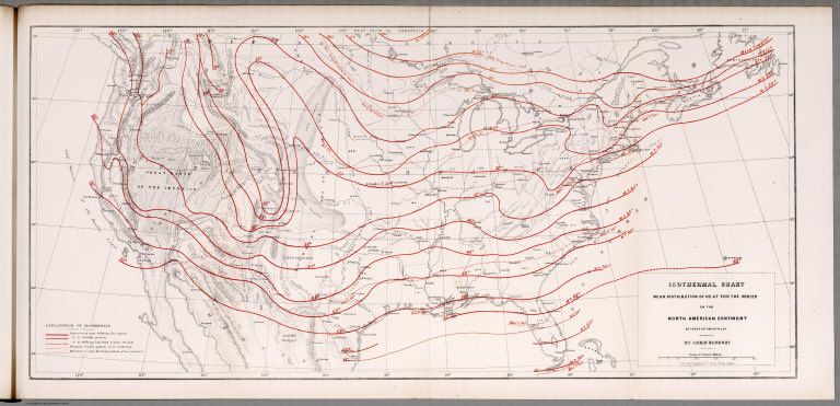
Author
Blodget, Lorin
Full Title
Isothermal chart: Mean distribution of heat for the Winter on the North American Continent; between 25 (degrees) and 50 (degrees) N. Lat. By Lorin Blodget. Fred Bourquin & Co., 50 S. 3rd. St. Phila. (to accompany) Climatology of the United States ...1857.
List No
0083.018
Note
Shows average Winter temperature by isothermal lines. Isothermal lines shown in red. Includes: "Explanation of isothermals". Shows principle cities, rivers, mountains, etc. Relief shown by hachures.
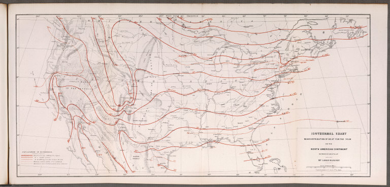
Author
Blodget, Lorin
Full Title
Isothermal chart: Mean distribution of heat for the year on the North American Continent; between 25 (degrees) and 50 (degrees) N. Lat. By Lorin Blodget. Fred Bourquin & Co., 50 S. 3rd. St. Phila. (to accompany) Climatology of the United States ...1857.
List No
0083.019
Note
Shows average annual temperature by isothermal lines.Isothermal lines shown in red. Includes: "Explanation of isothermals". Shows principle cities, rivers, mountains, etc. Relief shown by hachures.
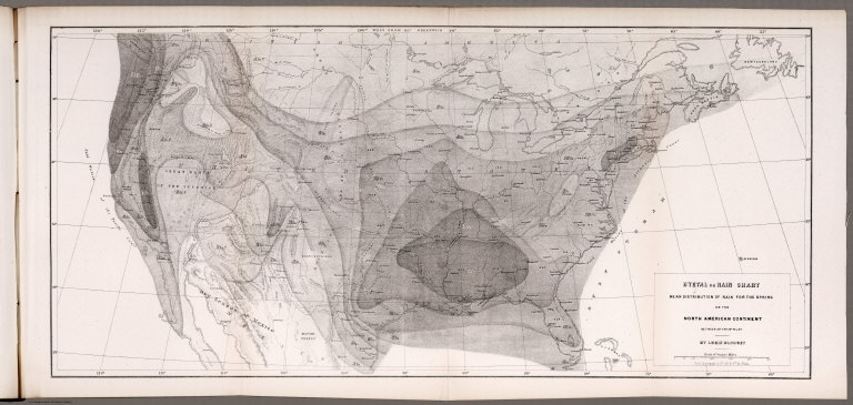
Author
Blodget, Lorin
Full Title
Hyetal or rain chart: Mean distribution of rain for the Spring on the North American Continent; between 25 (degrees) and 50 (degrees) N. Lat. By Lorin Blodget. Fred Bourquin & Co., 50 S. 3rd. St. Phila. (to accompany) Climatology of the United States ...1857.
List No
0083.020
Note
Uncolored seasonal rain map. Showing general distribution of rainfall in inches in Spring over North America. Shows principle cities, rivers, mountains, etc. Relief shown by hachures.
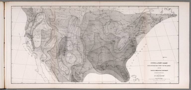
Author
Blodget, Lorin
Full Title
Hyetal or rain chart: Mean distribution of rain for the Summer on the North American Continent; between 25 (degrees) and 50 (degrees) N. Lat. By Lorin Blodget. Fred Bourquin & Co., 50 S. 3rd. St. Phila. (to accompany) Climatology of the United States ...1857.
List No
0083.021
Note
Uncolored seasonal rain map. Showing general distribution of rainfall in inches in summer over North America. Shows principle cities, rivers, mountains, etc. Relief shown by hachures.
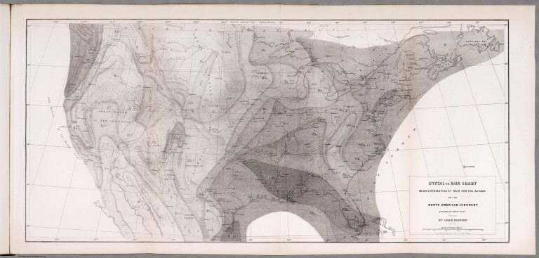
Author
Blodget, Lorin
Full Title
Hyetal or rain chart: Mean distribution of rain for the Autumn on the North American Continent; between 25 (degrees) and 50 (degrees) N. Lat. By Lorin Blodget. Fred Bourquin & Co., 50 S. 3rd. St. Phila. (to accompany) Climatology of the United States ...1857.
List No
0083.022
Note
Uncolored seasonal rain map. Showing general distribution of rainfall in inches in Autumn over North America. Shows principle cities, rivers, mountains, etc. Relief shown by hachures.
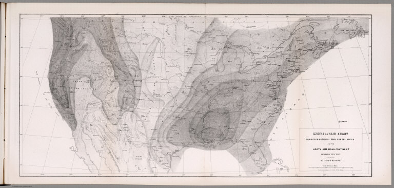
Author
Blodget, Lorin
Full Title
Hyetal or rain chart: Mean distribution of rain for the Winter on the North American Continent; between 25 (degrees) and 50 (degrees) N. Lat. By Lorin Blodget. Fred Bourquin & Co., 50 S. 3rd. St. Phila. (to accompany) Climatology of the United States ...1857.
List No
0083.023
Note
Uncolored seasonal rain map. Showing general distribution of rainfall in inches in Winter over North America. Shows principle cities, rivers, mountains, etc. Relief shown by hachures.
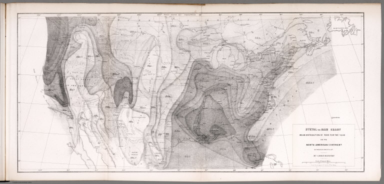
Author
Blodget, Lorin
Full Title
Hyetal or rain chart: Mean distribution of rain for the year on the North American Continent; between 25 (degrees) and 50 (degrees) N. Lat. By Lorin Blodget. Fred Bourquin & Co., 50 S. 3rd. St. Phila. (to accompany) Climatology of the United States ...1857.
List No
0083.024
Note
Uncolored seasonal rain map. Showing general distribution of rainfall in inches in year over North America. Shows principle cities, rivers, mountains, etc. Relief shown by hachures.
Author
Mitchell, Samuel Augustus
Full Title
A New Map of the United States of America. By J.H. Young. Philadelphia. Published by Charles Desilver, No. 251 Market Street. 1857. Entered ... 1856 by Charles Desilver ... Pennsylvania. (with two inset maps) Gold Region of California, and District of Columbia.
List No
2514.009
Note
Full color map. With note on railroad routes proposed to the Pacific Ocean. Shows roads, railroads, battle fields, capitals, important towns, etc. Relief shown by hachures and spot heights. Prime meridians are Washington and Greenwich.
Author
[Johnston, Alexander Keith, 1804-1871, Rogers, Henry Darwin]
Full Title
General Map Of The United States Showing the area and extent of the Free & Slave-Holding States, and the Territories of the Union. Entered in Sta. Hall. London ... & according to an act of Congress ... 1857, by H.D. Rogers ... Massachusetts. London, John Murray, Albemarle Street, Edinburgh, W. & A.K. Johnston. Engraved by W. & A.K. Johnston, Edinburgh.
List No
3825.003
Note
In four colors with dark green (free settled States), light green (territories), dark red (slave importing States, and light red (slave exporting States).
Author
Monk, Jacob
Full Title
(Covers to) Monk's new map of Central America, Yucatan & Florida including Cuba, Jamaica and the Bahama Islands, exhibiting those portions of Alabama, Mississippi, Louisiana, Texas & Mexico bordering on the Gulf of Mexico. Compiled from the latest government maps and orther (sic) authentic sources. 1857. Baltimore, drawn, engraved and printed by A. Hoen & Co. and published by Jacob Monk. Entered ... 1856 by Jacob Monk ... Maryland. (with) Map of the World on Mercator's projection, exhibiting the continent of America in central position...
List No
3936A
Note
This large and decorative map by Monk reflects the interest in Central America in the mid 50's (see Palmer, Wyld, Disturnell, and others) but adds the U.S. coast line from Florida to Texas, which is missing in most of the other maps of Central America. With a large inset map of the World, statistics on the Yucatan, boundary notes on Costa Rica, Historical Notes on Belize and the Mosquito Coast, and the usual abundance of Monk's decorative sailing ships. The inside cover lists this map, Monk's New American Map, and Monk's Railroad and Telegraph Map - which we have never heard of before (although Karrow does list an 1856 edition: 1-1612). Full color map, folded into stamped brown cloth covers 16x11 titled "Monk's New Map Of Central America, Cuba, Florida &c." Relief shown by hachures.
Author
Monk, Jacob
Full Title
Monk's new map of Central America, Yucatan & Florida including Cuba, Jamaica and the Bahama Islands, exhibiting those portions of Alabama, Mississippi, Louisiana, Texas & Mexico bordering on the Gulf of Mexico. Compiled from the latest government maps and orther (sic) authentic sources. 1857. Baltimore, drawn, engraved and printed by A. Hoen & Co. and published by Jacob Monk. Entered ... 1856 by Jacob Monk ... Maryland. (with) Map of the World on Mercator's projection, exhibiting the continent of America in central position...
List No
3936.001
Note
This large and decorative map by Monk reflects the interest in Central America in the mid 50's (see Palmer, Wyld, Disturnell, and others) but adds the U.S. coast line from Florida to Texas, which is missing in most of the other maps of Central America. With a large inset map of the World, statistics on the Yucatan, boundary notes on Costa Rica, Historical Notes on Belize and the Mosquito Coast, and the usual abundance of Monk's decorative sailing ships. The inside cover lists this map, Monk's New American Map, and Monk's Railroad and Telegraph Map - which we have never heard of before (although Karrow does list an 1856 edition: 1-1612). Full color map, folded into stamped brown cloth covers 16x11 titled "Monk's New Map Of Central America, Cuba, Florida &c." Relief shown by hachures.
Author
[Johnston, Alexander Keith, 1804-1871, Rogers, Henry Darwin]
Full Title
(Covers to) Map Of The United States, British & Central America. From State Documents and Unpublished Materials By Professor H.D. Rogers of Boston U.S. and A. Keith Johnston, F.R.S.E. Geographer To The Queen.
List No
4390A
Author
[Johnston, Alexander Keith, 1804-1871, Rogers, Henry Darwin]
Full Title
Map Of The United States, British & Central America. From State Documents and Unpublished Materials By Professor H.D. Rogers of Boston U.S. and A. Keith Johnston, F.R.S.E. Geographer To The Queen.
List No
4390.001
Note
First edition. Very large map of North America with nine inset maps of important cities. This map contains and is the basis of all the maps that appear in the Rogers and Johnston Atlas of the United States of North America, published in the same year. It is a stunning map, very detailed in the west; Wheat did not see this map, but did comment on two of the western maps in the Atlas - "This map is...notable for its clarity, though it is equally notable for the amount of information it contains. W and A.K. Johnston, of Edinburgh, were engravers who well understood their art, and their maps are outstanding." The Proposed Pacific Railway routes are shown. This map compares favorably to the large Colton and Mitchell U.S. maps of the same date (which are also on the same scale) and generally it is more accurate. Scarce, with only the later 1861 edition (title slightly changed - "Map of the United States and Mexico, with Canada...") in Karrow. This first edition is not in any references. A later edition, 1859, was issued with geological coloring (HR 13-123). The map case has Stanford's name at the bottom of the spine, indicating that he sold the map (and perhaps printed it as he did the Atlas). See also the 1861 U.S. only edition (#5405) and the full 1869 edition (#5402).
Author
[Desilver, Charles, Young, James H.]
Full Title
(Covers to) A New Map Of The United States of America By J.H. Young. Philadelphia Published By Charles DeSilver 251 Market St. 1857. Entered ... 1856 by Charles Desilver ... Pennsylvania. Engraved by J.L Hazzard & E. Yeager. (inset) Gold Region Of California. (inset) District Of Columbia.
List No
4400.001
Note
A pocket map edition of the Desilver/Mitchell Universal Atlas map of the same title. Printed on thin paper with larger borders than the atlas version. With advertisements on the inside front cover for Frank and Charles DeSilver's "Splendid Brown Stone Store" which offers (among a long list of exotics) "Havana Segars, Pepper, Cassia, Pimento, Mace, Nutmegs, Cloves, Madder, Indigo, and A Variety of Other Groceries." No mention of maps. Full color, folded into dark green patterned cloth covers 14x9 with "United States Chas. DeSilver Philada." in gilt.
Author
[Desilver, Charles, Young, James H.]
Full Title
A New Map Of The United States of America By J.H. Young. Philadelphia Published By Charles DeSilver 251 Market St. 1857. Entered ... 1856 by Charles Desilver ... Pennsylvania. Engraved by J.L Hazzard & E. Yeager. (inset) Gold Region Of California. (inset) District Of Columbia.
List No
4400.002
Note
A pocket map edition of the Desilver/Mitchell Universal Atlas map of the same title. Printed on thin paper with larger borders than the atlas version. With advertisements on the inside front cover for Frank and Charles DeSilver's "Splendid Brown Stone Store" which offers (among a long list of exotics) "Havana Segars, Pepper, Cassia, Pimento, Mace, Nutmegs, Cloves, Madder, Indigo, and A Variety of Other Groceries." No mention of maps. Full color, folded into dark green patterned cloth covers 14x9 with "United States Chas. DeSilver Philada." in gilt. Prime meridians are Washinton D.C. and Greenwich.
Author
Galveston, Houston, & Henderson Railroad
Full Title
United States of America.
List No
5179.002
Note
Partial color with Texas in pink.
Author
Colton, G.W.
Full Title
(Half Title Page to) Colton's Advertising Atlas Of America. Colton's Atlas Of America. Illustrating The Physical And Political Geography Of North And South America And The West India Islands, By George W. Colton. Accompanied By Descriptions Geographical, Statistical, And Historical, By Richard Swainson Fisher, M.D. New York: J.H. Colton And Company, No. 172 William, Corner Beekman Street. 1857. Entered ... One Thousand Eight Hundred and Fifty-five, by J.H. Colton And Company ... New York.
List No
5479B
Note
Text is "Colton's American Atlas, Published by J.H. Colton & Co. No. 172 William St. New York. C. Wise, Sc.". Illustration of Native American Indians overlooking a valley showing numerous indications of "civilization".
Author
Colton, G.W.
Full Title
(Verso Half Title Page to) Colton's Advertising Atlas Of America. Colton's Atlas Of America. Illustrating The Physical And Political Geography Of North And South America And The West India Islands, By George W. Colton. Accompanied By Descriptions Geographical, Statistical, And Historical, By Richard Swainson Fisher, M.D. New York: J.H. Colton And Company, No. 172 William, Corner Beekman Street. 1857. Entered ... One Thousand Eight Hundred and Fifty-five, by J.H. Colton And Company ... New York.
List No
5479C
Note
Partially intact pasted-in notice to "Gents" from the publisher.
Author
Colton, G.W.
Full Title
(Title Page to) Colton's Atlas Of America. Illustrating The Physical And Political Geography Of North And South America And The West India Islands, By George W. Colton. Accompanied By Descriptions Geographical, Statistical, And Historical, By Richard Swainson Fisher, M.D. New York: J.H. Colton And Company, No. 172 William, Corner Beekman Street. 1857. Entered ... One Thousand Eight Hundred and Fifty-five, by J.H. Colton And Company ... New York.
List No
5479D
Author
Colton, G.W.
Full Title
(Verso Title Page to) Colton's Atlas Of America. Illustrating The Physical And Political Geography Of North And South America And The West India Islands, By George W. Colton. Accompanied By Descriptions Geographical, Statistical, And Historical, By Richard Swainson Fisher, M.D. New York: J.H. Colton And Company, No. 172 William, Corner Beekman Street. 1857. Entered ... One Thousand Eight Hundred and Fifty-five, by J.H. Colton And Company ... New York.
List No
5479E
Note
Index to Advertisers listing name and business alphabetically and keyed to page.
Author
Colton, G.W.
Full Title
(Table of Contents to) Colton's Atlas Of America. Illustrating The Physical And Political Geography Of North And South America And The West India Islands, By George W. Colton. Accompanied By Descriptions Geographical, Statistical, And Historical, By Richard Swainson Fisher, M.D. New York: J.H. Colton And Company, No. 172 William, Corner Beekman Street. 1857. Entered ... One Thousand Eight Hundred and Fifty-five, by J.H. Colton And Company ... New York.
List No
5479F
Note
Text reads: "List of Maps contained in Colton's Atlas of the World, Volume 1." Lists 63 sheets for places in North and South America.
Author
Colton, G.W.
Full Title
North America. No. 2. Published by J.H. Colton & Co., No 172 William St., New York. Entered according to the Act of Congress in the year 1855 by J.H. Colton & Co. in the Clerk's Office of the District Court of the United States for the Southern District of New York.
List No
5479.004
Note
Meridians Washington and Greenwich. States tinted in color. Relief shown in hachures.
Author
Colton, G.W.
Full Title
The United States of America. No. (7-) 8. Published by J.H. Colton & Co., No 172 William St., New York. Entered according to the Act of Congress in the year 1855 by J.H. Colton & Co. in the Clerk's Office of the District Court of the United States for the Southern District of New York.
List No
5479.014
Note
Meridians Washington and Greenwich. States tinted in color.
Author
Colton, G.W.
Full Title
Maine. No. 9. Published by J.H. Colton & Co., No 172 William St., New York. Entered according to the Act of Congress in the year 1855 by J.H. Colton & Co. in the Clerk's Office of the District Court of the United States for the Southern District of New York.
List No
5479.026
Note
Meridians Washington and Greenwich. Counties tinted in color.
Author
Colton, G.W.
Full Title
New Hampshire. No. 10. Published by J.H. Colton & Co., No 172 William St., New York. Entered according to the Act of Congress in the year 1855 by J.H. Colton & Co. in the Clerk's Office of the District Court of the United States for the Southern District of New York.
List No
5479.028
Note
Meridians Washington and Greenwich. Counties tinted in color.
Author
Colton, G.W.
Full Title
Vermont. No. 11. Published by J.H. Colton & Co., No 172 William St., New York. Entered according to the Act of Congress in the year 1855 by J.H. Colton & Co. in the Clerk's Office of the District Court of the United States for the Southern District of New York.
List No
5479.030
Note
Meridians Washington and Greenwich. Counties tinted in color.
Author
Colton, G.W.
Full Title
Massachusetts and Rhode Island. No. 12. Published by J.H. Colton & Co., No 172 William St., New York. Entered according to the Act of Congress in the year 1855 by J.H. Colton & Co. in the Clerk's Office of the District Court of the United States for the Southern District of New York.
List No
5479.032
Note
Meridians Washington and Greenwich. Counties tinted in color.
Author
Colton, G.W.
Full Title
Map of Boston and Adjacent Cities. No. 13. Published by J.H. Colton & Co., No 172 William St., New York. Entered according to the Act of Congress in the year 1855 by J.H. Colton & Co. in the Clerk's Office of the District Court of the United States for the Southern District of New York.
List No
5479.034
Note
Meridians Washington and Greenwich. Districts tinted in color.
Author
Colton, G.W.
Full Title
Connecticut with Portions of New York and Rhode Island. No. 14. Published by J.H. Colton & Co., No 172 William St., New York. Entered according to the Act of Congress in the year 1855 by J.H. Colton & Co. in the Clerk's Office of the District Court of the United States for the Southern District of New York.
List No
5479.036
Note
Meridians Washington and Greenwich. Counties tinted in color.
Author
Colton, G.W.
Full Title
New York. No. 15. Published by J.H. Colton & Co., No 172 William St., New York. Entered according to the Act of Congress in the year 1855 by J.H. Colton & Co. in the Clerk's Office of the District Court of the United States for the Southern District of New York.
List No
5479.038
Note
Meridians Washington and Greenwich. Counties tinted in color. Insets of the Vicinity of Niagara Falls and the Vicinity of New York (City).
Author
Colton, G.W.
Full Title
Map of New York (City) and the Adjacent Cities. No. 18. Published by J.H. Colton & Co., No 172 William St., New York. Entered according to the Act of Congress in the year 1855 by J.H. Colton & Co. in the Clerk's Office of the District Court of the United States for the Southern District of New York.
List No
5479.041
Note
Meridians Washington and Greenwich. Foold-out map. Neighborhoods tinted in color. Inset of the Continuation of the City and County of New York (upper Manhattan) on a Reduced Scale. Street map. Shows hospital, penitentiary, alms houses (for females and males), work house, new mad hoouse, old mad house, and lunatic asylum, all on Blackwells Island.
Author
Colton, G.W.
Full Title
New Jersey. No. 19. Published by J.H. Colton & Co., No 172 William St., New York. Entered according to the Act of Congress in the year 1855 by J.H. Colton & Co. in the Clerk's Office of the District Court of the United States for the Southern District of New York.
List No
5479.042
Note
Meridian Washington (D.C.). Counties tinted in color.
Author
Colton, G.W.
Full Title
Pennsylvania. No. 20. Published by J.H. Colton & Co., No 172 William St., New York. Entered according to the Act of Congress in the year 1855 by J.H. Colton & Co. in the Clerk's Office of the District Court of the United States for the Southern District of New York.
List No
5479.044
Note
Meridians Washington and Greenwich. Counties tinted in color.
Author
Colton, G.W.
Full Title
Philadelphia. No. 21. Published by J.H. Colton & Co., No 172 William St., New York. Entered according to the Act of Congress in the year 1855 by J.H. Colton & Co. in the Clerk's Office of the District Court of the United States for the Southern District of New York.
List No
5479.046
Note
Meridians Washington and Greenwich. Neighborhoods tinted in color.
Author
Colton, G.W.
Full Title
Delaware and Maryland. No. 22. Published by J.H. Colton & Co., No 172 William St., New York. Entered according to the Act of Congress in the year 1855 by J.H. Colton & Co. in the Clerk's Office of the District Court of the United States for the Southern District of New York.
List No
5479.048
Note
Meridians Washington and Greenwich. Neighborhoods tinted in color. Inset of District of Columbia (Washington D.C.)
Author
Colton, G.W.
Full Title
City of Baltimore, Maryland. No. 23. Published by J.H. Colton & Co., No 172 William St., New York. Entered according to the Act of Congress in the year 1855 by J.H. Colton & Co. in the Clerk's Office of the District Court of the United States for the Southern District of New York.
List No
5479.051
Note
Meridians Washington and Greenwich. Neighborhoods tinted in color. Street map.
Author
Colton, G.W.
Full Title
Georgetown and the City of Washington, the Capital of the United States of America. No. 24. Published by J.H. Colton & Co., No 172 William St., New York. Entered according to the Act of Congress in the year 1855 by J.H. Colton & Co. in the Clerk's Office of the District Court of the United States for the Southern District of New York.
List No
5479.053
Note
Neighborhoods tinted in color. Street map. Vignettes of Washington Monument, Smithsonian Institution, and the Capitol.
Author
Colton, G.W.
Full Title
Virginia. No. 25. Published by J.H. Colton & Co., No 172 William St., New York. Entered according to the Act of Congress in the year 1855 by J.H. Colton & Co. in the Clerk's Office of the District Court of the United States for the Southern District of New York.
List No
5479.055
Note
Meridians Washington and Greenwich. Counties tinted in color. Relief shown in hachures. Insets for Richmond, Manchester and Springhill, and for Norfolk, Portsmouth, and Gosport.
Author
Colton, G.W.
Full Title
North Carolina. No. 26. Published by J.H. Colton & Co., No 172 William St., New York. Entered according to the Act of Congress in the year 1855 by J.H. Colton & Co. in the Clerk's Office of the District Court of the United States for the Southern District of New York.
List No
5479.057
Note
Counties tinted in color. Meridians Washington and Greenwich. Inset of Beaufort Harbor.
Author
Colton, G.W.
Full Title
South Carolina. No. 27. Published by J.H. Colton & Co., No 172 William St., New York. Entered according to the Act of Congress in the year 1855 by J.H. Colton & Co. in the Clerk's Office of the District Court of the United States for the Southern District of New York.
List No
5479.059
Note
Meridians Washington and Greenwich. Counties tinted in color. Relief shown in hachures. Inset for Plan of Charleston, Vicinity & Harbor.
Author
Colton, G.W.
Full Title
The City of Savannah, Georgia. The City of Charleston, South Carolina. No. 28. Published by J.H. Colton & Co., No 172 William St., New York. Entered according to the Act of Congress in the year 1855 by J.H. Colton & Co. in the Clerk's Office of the District Court of the United States for the Southern District of New York.
List No
5479.061
Note
Two maps on one sheet. Neighborhoods tinted in color. Swampland shown. Street map with key to significant places.
Author
Colton, G.W.
Full Title
Georgia. No. 29. Published by J.H. Colton & Co., No 172 William St., New York. Entered according to the Act of Congress in the year 1855 by J.H. Colton & Co. in the Clerk's Office of the District Court of the United States for the Southern District of New York.
List No
5479.063
Note
Meridians Wasington and Greenwich. Counties tinted in color. Relief shown in hachures.
|