|
REFINE
Browse All : Images of United States and Wyoming
1-43 of 43
Author
U.S. General Land Office
Full Title
(Map 11 - Wyoming, Nebraska, Colorado, Kansas, South Dakota).
List No
1071.013
Note
One of the series of adjacent sixteen maps. Mounted on linen. Relief shown in hachures.
Author
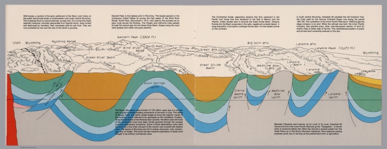
Raymo, Chet
Full Title
(Utah, Wayoming). (to accompany) A geologic and topographic profile of the United States along interstate 80 : by Chet Raymo. 1982. Printed by Hubbard, Northbrook, IL.
List No
13323.008
Note
Geologic cross section and map of Utah to Wyoming. Covers the area southwestern and south central Wyoming, showing the earth's crust, drainage and mountains. Relief shown pictorially and spot heights. "In the south central Wyoming, Interstate 80 parallels the Overland Trail". Includes descriptive text.
Author
Rand McNally and Company
Full Title
(Text Page) Indian Territory. (Oklahoma). Wyoming.
List No
2094DG
Note
List of geographical features indexed to map.
Author
Rand McNally and Company
Full Title
Rand, McNally & Co.'s Wyoming.
List No
2094.055
Note
Counties outlined in color. Railroads highlighted. Relief shown by hachures.
Author
Rand McNally and Company
Full Title
(Text Page) Rand, McNally Co.'s Wyoming.
List No
2844DQ
Note
Tables of railroads and geographical features keyed to map.
Author
Rand McNally and Company
Full Title
Rand, McNally & Co.'s Wyoming.
List No
2844.072
Note
Tables of railroads and chief cities keyed to map.
Author
Rand McNally and Company
Full Title
(Text Page) Rand, McNally Co.'s Wyoming. Rand, McNally Co.'s Utah.
List No
2844DR
Note
Tables of railroads and geographical features keyed to map.
Author
[Warner, Higgins & Beers, Lloyd, H.H.]
Full Title
Atlas of the United States. Map of the territory of Montana, Idaho and Wyoming. Warner, Higgins & Beers Publishers. From H. H. Lloyd & Co.,s. Atlas of the United States. (to accompany) Atlas of the State of Illinois To Which Is Added An Atlas Of The United States Maps of The Hemispheres &c. &c. &c. Warner, Higgins & Beers Publishers. 143 Clark St. Chicago. 1871.
List No
3749.041
Note
Outline hand colored lithographed map. Showing state and county boundaries, cities, towns, rivers, roads and railroads. Relief shown by hachures. Prime meridians are Washington, D.C. and Greenwich.
Author
National Map Company
Full Title
Wyoming. (Copyrighted by) National Map Company, Indianapolis. (to accompany) Official Paved Road and Commercial Survey of the United States.
List No
4048.047
Note
Outline color map. Shows administrative divisions, roads, rivers, etc. Relief shown by hachures. Prime meridian is Greenwich.
Author
[Chicago, Burlington & Quincy Railroad Company, Northern Pacific Railroad Company]
Full Title
(Text Page to) Burlington Route - Northern Pacific Railway. Yellowstone National Park. Copyrighted, 1898, by Poole Bros., Chicago ... (1901)
List No
4088B
Note
Includes text, illustrations, distance chart, statistical table, list of agents, and map: Map of Burlington Route and connecting lines "4-1-'01"
Author
Hague, Arnold
Full Title
(Covers to) Department Of The Interior, United States Geological Survey, Charles D. Walcott, Director. Atlas To Accompany Monograph XXXII On The Geology Of The Yellowstone National Park, By Arnold Hague. Washington, 1904. Julius Bien & Co. Lith. N.Y.
List No
4252A
Note
Bound in original dark brown cloth covered boards with "United States Geological Survey, Charles D. Walcott, Director. Atlas To Accompany Monograph XXXII On The Geology Of The Yellowstone National Park. Arnold Hague" stamped in gilt.
Author
Hague, Arnold
Full Title
(Title Page to) Department Of The Interior, United States Geological Survey, Charles D. Walcott, Director. Atlas To Accompany Monograph XXXII On The Geology Of The Yellowstone National Park, By Arnold Hague. Washington, 1904. Julius Bien & Co. Lith. N.Y.
List No
4252B
Author
Hague, Arnold
Full Title
(Table of Contents to) Department Of The Interior, United States Geological Survey, Charles D. Walcott, Director. Atlas To Accompany Monograph XXXII On The Geology Of The Yellowstone National Park, By Arnold Hague. Washington, 1904. Julius Bien & Co. Lith. N.Y.
List No
4252C
Author
Hague, Arnold
Full Title
(Legend to) Department Of The Interior, United States Geological Survey, Charles D. Walcott, Director. Atlas To Accompany Monograph XXXII On The Geology Of The Yellowstone National Park, By Arnold Hague. Washington, 1904. Julius Bien & Co. Lith. N.Y.
List No
4252D
Note
This page is a detailed description of the atlas and some of the geologic processes in Yellowstone National Park.
Author
Hague, Arnold
Full Title
Gallatin Sheet. Topography Sheet IV. Monograph XXXII. Yellowstone National Park. U.S. Geological Survey. Charles D. Walcott, Director. 1904. Julius Bien & Co. Lith. N.Y. Henry Gannett, Chief Geographer. J.H. Renshawe, Geographer in charge. Triangulation by H.S. Chase. Topography by J.H. Renshawe, Frank Tweedy, H.S. Chase, and S.A. Alpin Jr. Surveyed in 1883-5.
List No
4252.001
Note
Topography shown in 100-foot contours.
Author
Hague, Arnold
Full Title
Shoshone Sheet. Topography Sheet V. Monograph XXXII. Yellowstone National Park. U.S. Geological Survey. Charles D. Walcott, Director. 1904. Julius Bien & Co. Lith. N.Y. Henry Gannett, Chief Geographer. J.H. Renshawe, Geographer in charge. Triangulation by H.S. Chase. Topography by W.H. Leffingwell, Frank Tweedy, J.H. Renshawe, and S.A. Alpin Jr. Surveyed in 1884-5.
List No
4252.002
Note
Topography shown in 100-foot contours.
Author
Hague, Arnold
Full Title
Canyon Sheet. Topography Sheet VI. Monograph XXXII. Yellowstone National Park. U.S. Geological Survey. Charles D. Walcott, Director. 1904. Julius Bien & Co. Lith. N.Y. Henry Gannett, Chief Geographer. J.H. Renshawe, Geographer in charge. Triangulation by H.S. Chase. Topography by Frank Tweedy. Surveyed in 1884-5.
List No
4252.003
Note
Topography shown in 100-foot contours.
Author
Hague, Arnold
Full Title
Lake Sheet. Topography Sheet VII. Monograph XXXII. Yellowstone National Park. U.S. Geological Survey. Charles D. Walcott, Director. 1904. Julius Bien & Co. Lith. N.Y. Henry Gannett, Chief Geographer. J.H. Renshawe, Geographer in charge. Triangulation by H.S. Chase. Topography by J.H. Renshawe. Surveyed in 1885.
List No
4252.004
Note
Topography shown in 100-foot contours.
Author
Hague, Arnold
Full Title
Crandall Sheet. Topography Sheet VIII. Monograph XXXII. Yellowstone National Park. U.S. Geological Survey. Charles D. Walcott, Director. 1904. Julius Bien & Co. Lith. N.Y. A. H. Thompson, Geographer. Triangulation and Topography by Frank Tweedy. Surveyed in 1893.
List No
4252.005
Note
Topography shown in 100-foot contours.
Author
Hague, Arnold
Full Title
Ishawooa Sheet. Topography Sheet IX. Monograph XXXII. Yellowstone National Park. U.S. Geological Survey. Charles D. Walcott, Director. 1904. Julius Bien & Co. Lith. N.Y. A. H. Thompson, Geographer. Triangulation and Topography by Frank Tweedy. Surveyed in 1893.
List No
4252.006
Note
Topography shown in 100-foot contours.
Author
Hague, Arnold
Full Title
Gallatin Sheet. Geology Sheet X. Monograph XXXII. Yellowstone National Park. U.S. Geological Survey. Charles D. Walcott, Director. 1904. Julius Bien & Co. Lith. N.Y. Henry Gannett, Chief Geographer. J.H. Renshawe, Geographer in charge. Triangulation by H.S. Chase. Topography by J.H. Renshawe, Frank Tweedy, H.S. Chase, and S.A. Alpin Jr. Surveyed in 1883-5. Geology by Arnold Hague, Geologist in charge, Joseph Paxson Iddings, Walter Harvey Weed, and George M. Wright, Surveyed 1883 to 91, and 93.
List No
4252.007
Note
Topography shown in 100-foot contours, overlaid in color with 26 classes of rock types, and faults. Legend.
Author
Hague, Arnold
Full Title
Shoshone Sheet. Geology Sheet XI. Monograph XXXII. Yellowstone National Park. U.S. Geological Survey. Charles D. Walcott, Director. 1904. Julius Bien & Co. Lith. N.Y. Henry Gannett, Chief Geographer. J.H. Renshawe, Geographer in charge. Triangulation by H.S. Chase. Topography by W.H. Leffingwell, Frank Tweedy, J.H. Renshawe, and S.A. Alpin Jr. Surveyed in 1884-5. Geology by Arnold Hague, Geologist in charge, Joseph Paxson Iddings, and Walter Harvey Weed, Surveyed 1883 to 91, and 1893.
List No
4252.008
Note
Topography shown in 100-foot contours, overlaid in color with 22 classes of rock types, and faults. Legend.
Author
Hague, Arnold
Full Title
Canyon Sheet. Geology Sheet XII. Monograph XXXII. Yellowstone National Park. U.S. Geological Survey. Charles D. Walcott, Director. 1904. Julius Bien & Co. Lith. N.Y. Henry Gannett, Chief Geographer. J.H. Renshawe, Geographer in charge. Triangulation by H.S. Chase. Topography by Frank Tweedy. Surveyed in 1884-5. Geology by Arnold Hague, Geologist in charge, Joseph Paxson Iddings, Walter Harvey Weed, and George M. Wright, Surveyed 1883 to 91, and 93.
List No
4252.009
Note
Topography shown in 100-foot contours, overlaid in color with 22 classes of rock types, and faults. Legend.
Author
Hague, Arnold
Full Title
Lake Sheet. Geology Sheet VII. Monograph XXXII. Yellowstone National Park. U.S. Geological Survey. Charles D. Walcott, Director. 1904. Julius Bien & Co. Lith. N.Y. Henry Gannett, Chief Geographer. J.H. Renshawe, Geographer in charge. Triangulation by H.S. Chase. Topography by J.H. Renshawe. Surveyed in 1885. Geology by Arnold Hague, Geologist in charge, Joseph Paxson Iddings, and Walter Harvey Weed, Surveyed 1883 to 89, and 93.
List No
4252.010
Note
Topography shown in 100-foot contours, overlaid in color with 22 classes of rock types, and faults. Legend.
Author
Hague, Arnold
Full Title
Crandall Sheet. Geology Sheet VIII. Monograph XXXII. Yellowstone National Park. U.S. Geological Survey. Charles D. Walcott, Director. 1904. Julius Bien & Co. Lith. N.Y. A. H. Thompson, Geographer. Triangulation and Topography by Frank Tweedy. Surveyed in 1893. Geology by Arnold Hague, Geologist in charge, Assisted by Joseph P. Iddings and Thomas A. Jaggar Jr., Surveyed in 1893 and 1897.
List No
4252.011
Note
Topography shown in 100-foot contours, overlaid in color with 15 classes of rock types, and dikes and faults. Legend.
Author
Hague, Arnold
Full Title
Ishawooa Sheet. Geology Sheet XV. Monograph XXXII. Yellowstone National Park. U.S. Geological Survey. Charles D. Walcott, Director. 1904. Julius Bien & Co. Lith. N.Y. A. H. Thompson, Geographer. Triangulation and Topography by Frank Tweedy. Surveyed in 1893. Geology by Arnold Hague, Geologist in charge, Assisted by Thomas A. Jaggar Jr., Surveyed in 1893 and 1897.
List No
4252.012
Note
Topography shown in 100-foot contours, overlaid in color with 11 classes of rock types, and dikes and faults. Legend.
Author
Hague, Arnold
Full Title
Yellowstone National Park and Portion of Yellowstone Forest Reserve. Topography Sheet XVI. Monograph XXXII. Yellowstone National Park. U.S. Geological Survey. Charles D. Walcott, Director. 1904. Julius Bien & Co. Lith. N.Y. Reduced from U.S. Geological Survey Atlas sheets.
List No
4252.013
Note
Topography shown in 100-foot contours. Roads and trails shown.
Author
Hague, Arnold
Full Title
Yellowstone National Park and Portion of Yellowstone Forest Reserve. Geology Sheet XVII. Monograph XXXII. Yellowstone National Park. U.S. Geological Survey. Charles D. Walcott, Director. 1904. Julius Bien & Co. Lith. N.Y. Geology by Arnold Hague, Geologist in charge, Assisted by Joseph P. Iddings, Walter Harvey Weed, George M. Wright, and Thomas A. Jaggar Jr.
List No
4252.014
Note
Topography shown in 100-foot contours, overlaid in vibrant color with 34 classes of rock types, and dikes and faults. Legend.
Author
Hague, Arnold
Full Title
Mammoth Hot Springs and Vicinity. Topography Sheet XVIII. Monograph XXXII. Yellowstone National Park. U.S. Geological Survey. Charles D. Walcott, Director. 1904. Julius Bien & Co. Lith. N.Y. Topography by Anton Karl, assisted by Joseph R. Bien.
List No
4252.015
Note
Topography shown in 20-foot contours. Structures, roads and trails shown.
Author
Hague, Arnold
Full Title
Mammoth Hot Springs and Vicinity. Geology Sheet XIX. Monograph XXXII. Yellowstone National Park. U.S. Geological Survey. Charles D. Walcott, Director. 1904. Julius Bien & Co. Lith. N.Y. Topography by Anton Karl, assisted by Joseph R. Bien. Geology by Arnold Hague, Geologist in charge and Walter Harvey Weed.
List No
4252.016
Note
Topography shown in 20-foot contours, overlaid in color with 12 classes of rock types. Legend.
Author
Hague, Arnold
Full Title
Detail Map of Mammoth Hot Springs Travertine Terraces. Topography Sheet XX. Monograph XXXII. Yellowstone National Park. U.S. Geological Survey. Charles D. Walcott, Director. 1904. Julius Bien & Co. Lith. N.Y. Topography by Anton Karl, assisted by Joseph R. Bien. Mapped in 1887. Partially revised 1899 by R.H. Chapman.
List No
4252.017
Note
Topography shown in 5-foot contours. Structures and roads shown.
Author
Hague, Arnold
Full Title
Norris Geyser Basin. Geology Sheet XXI. Monograph XXXII. Yellowstone National Park. U.S. Geological Survey. Charles D. Walcott, Director. 1904. Julius Bien & Co. Lith. N.Y. Topography by Anton Karl, assisted by Joseph R. Bien. Geology by Arnold Hague and Walter Harvey Weed.
List No
4252.018
Note
Topography shown in 10-foot contours, overlaid in color with 6 classes of rock types. Legend.
Author
Hague, Arnold
Full Title
Firehole Geyser Basin. Geology Sheet XXII. Monograph XXXII. Yellowstone National Park. U.S. Geological Survey. Charles D. Walcott, Director. 1904. Julius Bien & Co. Lith. N.Y. Topography by Anton Karl, assisted by Joseph R. Bien. Geology by Arnold Hague, Geologist in charge, and Walter Harvey Weed.
List No
4252.019
Note
Topography shown in 10-foot contours, overlaid in color with 6 classes of rock types. Legend.
Author
Hague, Arnold
Full Title
Excelsior Geyser Basin. Geology Sheet XXIII. Monograph XXXII. Yellowstone National Park. U.S. Geological Survey. Charles D. Walcott, Director. 1904. Julius Bien & Co. Lith. N.Y. Topography by Anton Karl, assisted by Joseph R. Bien. Geology by Arnold Hague and Walter Harvey Weed.
List No
4252.020
Note
Topography shown in 5-foot contours, overlaid in color with 4 classes of rock types. Legend.
Author
Hague, Arnold
Full Title
Upper Geyser Basin. Geology Sheet XXIV. Monograph XXXII. Yellowstone National Park. U.S. Geological Survey. Charles D. Walcott, Director. 1904. Julius Bien & Co. Lith. N.Y. Topography by Anton Karl, assisted by Joseph R. Bien. Geology by Arnold Hague, Geologist in charge, and Walter Harvey Weed.
List No
4252.021
Note
Topography shown in 20-foot contours, overlaid in color with 5 classes of rock types. Legend.
Author
Hague, Arnold
Full Title
Central Portion of Upper Geyser Basin. Topography Sheet XXV. Monograph XXXII. Yellowstone National Park. U.S. Geological Survey. Charles D. Walcott, Director. 1904. Julius Bien & Co. Lith. N.Y. Topography by Anton Karl, assisted by Joseph R. Bien.
List No
4252.022
Note
Topography shown in 5-foot contours. Shows structures and roads.
Author
Hague, Arnold
Full Title
Shoshone Geyser Basin. Geology Sheet XXVI. Monograph XXXII. Yellowstone National Park. U.S. Geological Survey. Charles D. Walcott, Director. 1904. Julius Bien & Co. Lith. N.Y. Topography by Anton Karl, assisted by Joseph R. Bien. Surveyed by Hayden Survey, 1878, revised and contours added by Walter Harvey Weed. Geology by Walter Harvey Weed.
List No
4252.023
Note
Topography shown in 5-foot contours, overlaid in color with 5 classes of rock types. Legend.
Author
Hague, Arnold
Full Title
The Shores of Yellowstone Lake. Geology Sheet XXVII. Monograph XXXII. Yellowstone National Park. U.S. Geological Survey. Charles D. Walcott, Director. 1904. Julius Bien & Co. Lith. N.Y. A.H. Thompson, Geographer. Topography by Frank E. Grove, Philip Sawyer under charge of Frank Tweedy. Suveryed in 1889. Arnold Hague, Geologist in charge. Geology by Walter Harvey Weed.
List No
4252.024
Note
Topography shown in 20-foot contours, overlaid in color with 7 classes of rock types. Legend. Note provided on the survey history and on the geomorphic history of Yellowstone Lake.
Author
Johnson, Alvin Jewett, 1827-1884.
Full Title
Johnson's Nebraska, Dakota, Idaho, Montana and Wyoming. Published by Alvin J. Johnson & Son, New York. Entered ... 1865, by A.J. Johnson ... New York. (to accompany) Johnson's New Illustrated Family Atlas Of The World ... MDCCCLXXX (1880).
List No
4830.094
Note
Engraved hand colored in outline map on 2 sheets. Shows state and county boundaries, towns, villages, roads, railroads, canals, lakes, mountains and rivers. Relief shown by hachures. Prime meridians are Greenwich and Washington.
Author
Asher & Adams
Full Title
Asher & Adams' Wyoming. Entered according to Act of Congress 1874 by Asher & Adams in the Office of the Librarian of Congress at Washington.
List No
4977.068
Note
Washington Meridian. Hand tinted full color. Shows railroads, settlements, counties, waterways, and lakes. Topography in Yellowstone National Park and southwest corner of Dakota shown by hachures. Engraved.
Author
Rand McNally and Company
Full Title
(Text Page) Industrial Statistics of the United States. Wisconsin. Wyoming. Maine - Counties, Islands, Lakes, Ponds, Rivers, Towns.
List No
5028AK
Note
Industrial statistics by state and county including county seat, area, and statistics on population, agriculture and manufacturing. Includes descriptions of mines, quarries, and wells. Geographical features keyed to map; populations of towns.
Author
Marbut, Curtis F.
Full Title
Soil Map of the United States by Curtis F. Marbut and Associates in the Soil Survery, U.S. Department of Agriculture, F.J. Marschner, Cartographer and Associate in Compilation. 1931. Soils, Plate 5, Section 3. Lith. A. Hoen & Co., Inc. Atlas of American Agriculture.
List No
5797.084
Note
Includes legend of 12 map sections. Includes soils legend for this section and landscape photographs.
Author
[Rand McNally and Company, State Farm Insurance Companies Travel Bureau]
Full Title
Rand McNally Road map: Wyoming. Copyright by Rand McNally & Company, Chicago, Ill. Lithorgaphed in the U.S.A. U.3601. (to accompany) State Farm road atlas : United States, Canada, Mexico.
List No
6825.050
Note
Color map. U.S. interstate highways shown in red. Shows time zone boundaries, roads, ferries, highways, rivers and streams. Includes population of cities and towns. Relief shown by hachures.
1-43 of 43
|