|
Author
Ronin, Mary
Full Title
The United States : The land and the people = Les Etats-Unis : Le pays et ses habitants = De Verenigde Staten : Het land en her volk. Mary Ronin. Printed in Holland.
List No
14464.001
Note
Pictorial map of the United States, featuring the national and ancestral origins of its people. Souvenir map from the United States Pavilion of the Brussels Universal and International Exhibition of 1958. Also shows political boundaries, natural resources, topography, bodies of water, drainage and coastlines. Relief shown with shading. Includes a compass rose with north oriented toward top of sheet, as well as descriptive text. With three inset maps: Alaska -- Hawaii -- Puerto Rico and the Virgin Islands. Title and text appears in parallel English, French and Dutch. Colored lithograph. Map is 47 x 67 cm, on sheet 48 x 69 cm. Verso has a plan for the United States Pavilion.
Author
[United States. Office of War Information, United States. Army. Western Defense Command, United States. Wartime Civil Control Administration]
Full Title
Geographical distribution : Japanese population, United States : 1940. Western Defense Command and Fourth Army, Wartime Civil Control Administration.
List No
14375.026
Note
Map of the United States, featuring the geographical distribution of the Japanese American population in the United States in 1940. Shows political boundaries and the number of Japanese Americans in each state, utilizing data visualization to illustrate population density. Includes explanatory note. In color. Map is 15 x 23 cm. Figure 5-b. Appears in Part IV : Evacuation - its operational technique, Chapter VIII : Development and execution of the evacuation plan. (Page number inferred.)
Author
[United States. Office of War Information, United States. Army. Western Defense Command, United States. Wartime Civil Control Administration]
Full Title
Net voluntary movement of Japanese : Western Defense Command Area, March 12th to June 5th, 1942. Western Defense Command and Fourth Army, Wartime Civil Control Administration.
List No
14375.033
Note
Map of the United States, featuring the allegedly voluntary migration of Japanese Americans in the Western Defense Command Area, from March 12th to June 5th, 1942. Shows political boundaries and utilizes data visualization to illustrate population density within the migration to different places. Includes a legend and explanatory note. Black and white. Map is 11 x 16 cm, on sheet 15 x 23 cm. Figure 11. Appears in Part IV : Evacuation - its operational technique, Chapter IX : Voluntary migration.
Author
United States. Office of War Information
Full Title
War relocation project sites.
List No
14375.076
Note
Map of the United States featuring the war relocation project sites. Shows political boundaries, cities and roads. Includes a legend. In color. Map is 14 x 18 cm, on sheet 15 x 23 cm. Figure 21. With descriptive text on facing page. Appears in Part VI : Relocation of evacuees, Chapter XXI : The construction and equipment of relocation centers.
Author
[Pershing, John J. (John Joseph), 1860-1948, Geological Survey (U.S.)]
Full Title
Map of France superimposed on that of the United States : Showing relative distances and the extent of railroad systems used by the American Expeditionary Forces. House Doc. No. 626; 66th Cong., 2d Sess. Engraved and printed by the U. S. Geological Survey.
List No
14379.023
Note
Military map of France, overlaid upon the United States in order to show the relative distances between different cities. Features the railroad systems used by the American Expeditionary Forces during World War I. Shows political boundaries, cities, drainage, coastlines and islands. Includes a legend, explanatory notes and two bar scales given in kilometers and miles, as well as a compass rose with north oriented toward top of sheet (for the United States). Colored engraving. Map is 20 x 24 cm, on fold-out sheet 23 x 27 cm.
Author
[3, Soviet Union. Glavnoe upravlenie geodezii i kartografii]
Full Title
Соединенные Штаты Америки = Soyedinennye Shtaty Ameriki. 227-228. Atlas Mira : 1954.
List No
13682.241
Note
Physical map of the United States. Relief shown by shadings and spot heights. Depths shown by gradient tints, isolines and soundings.
Author
[3, Soviet Union. Glavnoe upravlenie geodezii i kartografii]
Full Title
Запад США = Zapad SShA. 242-243. Atlas Mira : 1954.
List No
13682.256
Note
Physical map of the West of the United States. Showing state boundaries. Relief shown by shadings, contours and spot heights. Depths shown by gradient tints, isolines and soundings.
Author
Faden, William, 1749-1836
Full Title
The United States of North America, with the British Territories, and those of Spain, according to the Treaty, of 1784. Engrav'd by Wm. Faden. 1793. Published as the Act directs, Feby. 11, 1793, by Willm. Faden, Geographer to the King, Charing Cross.
List No
14383.057
Note
Map of the United States, as of 1793. Shows political boundaries (including colonial possessions), cities, topography, bodies of water, drainage, coastlines, islands and sand banks. Marks territories inhabited by indigenous peoples, such as the "Western Sioux". Relief shown pictorially. Includes latitudinal and longitudinal lines, as well as a legend and two bar scales. Descriptive text throughout, including notes on exploration. Decorative cartouche. Hand-colored engraving. Map is 53 x 61 cm, on double sheet 55 x 75 cm. With stamp: Liverpool Library.
Author
Stanford, Edward
Full Title
Stanford's Handy Map of the United States Distinguishing The Unsettled Territories; The Railways; The Cities & Towns according to Population; also the State Capitals & County Towns. London: Edward Stanford, 55 Charing Cross, S.W., March 1st. 1876.
List No
2348.002
Author
Jefferson, Louise E. (1930-2000)
Full Title
Makers Of The U.S.A.
List No
15246.000
Author
Trans World Airlines
Full Title
(Covers to) TWA air routes in the United States.
List No
14394.001
Note
Covers to TWA air routes in the United States. Unfolds to reveal full imagery, which includes the outline of the continental United States and a grid of views, which features popular tourist sites, such as the cable cars of San Francisco. Colored lithograph. Folds to 26 x 13 cm.
Author
Trans World Airlines
Full Title
How to use your TWA air atlas.
List No
14394.002
Note
Index map to TWA air routes in the United States. Features the geographic locations of the other five maps within the atlas, and the air routes within those geographic areas. Also shows cities, topography, bodies of water, coastlines, islands and time zones. Relief shown with shading and peak heights. Includes a legend and descriptive text. Colored lithograph. Map is 26 x 40 cm, on double sheet 26 x 52 cm.
Author
Trans World Airlines
Full Title
This flight map is yours, keep it as a souvenir of your TWA journey.
List No
14394.009
Note
Final section to TWA air routes in the United States. Provides space for the owner of the atlas to write their flight notes, such as locations of departure, arrival and dates. Includes illustration of an airplane flying above the clouds, as well as an outline of the United States.
Author
The Black Panther Party
Full Title
(Title page to) The Black Panther. Guerrilla War in the U.S.A.
List No
15227.001
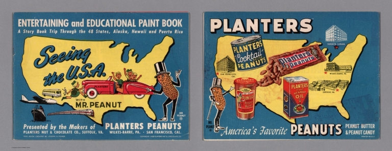
Author
[Fisher, Joseph R., Planters Peanuts (Firm)]
Full Title
(Covers to) Seeing the U.S.A. with Mr. Peanut : A story book trip through the 48 states, Alaska, Hawaii and Puerto Rico / presented by the makers of Planters Peanuts, Planters Nuts & Chocolate Co., Suffolk, Va. Wilkes-Barre, Pa. San Francisco, Cal. This book created by Joseph R. Fisher. Printed in U.S.A.
List No
14374.001
Note
Covers to Seeing the U.S.A. with Mr. Peanut. Bound in paper with a pictorial map of the United States on both the front and back covers, printed in color. Places of publication - Suffolk, Va., Wilkes-Barre, Pa. and San Francisco, Ca. highlighted on map. With illustrations of the character Mr. Peanut, as well as modes of transportation: car, bus, train, plane and ship. "Entertaining and educational paint book". Each cover is 20 x 27 cm, unfolded to 20 x 54 cm.
Author
[Fisher, Joseph R., Planters Peanuts (Firm)]
Full Title
(Text Page to) Mr. Peanut presents this paint book for your pleasure. Planters Nuts & Chocolate Co., Wilkes-Barre, Pa. Suffolk, Va. San Francisco, Calif. Toronto, Canada.
List No
14374.002
Note
Introductory text to Seeing the U.S.A. with Mr. Peanut, on verso of front cover. Text begins: Mr. Peanut is proud to bring you the story of the U.S.A. Rich farms, busy factories, abundant minerals... all have helped to make and keep America great. In this his latest paint book, Mr. Peanut takes you on a make-believe trip through the United States. With a map of the United States. Includes a table providing "Coloring hints".
Author
[A.J. Nystrom & Co., Dimond, Stanley, Beamer, Miles]
Full Title
1. Uncle Sam Grows Up
List No
15184.002
Author
[A.J. Nystrom & Co., Dimond, Stanley, Beamer, Miles]
Full Title
2. The United States - A Good Place to Live
List No
15184.003
Author
[A.J. Nystrom & Co., Dimond, Stanley, Beamer, Miles]
Full Title
5. The People of the United States
List No
15184.006
Author
[Bromme, Traugott, Buchner]
Full Title
Neueste Eisenbahn-Kanal-U. Post-Karte fur Reisende in den Vereinigten Staaten von Nord Amerika, Canada, Texas Sowie Californien Und Den Westlichen Staaten u. Gebieten. Nach J. Calvin Smith, H.S. Tanner u. andern neuessen Quellen bearbeitet. Verlag der Buchner'schen Buchhandlung in Bamberg. Stahlstich, Druck u. Illuminat. d. Kunst-u. geogr. Anst. v. Serz. & Cie. in Nurnberg. (upper right) Karte zu Tr. Bromes Handbuch f. Auswanderer. (with 6 inset maps).
List No
3357.002
Author
Wyld, James, 1812-1887
Full Title
The Atlantic Steam Packet Chart Shewing The Line Of Communication With North America And The West Indies &c. &c. By James Wyld Geographer To The Queen And Late H.R.H. Prince Albert. London, Published by Jas. Wyld ... Charing Cross East.
List No
3140.002
Note
Date estimated.
Author
Colton, G.W. & C.B.
Full Title
Colton's Map Of The United States Of America, The British Provinces, Mexico and the West Indies. Showing the Country from the Atlantic to the Pacific Ocean. Published by G.W. And C.B. Colton & Co. 172 William St. New York. 1871. (inset) The Eastern Portion Of The West India Islands ...
List No
3323.002
Author
Weiland, C. F. (Carl Ferdinand), 1782-1847
Full Title
Die Vereinigten Staaten von Nord America entworfen von C. F. Weiland. Weimar, im Verlag des Geograph. Instituts, 1828.
List No
14365.059
Note
Map of the United States, as of 1828. Shows political boundaries, cities, population, topography, bodies of water, drainage, coastlines, islands and territories of indigenous peoples. Relief shown with hachures. Includes latitudinal and longitudinal lines, as well as a legend and two bar scales. With hand-drawn annotation in blue colored pencil. Hand-colored engraving. Map is 30 x 43 cm, on sheet 45 x 57 cm. (Plate number taken from table of contents.)
Author
Desilver, Roberto
Full Title
Mapa de los Estados Unidos de America. Gridley, sc.
List No
14368.004
Note
Map of the United States. Shows political boundaries, cities, railways, canals, topography, bodies of water, drainage, coastlines and islands. Relief shown with hachures. Includes latitudinal and longitudinal lines, as well as a legend and bar scale. With title cartouche. Hand-colored engraving. Map is 33 x 42 cm, on double sheet 45 x 55 cm.
Author
[H.M. Gousha Company, McCauley Map Case Company]
Full Title
Road map of United States, prepared especially for McCauley Map Case Company, Detroit Michigan. Copyright 1939 by The H.M. Goushá Company, Chicago, Ill. Lithographed in U.S.A. (1)
List No
14335.001
Note
Road map of the United States. Shows political boundaries, cities, topography, deserts, lakes, drainage, coastline, national parks, monuments and time zone boundaries. Features major highways, as well as paved, improved, graded and dirt roads. Highlights main connecting roads and roads that become "bad during wet weather". Lithograph in blue, red and white. Printed vertically in four segments spanning the continental United States; rolled as a scroll on two wooden dowel, with scroll mounted in metal case, which is covered in tan leather. Map viewable through clear plastic lid section of case. Scroll format allows viewer to see different parts of map by winding red plastic knobs at the side of case. This section covers southern Georgia and northern Florida, and includes the title cartouche.
Author
[H.M. Gousha Company, McCauley Map Case Company]
Full Title
Road map of United States, prepared especially for McCauley Map Case Company, Detroit Michigan. Copyright 1939 by The H.M. Goushá Company, Chicago, Ill. Lithographed in U.S.A. (2)
List No
14335.002
Note
Road map of the United States. Shows political boundaries, cities, topography, deserts, lakes, drainage, coastline, national parks, monuments and time zone boundaries. Features major highways, as well as paved, improved, graded and dirt roads. Highlights main connecting roads and roads that become "bad during wet weather". Lithograph in blue, red and white. Printed vertically in four segments spanning the continental United States; rolled as a scroll on two wooden dowel, with scroll mounted in metal case, which is covered in tan leather. Map viewable through clear plastic lid section of case. Scroll format allows viewer to see different parts of map by winding red plastic knobs at the side of case. This section covers Boston, Massachusetts, on the northern edge to Washington, D. C., on the southern edge (part of Segment 1).
Author
[H.M. Gousha Company, McCauley Map Case Company]
Full Title
Road map of United States, prepared especially for McCauley Map Case Company, Detroit Michigan. Copyright 1939 by The H.M. Goushá Company, Chicago, Ill. Lithographed in U.S.A. (3)
List No
14335.003
Note
Road map of the United States. Shows political boundaries, cities, topography, deserts, lakes, drainage, coastline, national parks, monuments and time zone boundaries. Features major highways, as well as paved, improved, graded and dirt roads. Highlights main connecting roads and roads that become "bad during wet weather". Lithograph in blue, red and white. Printed vertically in four segments spanning the continental United States; rolled as a scroll on two wooden dowel, with scroll mounted in metal case, which is covered in tan leather. Map viewable through clear plastic lid section of case. Scroll format allows viewer to see different parts of map by winding red plastic knobs at the side of case. This section covers Sioux City, Iowa, on the western edge to Detroit, Michigan on the eastern edge, and includes the Great Lakes Region, with Chicago at the southern edge (part of Segment 2).
Author
[H.M. Gousha Company, McCauley Map Case Company]
Full Title
Road map of United States, prepared especially for McCauley Map Case Company, Detroit Michigan. Copyright 1939 by The H.M. Goushá Company, Chicago, Ill. Lithographed in U.S.A. (4)
List No
14335.004
Note
Road map of the United States. Shows political boundaries, cities, topography, deserts, lakes, drainage, coastline, national parks, monuments and time zone boundaries. Features major highways, as well as paved, improved, graded and dirt roads. Highlights main connecting roads and roads that become "bad during wet weather". Lithograph in blue, red and white. Printed vertically in four segments spanning the continental United States; rolled as a scroll on two wooden dowel, with scroll mounted in metal case, which is covered in tan leather. Map viewable through clear plastic lid section of case. Scroll format allows viewer to see different parts of map by winding red plastic knobs at the side of case. This section covers Denver, Colorado, on the northern edge to Oklahoma City, Oklahoma, on the southern edge, and includes the continental divide, as well as the “The Four Corners” (part of Segment 3).
Author
[H.M. Gousha Company, McCauley Map Case Company]
Full Title
Road map of United States, prepared especially for McCauley Map Case Company, Detroit Michigan. Copyright 1939 by The H.M. Goushá Company, Chicago, Ill. Lithographed in U.S.A. (5)
List No
14335.005
Note
Road map of the United States. Shows political boundaries, cities, topography, deserts, lakes, drainage, coastline, national parks, monuments and time zone boundaries. Features major highways, as well as paved, improved, graded and dirt roads. Highlights main connecting roads and roads that become "bad during wet weather". Lithograph in blue, red and white. Printed vertically in four segments spanning the continental United States; rolled as a scroll on two wooden dowel, with scroll mounted in metal case, which is covered in tan leather. Map viewable through clear plastic lid section of case. Scroll format allows viewer to see different parts of map by winding red plastic knobs at the side of case. This section covers San Francisco, California, on the western edge to Salt Lake City, Utah, on the eastern edge (part of Segment 4).
Author
[Passal, Daniela, Kennedy, John F.]
Full Title
A Nation of Immigrants.
List No
15132.001
Author
Granito, Lauren
Full Title
Computer Graphics: A view of the world
List No
15116.000
Author
[Raif Efendi, Mahmud, Faden, William (1749-1836)]
Full Title
(United States)
List No
15054.066
Note
For the source map by Faden see https://www.davidrumsey.com/luna/servlet/s/7c59vw
Author
Geological Survey (U.S.)
Full Title
The fifty states.
List No
14359.009
Note
World map highlighting the United States, as of 1970. Shows political boundaries, including those representing Alaska and Hawaii. With distances marked between Washington D. C. and San Francisco, Honolulu and Fairbanks. Colored lithograph. Map is 42 x 32 cm, on sheet 49 x 35 cm. Appears in General reference maps section.
Author
Geological Survey (U.S.)
Full Title
United States general reference. Compiled by U. S. Geological Survey.
List No
14359.010
Note
Map representing the United States, as of 1970. Shows political boundaries, cities, railways, roads, ferry lines, topography, deserts, swamps, bodies of water, drainage, coastlines and islands. Relief shown with shading and peak heights. Features population density for each city. Includes latitudinal and longitudinal lines, a legend, bar scale and scale statement. Presented with Albers Equal Area Projection. With two inset maps: Principal islands of Hawaii -- Alaska. Colored lithograph. Map is 43 x 66 cm, on double sheet 49 x 71 cm. Appears in General reference maps section.
Author
[Geological Survey (U.S.), Harrison, Richard Edes]
Full Title
Perspective views : Outlying areas : Pacific Area / Richard Edes Harrison -- Caribbean Area / Richard Edes Harrison.
List No
14359.011
Note
Two maps representing the Pacific and Caribbean areas, in relation to the United States, as of 1970. Maps show topography, bodies of water, drainage, coastlines and islands. Relief shown pictorially and with color coding. Maps include latitudinal and longitudinal lines. Colored lithograph. Maps are each 20 x 31 cm, on sheet 49 x 35 cm. Maps appear in General reference maps section.
Author
[Geological Survey (U.S.), Harrison, Richard Edes]
Full Title
Shaded relief / Richard Edes Harrison, 1969.
List No
14359.041
Note
Physical map representing the United States, featuring relief, as of 1969. Shows topography, bodies of water, drainage, coastlines and islands. Relief shown with color coding. Includes a legend, latitudinal and longitudinal lines, as well as a bar scale and scale statement. With two inset maps: Principal islands of Hawaii -- Alaska. Presented with Albers Equal Area Projection. Colored lithograph. Map is 43 x 66 cm, on double sheet 49 x 71 cm. Accompanying descriptive text on page 55. Appears in Special subject maps section, subsection Physical : Landforms.
Author
[Geological Survey (U.S.), Hammond, Edwin H.]
Full Title
Classes of land-surface form / adapted from Edwin H. Hammond, "Classes of land surface form in the forty-eight states, U. S.A.," Annals of the Assoc. of Am. Geographers, V. 54, no. 1, 1964, map supp. no. 4, 1:5,000,000.
List No
14359.045
Note
Physical map representing the United States, featuring different land surfaces, such as plains and mountains, as of 1964. Shows political boundaries, topography, bodies of water, drainage, coastlines and islands. Relief shown with color coding. Includes a legend, latitudinal and longitudinal lines, as well as a bar scale and scale statement. With two inset maps: Principal islands of Hawaii -- Alaska. Presented with Albers Equal Area Projection. Colored lithograph. Map is 43 x 66 cm, on double sheet 49 x 71 cm. Accompanying descriptive text on page 55. Appears in Special subject maps section, subsection Physical : Landforms.
Author
[Geological Survey (U.S.), U.S. Coast and Geodetic Survey, United States. Environmental Science Services Administration]
Full Title
Major recorded earthquakes / compiled by U. S. Geological Survey from 1965 data provided by U. S. Coast and Geodetic Survey, Environmental Science Services Administration.
List No
14359.048
Note
Physical map representing the United States, featuring major earthquakes according to intensity, as of 1965. Shows political boundaries, topography, bodies of water, drainage, coastlines and islands. Relief shown with shading. Includes a legend, latitudinal and longitudinal lines, as well as a bar scale and scale statement. With five inset maps: Inset 1 -- Inset 2 -- Inset 3 -- Principal islands of Hawaii -- Alaska. Presented with Albers Equal Area Projection. Colored lithograph. Map is 43 x 66 cm, on double sheet 49 x 71 cm. Accompanying descriptive text on page 55. Appears in Special subject maps section, subsection Physical : Geophysical forces.
Author
[Geological Survey (U.S.), Dolan, Robert, Bosserman, Kenton, Felder, Wilson]
Full Title
Coastal landforms / compiled by Robert Dolan, University of Virginia, assisted by Kenton Bosserman and Wilson Felder, 1967.
List No
14359.057
Note
Physical map representing the United States, featuring coastal landforms, as of 1967. Shows coastline configuration and composition, shoreline characteristics, political boundaries, topography, bodies of water, drainage, coastlines, islands and bathymetry. Relief shown with shading. Includes a legend, latitudinal and longitudinal lines, as well as a bar scale and scale statement. With six inset maps: 1. Sandy Hook to Cape Ann -- 2. Chesapeake Bay and vicinity -- 3. San Francisco Bay Area -- 4. Puget Sound and vicinity -- Principal islands of Hawaii -- Alaska. Presented with Albers Equal Area Projection. Colored lithograph. Map is 43 x 66 cm, on double sheet 49 x 71 cm. Appears in Special subject maps section, subsection Physical : Marine features.
Author
[Geological Survey (U.S.), United States. Naval Oceanographic Office]
Full Title
Sea temperature and salinity / compiled from information provided by U. S. Naval Oceanographic Office, 1968.
List No
14359.060
Note
Sixteen physical maps representing the United States, featuring ocean temperature and salinity, as of 1968. Maps show maximum, minimum and mean temperature in all four seasons, sea surface salinity, political boundaries, bodies of water, coastlines and islands. Maps include legends, as well as bar scales and scale statements. With two inset maps within each map: Principal islands of Hawaii -- Alaska. Colored lithograph. Maps are each 10 x 16 cm, on double sheet 49 x 71 cm. Accompanying descriptive text on page 80. Maps appear in Special subject maps section, subsection Physical : Marine features.
Author
[Geological Survey (U.S.), Küchler, A. W. (August William), 1907-1999]
Full Title
Potential natural vegetation / A. W. Küchler, University of Kansas, 1966.
List No
14359.066
Note
Physical map representing the United States, featuring vegetation, as of 1966. Shows soil vegetation (such as forests and grasslands), political boundaries, bodies of water, drainage, coastlines and islands. Includes legends, latitudinal and longitudinal lines, as well as a bar scale and scale statement. Presented with Albers Equal Area Projection. Colored lithograph. Map is 43 x 66 cm, on double sheet 49 x 71 cm. Accompanying descriptive text on page 89. Appears in Special subject maps section, subsection Physical : Soils.
Author
[Geological Survey (U.S.), United States. Environmental Data Service, United States. Environmental Science Services Administration]
Full Title
Mean monthly sunshine / prepared by U. S. Geological Survey in 1965 from Environmental Data Service, Environmental Science Services Administration records for the period 1931-1960 -- January -- February -- March -- April -- May -- June -- July -- August -- September -- October -- November -- December -- January / adapted from 1:30,000,000-scale maps by Environmental Data Service, Environmental Science Services Administration for the period 1931-1960.
List No
14359.069
Note
Thirteen physical maps representing the United States, featuring the monthly mean for sunshine, as well as monthly sunshine for each month of the year, based upon the period from 1931 to 1960. Maps also show political boundaries, bodies of water, drainage, coastlines and islands. Maps include a legend, as well as a bar scale and scale statements (scales differ). Presented with Albers Equal Area Projection. With two inset maps within each map: Principal islands of Hawaii -- Alaska. Colored lithograph. Together, maps are 42 x 65 cm, on double sheet 49 x 71 cm. Maps appear in Special subject maps section, subsection Physical : Climate.
Author
[Geological Survey (U.S.), United States. Environmental Data Service, United States. Environmental Science Services Administration]
Full Title
Monthly precipitation means and extremes / prepared by U. S. Geological Survey in 1965 from Environmental Data Service, Environmental Science Services Administration records for the period 1931-1960 -- January -- February -- March -- April -- May -- June -- July -- August -- September -- October -- November -- December -- January / adapted from 1:5,000,000-scale maps by Environmental Data Service, Environmental Science Services Administration for the period 1931-1960.
List No
14359.072
Note
Thirteen physical maps representing the United States, featuring the monthly mean for precipitation, as well as monthly precipitation for each month of the year, based upon the period from 1931 to 1960. Maps also show political boundaries, bodies of water, drainage, coastlines and islands. Maps include a legend, as well as a bar scale and scale statements (scales differ). Presented with Albers Equal Area Projection. With two inset maps within each map: Principal islands of Hawaii -- Alaska. Colored lithograph. Together, maps are 42 x 65 cm, on double sheet 49 x 71 cm. Maps appear in Special subject maps section, subsection Physical : Climate.
Author
[Geological Survey (U.S.), United States. Environmental Data Service, United States. Environmental Science Services Administration]
Full Title
Mean annual cooling degree-days, based on data for the period 1931-1960 -- Mean annual heating degree-days, based on data for the period 1931-1960 / adapted from 1:20,000,000-scale maps by Environmental Data Service, Environmental Science Services Administration.
List No
14359.079
Note
Two physical maps representing the United States, featuring mean annual cooling and heating degree days, based upon the period from 1931 to 1960. Maps also show political boundaries, bodies of water, drainage, coastlines and islands. Maps include legends, as well as bar scales and scale statements. Presented with Albers Equal Area Projection. With two inset maps within each map: Principal islands of Hawaii -- Alaska. Colored lithograph. Together, maps are 42 x 31 cm, on sheet 49 x 35 cm. Maps appear in Special subject maps section, subsection Physical : Climate.
Author
[Geological Survey (U.S.), Sturtevant, William C.]
Full Title
Early Indian tribes, culture areas, and linguistic stocks / William C. Sturtevant, Smithsonian Institution, 1967.
List No
14359.094
Note
Historical map representing the United States, featuring the territories and cultural areas and languages of early indigenous peoples, as of around 1899. Shows both major and minor tribes, political boundaries (present-day), bodies of water, drainage, coastlines and islands. Includes a legend, latitudinal and longitudinal lines, as well as a bar scale and scale statement. Presented with Albers Equal Area Projection. With two inset maps: Principal islands of Hawaii -- Alaska. Colored lithograph. Map is 43 x 66 cm, on double sheet 49 x 71 cm. Also, with bibliography for further reading. Accompanying descriptive text on page 132. Appears in Special subject maps section, subsection History.
Author
[Geological Survey (U.S.), Goetzmann, William H.]
Full Title
Exploration and settlement : 1850-1890 / compiled from information provided by William H. Goetzmann, Univertsity of Texas, 1966.
List No
14359.102
Note
Historical map representing the United States, featuring voyages of exploration and settlement from 1850 to 1890. Maps show the routes of explorers, settlements (including both colonial and indigenous), forts, railways, roads, trails, canals, mines, the extent of colonized area, topography, bodies of water, coastlines and islands. Relief shown with shading. Includes legends, as well as a bar scale and scale statement. With inset map: Alaska. Colored lithograph. Map is 20 x 30 cm, on sheet 49 x 35 cm. Accompanied by descriptive text, with references. Appears in Special subject maps section, subsection History.
Author
[Geological Survey (U.S.), Stoll, H. George, Hammond Incorporated]
Full Title
Territorial growth : 1775 -- 1790 -- 1800 -- 1810 -- 1820 -- 1830 -- 1840 -- 1850 -- 1860 -- 1870 -- 1880 -- 1900 -- 1920 -- United States and outlying areas : 1970 / compiled by H. George Stoll, Hammond Incorporated, 1967; rev. by U. S. Geological Survey, 1970.
List No
14359.103
Note
Fourteen historical maps representing the United States, featuring territorial expansion from 1775 - the time of the original thirteen colonies - to 1970, including territories beyond the continental. Maps show political boundaries, bodies of water, drainage, coastlines and islands. Maps include legends, as well as explanatory notes and a scale statement (scales differ). With an inset map within the maps dated 1870, 1880, 1900 and 1920: Alaska. Colored lithograph. Together, maps are 42 x 65 cm, on double sheet 49 x 71 cm. Maps appear in Special subject maps section, subsection History.
Author
[Geological Survey (U.S.), Hammond Incorporated]
Full Title
Presidential elections and political parties : 1796 -- 1800 -- 1804 -- 1808 -- 1812 -- 1816 -- 1820 -- 1824 -- 1828 -- 1832 -- 1836 -- 1840 -- 1844 -- 1848 -- 1852 -- 1856 -- 1860 -- 1864 -- 1868 -- 1872 -- 1876 -- 1880 -- 1884 -- 1888 -- 1892 -- 1896 -- 1900 -- 1904 -- 1908 -- 1912 -- 1916 -- 1920 -- 1924 -- 1928 -- 1932 -- 1936 -- 1940 -- 1944 -- 1948 -- 1952 -- 1956 -- 1960 -- 1964 -- 1968 / compiled by Hammond Incorporated, 1969.
List No
14359.105
Note
Forty-four historical maps representing the United States, featuring presidential elections and political parties from 1796 to 1968. Maps show political boundaries, bodies of water, coastlines and islands. Maps include legends and pie charts, as well as a scale statement. With two inset maps within the maps dated 1960, 1964, and 1968: Hawaii -- Alaska. Also, with a timeline of presidents, from Washington to Nixon. Colored lithograph. Together, maps are 42 x 65 cm, on double sheet 49 x 71 cm. Accompanying descriptive text on page 129. Maps appear in Special subject maps section, subsection History.
Author
[Geological Survey (U.S.), United States. Department of Agriculture, United States. Soil Conservation Service, United States. Department of Agriculture. Economic Research Service, United States. Farmers Home Administration]
Full Title
Soil conservation service programs by farm production regions : 1966 / compiled from information provided by U. S. Soil Conservation Service, 1967 -- Conservation payments by farm production regions : 1966 / compiled from Economic Research Service, Farm income situation, FIS-205, Washingon, U. S. Dept. of Agric., 1967, table 10 -- Commodity credit corporation loans : cumulative 1933-1965 / compiled from U. S. Dept. of Agriculture, Agriculture statistics: 1966, Washington, U. S. Govt. Print. Off., 1966, table 748 -- Payments for selected programs by farm production regions : 1966 / compiled from Economic Research Service, Farm income situation, FIS-205, Washingon, U. S. Dept. of Agric., 1967, table 10 -- Farmers home administration and rural electrification administration loans by farm production regions : 1966 / compiled from U. S. Dept. of Agriculture, Agriculture statistics: 1966, Washington, U. S. Govt. Print. Off., 1966, tables 740 and 741; and information provided by Farmers Home Administration, 1968.
List No
14359.124
Note
Five economic maps representing the United States, featuring agricultural conservation programs, payments and loans, as of 1966. Maps also show political boundaries, bodies of water, coastlines and islands. Maps include legends, as well as bar scales and scale statements (scales differ). Presented with Albers Equal Area Projection. With two inset maps within each map: Principal islands of Hawaii -- Alaska. Colored lithograph. Together, maps are 42 x 31 cm, on sheet 49 x 35 cm. Maps appear in Special subject maps section, subsection Economic : Agriculture.
Author
Geological Survey (U.S.)
Full Title
Oil production and reserves : 1966 -- Natural gas production and reserves : 1966 -- Natural gas liquids production and reserves : 1966 -- Coal production and reserves, anthracite, bituminous, and lignite : 1966 / compiled by U. S. Geologic Survey, 1968 -- Oil shale and tar sands : 1965 -- Nuclear materials : 1967 -- Organic fuels, production and consumption : Total petroleum production, billion barrels of crude oil equivalent -- Oil production, billion barrels -- Gas production, trillion cubic feet -- Coal production, million short tons -- Oil consumption -- Gas consumption -- Coal consumption.
List No
14359.136
Note
Six mineral maps and seven charts representing the United States, featuring the geographic locations of energy materials - such as oil, natural gas and coal - as of 1967. Maps show the production and reserves of energy materials, as well as political boundaries, bodies of water, coastlines and islands. Maps include legends, as well as bar scales and scale statements. Presented with Albers Equal Area Projection. With two inset maps within each map: Principal islands of Hawaii -- Alaska. Charts show production and consumption. Colored lithograph. Together, maps and charts are 42 x 31 cm, on sheet 49 x 35 cm. Accompanying descriptive text on page 177. Maps and charts appear in Special subject maps section, subsection Economic : Mineral and energy resources.
|