|
REFINE
Browse All : Images of U.S. South
1-148 of 148
Author
Wyld, James, 1812-1887
Full Title
The Atlantic Steam Packet Chart Shewing The Line Of Communication With North America And The West Indies &c. &c. By James Wyld Geographer To The Queen And Late H.R.H. Prince Albert. London, Published by Jas. Wyld ... Charing Cross East.
List No
3140.002
Note
Date estimated.
Author
[Wytfliet, Corneille, Magini, Giovanni Antonio]
Full Title
Florida et Apalche. (to accompany) Histoire universelle des Indes occidentales et orientales, et de la conversion des Indiens : divisee en trois parties par Cornille Wytfliet & Anthoine Magin & autres historiens. Premiere Partie. A Douay, Chez Francois Fabri, l'An 1611.
List No
11622.055
Note
Uncolored engraved double page map of Florida and the Southeast Coast of North America, part of Cuba and Bahamas. Shows cities, towns, landmarks, rivers, forests and mountains. Relief shown pictorially. Includes decorative title cartouche.
Author
Robert Sayer and John Bennett (Firm)
Full Title
A General Map of the Southern British Colonies, in America. containing North and South Carolina, Georgia, East and West Florida, with the Neighbouring Indian Countries. From the Modern Surveys of Engineer de Brahm, Capt. Collet, Mouzon & Others; and from the Large Hydrographical Survey of the Coasts of East and West Florida. By B. Romans, 1776. (with) Plan of Charleston and ... St. Augustine. London: Printed for R. Sayer & J. Bennett ... 15th Octr. 1776.
List No
0875.005
Note
In outline color. Above the map reads, "The Seat of War in the Southern British Colonies comprehending North and South Carolina, Georgia, East and West Florida, &ca."
Author
Smiley, Thomas T.
Full Title
Southern States. (with) South Part of Florida.
List No
0902.006
Note
In full color by state. Uncolored vignette showing a variety of ships and entitled "Commerce of the Southern States."
Author
Magnus, Charles
Full Title
Panorama Of The Mississippi Valley And Its Fortifications. Published by C. Magnus, 12 Frankfort Street, New York. Eng. by F.W. Boell.
List No
2397.000
Note
Date is Stephenson's; there is no date on map. Four vignettes; attractive hand-painted color. Map includes table of distances to various points on the Mississippi from St. Louis to New Orleans.
Author
Popple, Henry
Full Title
A Map of the British Empire in America with the French and Spanish Settlements adjacent thereto. by Henry Popple. (Sheet 9).
List No
2874.011
Note
Northern Mexico, New Mexico, and Louisiana shown. The area around Santa Fe is especially detailed with the Spanish settlements noted all along the Rio Grande. Uncolored.
Author
Popple, Henry
Full Title
A Map of the British Empire in America with the French and Spanish Settlements adjacent thereto. by Henry Popple. (Sheet 10).
List No
2874.012
Note
An uncolored portion showing the region from Virginia south to Florida. Counties are named, forts are identified, and Indian tribes noted.
Author
[Mitchell, John, Raynal, G.T., Zatta, Antonio]
Full Title
Luigiana Inglese, colla Parte Occidentale della Florida, della Giorgia, e Carolina Meridonale. Fogl. X.
List No
5007.012
Note
In outline color.
Author
Cornell, S. S. (Sarah S.)
Full Title
Southern and Western States. Designed to accompany Cornell's High school geography. Entered ... 1855, by S.S. Cornell ... Southern District of New York. New York: D. Appleton & Co., 443 & 445 Broadway. (1864)
List No
0197.009
Note
Engraved map. Hand colored. Relief shown by hachures. Prime meridians: Greenwich and Washington.
Author
Cornell, S. S. (Sarah S.)
Full Title
Eastern division of the United States. Designed to accompany Cornell's High school geography. Drawn by E. Wells, N.Y. Entered ... 1856, by S.S. Cornell ... Southern District of New York. New York: D. Appleton & Co., 443 & 445 Broadway. (1864)
List No
0197.013
Note
Engraved map. Hand colored. Relief shown by hachures. Prime meridians: Greenwich and Washington. "Reference map."
Author
Cornell, S. S. (Sarah S.)
Full Title
Southern division of the United States. Designed to accompany Cornell's High school geography. Drawn by J. Wells, N.Y. Entered ... 1856, by S.S. Cornell ... Southern District of New York. New York: D. Appleton & Co., 443 & 445 Broadway. (1864)
List No
0197.014
Note
Engraved map. Hand colored. Relief shown by hachures. Prime meridians: Greenwich and Washington. "Reference map."
Full Title
The Middle States, Maryland & Virginia. J.H. Young Sc. (Philadelphia: John Grigg, No. 9 North Fourth Street. 1830)
List No
0315.006
Note
Engraved map. Full hand color. Relief shown pictorially. Prime meridians: Greenwich and Washington.
Author
Johnston, Alexander Keith, 1804-1871
Full Title
United States of North America, eastern states, by Keith Johnston, F.R.S.E. Engraved & printed by W. & A.K. Johnston, Edinburgh. William Blackwood & Sons, Edinburgh & London, (1861)
List No
0373.051
Note
Engraved map. Boundaries hand col.; hydrography printed in blue. Relief shown by hachures and spot heights. "Keith Johnston's general atlas 45."
Author
Melish, John
Full Title
Southern Section of the United States including Florida &c. by John Melish. Entered ... by John Melish ... 1 March 1813.
List No
0495.008
Note
Large fold-out map in outline color. A small inset map of the Bermudas Isles is included. A statistical chart is included showing population and state area.
Author
Mitchell, Samuel Augustus
Full Title
Map of the Southern States. Engraved to Illustrate Mitchell's School and Family Geography. No. 8. Engraved by W. Williams. Entered ... 1839, by S. Augustus Mitchell ... Connecticut.
List No
0523.006
Note
In full color by state. Includes explanation of symbols used to represent towns, railroads, canals and distance.
Author
Morse, Jedidiah
Full Title
A Map of the States of Virginia, North Carolina, South Carolina, and Georgia; Comprehending the Spanish Provinces of East and West Florida: Exhibiting the Boundaries as fixed by the late Treaty of Peace between the United States and the Spanish Dominions. Compiled from late Surveys & Observations by Joseph Purcell. W. Harrison Senr. & Junr. sc. Engraved for Morse's Geography. Publish'd by John Stockdale Jany. 25th 1792.
List No
0632.014
Note
Map shows the boundaries between the United States and the Spanish Dominions, the individual states, and the territories claimed by the Indian nations. Map without color.
Author
Perrine, Charles O.
Full Title
(Covers to) Perrine's New Military Map Illustrating The Seat of War. Entered according to Act of Congress, in the year 1862, by C. O. Perrine, in the Clerk's Office of the District Court of the State of Indiana. (with) Inset map of Southern Part of Florida.
List No
0706A
Author
Perrine, Charles O.
Full Title
Perrine's New Military Map Illustrating The Seat of War. Entered according to Act of Congress, in the year 1862, by C. O. Perrine, in the Clerk's Office of the District Court of the State of Indiana. (with) Inset map of Southern Part of Florida.
List No
0706.001
Note
With cardboard orange covers 14x9 entitled "Perrine's New Military Map Illustrating The Seat of War. Mumford & Co., 38 and 40 Fourth Street, Cleveland, Ohio. 1862." Printed outline color in yellow.
Author
Phelps & Watson
Full Title
(Covers to) Phelps & Watson's Historical And Military Map Of The Border & Southern States. Published By Phelps & Watson, 16 Beekman St. New York. 1864 ... Entered ... 1862 by Phelps & Watson ... New York.
List No
0716.001
Note
Civil War Map, updated to Aug 9, 1864. Full color by state. Map is folded into orange card board covers 17x11 with "New Historical War Map" printed in black.
Author
Phelps & Watson
Full Title
Phelps & Watson's Historical And Military Map Of The Border & Southern States. Published By Phelps & Watson, 16 Beekman St. New York. 1864 ... Entered ... 1862 by Phelps & Watson ... New York.
List No
0716.002
Note
Civil War Map, updated to Aug 9, 1864. Full color by state. Map is folded into orange card board covers 17x11 with "New Historical War Map" printed in black.
Author
Phelps & Watson
Full Title
(Covers to) Phelps & Watson's Historical And Military Map Of The Border & Southern States. Published By Phelps & Watson, 16 Beekman St. New York. 1864 ... Entered ... 1862 by Phelps & Watson ... New York.
List No
0717.001
Note
Updated to Oct 1, 1864. Full color by state. Map is folded into orange card board covers 17x11 with "New Historical War Map" printed in black.
Author
Phelps & Watson
Full Title
Phelps & Watson's Historical And Military Map Of The Border & Southern States. Published By Phelps & Watson, 16 Beekman St. New York. 1864 ... Entered ... 1862 by Phelps & Watson ... New York.
List No
0717.002
Note
Updated to Oct 1, 1864. Full color by state. Map is folded into orange card board covers 17x11 with "New Historical War Map" printed in black.
Author
Pinkerton, John, 1758-1826
Full Title
United States of America, southern part. Drawn under the direction of Mr. Pinkerton by L. Hebert. Neele sculpt. 352 Strand. London: published Octr. 5th. 1809, by Cadell & Davies, Strand & Longman, Hurst, Rees, Orme, & Brown, Paternoster Row.
List No
0732.044
Note
Engraved map. Full hand col. Relief shown by hachures. "Pinkerton's modern atlas."
Author
Society for the Diffusion of Useful Knowledge (Great Britain)
Full Title
North America sheet VII. Pennsylvania, New Jersey, Maryland, Delaware, Columbia and part of Virginia. Published under the superintendence of the Society for the Diffusion of Useful Knowledge. J. & C. Walker sculpt. Published July 15th. 1833 by Baldwin & Cradock, 47 Paternoster Row, London. Printed by J. & C. Walker. (London: Chapman & Hall, 1844)
List No
0890.134
Note
Engraved map. Relief shown by hachures. County boundaries hand col. Source: Tanner, Gordon.
Author
Society for the Diffusion of Useful Knowledge (Great Britain)
Full Title
North America sheet X. Parts of Missouri, Illinois, Kentucky, Tennessee, Alabama, Mississippi and Arkansas. Published under the superintendence of the Society for the Diffusion of Useful Knowledge. J. & C. Walker sculpt. Published by Baldwin & Cradock, 47 Paternoster Row, 1st. Decr. 1833. (London: Chapman & Hall, 1844)
List No
0890.137
Note
Engraved map. Relief shown by hachures. County boundaries hand col. Source: Tanner.
Author
Society for the Diffusion of Useful Knowledge (Great Britain)
Full Title
North America sheet XII. Georgia with parts of North & South Carolina, Tennessee, Alabama & Florida. Published under the superintendence of the Society for the Diffusion of Useful Knowledge. J. & C. Walker sculpt. Published Novr. 1st. 1833 by Baldwin & Cradock, 47 Paternoster Row, London. Printed by Russell, Penge. (London: Chapman & Hall, 1844)
List No
0890.139
Note
Engraved map. Relief shown by hachures. County boundaries hand col.
Author
Society for the Diffusion of Useful Knowledge (Great Britain)
Full Title
North America sheet XIII. Parts of Louisiana, Arkansas, Mississippi, Alabama & Florida. Published under the superintendence of the Society for the Diffusion of Useful Knowledge. Engraved by J. & C. Walker. Published June 1st. 1833 by Baldwin & Cradock, 47 Paternoster Row, London. (London: Chapman & Hall, 1844)
List No
0890.140
Note
Engraved map. Relief shown by hachures. County boundaries hand col. Source: Tanner.
Author
Thomson, John
Full Title
Southern provinces of the United States. (with view) Characteristic scenery of the Hudson River. Hewitt sc., Grafton Str. East, Tottenham Court Rd. Drawn & engraved for Thomson's New general atlas, 1817.
List No
1007.063
Note
Engraved map. Hand colored. Relief shown by hachures. Shows settlements, Indian tribes, etc.
Author
[Touring club italiano, Funk & Wagnalls Company.]
Full Title
(Legend to) Stati Uniti, United States of America, Arkansas, Tennessee, Louisiana, Mississippi, Florida, Alabama, Georgia, South Carolina. Propr. Artistico-letteraria del T.C.I. Ufficio cartografico del T.C.I. (1929)
List No
1012CU
Note
Explanation to map.
Author
[Touring club italiano, Funk & Wagnalls Company.]
Full Title
Stati Uniti, United States of America, Arkansas, Tennessee, Louisiana, Mississippi, Florida, Alabama, Georgia, South Carolina. Propr. Artistico-letteraria del T.C.I. Ufficio cartografico del T.C.I. (1929)
List No
1012.078
Note
Color map. Relief shown by hachures and spot heights; depths by isolines. Includes inset of New Orleans at 1:250,000 scale and another that is continuation of main map.
Author
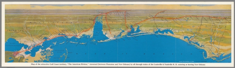
Louisville & Nashville R.R.
Full Title
Map of the attractive Gulf Coast territory, "The American Riviera" traversed (Between Flomaton and New Orleans) by all through trains of the Louisville & Nashwille R.R. entering or leaving New Orleans. Copyright 1926, by Pool Bros., Inc. Chicago. (Cover title) Between the north and New Orleans : via the beautiful Gulf Coast, Over the Louisville & Nashville R.R.
List No
11140.002
Note
Panoramic map of the Gulf Cost "The American Riviera" on sheet 23x81, folded into 23x10 Showing the Louisville & Nashville railroad route from New Orleans to Apalachicola. Includes place names, cities and towns. On verso: pictorial cover, text: "The Louisville & Nashville Railroad", uncolored route map, black and white photos of scenic views.
Author
[Whitney-Graham Company, Inc., Southern Railway (U.S.), Funk & Wagnalls Company.]
Full Title
Map of the Southern railway system. 1929. The Southern Railway. 2-29. (to accompany) The blue book of map making : America's map makers. R.W.C. The Whitney-Graham Co. Inc. (insets) Southern Florida. (with) Cuba.
List No
11489.020
Note
Color map of the Southern and Eastern States. Showing state boundaries, cities, towns and roads. Southern Railway single and double tracks in red and tracks operated separately shown in blue. Includes station index and legend.
Author
Zatta, Antonio, active 1757-1797
Full Title
Luigiana Inglese, colla Parte Occidentale della Florida, della Giorgia, e Carolina Meridonale. Le Colonie Unite dell' America Settentrle. Fogl. X. (to accompany) Atlante novissimo ... Tomo IIII. Con privilegio dell Eccelimo Senato. (tomo I-IV).
List No
11598.234
Note
Engraved hand-colored in outline, double-page map. The first edition of Zatta's twelve sheet version of Mitchell's Map of North America, plus three other maps: Il Canada, La Baja D' Hudson, and Le Isole di Terra Nuova e Capo Breton. Zatta's version of Mitchell is not an exact copy: many geographical changes are introduced, and Bermuda is depicted as well as Jamaica, neither of which are shown by Mitchell. Maps showing administrative divisions, settlements, cities, towns, forts, Indian settlements, bridges, canals, mountains and rivers. Relief shown pictorially and by hacures. Includes notations.
Author
Meyer, Joseph, 1796-1856
Full Title
(United States of North America) : Die Staaten von N. & S. Carolina, Georgia & Florida. 1850. Aus der Geograph. Graviranstalt des Bibliograph. Instituts zu Hildburghausen. (in upper margin) Meyer's Zeitung Atlas. No. 76. (to accompany) Neuester Zeitungs-Atlas fur Alte und Neue Erdkunde. Herausgegeben von J. Meyer. (insets) Hafen von St. Augustine. (with) Gold-Region von Nord-Carolina. (with) Newberne. (with) Charleston.
List No
11652.095
Note
Engraved outline hand color map. Shows administrative boundaries, cities and towns. Relief shown by hachures. Prime meridians are Greenwich and Washington.
Author
[Santini, Paolo, d'Anville]
Full Title
48. Partie Meridionale de la Louisiane, avec la Floride, la Caroline et la Virginie.
List No
12039.131
Author
Woodbridge, William C.
Full Title
Physical & Political Map Of the Southern Division Of The United States. Adapted To Woodbridge's Geography. Entered ... 1843, by W.C. Woodbridge ... Massachusetts. Hartford. Published By Wm. Jas. Hamersley. (to accompany) Modern Atlas, Physical, Political And Statistical; Exhibiting On Separate Maps ... (inset map) Vicinity of Charleston. (inset map) vicinity of New Orleans.
List No
1229.015
Note
Full color color. Includes References and Explanations showing Cities, Inhabitants, Small and Large towns, Universities or Colleges, Capitals, Canals and Railways, Head of navigation of Rivers. Covers are heavy brown paper printed with "School Atlas, To Accompany The Modern School Geography, By William C. Woodbridge ... Hartford: Published By Belknap & Hamersley. Entered ... 1843, by William C. Woodbridge ... Massachusetts. Case, Tiffany & Co. Printers, Hartford, Conn." Prime meridians are Greenwich and Washington D.C. Relief shown by hachures.
Author
Woodbridge, William C.
Full Title
Physical & Political Map Of The Southern Division Of the United States. Adapted To Woodbridge's Geography. Entered .. . 1843, by W.C. Woodbridge ... Massachusetts. Hartford. Published By Wm. Jas. Hamersley. (inset map) Vicinity of Charleston. (inset map) Vicinity of New Orleans.
List No
1231.015
Note
Full color map. Includes References and Explanations, showing Cities, Inhabitants, Universities or Colleges, Canals and Railways. Covers are heavy brown paper printed with "School Atlas, To Accompany The Modern School Geography, By William C. Woodbridge ... Hartford: Published By Wm. Jas. Hamersley. Entered ... 1843, by William C. Woodbridge ... Massachusetts. Case, Tiffany & Co. Printers, Hartford, Conn." Prime meridians are Greenwich and Washington D.C. Relief shown by hachures.
Author
Wyld, James, 1812-1887
Full Title
(Covers to) Wyld's Military Map Of The United States, The Northern States, And The Southern Confederate States: With The Forts, Harbours, Arsenals And Military Positions. James Wyld, 457 Strand; Charing Cross East And 2, Royal Exchange London. London, Published By James Wyld, Geographer To The Queen & H.R.H. The Prince Consort ... (with 4 inset maps).
List No
1246A
Author
Wyld, James, 1812-1887
Full Title
Wyld's Military Map Of The United States, The Northern States, And The Southern Confederate States: With The Forts, Harbours, Arsenals And Military Positions. James Wyld, 457 Strand; Charing Cross East And 2, Royal Exchange London. London, Published By James Wyld, Geographer To The Queen & H.R.H. The Prince Consort ... (with 4 inset maps).
List No
1246.001
Note
Stephenson copy is dated 1861; this is undated. Excellent detail, several insets. Chippewa is a state above Dakotah. Paste down advertising catalogue for maps, atlases and globes. Inset maps include: City Of Washington And District Of Columbia, Country Round Washington, Pensacola Bay and its Fortifications, Charleston And The Harbour. Map is dissected into 25 sections and mounted on linen. Outline color by state and military position. Map folds into brown cloth covered boards 21.5x13.5 with a paste down label reading "Wyld's New Map Of The United States. James Wyld, Geographer To The Queen, & H.R.H. The Prince Consort, 457, Strand, Charing Cross East, S.W. Opposite Northumberland Street; And 2, Royal Exchange, E.C. London." A remnant of a label on the spine appears to read "United States".
Author
Nicollet, Joseph Nicolas, 1786-1843
Full Title
Hydrographical Basin of the Upper Mississippi River : From Astronomical and Barometrical Observations Surveys and Information : by J.N. Nicollet, in the years 1836, 37, 38, 39, and 40 ; assisted in 1838,39, & 40, by Leiut. J.C. Fremont ... Reduced and compiled under the direction of Col. J.J. Abert ... by Lieut. W.H. Emory from the map published in 1842 and from other authorities in 1843. Published by order of the U.S. House of Representatives. C.B. Graham's Lithy.
List No
13071.000
Note
This map is the earliest accurate mapping of the region of the Northern Plains and Upper Mississippi River. Lithographed by C. B. Graham. Extends from St. Louis north to the Canadian Border, and west along the Missouri River. Printed on two sheets, joined. The map is based upon a series of systematic instrument surveys conducted by Nicollet, assisted by Lt. John Charles Fremont, of the Army Corps of Topographical Engineer. His map was years ahead of its time, with its regional concept and sound basis in instrument readings and astronomically determined points. Had he lived longer, Nicollet would undoubtedly have become the official government cartographer of the whole trans-Mississippi West. This copy is the House of Reprentatives issue. See our 2488.000 for the Senate issued, which appears identical except for the lithographer.
Author
Romans, Bernard
Full Title
A general map of the Southern British colonies in America, comprehending South Carolina, Georgia, East and West Florida ... by B. Romans. Reprinted 1937 by U.S. Geological Survey. (in upper margin) Georgia at the time of the ratification of the Constitution, from original maps ... Issued by the United States Constitution Sesquicentennial Commission.
List No
13081.018
Note
Map of Georgia. Insets: The settled portion of Georgia and The correct southern boundary of Georgia in 1787. Relief shown pictorially. Prime meridian is London. Includes historical text, tables and explanation. Series: "This map is one of a series of similar colored maps, depicting the 13 original states, from New Hampshire to Georgia at the time of the formation of the Constitution ..."
Author
[Sydow, Emil von., 1812-1873, Wagner, Hermann, 1840-1929]
Full Title
Ostliche Vereinigte Staaten. Gotha : Justus Perthes. Sydow-Wagners method. Schul-Atlas. XXI.
List No
13557.141
Note
Map of the Eastern States. With inset: Neu-York u. ungenbung. Albers equal-area conic projection.
Author
[Sydow, Emil von., 1812-1873, Wagner, Hermann, 1840-1929]
Full Title
Ostliche Vereinigte Staaten. Gotha : Justus Perthes. Sydow-Wagners method. Schul-Atlas. XXII.
List No
13558.144
Note
Map of the Eastern States. Albers equal-area conic projection.
Author
[Sydow, Emil von., 1812-1873, Wagner, Hermann, 1840-1929]
Full Title
Ostliche Vereinigte Staaten. Gotha : Justus Perthes. Sydow-Wagners method. Schul-Atlas. XXIII.
List No
13559.152
Note
Map of the Eastern and part of Southern States. Albers equal-area conic projection.
Author
Stieler, Adolf, 1775–1836
Full Title
Petermann : Vereinigte Staaten Von Nord-Amerika In 6, Bl. 5. Bearbeitet v. H. Habenicht. Gest v. Metzeroth, Eberhardt, Kuhn & Kramer. Stieler's Hand-Atlas No. 85. Gotha: Justus Perthes. 1875.
List No
13563.108
Note
1 outline color map on 6 sheets. Sheet 5. Title from sheet 4. Shows Kansas, Indian Territory, Arkansas, Louisiana and parts of Texas and Missouri.
Author
Stieler, Adolf, 1775–1836
Full Title
Petermann : Vereinigte Staaten Von Nord-Amerika In 6, Bl. 6. Bearbeitet v. H. Habenicht. Gest v. Eberhardt, Kuhn, Metzeroth u. Weiler. Stieler's Hand-Atlas No. 86. Gotha: Justus Perthes. 1875.
List No
13563.109
Note
1 outline color map on 6 sheets. Sheet 6. Title from sheet 4. Inset maps: Der sudlichd theil von Florida. Sudliche theil von Texas. Shows Southern States, Florida, Georgia, Alabama, Tennessee, Kentucky Virginia, North and South Carolina.
Author
Waldmire, Robert, 1945-2009
Full Title
Cox Newspapers USA. Artwork by Robert Waldmire. Copyright 1978. Pennysaver, Inc., Phoenix, Az.
List No
13633.000
Author
[3, Soviet Union. Glavnoe upravlenie geodezii i kartografii]
Full Title
Юго-Восток США = IUgo-Vostok Ssha. 236-237. Atlas Mira : 1954.
List No
13682.250
Note
Physical map of the Southeast of the United States. Showing state boundaries. Relief shown by shadings and spot heights. Depths shown by gradient tints, isolines and soundings.
Author
[3, Soviet Union. Glavnoe upravlenie geodezii i kartografii]
Full Title
Центральная Часть Юга США = Tsentral'naia Chast' IUga SShA. 239-240. Atlas Mira : 1954.
List No
13682.253
Note
Map of South Central of the United States. Showing state boundaries. Relief shown by shadings, contours and spot heights. Depths shown by gradient tints, isolines and soundings.
Author
Bartholomew, John
Full Title
(Index to) U.S.A. South-East. Lambert Conformal Conic Projection, Standard Parallels 33 (degrees) and 45 (degrees) N. 1:2,500,000.
List No
1552.271
Note
Uncolored index map. With key to adjoining areas.
Author
Bartholomew, John
Full Title
U.S.A. South-East. The Geographical Institute Edinburgh. Edited by John Bartholomew, M.C. LL. D. Copyright - John Bartholomew & Son, LTD. (inset map) New Province.
List No
1552.272
Note
Full color map. Relief shown by shadings and spot heights. Depth shown by shadings and soundings. Prime meridian is Greenwich. No. 1440 and Sep. 55 marked on the lower corners of plate. The Times Atlas on the upper left corner.
Author
Cary, John, ca. 1754-1835
Full Title
A new map of part of the United States of North America, containing those of New York, Vermont, New Hampshire, Massachusets (sic), Connecticut, Rhode Island, Pennsylvania, New Jersey, Delaware, Maryland and Virginia. From the latest authorities. By John Cary, engraver. 1806. London: Published by J. Cary, Engraver & Map-seller, No. 181, Strand, Sept. 1, 1806.
List No
1657.057
Note
Engraved map. State boundaries in outline hand col. Relief shown pictorially. "55" pasted on verso.
Author
Cary, John, ca. 1754-1835
Full Title
A new map of part of the United States of North America, containing the Carolinas and Georgia, also the Floridas and part of the Bahama Islands &c. From the latest authorities. By John Cary, engraver. 1806. London: Published by J. Cary, Engraver & Map-seller, No. 181, Strand, Feby. 1st, 1806.
List No
1657.059
Note
Engraved map. State boundaries in outline hand col. Relief shown pictorially. "57" pasted on verso.
Author
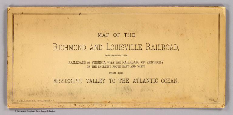
G.W. & C.B. Colton & Co.
Full Title
(Covers to) Map of the Richmond and Louisville R.R. connecting the railroads of Virginia with the railroads of Kentucky on the shortest route east and west from the Mississippi Valley to the Atlantic Ocean. Engraved, printed and manufactured by G.W. & C.B. Colton & Co. No. 182 William St. New York. Entered ... 1882 by G.W. & C.B. Colton & Co. ... at Washington.
List No
1702A
Note
Heavy beige paper covers printed with the title: Map of the Richmond and Louisville Railroad, connecting the railroads of Virginia with the railroads of Kentucky on the shortest route east and west from the Mississippi Valley to the Atlantic Ocean.
Author
G.W. & C.B. Colton & Co.
Full Title
Map of the Richmond and Louisville R.R. connecting the railroads of Virginia with the railroads of Kentucky on the shortest route east and west from the Mississippi Valley to the Atlantic Ocean. Engraved, printed and manufactured by G.W. & C.B. Colton & Co. No. 182 William St. New York. Entered ... 1882 by G.W. & C.B. Colton & Co. ... at Washington.
List No
1702.001
Note
Relief shown by hachures. Outline color by state with railroads colored in red and blue.
Author
[Duane, James C., United States. War Department]
Full Title
Map showing the operations of the Army of the Potomac under command of Maj. Gen. George G. Meade, from March 29th to April 9th, 1865. J.C. Duane, Major of Engineers ... (with) Map of portions of Mississippi, Alabama and Georgia showing march of Cavalry Corps, Military Division of the Mississippi, from March 22d to April 20th 1865. (with) No. 3. Map showing routes of marches of the army of Gen. W.T. Sherman from Atlanta, Ga. to Goldsborough, N.C. ... (with) Plat showing the battle-ground at Rivers' Bridge, Big Salkehatchie River, S.C. (with) Chart accompanying project for effectually closing Cape Fear River and the port of Wilmington, N.C. to blockade runners. (with) Plans, sections and elevation of pile bridge, James River near Varina, Va., January 1865. W.R. King, 1st Lieut. U.S. Engrs. ... Julius Bien & Co., Lith., N.Y. (1891-1895)
List No
1780.076
Note
Col. map with 4 ancillary maps and 1 panel of sections. Accompany reports and letters of of J.H. Wilson, O.O. Howard, Q.A. Gillmore and George G. Meade
Author
[Jenney, William LeB., United States. War Department]
Full Title
Military map of the marches of the United States forces under command of Maj. Gen. W.T. Sherman, U.S.A. during the years 1863, 1864, 1865. Compiled by order of Maj. Gen. W.T. Sherman ... under the direction of Bvt. Maj. W.L.B. Jenney ... Drawn by Capt. William Kossak ... and John B. Muller, draughtsman. St. Louis, Mo., 1865. Julius Bien & Co., Lith., N.Y. (1891-1895)
List No
1780.117
Note
Col. map. Relief shown by hachures. Shows settlements, roads, railroads, fortifications, etc.
Author
[Ruger, Edward, United States. War Department]
Full Title
Map prepared to exhibit the campaigns in which the Army of the Cumberland took part during the War of the Rebellion. By order of Maj. Gen. Geo. H. Thomas, U.S.A. Compiled under the direction of Bvt. Maj. Gen. Z.B. Tower, Chief Engr., Milit. Div. of the Tenn., by Ed. Ruger ... Assistants: Capt. A. Kilp and Lieut. R. Flach ... (with) Map illustrating the operations of the Seventh Division under Brig. Gen. G.W. Morgan at Cumberland Gap, Tenn., during a portion of the year 1862. Compiled by Edward Ruger ... 1877 (with) Map of the environs of Petersburg, Va., from the Appomattox River to Ft. Howard, showing the positions of the entrenched lines occupied by the Ninth Army Corps, A.P. during the siege. Julius Bien & Co., Lith., N.Y. (1891-1895)
List No
1780.118
Note
Col. map with 2 ancillary maps. Relief shown by hachures.
Author
[Colton, G.W., United States. War Department]
Full Title
Section of G. Woolworth Colton's new guide map of the United States and Canada with railroads, counties, etc. 1863. Used by General Grant in marking the proposed lines of operations of the armies of the United States, in 1864. Julius Bien & Co., Lith., N.Y. (1891-1895)
List No
1780.136
Note
Col. map. "Counties and unimportant places appearing on the original map are here omitted."
Author
[Julius Bien & Co., United States. War Department]
Full Title
General topographical map. Sheet I. Julius Bien & Co., Lith., N.Y. (1891-1895)
List No
1780.139
Note
Col. map. Relief shown by hachures. Shows settlements, railroads, roads, ferries, etc.
Author
[Julius Bien & Co., United States. War Department]
Full Title
General topographical map. Sheet VII. Julius Bien & Co., Lith., N.Y. (1891-1895)
List No
1780.145
Note
Col. map. Relief shown by hachures. Shows settlements, railroads, roads, ferries, etc.
Author
[Huntington, Francis Junius, 1802-1878, Huntington, Hezekiah, 1795-1865]
Full Title
The Middle States, Maryland & Virginia. Entered ... 12th day of August 1830 by H. & F.J. Huntington ... Connecticut.
List No
1902.002
Note
Engraved map. Hand colored. Relief shown by hachures. Prime meridian: Washington.
Author
Huntington, Francis Junius, 1802-1878
Full Title
Southern States. Entered ... April 23d, 1832 by F.J. Huntington ... Connecticut.
List No
1902.003
Note
Engraved map. Hand colored. Relief shown pictorially and by hachures. Prime meridian: Washington.
Author
Gannett, Henry, 1846-1914
Full Title
Sketch map showing the position of the center of the Negro population and the median point in 1880, 1890 and 1900. Compiled by Henry Gannett, Geographer. (United States Census Office, 1903). Julius Bien & Co., N.Y.
List No
2152.052
Note
Lithographed map. Covers parts of Alabama, Georgia and Tennessee. Also shows counties, cities, railroads, etc.
Full Title
Percentage of white and Negro population in certain states at each census. (Prepared under the supervision of Henry Gannett, Geographer of the Twelfth Census. United States Census Office, 1903). Julius Bien & Co., N.Y.
List No
2152.054
Note
Fifteen graphs. Cover Delaware, Maryland, District of Columbia, Virginia & West Virginia, North Carolina, South Carolina, Georgia, Florida, Kentucky, Tennessee, Alabama, Mississippi, Louisiana, Arkansas and Texas.
Author
Vandermaelen, Philippe, 1795-1869
Full Title
(Composite of) Amer. Sep. no. 34, 35, 36, 41, 42, 43, 44, 49, 50, 51, 56, 57, 57bis, 61, 62. (Dresse par Ph. Vandermaelen, lithographie par H. Ode. Quatrieme partie. - Amer. sept. Bruxelles. 1827)
List No
2212.390
Note
Composite of 15 hand col. lithographed maps. Relief shown pictorially; depths by soundings. Prime meridian: Paris. Covers eastern United States.
Author
Vandermaelen, Philippe, 1795-1869
Full Title
Partie des Etats-Unis. Amer. Sep. no. 49. Dressee et dessie. par Ph. Vandermaelen. La lettre par Fois. Charles. Desinee sur pierre et Litie. par H. Ode, Avril 1825. (Quatrieme partie. - Amer. sept. Bruxelles. 1827)
List No
2212.254
Note
Hand col. lithographed map. Relief shown by hachures. Shows Indian tribes, mineral deposits, etc. Covers Missouri and parts of Illinois, Iowa, Arkansas, Kansas, Oklahoma, Kentucky and Tennessee.
Author
Vandermaelen, Philippe, 1795-1869
Full Title
Partie des Etats-Unis. Amer. Sep. no. 50. Dressee et dessinee par Ph. Vandermaelen. La lettre par Ph. Lippens. Desinee sur pierre et Lith. par H. Ode, Mai 1825. (Quatrieme partie. - Amer. sept. Bruxelles. 1827)
List No
2212.255
Note
Hand col. lithographed map. Relief shown by hachures. Shows mineral deposits, etc. Covers Indiana, Ohio and parts of Pennsylvania, West Virginia, Virginia, North Carolina, Kentucky and Tennessee.
Author
Vandermaelen, Philippe, 1795-1869
Full Title
Partie des Etats-Unis. Amer. Sep. no. 51. Dressee et dessinee par Ph. Vandermaelen. La lettre par Ph. Lippens. Desinee sur pierre et Lithoge. par H. Ode, Mai 1825. (Quatrieme partie. - Amer. sept. Bruxelles. 1827)
List No
2212.256
Note
Hand col. lithographed map. Relief shown by hachures. Shows mineral deposits, etc. Covers New Jersey, Delaware and parts of the surrounding Middle Atlantic states and New England. Includes text "Etats-Unis," and general and Indian population tables.
Author
Vandermaelen, Philippe, 1795-1869
Full Title
Partie des Etats Unis. Amer. Sep. no. 56. (Dresse par Ph. Vandermaelen, lithographie par H. Ode. Quatrieme partie. - Amer. sept. Bruxelles. 1827)
List No
2212.261
Note
Hand col. lithographed map. Relief shown by hachures. Covers Mississippi and parts of Louisiana, Arkansas, Tennessee, Alabama and Florida.
Author
Vandermaelen, Philippe, 1795-1869
Full Title
Partie des Etats Unis. Amer. Sep. no. 57. Dresse et dessinee par Ph. Vandermaelen, lithographie par H. Ode ... 1825. (Quatrieme partie. - Amer. sept. Bruxelles. 1827)
List No
2212.262
Note
Hand col. lithographed map. Relief shown by hachures. Shows Indian tribes, county boundaries, forests, etc. Covers Georgia, South Carolina and parts of North Carolina, Florida and Alabama.
Author
Robert Laurie & James Whittle
Full Title
A new and general map of the southern dominions belonging to the United States of America, viz: North Carolina, South Carolina, and Georgia: with the bordering Indian countries, and the Spanish possessions of Louisiana and Florida. (with) Plan of Charlestown. (with) Plan of St. Augustine. London, Published by Laurie & Whittle, No. 53, Fleet Street, as the act directs 12th May, 1794.
List No
2310.088
Note
Hand colored engraved map with 2 insets. Relief shown pictorially. Shows settlements, roads, Indian tribes, etc.
Full Title
Middle States. Entered according to act of Congress. (1837)
List No
2430.006
Note
Engraved map. Hand colored. Relief shown by hachures. Covers New York, Pennsylvania, New Jersey, Delaware, Maryland and parts of Virginia and North Carolina. Shows states, counties, cities (with population), rivers, etc. Prime meridian: Washington.
Full Title
Southern States. Entered according to act of Congress. (1837)
List No
2430.007
Note
Engraved map. Hand colored. Relief shown by hachures. Covers Arkansas, Louisiana, Mississippi, Alabama, Tennessee, Georgia, South Carolina and parts of North Carolina and Florida. Shows states, counties, cities (with population), railroad, rivers, etc. Prime meridian: Washington.
Author
[Stieler, Adolf, Petermann, A.]
Full Title
Vereinigte Staaten Von Nord-Amerika In 6 Blattern, Bl. 5. Petermann. Bearbeitet v. H. Habenicht. Gest v. Metzeroth, Eberhardt, Kuhn & Kramer. Gotha: Justus Perthes. 1872.
List No
2449.092
Note
The United States in 6 sheets. Sheet 5 includes Kansas, Indian Territory, Arkansas, Louisiana and parts of Texas and Missouri.
Author
[Stieler, Adolf, Petermann, A.]
Full Title
Vereinigte Staaten Von Nord-Amerika In 6 Blattern, Bl. 6. Petermann. Bearbeitet v. H. Habenicht. Gest v. Eberhardt, Kuhn, Metzeroth u. Weiler. Gotha: Justus Perthes. 1873.
List No
2449.093
Note
The United States in 6 sheets. Sheet 6 includes the Southern States with two inset maps of southern Florida and southern Texas. In outline color.
Author
Goodrich, S.G.
Full Title
Middle States. Southern States. G. Boynton Sc. Entered ... by S.G. Goodrich of Massachusetts. (Boston: Gray & Bowen ... 1831)
List No
2468.012
Note
Two hand colored engraved maps on 1 sheet. Relief shown pictorially. Prime meridians: Washington and Greenwich.
Author
Nicollet, J. N. (Joseph Nicolas), 1786-1843
Full Title
(Title Page to) Report Intended To Illustrate A Map Of The Hydrographical Basin of the Upper Mississippi River, Made by I.N. Nicollet ... February 16, 1841. Washington: Blair and Rives, Printers. 1843. [Senate.] 26th Congress, 2d Session. [237].
List No
2488A
Author
Nicollet, J. N. (Joseph Nicolas), 1786-1843
Full Title
Hydrographical Basin of the Upper Mississippi River From Astronomical and Barometrical Observations Surveys and Information by J.N. Nicollet ... assisted ... by Lieut. J.C. Fremont ... Reduced and compiled under the direction of Col. J.J. Abert in the Bureau of the Corps of Topl. Engrs. by Lieut. W.H. Emory ... 1843 ... W.J. Stone Sc.
List No
2488.001
Note
First edition, first issue. A larger version of the accompanying map was issued in 1842 with scale of 1:600,000 - this version is unknown to us (and anyone else we have met)- Bray states that only 200 copies were printed; the House of Representatives issued this 1843 edition in 1845 with no changes, although Wagner Camp says the map was smaller and Bray states that it was a more faithful representation of the original 1842 map. See Donald Jackson, The Expeditions of John Charles Fremont, for a history of the Nicollet map and all the Fremont maps. Fremont worked extensively with Nicollet on this map and "this was the work which trained Fremont in cartography." (Jackson). This map was the earliest accurate map of the Northern Plains and the Upper Mississippi. G.K. Warren, in his Memoir, stated that this "map was one of the greatest contributions ever made to American geography." Nicollet died in 1843. His map was years ahead of its time, with its regional concept and sound basis in instrument readings and astronomically determined points. Goetzmann: "Had he lived one more decade, Nicollet would undoubtedly have become the official government cartographer of the whole trans-Mississippi West." Rebound in brown fabric covers with "Hydrographical Basin of the Upper Mississippi, I.N. Nicollet, 1843" in gold on the spine.
Author
Mitchell, Samuel Augustus Jr., 1792-1868
Full Title
South Carolina, Georgia, Florida, Alabama, Mississippi, Louisiana, Tennessee and Arkansas. (to accompany) Mitchell's New Reference Atlas for the Use of Colleges, Libraries, Families and Counting Houses. Philadelphia: Published By E.H. Butler & Co. 1865.
List No
2516.013
Note
Hand colored map on 2 sheets. Relief shown by hachures. Showing administrative divisions, major cities, railways, rivers, lakes and mountains. Prime meridians are Greenwich and Washington.
Author
Melish, John
Full Title
Southern Section of the United States including Florida &c. by John Melish. 1816. Entered ... by John Melish ... 1 March 1813. Improved nth. June 1816.
List No
2788.005
Note
Large fold-out map in outline color. A small inset map of the Bermudas Isles is included. A statistical chart is included showing population and state area.
Author
Watson, Gaylord
Full Title
Watson's New Commercial County and Rail Road Map of the South-Eastern States & New England. 1875. New England Large Scale.
List No
2841.017
Author
Morse, Jedidiah
Full Title
A Map of the States of Virginia, North Carolina, South Carolina and Georgia Comprehending the Spanish Provinces of East and West Florida Exhibiting the boundaries as fixed by the late Treaty of Peace between the United States and the Spanish Dominions. Compiled from late Surveys and Observations by Joseph Purcell. Engraved for Morse's Geography by Amos Doolittle at New Haven, 1788.
List No
2894.001
Note
Map shows the boundaries between each state, the United States and Spanish Dominions, and each Indian Nation. Without color.
Author
Fullarton, A. & Co.
Full Title
United States North America According to Calvin, Smith & Tanner. By G.H. Swanston Edinr. The South Eastern States Comprising Mississippi, Alabama, Tennessee, Georgia, Nth. & Sth. Carolina, and part of Florida, Virginia & Kentucky. LVIII. Engd. by G.H. Swanston Edinburgh. A. Fullarton & Co. Edinburgh, London & Dublin.
List No
3007.059
Note
In full color by state.
Author
Bolitho, Edwin
Full Title
Southern States. (to accompany) Pocket Mining Atlas. Compiled From The Latest Official Surveys, And The Most Authentic Sources. Edwin Bolitho, Engineering and Mining Journal, New York, 1880. Price, $1.00 per copy. (on following page) Entered ... 1880 ... Washington, D.C., by Trask & Francis, Bankers ... 70 Broadway, New York ...
List No
3054.005
Note
Full color map by states. Prime meridian is Washington, D.C.
Author
[Raynal, G.T., Bonne, R.]
Full Title
Le Nouveau Mexique, Avec La Partie Septentrionale De L'Ancien, ou De La Nouvelle Espagne, par M. Bonne, Ingenieur-Hydrographe de la Marine. Grave par Dient. (on upper margin) Liv. VI. et X: No. 28. (on lower margin) 29. (to accompany) Histoire Philosophique et Politique Des Establissements et Du Commerce Des Europeens Dans Les Deux Indes.
List No
3083.044
Note
Detailed map, uncolored copper engraving. Covering the region from west Florida through California and Northern Mexico. There is a notation concerning the death of the explorer La Salle, 1683. Missions, settlements, and Indian tribes shown in the Texas interior. Shows the Jesuit missions in Mexico and the Southwest. There are many place names and Indian villages. Relief shown pictorially. Prime meridians are Ferro and Paris.
Author
Lloyd, J. T.
Full Title
Ready June 28th, 1861, The Only Correct Map of the Southern States Ever Engraved. $10 Steel Plat Map for 50 Cents, six feet long and four in depth, printed on the very finest map paper ... Lloyd's Map of the Southern States of North America (for the use of the War Department). ... J.T. Lloyd, Publisher, 164 Broadway, N.Y.
List No
3128A
Note
A separate sheet of text promoting his map of the Southern States (see our copy, #3128). Production details, accuracy of the map and pricing are discussed in the text.
Author
Lloyd, J. T.
Full Title
(Text Page to) Lloyd's Map Of The Southern States Showing all the Railroads, their Stations & Distances, Also The Counties, Towns, Villages, Harbors, Rivers And Forts. Compiled from the latest Government and other reliable Sources. 1861. New York, J.T. Lloyd Publisher 164 Broadway. London " 156 Cheapside. Entered ... 1861, by J.T. Lloyd ... New York.
List No
3128B
Note
1st ed. "Military Map and Gazetteer of the Southern States" on verso. Large scale full color map showing only the southern states, with counties, railroads and cities shown. This map was produced in wall map, pocket map and sheet form. This presentation has Lloyd's "newspaper" on the verso which describes the counties of Virginia and Missouri, Southern Coast Surveys and is dated September 7, 1861. On the front page Lloyd states that the Map and Gazetteer "will be issued every Saturday morning at 8 o'clock." It is not known if any other issues were printed - Stephenson lists only this issue. There is also an advertisement for Lloyd's "$100,000 Topographical Map of the State of Virginia" ("the only real good map ever made in America") on both the map and the newspaper on the verso and an ad for Lloyd's Map of Missouri. See our copy of Lloyd's advertisement for this map issued earlier in the year.
Author
Lloyd, J. T.
Full Title
Lloyd's Map Of The Southern States Showing all the Railroads, their Stations & Distances, Also The Counties, Towns, Villages, Harbors, Rivers And Forts. Compiled from the latest Government and other reliable Sources. 1861. New York, J.T. Lloyd Publisher 164 Broadway. London " 156 Cheapside. Entered ... 1861, by J.T. Lloyd ... New York.
List No
3128.001
Note
Map in full color by state.
Author
Phelps & Watson
Full Title
(Covers to) Phelps & Watson's Historical And Military Map Of The Border & Southern States. Published By Phelps & Watson, 18 Beekman St. New York, 1863 ... Entered ... 1862 by Phelps & Watson ... New York.
List No
3147A
Author
Phelps & Watson
Full Title
Phelps & Watson's Historical And Military Map Of The Border & Southern States. Published By Phelps & Watson, 18 Beekman St. New York, 1863 ... Entered ... 1862 by Phelps & Watson ... New York.
List No
3147.001
Note
1st edition, copyright 1862. Later editions in 1864, 65, and 67. The map is the same as the 1864 edition, except that the list of Battles is for 1862 and 1863 only and the publisher's address is 18 instead of 16 Beekman Street. There are also blue dots on this edition only for the population statistics in each state. Full color by state. Map is folded into orange card board covers 17x11 with "New Historical War Map" printed in black.
Author
Atchison, Topeka, and Santa Fe Railroad Company
Full Title
(Covers to) Santa Fe Route. Official guide, main lines, branches and connections. Traffic Department, Topeka, Kansas. August, 1888. Rand, McNally & Co., Printers, Chicago.
List No
3342A
Note
Tan cardboard printed with above title against a dark blue and black background.
Author
Atchison, Topeka, and Santa Fe Railroad Company
Full Title
Santa Fe Route. Official guide, main lines, branches and connections. Traffic Department, Topeka, Kansas. August, 1888. Rand, McNally & Co., Printers, Chicago.
List No
3342.001
Note
Relief shown by hachures. Covers area from Chicago west and south to Veracruz. Profiles: Elevations between San Bernardino and Los Angeles -- Elevations between Barstow and National City -- Elevations between Kansas City and San Francisco -- Elevations between Kansas City and Mexico.
Author
[Robert de Vaugondy, Didier, 1723-1786, Robert de Vaugondy, Gilles, 1688-1766]
Full Title
Partie de l'Amerique Septentrionale, qui comprend le Cours de l'Ohio, la Nlle. Angleterre, la Nlle. York, le New Jersey, la Pensylvanie, le Maryland, la Virginie, la Caroline. Par le Sr. Robert de Vaugondy Geographe ordinaire du Roi. Avec Privilege 1755. M.C. Haussard fecit. (with) Supplement pour la Caroline.
List No
3353.100
Note
Engraved map. Hand col. borders. Relief shown pictorially. Ornamental cartouche. Shows missions, forts, Native American tribes and villages, etc.
Author
Case, O.D. & Co.
Full Title
Map Of The Seat Of War To Accompany The American Conflict. Hartford: Published By O.D. Case & Co. Engraved by Oliver J. Stuart, New York and Brooklyn. Entered ... 1866 by O.D. Case & Company ... Connecticut. (inset) Map Of The Lower Portion Of Florida. (inset) Map Of The Lower Portion Of Texas.
List No
3363.000
Note
Prepared to accompany Horace Greeley's "The American Conflict," Hartford 1864-66, 2 vol. Full color by state with explanatory remarks. Showing the roads and railroads. Relief shown by hachures. Prime meridians are Greenwich and Washington, D.C.
Author
Asher & Company
Full Title
(Covers to) The Historical War Map. Asher & Co. Entered ... 1862, by Asher & Co. ... Indiana. E.R. Jewett & Co. Engravers, Buffalo, N.Y.
List No
3422.001
Note
Not in Stephenson, this is a later issue - last battle is May 29, 1862. Text is to the left and below the map. Shows battles, forts, etc. Similar in appearance to Perrine's maps. Ad for Asher's map on the back cover. Printed outline color by state. Map is folded into orange card board covers 13.5x9 printed with "The Historical War Map. Asher & Co., Indianapolis."
Author
Asher & Company
Full Title
The Historical War Map. Asher & Co. Entered ... 1862, by Asher & Co. ... Indiana. E.R. Jewett & Co. Engravers, Buffalo, N.Y.
List No
3422.002
Note
Not in Stephenson, this is a later issue - last battle is May 29, 1862. Text is to the left and below the map. Shows battles, forts, etc. Similar in appearance to Perrine's maps. Ad for Asher's map on the back cover. Printed outline color by state. Map is folded into orange card board covers 13.5x9 printed with "The Historical War Map. Asher & Co., Indianapolis."
Author
[Asher & Company, Russell, Benjamin B.]
Full Title
(Covers to) The Historical War Map. Asher & Co. Entered ... 1862, by Asher & Co. ... Indiana. E.R. Jewett & Co. Engravers, Buffalo, N.Y.
List No
3423A
Author
[Asher & Company, Russell, Benjamin B.]
Full Title
The Historical War Map. Asher & Co. Entered ... 1862, by Asher & Co. ... Indiana. E.R. Jewett & Co. Engravers, Buffalo, N.Y.
List No
3423.001
Note
Eliminates text on map, adds text titled "Rebellion Record" in 24 pages, 4 small maps. Last battle listed in text is August 9, 1862. The map is the same as the earlier Asher map, but adds battles at Vicksburg and Baton Rouge. Has statistics of the Southern States below the map. Map has printed outline color by state; folded into green card board covers 13.5x8.5 printed with "The Historical War Map. Benj. B. Russell, No. 515 Washington Street, Boston."
Author
Mitchell, Samuel Augustus
Full Title
Map of the Middle States and part of the southern. Engraved to illustrate Mitchell's school and family geography. Entered ... 1839 by S. Augustus Mitchell ... Connecticut.
List No
3559.005
Note
Engraved map. Hand colored. Relief shown by hachures and spot heights. Shows railroads, canals, cities with population, counties, etc. Covers the Middle Atlantic States and parts of Virginia and North Carolina. Prime meridian: Washington.
Author
Mitchell, Samuel Augustus
Full Title
Map of the chief part of the Southern States and part of the western. Engraved to illustrate Mitchell's school and family geography. Engraved by W. Williams. Entered ... 1839 by S. Augustus Mitchell ... Connecticut.
List No
3559.006
Note
Engraved map. Hand colored. Relief shown by hachures and spot heights. Covers Arkansas, Louisiana, Mississippi, Alabama, Georgia, South Carolina, Tennessee and parts of North Carolina, Florida and Texas. Shows railroad, counties, cities, etc. Prime meridians: Greenwich and Washington.
Author
Rand McNally and Company
Full Title
The white and colored population of the Southern States ... 1850 ... 1890. Indians living in the United States, not including Alaska, 1890. Rand, McNally & Co., Engravers, Chicago (1897)
List No
3565.090
Note
Two statistical charts. Title in margin: Indexed atlas of the world.
Author
[Warner, Higgins & Beers, Lloyd, H.H.]
Full Title
Atlas of the United States. Map of the Southern States. Warner, Higgins & Beers Publishers. From H. H. Lloyd & Co.,s. Atlas of the United States. (to accompany) Atlas of the State of Illinois To Which Is Added An Atlas Of The United States Maps of The Hemispheres &c &c &c. Warner, Higgins & Beers Publishers. 143 Clark St. Chicago. 1871. (inset) Map of Southern Florida.
List No
3749.038
Note
Outline hand colored lithographed map. Showing state and county boundaries, cities, towns, rivers, roads and railroads. Depth shown by isolines. Prime meridians are Washington, D.C. and Greenwich.
Author
Ruger, Edward
Full Title
Map Prepared to exhibit the Campaigns in which the Army Of The Cumberland Took part during the War of the Rebellion. By order of Maj. Genl. Geo. H. Thomas. U.S.A. Compiled under the direction of Bvt. Major Genl. Z.B. Tower Chief Engr. Military Div. of the Tenn. by Ed. Ruger, Supt. Topl. Engr. Office at Nashville. Assistants. Capt. A. Kilp & Lieut. R. Flach 3rd U.S.C.A. (Heavy) & Asst. Top. Engrs. ... Photolith. by the N.Y. Lithg. Engrg. & Prtg. Co. 16 & 18 Park Place.
List No
3852.000
Note
Very detailed map showing most of the southern states with the lines of march of the various Generals' campaigns shown in different colors. Date estimated. Plate 118:1 in "Atlas to Accompany..."
Author
[Jenney, W. L. B., Kossak, William, Muller, John B., United States. Army. Military Division of the Mississippi]
Full Title
Military map showing the marches of the United States Forces under the command of Maj. Genl. W.T. Sherman, U.S.A. During the years 1863, 1864, 1865 ... Drawn by Capt. William Kossak ... and John B. Muller, draughtsman. St. Louis, Mo., 1865. Printed by Joseph F. Gedney. Engraved at Head Qrs., Corps of Engineers, U.S.A. by H.C. Evans & F. Courtenay.
List No
3876.000
Note
General map showing the entire South, with dark lines indicating the movement of Sherman's forces in Georgia and Tennessee. a list of authorities is given. Plate 117:1 in "Atlas to Accompany..." Without color.
Author
Magnus, Charles
Full Title
One Hundred & Fifty Miles Around Richmond. Charles Magnus' New York Printing Establishment - Offices: 12 Frankfort St., New York, and 520 7th St. Washington, D.C. Eleventh Edition 3000 of Magnus' all around Map ... Battle Ground of the Wilderness and Spottsylvania Court House. May, 5-23, 1864. Price 50 Cents. (with 9 small maps) Memphis And Nashville, Tenn. 225 Miles Around Vicksburg, Miss. 250 Miles Around Galveston, Texas. 200 Miles Around Montgomery, Ala. 100 Miles Around Milledgeville, Ga. Fortifications Around Richmond, Va. 250 Miles Around Charleston, S.C. 100 Miles Around Chattanooga, Tenn. Knoxville, Tenn., Danville, Ky. And Parkersburg, Va.
List No
3969.000
Note
Illustrated in Stephenson (10th edition). This must have been a popular map - Stephenson shows 12 editions (but not this 11th edition). The central circular map shows the country around Richmond, and is surrounded by nine smaller circular maps of other battle areas. Map in blue with red border and title.
Author
Colton, J.H.
Full Title
(Covers to) J.H. Colton's Map Of The Southern States. Maryland, Delaware, Virginia, Kentucky, Tennessee, Missouri, North Carolina, South Carolina, Georgia, Alabama, Mississippi, Arkansas, Louisiana, And Texas. Showing Also Part Of Adjoining States & Territories Locating The Forts & Military Stations Of The U. States & Showing All The Railroads, R.R. Stations & Other Internal Improvements. Published By J.H. Colton, 172 William Street, New York. 1864. Entered ... 1863 by J.H. Colton ... New York. Printed by Lang & Cooper, 117 Fulton St. (inset) Colton's Map of the United States Showing the Proposed Railroad Routes To The Pacific Ocean. (inset) Southern Part Of Florida.
List No
4085.001
Note
Large and detailed map in two sheets of the Confederacy, taken from the southern portion of the J. Calvin Smith Map of the Untied States and the Canadas, first issued in 1843, here updated to 1864. The copyright date is 1863, but Colton issued the map in 1861 and 1862; Stephenson shows the 1862 edition by Bacon of London (who issued many of Colton's Civil War maps). An inset map of the United States shows the proposed railroad routes to the Pacific Ocean. Tables list information from the U.S. Census of 1860. Map is in full color by county, and folded into beautifully stamped brown cloth covers 21x13 with clover leaf design and title "Colton's Map Of The Southern States, Showing The Counties & Railroads, Cities, Towns, Railroad Stations, &c. J.H. Colton." in gilt.
Author
Colton, J.H.
Full Title
J.H. Colton's Map Of The Southern States. Maryland, Delaware, Virginia, Kentucky, Tennessee, Missouri, North Carolina, South Carolina, Georgia, Alabama, Mississippi, Arkansas, Louisiana, And Texas. Showing Also Part Of Adjoining States & Territories Locating The Forts & Military Stations Of The U. States & Showing All The Railroads, R.R. Stations & Other Internal Improvements. Published By J.H. Colton, 172 William Street, New York. 1864. Entered ... 1863 by J.H. Colton ... New York. Printed by Lang & Cooper, 117 Fulton St. (inset) Colton's Map of the United States Showing the Proposed Railroad Routes To The Pacific Ocean. (inset) Southern Part Of Florida.
List No
4085.002
Note
Large and detailed map in two sheets of the Confederacy, taken from the southern portion of the J. Calvin Smith Map of the Untied States and the Canadas, first issued in 1843, here updated to 1864. The copyright date is 1863, but Colton issued the map in 1861 and 1862; Stephenson shows the 1862 edition by Bacon of London (who issued many of Colton's Civil War maps). An inset map of the United States shows the proposed railroad routes to the Pacific Ocean. Tables list information from the U.S. Census of 1860. Map is in full color by county, and folded into beautifully stamped brown cloth covers 21x13 with clover leaf design and title "Colton's Map Of The Southern States, Showing The Counties & Railroads, Cities, Towns, Railroad Stations, &c. J.H. Colton." in gilt. Prime meridian is Washington D.C.
Author
Colton, J.H.
Full Title
(Composite of) J.H. Colton's Map Of The Southern States. Maryland, Delaware, Virginia, Kentucky, Tennessee, Missouri, North Carolina, South Carolina, Georgia, Alabama, Mississippi, Arkansas, Louisiana, And Texas. Showing Also Part Of Adjoining States & Territories Locating The Forts & Military Stations Of The U. States & Showing All The Railroads, R.R. Stations & Other Internal Improvements. Published By J.H. Colton, 172 William Street, New York. 1864. Entered ... 1863 by J.H. Colton ... New York. Printed by Lang & Cooper, 117 Fulton St. (inset) Colton's Map of the United States Showing the Proposed Railroad Routes To The Pacific Ocean. (inset) Southern Part Of Florida.
List No
4085.003
Note
Composite of two sheets. Large and detailed map in two sheets of the Confederacy, taken from the southern portion of the J. Calvin Smith Map of the Untied States and the Canadas, first issued in 1843, here updated to 1864. The copyright date is 1863, but Colton issued the map in 1861 and 1862; Stephenson shows the 1862 edition by Bacon of London (who issued many of Colton's Civil War maps). An inset map of the United States shows the proposed railroad routes to the Pacific Ocean. Tables list information from the U.S. Census of 1860. Map is in full color by county, and folded into beautifully stamped brown cloth covers 21x13 with clover leaf design and title "Colton's Map Of The Southern States, Showing The Counties & Railroads, Cities, Towns, Railroad Stations, &c. J.H. Colton." in gilt. Prime meridian is Washington D.C.
Author
Louisville and Nashville Railroad Company
Full Title
(Covers to) L&N winter resorts. L&N Gulf Coast sports. Poole Bros. Chicago. (1890?)
List No
4207A
Author
Louisville and Nashville Railroad Company
Full Title
(Text Page to) L&N winter resorts. L&N Gulf Coast sports. Poole Bros. Chicago. (1890?)
List No
4207B
Note
18 p. on 1 sheet. Includes illus., col. folded title, text, small illustrations, timetables, etc.
Author
Louisville and Nashville Railroad Company
Full Title
Tourist through car line, Louisville & Nashville Railroad. Poole Bros., map engr's., Chicago. (1890?) (with) Birds eye view of Gulf Coast, Louisville and Nashville Railroad.
List No
4207.001
Note
Col. map. Relief shown pictorially. Covers area from Cleveland and Chicago south to Lake Okeechobee, Florida. "Birds eye view ..." is a map, not a view, of area from New Orleans to Mobile at (ca. 1:730,000) scale.
Author
Rand McNally and Company
Full Title
Road map of Southeastern United States. Copyright by Rand McNally & Company. Chicago, Ill. Made in U.S.A. P.3464. (inset) Southern Florida.
List No
4245.018
Note
Uncolored map. Includes explanation, showing roads, points of interest, distances, etc. Relief shown by hachures. Shows Highway markers.
Author
Davies & Co.
Full Title
(Covers to) Map Of The Seat Of Civil War In America. October, 1862. Davies & Co. 1, Finch Lane, London. Maclure, Macdonald & Macgregor, 37, Walbrook, London, Lithographers by Steam Power. (inset) Enlarged Plan Of The Site Of The Most Recent Battles.
List No
4426A
Author
Davies & Co.
Full Title
Map Of The Seat Of Civil War In America. October, 1862. Davies & Co. 1, Finch Lane, London. Maclure, Macdonald & Macgregor, 37, Walbrook, London, Lithographers by Steam Power. (inset) Enlarged Plan Of The Site Of The Most Recent Battles.
List No
4426.001
Note
Not in Stephenson. Shows the Southern States west to eastern Missouri and Kansas, with an inset map titled "Enlarged Plan Of The Site Of The Most Recent Battles," which shows the area between Richmond and Baltimore. Many cities and towns are underlined in red, indicating a battle site or important military concentrations. Map is dissected into 21 sections and backed with linen folding into burgundy cloth covers 20x12 with Edward Stanford's printed label reading "Map Of The Seat Of War In America. London: Edward Stanford, 6, Charing Cross, S.W. 1862." Outline color by state, with the South in pink, North in blue, and Maryland in yellow. Scarce.
Author
Lloyd, H.H.
Full Title
County map of Mississippi, Arkansas, and Louisiana. County map of South Carolina, Georgia, Alabama and Florida. (to accompany) Lloyd's Handy Atlas ... Published By D.L. Guernsey, Concord, N.H. 1874. Entered ... 1872, by H.H. Lloyd, & Co. ... Washington. (inset: Continuation of Florida).
List No
4474.020
Note
2 outline hand colored maps of Southern states. Showing administrative boundaries, numerous cities, railroads, roads, rivers, and mountains. Relief shown by hachures. Prime meridians are Greenwich and Washington.
Full Title
Orchard products. Total value, per square mile of total area ... Rice. Product per square mile of total area. Based on the returns of the tenth census. 1880. Copyright, 1883, by Charles Scribner's Sons.
List No
4521.107
Note
Two color lithographed maps. Charts: Total value, by states, 1880 -- Product, per square mile of total area, by states, 1880 -- Retrospect -- Total product, by states, 1880 -- Annual export, 1821-1880 -- Price-chart of cheapest grade rice for 56 years, 1825 (to) 1880. Includes tables "Product, per square mile of total area, 1880" and "Table of lowest and highest prices of the cheapest grade of rice, per 100 pounds, in New York." "Agriculture."
Full Title
Sugar and molasses. Sugar ... Molasses. Product, per square mile of total area. Sugar-cane product. Based on the returns of the tenth census. 1880. Copyright, 1883, by Charles Scribner's Sons.
List No
4521.109
Note
Two color lithographed maps. Includes 6 charts showing product per square mile of total area by states 1880, total product by states 1880, annual imports and exports 1844-1880 and price-charts 1825-1880. Includes 2 tables of prices 1825-1880. "Agriculture."
Full Title
Milk. Product per square mile. Sold or sent to butter and cheese factories. ... Butter. Farm product per square mile. Based on the returns of the tenth census. 1880. Copyright, 1883, by Charles Scribner's Sons.
List No
4521.117
Note
Two color lithographed maps. Includes charts: Total product, by states, 1880 -- Retrospect, farm products. Includes tables: Product per square mile, by states, 1880." "Live stock and products."
Full Title
Cheese. Farm product per square mile. Based on the returns of the tenth census. 1880. Copyright, 1883, by Charles Scribner's Sons.
List No
4521.118
Note
Color lithographed map. Charts: Total product, by states, 1880 -- Retrospect, farm products -- Products compared, 1880: cheese, butter, values of annual export of butter and cheese 1821 to 1880 -- Price-chart of cheapest grade cheese for 56 years, 1825 (to) 1880 -- Price-chart of cheapest grade butter for 56 years, 1825 (to) 1880. Includes tables. "Live stock and products."
Author
E. & G.W. Blunt (Firm)
Full Title
(covers to) (Atlas of 4 charts on 10 sheets) The north eastern coast of North America from New York to Cape Canso including Sable Island by Edmund Blunt. Published & Sold by E. & G.W. Blunt, No. 154 Water Street ... G. Ely Sct. Engd. by D.R. Harrison. Entered ... 22nd day of July 1828, by Edmund Blunt ... New York (3 sheets); The coast of the United States of North America from New York to St. Augustine: drawn and regulated according to the latest surveys and astronomical observation: by Edmund Blunt ... (4 sheets, 1827); The Bahama Banks and Gulf of Florida by Edmund Blunt Hydrographer ... (2 sheets, 1827); The coasts of West Florida, Alabama, Mississippi & Louisiana: Drawn from the surveys of Gauld, and improved from other authorities by Edmund Blunt (1 sheet, 1828).
List No
4662A
Note
An unusual made up atlas of Blunt's charts in excellent condition, bound in quarter leather marbled paper covered boards for a French owner, with a small leather label on the spine: "Blunt. Ameriq. Septentrionale." The four charts on 10 sheets are all in first editions. Atlases of Blunt's charts are rare, with the Library of Congress atlas of 14 charts on 29 sheets the only other one we have seen.
Author
Blunt, Edmund M. (Edmund March), 1770-1862
Full Title
The coast of the United States of North America; from New York to St. Augustine (2nd sheet) drawn and regulated according the the latest surveys and astronomical observations by Edmund Blunt. New York: published by E. & G.W. Blunt, 154 Water Street, corner of Maiden Lane. Engraved & printed by W. Hooker, 202 Water Street, New York. Entered acording to Act of Congress the 3rd. day of April 1827 by E. & G.W. Blunt of the State of New York.
List No
4662.006
Note
Second of 4-sheet engraved nautical chart. Relief shown by hachures; depths shown by soundings. Light house coloring added by hand in red. Includes dedication to Saml. L. Southard, Secy. of the U.S. Navy. Oriented with north toward right.
Author
Blunt, Edmund M. (Edmund March), 1770-1862
Full Title
(The coast of the United States of North America; from New York to St. Augustine. 3rd sheet. Drawn and regulated according the the latest surveys and astronomical observations by Edmund Blunt). New York: published by E. & G.W. Blunt, 154 Water Street, corner of Maiden Lane. Engraved & printed by W. Hooker, 202 Water Street, New York.
List No
4662.007
Note
Third of 4-sheet engraved nautical chart. Depths shown by soundings. Light house coloring added by hand in red. Oriented with north toward right. Inset maps: Cape Fear River from its entrance to Smithville -- Beaufort Harbour -- Cape Fear -- Cape Lookout -- Cape Hatteras -- The bar & roads of Occracock.
Author
Blunt, Edmund M. (Edmund March), 1770-1862
Full Title
(The coast of the United States of North America; from New York to St. Augustine. 4th sheet. Drawn and regulated according the the latest surveys and astronomical observations by Edmund Blunt). New York: published by E. & G.W. Blunt, 154 Water Street, corner of Maiden Lane. Engraved & printed by W. Hooker, 202 Water Street, New York.
List No
4662.008
Note
Fourth of 4-sheet engraved nautical chart. Depths shown by soundings. Light house coloring added by hand in red. Oriented with north toward right.
Author
[Adams, D. P., Blunt, Edmund M. (Edmund March), 1770-1862]
Full Title
(Composite of) The coast of the United States of North America; from New York to St. Augustine drawn and regulated according the the latest surveys and astronomical observations by Edmund Blunt. D.R. Harrison sc. New York: published by E. & G.W. Blunt, 154 Water Street, corner of Maiden Lane. Engraved & printed by W. Hooker, 202 Water Street, New York. Entered acording to Act of Congress the 3rd. day of April 1827 by E. & G.W. Blunt of the State of New York.
List No
4662.009
Note
Four sheet engraved nautical chart. Relief shown by hachures; depths shown by soundings. Light house coloring added by hand in red. Inset maps: The harbour of New York -- Entrance fo Chesapeake Bay -- Cape Fear River ... -- Beaufort Harbour -- Cape Fear -- Cape Lookout -- Cape Hatteras -- The bar & roads of Occracock. Includes dedication to Saml. L. Southard, Secy. of the U.S. Navy. Oriented with north toward right.
Author
[Blunt, Edmund M. (Edmund March), 1770-1862, Gauld, George.]
Full Title
The coasts of West Florida, Alabama, Mississippi & Louisiana; drawn from the surveys of Gauld, and improved from other authorities. By Edmund Blunt. New-York, published by E. & G.W. Blunt. No. 154 Water Street, corner of Maiden Lane, 1828. Engraved & printed at W. Hooker's office, New York.
List No
4662.013
Note
Engraved nautical chart, with inset. Depths shown by soundings. Light house coloring added by hand in red.
Author
[Walling, Henry Francis, 1825-1888, Lloyd, H.H.]
Full Title
Atlas of the United States. Southern States. Published for Henry S. Stebbins By H.H. Lloyd & Co. New York. (to accompany) Atlas Of The State Of Ohio. 1868. (inset) Southern part of Florida.
List No
4726.040
Note
Hand colored double page map of the Southern States. Shows state and administrative boundaries, cities, towns, rivers, canals, mountains, roads and railroads. Relief shown by hachures. Depth shown by isolines. Prime meridians are Washington and Greenwich.
Author
Meyer, Joseph, 1796-1856
Full Title
(United States of North America) Die staaten von N. & S. Carolina, Georgia & Florida 1853. Aus der Geograph. Graviranstalt des Bibliograph. Instituts. (In upper margin) Meyer's Groschen Atlas. (to accompany: Meyer's Zeitungs und Groschen Atlas aller Lander und Staaten der Erde). (insets) Hafen von St. Augustine. (with) Gold-Region von Nord-Carolina. (with) Newberne. (with) Charleston.
List No
4808.118
Note
Engraved outline hand color map with insets showing North Carolina Gold Region", New Bern, NC area, Charleston, SC area & St Augustine Harbor. Relief shown by hachures. Florida portion appears to be based on earlier maps, but the towns are more modern, indicating newer knowledge of the area. Prime meridians are Greenwich and Washington.
Author
[Bowen, Bart, Bowen, William, Lloyd, J. T.]
Full Title
Lloyd's map of the Lower Mississippi River from St. Louis to the Gulf of Mexico. Compiled from government surveys in the Topographical Bureau, Washington, D.C. Revised and corrected to the present time by Captains Bart and William Bowen, pilots of twenty years' experience on that River. Exhibiting the sugar and cotton plantations, cities, towns, landings, sand bars, islands, bluffs, bayous, cut-offs, the steamboat channel, mileage, fortifications, railroads. &c. along the River. J.T. Lloyd, Publisher. 164 Broadway, New York 1862. Entered ... 1862, by J.T. Lloyd ... New York.
List No
4842.000
Note
The first edition, with a slight change in title from the second edition, but no change in the map. Here, issued as a separate on heavy paper, colored. "Warranted correct, or the money refunded. Price, in sheets, colored, one dollar per copy. Pocket edition, with linen backs $2.00. Mounted on rollers and varnished, $2.50. Pocket sheet edition sent by mail on receipt of price. Mounted edition sent by express."
Author
[Carey, Mathew, Warner, Benjamin]
Full Title
The Southern States and Mississippi Territory. Philadelphia: Published By M. Carey, And B. Warner. 1816.
List No
4864.009
Note
Prime meridian is from Philadelphia. Relief shown by hachures.
Author
[International & Great Northern Railroad, Rand McNally and Company]
Full Title
(Covers to:) The Lone Star guide descriptive of counties on the line of the International and Great Northern Railroad of Texas ... Woodward, Tiernan & Hale, Printers, St. Louis.
List No
5051A
Note
Yellow paper cover title.
Author
[International & Great Northern Railroad, Rand McNally and Company]
Full Title
Map of the International and Great Northern Railroad. Lone (Star) route and connections. Woodward, Tiernan & Hale, Map Engravers, St. Louis. Rand, McNally & Co, Map Engr's Chicago. (1878)
List No
5051.001
Note
Black and white map covering Arkansas, Louisiana, Mississippi and parts of Texas, Indian Territory, Missouri, and adjoining states. Relief shown by hachures. The sides and verso of the folding map have timetables and promotional text: "Good news from Texas..." With the stamp of Henry H. Hannan, Swan Creek, Ohio.
Author
St. Louis, Iron Mountain, and Southern Railway Company
Full Title
(Covers to:) Texas Short Line. St. Louis, Iron Mountain & Southern Ry. from St. Louis to Arkansas and to Texas ... The company's offices, No. 513 North Fifth Street, St. Louis and at Plum Street Depot ... A.W. Soper, General Superintendent, St. Louis, Mo. Woodward, Tiernan & Hale, Printers, St. Louis.
List No
5233A
Note
Folded cover (white self wrappers printed in green with above title).
Author
St. Louis, Iron Mountain, and Southern Railway Company
Full Title
Texas Short Line. St. Louis, Iron Mountain & Southern Ry. from St. Louis to Arkansas and to Texas ... The company's offices, No. 513 North Fifth Street, St. Louis and at Plum Street Depot ... A.W. Soper, General Superintendent, St. Louis, Mo. Woodward, Tiernan & Hale, Printers, St. Louis.
List No
5233B
Note
Text, timetable, folded cover (white self wrappers 16 x 8 cm. printed in green with above title).
Author
St. Louis, Iron Mountain, and Southern Railway Company
Full Title
A geographically correct county map of states traversed by the St. Louis, Iron Mountain and Southern Railway and its connections. (with) Map of the St. Louis, Iron Mountain and Southern Railway, and connections. Maps of the new and popular St. Louis and Texas Short Line! ...
List No
5233.001
Note
This timetable map has two maps printed on one sheet. The main map is printed in outline color by county, the smaller map in full color by state. Relief shown by hachures. Includes text and distance tables. Inset map scale (ca. 1:9,390,600)
Author
Harper's Weekly
Full Title
Map Of The Southern States, Including Rail Roads, County Towns, State Capitals, County Roads, The Southern Coast ... To Texas, Showing The Harbors, Inlets, Forts And Position Of Blockading Ships. Prepared For Harper's Weekly November 1861. (untitled inset map of Washington D.C. and vicinity).
List No
5309.001
Note
Without color. The map is surrounded by a patriotic border with drawings of Lincoln, Seward, Scott, and M'Clellan in the corners. On the reverse are numerous drawings including: the Army at Edwards's Ferry, the fleet at the mouth of the Mississippi, and the valley of Shenandoah.
Author
Harper's Weekly
Full Title
(Text Page to) Map Of The Southern States, Including Rail Roads, County Towns, State Capitals, County Roads, The Southern Coast ... To Texas, Showing The Harbors, Inlets, Forts And Position Of Blockading Ships. Prepared For Harper's Weekly November 1861. (untitled inset map of Washington D.C. and vicinity).
List No
5309A
Note
The reverse side of the Harper's Weekly map. There are numerous drawings including: the Army at Edwards's Ferry, the fleet at the mouth of the Mississippi, and the valley of Shenandoah. Drawings without color.
Author
National Tribune Co.
Full Title
Army of the Cumberland. Constituted by General Order No. 57, August 15, 1861 ... This is to Certify, Sergeant Edwin T. Connell served in the Army of the Cumberland, having been a member of Detachment of Signal Corps at Hd'qrs of, Maj. Gen W.S. Rosecrans. (Signed) B.F. Fisher .... Copyright, 1904, by The National Tribune Co., Washington, D.C. ... (with map of Southern States) Field Of Operations.
List No
5359.000
Note
Full color border with U.S. flag design, showing commanders Buell, Thomas, Rosecrans, Stanley, McCook, and Crittenden. Map 13x20 is without color. This was the membership certificate for Sergeant Edwin T. Connell.
Author
Letts, Son & Co.
Full Title
Eastern United States. No. 8. Letts's popular atlas. Letts, Son & Co. Limited, London. (1883)
List No
5371.125
Note
Colored map. The 10-sheet set shows cities, British consular offices, railroads, canals, roads, lights and lighthouses, relief by hachures, etc. This sheet covers Georgia and parts of Tennessee, North Carolina, South Carolina, Florida and Alabama.
Author
Perrine, Charles O.
Full Title
(Covers to) Perrine's New Topographical War Map Of The Southern States. Taken from the latest Government Surveys and Official Reports. E.R. Jewett & Co., Engravers, Buffalo, N.Y. Entered ... 1863, by C.O. Perrine ... Indiana. (inset) Southern Part Of Florida.
List No
5412A
Author
Perrine, Charles O.
Full Title
Perrine's New Topographical War Map Of The Southern States. Taken from the latest Government Surveys and Official Reports. E.R. Jewett & Co., Engravers, Buffalo, N.Y. Entered ... 1863, by C.O. Perrine ... Indiana. (inset) Southern Part Of Florida.
List No
5412.001
Note
Accompanies "A Concise History of the War" by Capt. John S. Bishop. Battles in the text are dated from January, 1861, to November, 1863. Text is stereotyped by the Franklin Type Foundry, Cincinnati. Map has printed outline color by state. Covers are orange card board 15x10 with "Perrine's New Topographical War Map Of The Southern States With A Chronology Of The Great Rebellion ... R.R. Landon, Agt., Chicago, Ill. E.R. Jewett & Co. Eng. Buffalo, N.Y. Price, 50 cts. Sent, Post-Paid." printed in black.
Author
[Hall, E.S., New York Herald]
Full Title
War Maps And Diagrams. Our Naval And Military Operations At A Glance. The Coast and Land Line of the Rebellious States ... The Union Blockade of the Atlantic and Gulf Coast ... The Rebel Batteries on the Mississippi ... The Forts on the Southern Sea Line. The New York Herald. New York. Saturday, November 16, 1861. (with) 17 additional maps.
List No
5472.001
Note
Map without color. It shows the coast and land line of the Southern States. Map shows positions of the Union and Rebel troops.
Author
Moll, Herman, d. 1732
Full Title
Carolina by H. Moll, Geographer. (Printed and sold by Tho: Bowles next ye Chapter House in St. Pauls Church Yard, & Ino: Bowles at ye Black Horse in Cornhill, 1736?)
List No
5580.051
Note
Hand col. engraved map. Relief shown pictorially.
Author
Moll, Herman, d. 1732
Full Title
Florida called by ye French Louisiana &c. By H. Moll Geographer. (Printed and sold by Tho: Bowles next ye Chapter House in St. Pauls Church Yard, & Ino: Bowles at ye Black Horse in Cornhill, 1736?)
List No
5580.054
Note
Hand col. engraved map. Relief shown pictorially. David Rumsey Collection copy annotated in pencil.
Full Title
American Atlantic ports--south sheet. George Philip & Son, Ltd. The London Geographical Institute. (1922)
List No
5746.026
Note
Color lithographed map. Depths shown by layer tints. Shows mail routes and duration, steamship routes, distances, navigable waters for large steamers, canals, principal railways, cables, lighthouses, lightships, docks, coaling stations, British and American consular offices, naval stations, dockyards, etc. Inset maps: Hampton Roads. Scale 1:500,000 -- Galveston. Scale 1:200,000 -- Baltimore & Philadelphia. Scale 1:2,500,000.
Author
Melish, John
Full Title
Southern section of the United States including Florida &c. by John Melish. 1816. (Stockholm: Stente af C. Muller, 1824)
List No
5757.002
Note
Hand colored engraved map. Shows states, settlements, distances along major roads, etc. Includes "Statistical table." Includes inset of "Bermudas." Prime meridians: London and Washington.
Author
Popple, Henry
Full Title
A Map of the British Empire in America with the French and Spanish Settlements adjacent thereto. by Henry Popple. (Sheet 9).
List No
5810.020
Note
Northern Mexico, New Mexico, and Louisiana shown. The area around Santa Fe is especially detailed with the Spanish settlements noted all along the Rio Grande. Colored.
Author
Popple, Henry
Full Title
A Map of the British Empire in America with the French and Spanish Settlements adjacent thereto. by Henry Popple. (Sheet 10).
List No
5810.022
Note
A colored portion showing the region from Virginia south to Florida. Counties are named, forts are identified, and Indian tribes noted.
1-148 of 148
|