|
Author
Lloyd, J. T.
Full Title
Lloyd's official map of the state of Tennessee. Compiled from actual surveys and official documents, showing every rail road & rail road station with the distances between each station ... 1863. New York, J.T. Lloyd, Publisher, 164 Broadway. Price. 50 cents each, colored in sheets ... Entered ... 1862 by J.T. Lloyd ... N. York. (with) Eastern part of Tennessee.
List No
4817.001
Note
Entered in 1862. This was a companion map to Lloyd's Official Map of the State of Kentucky (our #4786) and issued from the same plate. If fact, almost all of Kentucky is shown on this map. Stephenson shows an edition of 1862, so this is the second edition. This copy backed with linen, as issued ("with linen backs for Army Officers $1.50"). The 1862 edition had battle sites underlined in red. Full color. Map is not dissected. Folds into pattered dark brown cloth covered boards 18.5x12 with ties. Battlefields not shown on this edition. Relief shown by hachures. Covers also most of Kentucky.
Author
Lloyd, J. T.
Full Title
(Covers to) Lloyd's official map of the state of Tennessee. Compiled from actual surveys and official documents, showing every rail road & rail road station with the distances between each station ... 1863. New York, J.T. Lloyd, Publisher, 164 Broadway. Price. 50 cents each, colored in sheets ... Entered ... 1862 by J.T. Lloyd ... N. York.
List No
4817A
Note
Pattered dark brown cloth covered boards 19 x 12 with ties.
Author
Rand McNally and Company
Full Title
Rand McNally junior auto road map Kentucky, Tennessee. Copyright by Rand McNally & Company, Chicago, Ill. (1927)
List No
5755.015
Note
Color map. Relief shown by hachures. Shows settlements, classified roads with distances, etc. "I-18."
Author
Rand McNally and Company
Full Title
Atlanta and vicinity. Jacksonville and vicinity. Memphis and vicinity. Cleveland and vicinity. Copyright by Rand McNally & Co., Chicago, Ill. (1927)
List No
5755.046
Note
Four maps on facing pages. In blue ink. Relief shown by hachures. Show settlements, classified roads with distances, etc.
Author
Klinckowstrom, Axel Leonhard
Full Title
Ruiner efter en gammal fastning i Tenessee Staten. (Stockholm: Stente af C. Muller, 1824)
List No
5757.014
Note
Engraved map of the Old Stone Fort.
Full Title
Tennessee. (Published by George F. Cram, Chicago, Ill. 1909)
List No
2134.069
Note
Map in full color. In 2 segments. Relief shown by hachures. Shows counties, settlements, railroads, etc.
Author
Burr, David H., 1803-1875
Full Title
Kentucky And Tennessee. Published ... 1834 by Thos. Illman ... New York.
List No
4628.049
Note
In full color by state.
Author
[Cram, George Franklin, Murray-Aaron, Eugene, 1852-1941.]
Full Title
Map of Kentucky. (with) Tennessee. Published by George F. Cram, Chicago, Ill. (to accompany) Cram's atlas of the world, ancient and modern : new census edition -- indexed. (inset) Convington, Newport and vicinity.
List No
1910.043
Note
In full color on 2 pages. Shows administrative divisions, cities and towns, railroads, roads, rivers, etc. Prime meridian is Greenwich.
Full Title
(Map of parts of Missouri and Illinois. Map of Tennessee. Raleigh: Branson, Farrar & Co., Publishers. Biblical Recorder Print. 1863)
List No
2915.006
Note
Two black and white maps on 1 sheet. Show state boundaries, settlements, railroads, etc.
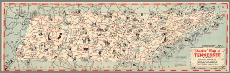
Author
[Dyer, Bill, Division of State Information, Department of Conservation]
Full Title
"Chuckle" map of Tennessee. By Bill Dyer. Produced and distributed by Division of State Information Department of Conservation, State Office Bldg. Nashville, Tenn. Copyright by the Tennessee Department of Highways and Public Work. (Cover title) Touring guide and "Chuckle" map: Tennessee, the nation's most interesting state.
List No
11079.003
Note
Pictorial map, 23.5x77, on sheet 47x77, folded into self wrapped cover 23x10. Date estimated based on the presence of The American Museum of Atomic Energy which opened in 1949. Shows roads, highways, rivers, major cities and towns. Numerous cartoon vignettes illustrating landmarks, agricultural products, recreational activities, animals, etc. Relief shown pictorially. On recto of cover: includes lists of parks, recreational and historic areas, Tennessee fishing lakes, Cities of Tennessee, and Mountains of Tennessee. On verso: Itineraries for 33 road trips.
Author
Gannett, Henry, 1846-1914
Full Title
Sketch map showing the position of the center of the Negro population and the median point in 1880, 1890 and 1900. Compiled by Henry Gannett, Geographer. (United States Census Office, 1903). Julius Bien & Co., N.Y.
List No
2152.052
Note
Lithographed map. Covers parts of Alabama, Georgia and Tennessee. Also shows counties, cities, railroads, etc.
Author
Lewis, Samuel
Full Title
Tennessee. Drawn by S. Lewis. Engraved by Lawson. (Boston: Published by Thomas & Andrews. 1812)
List No
0028.047
Note
Engraved map, uncolored. Relief shown by hachures. Shows counties, "Indian lines," settlements, rivers, etc. Prime meridians: Philadelphia and London. The names of Lewis and Lawson partially erased.
Author
Rand McNally and Company
Full Title
Rand McNally Junior Auto Road Map of Kentucky, Tennessee. Copyright by Rand McNally & Company. Chicago, Ill. Made in U.S.A. P.1052.
List No
4245.008
Note
Color map. Includes explanation, and alphabetical index of cities and towns, giving populations and Key to map. U.S. interstate highways shown in red. Shows Highway markers.
Author
Lewis, Samuel
Full Title
Tennessee. Drawn by S. Lewis. Engraved by Lawson. (Published by John Conrad & Co., Philadelphia. 1804)
List No
2436.052
Note
Engraved map, uncolored. Relief shown by hachures. Shows counties, "Indian lines," settlements, rivers, etc. Prime meridians: Philadelphia and London.
Author
Stein, Christ. Gottfr. Dan.
Full Title
Vereinigte Staaten von NordAmer(ika, nebst Mexico und Centralamerika. Westliche Theil). (with) San Francisco und Umgegend. (with) Die deutsche Colonie Wartburg, Staat Tennessee. (with) Die nordostlichen Staaten der Union. (with) Eisenbahnverbindung zwischen Chagres und Panama. (with) Isthmus von Panama. (with New York Bay). Entworfen von G. Heck, gestochen under s. Leitung. (Gestochen von R. Schmidt, H. Eberhardt u. J.L. v. Baehr). J.C. Hinrichs'sche Buchhandlung, Leipzig. (1865)
List No
3134.023
Note
Hand colored map. Relief shown by hachures. Shows populated places, Indian villages and missions, ports, railroads, canals, roads, etc. Prime meridians: Ferro and Greenwich. ("Stein, Neuer Atlas der ganzen Erde")
Author
Stein, Christ. Gottfr. Dan.
Full Title
(Composite of) Vereinigte Staaten von NordAmerika, nebst Mexico und Centralamerika. (with) San Francisco und Umgegend. (with) Die deutsche Colonie Wartburg, Staat Tennessee. (with) Die nordostlichen Staaten der Union. (with) Eisenbahnverbindung zwischen Chagres und Panama. (with) Isthmus von Panama. (with New York Bay). (with) Plan von Boston. Entworfen von G. Heck, gestochen under s. Leitung. Gestochen von R. Schmidt, H. Eberhardt u. J.L. v. Baehr. J.C. Hinrichs'sche Buchhandlung, Leipzig. (1865)
List No
3134.025
Note
Digital composite of 2 hand colored maps. Relief shown by hachures. Shows populated places, Indian villages and missions, ports, railroads, canals, roads, etc. Prime meridians: Ferro and Greenwich. "Stein, Neuer Atlas der ganzen Erde."
Author
[Kellogg, Sanford Cobb, 1842-, Mergell, C. S., United States. Army. Corps of Engineers]
Full Title
The Middle-Tennessee Campaign of June and July 1863, enlarged from a map compiled in 1865, by C.S. Mergell, under the direction of Col. W.E. Merrill, 1st U.S. V.V. Eng'rs, and published by the Chief of Engineers of the Army in 1874. Drawn by J. von Glumer. Positions of troops located in 1891 by Captain S.C. Kellogg, 5th Cavalry. Julius Bien & Co. lith. (Washington, D.C.: U.S. Government Printing Office, 1891)
List No
4249.001
Note
Col. lithographed map. Relief shown by hachures and spot heights. Includes lengthy note "Legend." Shows actions June 23-28.
Author
[Kellogg, Sanford Cobb, 1842-, Mergell, C. S., United States. Army. Corps of Engineers]
Full Title
The Middle-Tennessee Campaign of June and July 1863, enlarged from a map compiled in 1865, by C.S. Mergell, under the direction of Col. W.E. Merrill, 1st U.S. V.V. Eng'rs, and published by the Chief of Engineers of the Army in 1874. Drawn by J. von Glumer. Positions of troops located in 1891 by Captain S.C. Kellogg, 5th Cavalry. Julius Bien & Co. lith. (Washington, D.C.: U.S. Government Printing Office, 1891)
List No
4249.002
Note
Col. lithographed map. Relief shown by hachures and spot heights. Includes lengthy note "Legend." Shows actions June 28-July 7th.
Author
[Kellogg, Sanford Cobb, 1842-, Mergell, C. S., United States. Army. Corps of Engineers]
Full Title
The Middle-Tennessee Campaign of June and July 1863, enlarged from a map compiled in 1865, by C.S. Mergell, under the direction of Col. W.E. Merrill, 1st U.S. V.V. Eng'rs, and published by the Chief of Engineers of the Army in 1874. Drawn by J. von Glumer. Positions of troops located in 1891 by Captain S.C. Kellogg, 5th Cavalry. Julius Bien & Co. lith. (Washington, D.C.: U.S. Government Printing Office, 1891)
List No
4249.003
Note
Col. lithographed map. Relief shown by hachures and spot heights. Includes lengthy note "Legend." Shows actions July 7-Aug. 19.
Author
[Kellogg, Sanford Cobb, 1842-, Mergell, C. S., United States. Army. Corps of Engineers]
Full Title
The Chattanooga Campaign of August and September 1863, enlarged from a map compiled in 1865, by C.S. Mergell, under the direction of Col. W.E. Merrill, 1st U.S. V.V. Eng'rs, and published by the Chief of Engineers of the Army in 1874. Drawn by J. von Glumer. Positions of troops located in 1891 by Captain S.C. Kellogg, 5th Cavalry. Julius Bien & Co. lith. (Washington, D.C.: U.S. Government Printing Office, 1891)
List No
4249.004
Note
Col. lithographed map. Relief shown by hachures and spot heights. Includes lengthy note "Legend." Shows actions July 15-Aug. 31.
Author
[Kellogg, Sanford Cobb, 1842-, Mergell, C. S., United States. Army. Corps of Engineers]
Full Title
The Chattanooga Campaign of August and September 1863, enlarged from a map compiled in 1865, by C.S. Mergell, under the direction of Col. W.E. Merrill, 1st U.S. V.V. Eng'rs, and published by the Chief of Engineers of the Army in 1874. Drawn by J. von Glumer. Positions of troops located in 1891 by Captain S.C. Kellogg, 5th Cavalry. Julius Bien & Co. lith. (Washington, D.C.: U.S. Government Printing Office, 1891)
List No
4249.005
Note
Col. lithographed map. Relief shown by hachures and spot heights. Includes lengthy note "Legend." Shows actions Aug. 29-Sept. 17.
Author
[Kellogg, Sanford Cobb, 1842-, Mergell, C. S., United States. Army. Corps of Engineers]
Full Title
The Chattanooga Campaign of August and September 1863, enlarged from a map compiled in 1865, by C.S. Mergell, under the direction of Col. W.E. Merrill, 1st U.S. V.V. Eng'rs, and published by the Chief of Engineers of the Army in 1874. Drawn by J. von Glumer. Positions of troops located in 1891 by Captain S.C. Kellogg, 5th Cavalry. Julius Bien & Co. lith. (Washington, D.C.: U.S. Government Printing Office, 1891)
List No
4249.006
Note
Col. lithographed map. Relief shown by hachures and spot heights. Includes lengthy note "Legend." Shows actions Sept. 9-19.
Author
[Kellogg, Sanford Cobb, 1842-, Mergell, C. S., United States. Army. Corps of Engineers]
Full Title
The Chattanooga Campaign of August and September 1863, enlarged from a map compiled in 1865, by C.S. Mergell, under the direction of Col. W.E. Merrill, 1st U.S. V.V. Eng'rs, and published by the Chief of Engineers of the Army in 1874. Drawn by J. von Glumer. Positions of troops located in 1891 by Captain S.C. Kellogg, 5th Cavalry. Movements and positions preceding Battle of Chickamauga, locations made by Captain S.C. Kellogg, 5th Cavalry, 1891. Julius Bien & Co. lith. (Washington, D.C.: U.S. Government Printing Office, 1891)
List No
4249.007
Note
Two col. lithographed maps on 1 sheet. Scale of "Movements and positions preceding Battle of Chickamauga ..." (ca. 1:82,000), covering W 85o 20'--W 85o05'/N 35o10'--N 34o40'). Relief shown by hachures and spot heights. Includes lengthy note "Legend." In margin: Errata * In last line of legend for westward read eastward. Shows actions July 10-Sept. 13.
Author
United States. Army. Corps of Engineers
Full Title
(Covers to) The Middle Tennessee and Chattanooga Campaigns of June, July, August and September 1863. (Chief of Engineers of the Army. Washington, D.C.: U.S. Government Printing Office, 1891)
List No
4249A
Note
All eight maps are derived and enlarged from an 1865 "Military Map of Middle Tennessee and parts of East Tennessee..." by C.S. Mergell (LC Civil War maps, 393) which was published in 1874. Each map says "Positions of the Troops located in 1891." Covers are half leather, red cloth covered boards with label reading "The Middle Tennessee and Chattanooga Campaign of 1863 including the Battle of Chickamauga." These maps are of great interest to historians of these battles because the level of detail regarding troop positions, etc. is very good. With printed color. Maps printed by Julius Bien & Co.
Author
United States. Army. Corps of Engineers
Full Title
(Title Page to) The Middle Tennessee and Chattanooga Campaigns of June, July, August and September 1863. (Chief of Engineers of the Army. Washington, D.C.: U.S. Government Printing Office, 1891)
List No
4249B
Note
All eight maps are derived and enlarged from an 1865 "Military Map of Middle Tennessee and parts of East Tennessee..." by C.S. Mergell (LC Civil War maps, 393) which was published in 1874. Each map says "Positions of the Troops located in 1891." Covers are half leather, red cloth covered boards with label reading "The Middle Tennessee and Chattanooga Campaign of 1863 including the Battle of Chickamauga." These maps are of great interest to historians of these battles because the level of detail regarding troop positions, etc. is very good. With printed color. Maps printed by Julius Bien & Co.
Author
Fullarton, A. & Co.
Full Title
United States North America According to Calvin, Smith & Tanner. By G.H. Swanston Edinr. The South Eastern States Comprising Mississippi, Alabama, Tennessee, Georgia, Nth. & Sth. Carolina, and part of Florida, Virginia & Kentucky. LVIII. Engd. by G.H. Swanston Edinburgh. A. Fullarton & Co. Edinburgh, London & Dublin.
List No
3007.059
Note
In full color by state.
Author
Johnson, A.J.
Full Title
Johnson's Kentucky and Tennessee. Published by Alvin J. Johnson & Co., New York. 60. 61. Entered according to the Act of Congress, in the year 1865, by A.J. Johnson in the Clerk's Office of the District Court of the United States for the Southern District of New York.
List No
4828.043
Note
Engraved color map with counties and districts differentiated by color. Shows roads and railroads. Major relief shown by hachures.
Full Title
Carte geographique, statistique et historique du Tennessee. Tennessee. Grave par E. Collin. Fonderie et Imprimerie de J. Carez. (1825)
List No
0102.028
Note
Hand colored engraved map. Relief shown by hachures. Text and tables at sides and bottom. Prime meridians: Washington and Paris.
Author
[Bates, Ernest Sutherland, 1879-1939, Schiff, Herman S., Reeves, Norman, Smith, Robert E.]
Full Title
Tennessee, 1796.
List No
14244.041
Note
Pictorial map of Tennessee, showing political boundaries with bordering states and major rivers. Features natural resources and manufactured items (including marbles, lumber, wheat and foundries). Includes a compass rose and a scroll listing notable places - such as Andrew Jackson's Hermitage - which are pictured in vignettes below map, in order of listing. Map is 17 x 29 cm, on sheet 23 x 29 cm. Accompanied by historical text on facing page.
Author
Petri, Girolamo
Full Title
Tav. CXXX. Provincia ecclesiastica di S. Luigi.
List No
14007.317
Note
Hand-colored, engraved map showing the ecclesiastical provinces of Saint Louis (Missouri), as well as the greater Midwestern United States. With 2 insets: (Tennessee) -- (Nuovo Messico). Text in delicate script circling land. Accompanied by descriptive text on facing page. In Volume III.
Author
Clason Map Company
Full Title
Clason's Road Map of Kentucky and Tennessee. Showing paved roads, All weather roads and other throughfares. (U.S. Highways shown in red.) Published by the Clason Map Co., Denver. Copyrighted Clason Map. All rights reserved. Map No. R-251A.
List No
4423.023
Note
Color map. Includes road legend, and Index of cities and towns giving 1930 Census populations and Key to map.
Author
Tanner, Henry S.
Full Title
Kentucky and Tennessee. By H.S. Tanner. 1827. American Atlas. Engraved and Published by H.S. Tanner, Philadelphia. Entered according to Act of Congress, 20th Day of August, 1823, by H.S. Tanner, of the State of Pennsylvania.
List No
4862.019
Note
Engraved. Counties differentiated by full color. Relief shown by hachures.
Author
[Bourquin, Frederick, Mitchell, Samuel Augustus, Tanner, Henry S.]
Full Title
A New Map of Tennessee with its Roads & Distances from place to place along Stage and Steam Boat Routes. By H.S. Tanner. Entered according to Act of Congress in the 1841 by H.S. Tanner - in the Clerk's Office of the Eastern District of Pennsylvania. 26.
List No
4578.027
Note
Lithographed. Canals, roads, railroads, and rivers shown. Table of distances. Meridian Washington. Insets of Nashville and Knoxville. Relief shown with hachures.
Author
Asher & Adams
Full Title
Asher & Adams' Kentucky & Tennessee. Entered according to Act of Congress 1874 by Asher & Adams in the Office of the Librarian of Congress at Washington.
List No
4977.026
Note
Washington Meridian. Hand tinted full color. Relief shown in hachures. Shows railroads, settlements, counties, waterways, and lakes. Engraved.
Author
Lucas, Fielding Jr.
Full Title
Tennessee. 26. H.S. Tanner, sc. (1816)
List No
4534.026
Note
Engraved, hand colored. Counties shown. Relief shown with hachures.. Meridian London.
Author
Greenleaf, Jeremiah
Full Title
Kentucky And Tennessee.
List No
2866.049
Note
Full color by county. Engraved. Relief shown by hachures. Meridians Greenwich and Washington.
Author
Johnson, A.J.
Full Title
Johnson's Kentucky and Tennessee. Published by A. J. Johnson, New York. 60. 61. Entered according to the Act of Congress, in the year 1865, by A.J. Johnson in the Clerk's Office of the District Court of the United States for the Southern District of New York.
List No
4574.029
Note
Engraved color map with counties and districts differentiated by color. Shows roads and railroads. Major relief shown by hachures.
Author
Lucas, Fielding Jr.
Full Title
Tennessee. Drawn and Published by F. Lucas Jr. B.T. Welch & Co., Sc. (1822)
List No
4866.050
Note
Engraved. Colored by county. Meridians London and Washington. Relief shown by hachures.
Author
Melish, John
Full Title
Map of the Country belonging to the Cherokee and Creek Indians From the Original Drawing in the War Department. J. Melish del. (1824)
List No
2803.020
Note
Engraved. Meridians Washington and London. Bound with sheet inverted. Shows routes taken by General Jackson's Army to the Creek Nation and by General Cock's Army.
Author
Colton, G.W.
Full Title
Kentucky and Tennessee. No. 38. Published by J.H. Colton & Co., No 172 William St., New York. Entered according to the Act of Congress in the year 1855 by J.H. Colton & Co. in the Clerk's Office of the District Court of the United States for the Southern District of New York.
List No
5479.077
Note
Meridians Washington and Greenwich. Counties tinted in color. Relief shown in hachures.
Author
Mitchell, Samuel Augustus
Full Title
A New Map of Tennessee with its Roads & Distances from place to place along Stage & Steam Boat Routes. Published By Charles Desilver, No. 714 Chestnut Street. Entered according to Act of Congress in the year 1856 by Charles Desilver in the Clerk's office if the District Court of the Eastern District of Pennsylvania. 27.
List No
4557.027
Note
Counties tinted in color. Meridian Washington. Relief shown with hachures. Table of Steamship Routes. Insets of Environs of Nashville and Environs of Knoxville.
Author
Rand McNally and Company
Full Title
Rand, McNally & Co.'s Kentucky and Tennessee.
List No
2844.038
Note
Relief shown by hachures. Railroads and chief cities listed and keyed to map.
Full Title
County map of Kentucky and Tennessee. Copyright 1886 by Wm. M. Bradley & Bro.
List No
5784.024
Note
Hand colored. Relief shown by hachures. Shows settlements, railroads, rivers, etc. Prime meridians: Greenwich and Washington.
Author
Rand McNally and Company
Full Title
Rand, McNally & Co.'s Kentucky and Tennessee.
List No
4520.029
Note
In outline color by county. Shows named railroads. Relief shown by hachures.
Author
Tanner, Henry S.
Full Title
A New Map Of Tennessee With Its Roads & Distances from place to place, along the Stage & Steam Boat Routes. by H.S. Tanner. Engraved by J. & W.W. Warr. Entered ... 1841 by H.S. Tanner ... Pennsylvania. Published by Carey & Hart Philadelphia. (above neat line) Tanner's Universal Atlas.
List No
5363.027
Note
In full color by county with steamboat route distances noted. Insets of Environs of Nashville and Environs of Knoxville. Engraved. Relief shown by hachures. Meridian Washington.
Author
Lange, Henry, 1821-1893.
Full Title
Kentucky und Tennessee. H. Lange's Atlas v. Nord Amerika Blatt VII. Braunschweig: Verlag v. George Westermann. Lith. Anst. von L. Kraatz in Berlin.
List No
2743.007
Note
Engraved map. Borders hand col. Shows roads, railroads, canals, etc. Relief shown by hachures.
Author
[Bartholomew, John, Black, Adam & Charles]
Full Title
Kentucky and Tennessee. Published by A. & C. Black. Edinburgh. Printed in Colours by Schenck & Macfariane. Edinburgh. Drawn & Engraved by J. Bartholomew, Edinburgh.
List No
0073.012
Note
States outlined in color. Land tinted.
Author
Mitchell, Samuel Augustus Jr.
Full Title
County map of Kentucky and Tennessee. Copyright by S. Augustus Mitchell 1884.
List No
0592.025
Note
Hand colored. Relief shown by hachures. Shows settlements, railroads, rivers, etc. Prime meridians: Greenwich and Washington.
Author
Rand McNally and Company
Full Title
(Text Page) Tennessee.
List No
2094BK
Note
List of geographical features indexed to map.
Author
Rand McNally and Company
Full Title
(Text Page) Tennessee.
List No
2094BL
Note
List of geographical features indexed to map.
|