|
Author
[Boyd, C. H., United States. War Department]
Full Title
Battle-field of Chickamauga, Ga. Surveyed by command of Maj. Gen. G.H. Thomas, commanding Dept. of the Cumberland, by Capt. C.H. Boyd, Sub-Asst., U.S.C.S., April and May, 1864. Assisted in levelling by Lieut. Kuntze and Sergeant Wilson, Top. Engineers, 2d Division, 14th Army Corps. (with) Map showing the army movements around Chattanooga, Tenn. made to accompany the report of Maj. Gen. U.S. Grant by direction of Brig. Gen. Wm. F. Smith ... Jan. 4th 1864, compiled and drawn by H. Riemann ... (with) Map of the battle-field of Cold Harbor, Va. From surveys under the direction of ... N. Michler ... and ... P.S. Michie ..., by command of ... A.A. Humphreys ... 1867. Surveyed and drawn by Maj. J.E. Weyss, assisted by F. Theilkuhl, J. Strasser and G. Thompson. Julius Bien & Co., Lith., N.Y. (1891-1895)
List No
1780.097
Note
Col. map with 2 ancillary maps. Relief shown by contours.
Author
[Poe, Orlando M., Ullfers, Herman. A., United States. War Department]
Full Title
Map illustrating the march of the army under command of Maj. Gen. W.T. Sherman from Atlanta, Georgia to Savannah, Georgia. November 15th to December 21st 1864. Prepared under the direction of Capt. O.M. Poe, Corps of Engrs., Chief Engineer, Mill. Div. Miss. Drawn by Capt. H.A. Ulffers, A.A.G. Vols. (with) Campaign maps showing position of the 20th Army Corps on the march from Chattanooga, Tenn. to Atlanta, Ga. With dates and Union and rebel defenses. From surveys by Capt. Samuel A. Bennett ... (with) Map showing battle-field of Peach Tree Creek, Ga. Fought July 20, 1864. (with) Map of that portion of the battle-field of Chickamauga where Gen. Thomas opened the battle. Sept. 19, 1863. Also map of country from Mission Mills to Alexander's Bridge by D. McCook. Julius Bien & Co., Lith., N.Y. (1891-1895)
List No
1780.101
Note
Col. map with 20 ancillary maps.
Author
[McAlester, Miles D., McGregory, Samuel E., United States. War Department]
Full Title
Rebel defenses, Mobile, Ala., occupied by Union forces under Maj. Gen. E.R.S. Canby April 12, 1865. Drawn by order of Maj. McAlester, Chief Engineer, Army and Division West Miss. under direction of Lieut. S.E. McGregory ... (with) Headquarters, Army of the Potomac, Engineer Dept., June 18th, 1864. This map exhibits the lines of the enemy in our possession up to date. N. Michler. (with) Sketch of affair at Rappahannock Station, Va., March 28th 1862. (with) Position of the 3d Division, 23d Army Corps at Columbia, Tenn., Nov. 24th-29th 1864. (with) Operations from New Berne, N.C. to Kinston, of Provisional Corps under command of Maj. Gen. J.D. Cox, U.S. Army, March 1-20, 1865. (with) Sketch of the battle-field of West Harpeth River, Tenn., December 17th 1864. Bvt. Maj. Gen. James H. Wilson, comdg. (with) E. no. 1. Sketch of the main line of the enemy's works in front of Petersburg, Va., upon the advance of the United States forces, June 1864. Official: N. Michler. (with) Map accompanying the report of Maj. Gen. J.D. Cox ... of operations of the 3d Division, 23d Army Corps and other forces under his command during the operations in front of Wilmington, N.C. in February 1865. (with) Sketch showing the disposition of the Cavalry Corps, Military Division of the Miss. ... James H. Wilson, commanding, at the battle of Franklin, Tenn., November 30, 1864. By F. Tunica, Engineer ... Julius Bien & Co., Lith., N.Y. (1891-1895)
List No
1780.105
Note
Col. map with 8 ancillary maps. Relief shown by hachures. Includes 15 small plans and sections of redans, forts and redoubts including Fort Jeb Stuart and Fort Sidney Johnston.
Author
[Hotchkiss, Jed., United States. War Department]
Full Title
Defenses of Chattanooga, Tenn. (with) Battle of Cross Keys, Va., June 8, 1862 by Jed. Hotchkiss ... Sketch showing positions of Second Corps, A.N.Va., August 26th to September 2, 1862 embracing engagements at Bristoe Station, Manassas Junction, Groveton or Second Bull Run and Ox Hill or Chantilly, Va. Prepared to accompany report of Lieut. Gen. Thos. J. Jackson by Jed. Hotchkiss ... Jan. 1863. Map of the battle-field of Chickamauga, Ga. and vicinity, fought September 18th, 19th and 20th 1863. Charles Foster, draughtsman. (with) Sketch showing position of Confederate and Federal armies at Franklin, Va., May 9th to 11th 1862 by Jed. Hotchkiss ... (with) Defenses of Cleveland, Tenn. (with) Defenses of Knoxville, Tenn. (with) Defenses of Loudon, Tenn. (with) Defenses of Charleston, Tenn. (with) Defenses of Chattanooga, Tenn. Plan of Fort Phelps. Reduced from a plan furnished by Col. W.E. Merrill ... April 18th 1865. (with) Defenses of Chattanooga, Tenn. Fort Creighton. (with) Defenses of Chattanooga, Tenn. Battery Bushnell. (with) Defenses of Chattanooga, Tenn. Lunette O'Meara. (with) Defenses of Chattanooga, Tenn. Redoubt Putnam. (with) Defenses of Chattanooga, Tenn. Fort Jones. Julius Bien & Co., Lith., N.Y. (1891-1895)
List No
1780.111
Note
Three col. maps with 12 ancillary maps and plans (5 col.). Relief shown by hachures or form lines. Some maps and plans accompany inspection report of Brig. Gen. Z.B. Tower.
Author
[Rziha, John, United States. War Department]
Full Title
Topographical sketch of Fortress Rosecrans near Murfreesborough, Tenn. Surveyed under the supervision of Brig. Gen. J. St. Clair Morton, U.S.A. by John Rziha, Capt. 19th U.S. Infty. Office Inst. Gen. of Fortifications, Mil. Div. Miss. ... April 1865, traced by W. Claypoole, del. (with) Map of Bridgeport, Ala. From a survey made under the direction of Col. W.E. Merrill ... (with) Map of Stevenson, Ala. From a survey made under the direction of Col. W.E. Merrill ... (with) Defenses of Nashville, Tenn. ... Traced from the original map in possession of Major James R. Willett ... W.E. Merrill. (with) Defenses of Chattanooga, Tenn. Fort Lytle. (with) Defenses of Chattanooga, Tenn. Fort Crutchfield. (with) Defenses of Chattanooga, Tenn. Fort Mihalotzy. (with) Defenses of Chattanooga, Tenn. Redoubt Carpenter. Julius Bien & Co., Lith., N.Y. (1891-1895)
List No
1780.112
Note
Col. map with 7 ancillary maps and plans (3 in col.). Relief shown by hachures. "Accompanying inspection report of Brig. Gen. Z.B. Tower ... 1865."
Author
United States. War Department
Full Title
Defenses of Chattanooga, Tenn. Battery Erwin ... Battery Coolidge. Defenses of Nashville, Tenn. Capitol, planned and executed by Brig. Gen. James St. Clair Morton, from a plan by Maj. Willett. Fort Dan McCook ... showing changes made by Brig. Gen. Z.B. Tower ... Battery for Casino Hill ... Fort Morton ... Fort Sill, plan of fort ... Fort W.D. Whipple ... Redoubt for Hill no. 210, not yet constructed, May, 1865 ... Julius Bien & Co., Lith., N.Y. (1891-1895)
List No
1780.113
Note
Nine b&w plans, some with sections.
Author
United States. War Department
Full Title
Fort Donelson, Tenn. Copied from the original plan prepared under the direction of Col. Wm. E. Merrill by Maj. James R. Willett ... From a survey by John H. Willett, Jan. 1865 ... Track of interior crest Fort Pickering, Memphis, Tenn. showing the interior works ... copied from a tracing ... by Maj. Gen. Gillmore. W. Claypoole, del. Z.B. Tower, Brig. Gen. and Insp. Gen. Fortifications, Mil. Div. Miss. Memphis and its environs ... 1865. (with) Defenses of Nashville, Tenn. Fort at Hyde's Ferry ... (with) ... Plan and section of redoubt on north side of Cumberland River 3/4 mile from the railroad bridge ... (with) ... Fort Harker. Planned and built by Brig. Gen. St. Clair Morton ... Julius Bien & Co., Lith., N.Y. (1891-1895)
List No
1780.114
Note
Three col. maps with 3 b&w plans (with sections). Relief shown by hachures or contours.
Author
United States. War Department
Full Title
Topographical map of Clarksville, Tenn. Copied from the original plan prepared under the direction of Col. W.E. Merrill ... by Maj. James R. Willett ... From a survey by John H. Willett, Dec., 1864 ... 1865. Traced by W. Claypoole. Dalton, Ga. Copied from the original plan by Maj. Willett from a survey by R.M. Radford ... (with) Topographical map of Johnsonville, Tenn ... 1865. (with) Franklin, Tenn .... survey by Charles Peseux ... (with) Topographical map of Columbia, Tenn and vicinity ... (with) Gallatin, Tenn ... (with) Decatur, Ala. ... (with) Topographical sketch of Athens, Ala ... (with) Huntsville, Ala ... Surveyed by Jno. Willett and Chas. Peseux ... Julius Bien & Co., Lith., N.Y. (1891-1895)
List No
1780.115
Note
Two col. maps with 7 ancillary maps. Relief shown by hachures or contours. "Accompanying inspection report of Brig. Gen. Z.B. Tower."
Author
[Ruger, Edward, United States. War Department]
Full Title
Map prepared to exhibit the campaigns in which the Army of the Cumberland took part during the War of the Rebellion. By order of Maj. Gen. Geo. H. Thomas, U.S.A. Compiled under the direction of Bvt. Maj. Gen. Z.B. Tower, Chief Engr., Milit. Div. of the Tenn., by Ed. Ruger ... Assistants: Capt. A. Kilp and Lieut. R. Flach ... (with) Map illustrating the operations of the Seventh Division under Brig. Gen. G.W. Morgan at Cumberland Gap, Tenn., during a portion of the year 1862. Compiled by Edward Ruger ... 1877 (with) Map of the environs of Petersburg, Va., from the Appomattox River to Ft. Howard, showing the positions of the entrenched lines occupied by the Ninth Army Corps, A.P. during the siege. Julius Bien & Co., Lith., N.Y. (1891-1895)
List No
1780.118
Note
Col. map with 2 ancillary maps. Relief shown by hachures.
Author
[Merrill, William E., United States. War Department]
Full Title
Chattanooga, Tenn. from Cameron Hill, taken April 1864. Made under the direction of Capt. W.E. Merrill, Chief Engr., D.C. (with) U.S. military bridge over the Tennessee at Chattanooga, taken March 1864 ... (with) Part of Missionary Ridge, Tenn. (with) Govt. wagon yard at Chattanooga, Tenn. showing Cameron Hill and Fort Carpenter. (with) Blockhouse for defense of R.R. yard at Chattanooga, Tenn. (with) The Suck--Tenn. River below Chattanooga, looking up the river. (with) The Suck--Tenn. River below Chattanooga, looking down the river. Julius Bien & Co., Lith., N.Y. (1891-1895)
List No
1780.123
Note
Sepia-toned lithograph with 7 ancillary views. Military bridge and Missionary Ridge illustrations "From original photograph on file in the Office of the Chief of Engineers, U.S. Army."
Author
United States. War Department
Full Title
Nashville, Tenn., from the south-east, showing the State Capitol. Accompanying letter of Col. W.E. Merrill ... (with) Fort on St. Cloud Hill, Nashville, Tenn. in course of construction, Oct. 15th '62. (with) Point of Lookout Mountain, Tenn. taken during high water, looking down the river. (with) Rossville Gap., Ga. (with) Buzzard Roost Gap and Rocky Face Ridge, Ga. (with) 100 pdr. gun battery, intrenchments at Dutch Gap, Va. (with) Canvass pontoon bridge, Appomattox River, Broadway, Va. (with) Battery Spofford, Va. (with) Signal station, Va. at Fort Wisconsin, left of line. Julius Bien & Co., Lith., N.Y. (1891-1895)
List No
1780.124
Note
Eleven sepia-toned lithographs. Three views have "Accompanying report of Lieut. P.S. Michie, U.S. Engrs." Signal station view has "Accompanying report of Big. Gen. G. Weitzel, U.S. Army."
Author
United States. War Department
Full Title
Position of iron clads, January 15th, 1865. Engine "Hero" destroyed partially by rebels when avacuating (sic) Atlanta, Ga. (with) Rebel lines, Atlanta, Ga. looking across Augusta R.R. to the southward. (with) Rebel line on Augusta R.R. ... looking south. (with) Rebel lines on west side of Atlanta, Ga. looking southward. (with) Rebel lines, Atlanta, Ga. (with) U.S. Rolling Mill at Chattanooga, Tenn. (with) Ruins of rolling mill and cars destroyed by rebels on evacuation of Atlanta, Ga. (with) Round-house, Chattanooga R.R. at Atlanta, Ga. (with) Potter House, Atlanta, Ga. showing effects of bombardment. Julius Bien & Co., Lith., N.Y. (1891-1895)
List No
1780.129
Note
Ten sepia-toned lithographs. Some accompany report of Capt. O.M. Poe. U.S. Rolling Mill from original photograph in Office of the Chief of Engineers, U.S. Army. Iron clads from original in archives of the U.S. Coast Survey. Ships shown: Minnesota, Wabash, Mahopac, Canonicus, Iron Sides, Monadnock, Saugus, Malvern and Brooklyn.
Author
United States. War Department
Full Title
Panoramic view of Knoxville, Tenn. from cupola of University of East Tennessee, March 18th 1864. Knoxville, Tenn. from Fort Stanley, March 19, 1864. Panoramic view of Knoxville, Tenn. from cupola of University of East Tennessee. March 18th 1864. Chattanooga, Tennessee, 1864. Knoxville, Tenn. from Mabry's Hill. Chattanooga, Tennessee 1864. Julius Bien & Co., Lith., N.Y. (1891-1895)
List No
1780.130
Note
Six sepia-toned lithographs. Knoxville views accompany report of Capt. O.M. Poe. Chattanooga views from original photographs in Office of the Chief of Engineers, U.S. Army.
Author
[Twining, William J., United States. War Department]
Full Title
Map of Fort Anderson, N.C. Captured February 19th 1865 by the Army of the Ohio. Maj. Gen. J.M. Schofield, Comd'g. Official Wm. J. Twining, Capt. and Ch'f. Engr. (with) Map of Franklin, Tenn. Including field works and positions of troops 4th and 23rd Corps, during the engagement of November 30th 1864. Maj. Gen. Schofield, Comd'g. ... (with) Map of the battle-field of Droop Mountain drawn from a partial survey by Henry Topping. 6th Nov. 1863. (with) Battle-ground near White Sulphur Springs. August 26 and 27, 1863. Drawn by Lieut. J.R. Meigs, U.S. Engrs. (with Savannah and Wright rivers, S.C., Feb. 6, 1862). Accompanying report of Maj. O.T. Beard ... Julius Bien & Co., Lith., N.Y. (1891-1895)
List No
1780.137
Note
Col. map with 5 ancillary maps. Relief shown by hachures.
Author
[Meigs, John R., United States. War Department]
Full Title
Map of a part of Virginia exhibiting the routes of Genl. W.W. Averell, in his three expeditions of August, November & December, 1863. Drawn under the direction of Lieut. J.R. Meigs, Corps of Engineers, Chief Engr. Dept. W. Va. (with) Map of the New Creek Sta., B.& O.R.R. Drawn by John R. Meigs ... Aug. 1863. (with) Map of Tete de Pont and battle of Big Black Bridge, May 17th, 1863. Saml. H. Lockett ... (with) Map of the battle-field of Baker's Creek, May 16th 1863. Saml. H. Lockett. Wm. L. Sheppard, draughtsman. Field works at Franklin, Tenn. Occupied by the 23rd and 4th Corps during engagements of Nov. 30th 1864. Maj. Gen. J.M. Schofield, com'd'g. Official: Wm. J. Twining ... Julius Bien & Co., Lith., N.Y. (1891-1895)
List No
1780.138
Note
Col. map with 4 ancillary maps. Relief shown by hachures.
Author
Swann, Charles E.
Full Title
(Covers to) Military Map of the States of Kentucky and Tennessee, within eleven miles of the 35th Parallel of Latitude or Southern Boundary of Tennessee; Compiled from the best authentic original maps, various documents, and miscellaneous latest sources of information. Commenced under the Authority of Major General Don Carlos Buell ... by Capt. N. Michler ... continued under Major General H.G. Wright by Maj. L. Sitgreaves ... and completed under Major General Ambrose E. Burnside ... by Lieut. Col. J.H. Simpson ... Drawn by Charles E. Swann, Asst. Engr. ... Office of Chief Engineer, Department of the Ohio. Cincinnati, Ohio, November, 1863. Ehrgott, Forbriger & Co. Lithographers, Engravers & Printers, Corner 4th & Walnut Streets, Cincinnati, O.
List No
5384A
Author
Swann, Charles E.
Full Title
Military Map of the States of Kentucky and Tennessee, within eleven miles of the 35th Parallel of Latitude or Southern Boundary of Tennessee; Compiled from the best authentic original maps, various documents, and miscellaneous latest sources of information. Commenced under the Authority of Major General Don Carlos Buell ... by Capt. N. Michler ... continued under Major General H.G. Wright by Maj. L. Sitgreaves ... and completed under Major General Ambrose E. Burnside ... by Lieut. Col. J.H. Simpson ... Drawn by Charles E. Swann, Asst. Engr. ... Office of Chief Engineer, Department of the Ohio. Cincinnati, Ohio, November, 1863. Ehrgott, Forbriger & Co. Lithographers, Engravers & Printers, Corner 4th & Walnut Streets, Cincinnati, O.
List No
5384.001
Note
Outline color by state; with "Improved Turnpike & Stage Roads" in red. Maps is mounted on linen and dissected into 48 sections with dark brown cloth end sheets (19x34) with a paper label printed with "Military Map Of Kentucky And Tennessee. Official: J.H. Simpson, Lieut. Col. Engr. U.S. Army, Chief Engr. Dpt. of the Ohio" in gold. A second issue shows Camp Burnside named, the lithographer's name revised, and a dotted line representing the "out line of coal field" has been added to the southeastern quadrant.
Author
Matz, Otto H.
Full Title
Map Of The Field Of Shiloh, Near Pittsburgh Landing, Tenn. Shewing The Position of the U.S. Forces under the Command Of Maj. Genl. U.S. Grant U.S. Vol. And Maj. Genl. D.C. Buell U.S. Vol. On The 6th And 7th of April 1862. Surveyed Under The Direction Of Col. Geo Thom. Chief of Topl. Engrs. Drawn by Otto H. Matz, Asst. Topl. Engr. Lith. by Chas. Robyn & Co. cor. Chestnut and 3d St, St. Louis Mo.
List No
3863.002
Author
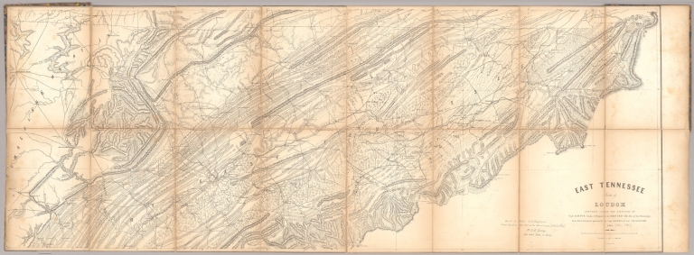
Poe, Orlando M.
Full Title
East Tennessee North of Loudon Prepared Under The Direction Of Capt. O.M. Poe Corps of Engineers & Chief Engr. Mil. Div. of the Mississippi, From Data furnished principally by Capt. O.M. Poe & Prof. J.M. Safford. 1864. S. Geismar Lith. Issued at Office U.S. Engineers, Head Quarters Mil. Divn. of the Mississippi. W.L.B. Jenney. Capt. A.D.C. U.S.A. In Charge.
List No
5534.002
|