|
REFINE
Browse All : Images of South America from 1948
1-10 of 10
Author
Pan American World Airways
Full Title
(PAA Route Map). Belem (to) Rio de Janeiro.
List No
12365.007
Note
Date estimated.
Author
Pan American World Airways
Full Title
(PAA Route Map). Rio de Janeiro (to) Buenos Aires.
List No
12365.008
Note
Date estimated.
Author
Pan American World Airways
Full Title
Linking the Central Americas.
List No
12419.005
Note
Date estimated.
Author
[Portugal. Ministério das Colónias, Portugal. Junta de Investigações Coloniais]
Full Title
Explorações Portugueses do continente sul Americao, no século XVI. Gravada e impressa no Instituto Geographico e Cadastral, em 1948. Ministério das Colónias, Junta das Missões Geográficas e de Investigações Coloniais.
List No
14369.017
Note
Map of South America, featuring Portuguese exploration in the sixteenth century. Also shows cities, bodies of water, drainage, coastlines and islands. Includes latitudinal and longitudinal lines, as well as a legend and explanatory notes. Map indexed to indicate areas explored during different voyages. Colored lithograph. Map is 38 x 26 cm, on sheet 48 x 34 cm.
Author
[Portugal. Ministério das Colónias, Portugal. Junta de Investigações Coloniais]
Full Title
Explorações Portugueses do continente sul Americao, no século XVII. Gravada e impressa no Instituto Geographico e Cadastral, em 1948. Ministério das Colónias, Junta das Missões Geográficas e de Investigações Coloniais.
List No
14369.018
Note
Map of South America, featuring Portuguese exploration in the seventeenth century. Also shows cities, bodies of water, drainage, coastlines and islands. Includes latitudinal and longitudinal lines, as well as a legend and explanatory notes. Map indexed to indicate areas explored during different voyages. Colored lithograph. Map is 38 x 26 cm, on sheet 48 x 34 cm.
Author
Thompson, Kenneth W.
Full Title
The Americas Served by American Republic Lines ; Grace Line ; Pan American Airways System Pan American-Grace Airways ; United Fruit Company. (by) Kenneth W. Thompson. Printed in U.S.A.
List No
6741.000
Note
Promotional pictorial map, advertising Grace Lines, Pan-American Airlines, Republic Air Systems and the United Fruit Company, by the aviation illustrator Kenneth Thompson. Includes decorative pictographs indicating tourist attractions and industries. The left and right borders depict the flags of the countries, on the upper and lower borders show symbol of the airline and cruise companies, and airplains and cruise ships.The text at the right provides a fantastic testimonial / public relations statement supporting the importance and seriousness of the expansion of commerce into Central America and South America. Color pictorial map. showing countries, major cities, rivers, etc. Relief shown by shadings.
Author
[Henrion, Frederic Henri Kay 1914 -1990, British South American Airways Corporation.]
Full Title
BSAA a la Europa par Aero Britanica. (by) Henrion. PS. 14/H.5/10/48/ J&S.
List No
11441.000
Note
Color BSAA Airline Travel Poster by Frederic Henri Kay Henrion. dated 5.10.48, for British South American Airways. Shows the service route from United Kingdom to South America. Henrion, a German graphic designer, specialized in commercial work, like this 1948 poster for the British South American Airways. During the WW II he worked for Ministry of Information, after the war became art director at Contact Books. His clients included British European Airways, KLM, the National Theatre, and the Post Office. Henrion's archive and library are located at University of Brighton Design Archives.
Author
Hammond, C.S.
Full Title
Resource-Relief Map of North America. 1415. Resource-Relief Map of South America. 3415. Resource-Relief Map of Africa. 2415. Resource-Relief Map of Asia. 5415.
List No
1954.007
Note
Set of four black and white maps titled separately.
Author
Hammond, C.S.
Full Title
South America. 5399. (inset) Valparaiso (vicinity). (inset) Buenos Aires. (inset) Rio de Janeiro. (inset) Galapagos.
List No
1954.050
Author
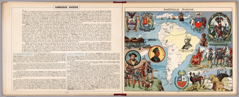
[Pinchon, J.P., Perpillou, A.]
Full Title
(Text Page with Map) Amerique Andine.
List No
7966.021
Note
Text and corresponding map with lavish vignettes of historic events, activities, crops, modes of transportation, structures, etc.
1-10 of 10
|