|
REFINE
Browse All : Images of South America and Chile and Brazil
1-12 of 12
Author
[Wytfliet, Corneille, Magini, Giovanni Antonio]
Full Title
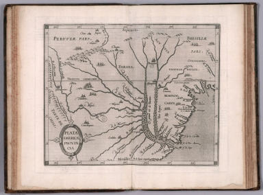
Plata Americae provincia. (to accompany) Histoire universelle des Indes occidentales et orientales, et de la conversion des Indiens : divisee en trois parties par Cornille Wytfliet & Anthoine Magin & autres historiens. Premiere Partie. A Douay, Chez Francois Fabri, l'An 1611.
List No
11622.020
Note
Uncolored engraved double page map of the Rio de la Plata region. Covers Argentina, Uruguay and the southern part of Brazil. Shows cities, towns, landmarks, rivers, capes, bays and mountains. Relief shown pictorially. Includes decorative title cartouche.
Author
Mitchell, Samuel Augustus
Full Title
Map of Brazil, Bolivia, Paraguay, and Uruguay. (with) Map of Chili. (with) Harbor of Bahia. (with) Harbor of Rio Janeiro. (with) Island of Juan Fernandez. Entered ... 1879 by S. Augustus Mitchell ... Washington. (1880)
List No
0586.056
Note
Hand colored map with 4 insets. Relief shown by hachures. Shows states and departments, settlements, railroads, etc. Prime meridians: Greenwich and Washington.
Author
Mitchell, Samuel Augustus Jr.
Full Title
Map of Brazil, Bolivia, Paraguay, and Uruguay. (with) Map of Chili. (with) Harbor of Bahia. (with) Harbor of Rio Janeiro. (with) Island of Juan Fernandez. Copyright 1886 by Wm. M. Bradley & Bro.
List No
0592.057
Note
Hand colored map with 4 insets. Relief shown by hachures. Shows states and departments, settlements, railroads, etc. Prime meridians: Greenwich and Washington.
Full Title
Map of Brazil, Bolivia, Paraguay, and Uruguay. (with) Map of Chili. (with) Harbor of Bahia. (with) Harbor of Rio Janeiro. (with) Island of Juan Fernandez. Copyright 1887 by Wm. M. Bradley & Bro. (1890)
List No
0594.055
Note
Hand colored map with 4 insets. Relief shown by hachures. Shows states and departments, settlements, railroads, etc. Prime meridians: Greenwich and Washington.
Full Title
South America. (with) Rio de Janeiro and Espirito Santo. (with) South-east Brazil and Uruguay. (with) Chile. (Published at the office of "The Times," London, 1895)
List No
1010.066
Note
Color maps with inset. Relief shown by hachures and spot heights. Shows settlements, railroads, etc. Scale of insets: 1:9,500,000-1:10,000,000.
Author
Meyer, Joseph, 1796-1856
Full Title
Sudlichster Theil von America enthaltend Bolivia, das sudliche Brasilien, Paraguay, Chile, La Plata, Cisplatina und Patagonien. 1850. Stich, Druck u. Verlag der geographischen Anstalt des Bibliographischen Instituts in Hildburghausen. (in upper margin) Meyer's Zeitung Atlas. No.81. (to accompany) Neuester Zeitungs-Atlas fur Alte und Neue Erdkunde. Herausgegeben von J. Meyer. (insets) Patagonien. (with) Falklands I.
List No
11652.103
Note
Engraved outline hand color map. Shows boundaries, cities and towns. Includes explanation and list of provinces. Prime meridian is Ferro. Relief shown by hachures.
Author
[Santini, Paolo, d'Anville]
Full Title
52. Carte qui Represente la Partie Meridionale du Bresil et du Perou, le Chili Septentrional, et le Paraguay ... de l'Amerique Meridionale.
List No
12039.135
Author
[Brion de La Tour, Louis, 1743 – 1803, Desnos, Louis Charles]
Full Title
Chili, Paraguay, Bresil, Amazones et Perou. Par M. Brion. A Paris, chez le Sr. Desnos. A.P.D.R. 1786. (to accompany) Atlas general, civil, ecclesiastique et militaire, methodique et elementaire pour l'etude de la geographie et de l'histoire ... par M. Brion, dirige par le sr. Desnos … A Paris 1786.
List No
13129.055
Note
Engraved hand color map of South America. Includes decorative engraved title cartouche and border. Shows political boundaries. Relief shown pictorially. Includes legend.
Author
Mitchell, Samuel Augustus
Full Title
Map of Brazil, Bolivia, Paraguay, and Uruguay. (with) Map of Chili. (with) Harbor of Bahia. (with) Harbor of Rio Janeiro. (with) Island of Juan Fernandez. Entered ... 1870 by S. Augustus Mitchell, Jr. ... Pennsylvania.
List No
2483.045
Note
Hand colored map with 4 insets. Relief shown by hachures. Shows states and departments, settlements, railroads, etc. Prime meridians: Greenwich and Washington.
Author
Meyer, Joseph, 1796-1856
Full Title
Sudlichster Theil von America enthaltend Bolivia, das sudliche Brasilien, Paraguay, Chile, La Plata, Cisplatina und Patagonien. 1834. Stich, Druck und verlag der geographischen Anstalt des Bibliographischen Instituts ... (In upper margin) Meyer's Atlas in 64 Karte. No. 46. (to accompany: Meyer's Zeitungs und Groschen Atlas aller Lander und Staaten der Erde). (insets) Patagonien. (with) Falklands I.
List No
4808.074
Note
Engraved outline hand color map. Shows boundaries, towns and place names. Relief shown by hachures. Includes explanation and list of provinces. Prime meridian is Ferro.
Full Title
Map of Brazil, Bolivia, Paraguay, and Uruguay. (with) Map of Chili. (with) Harbor of Bahia. (with) Harbor of Rio Janeiro. (with) Island of Juan Fernandez. Copyright 1886 by Wm. M. Bradley & Bro.
List No
5784.053
Note
Hand colored map with 4 insets. Relief shown by hachures. Shows states and departments, settlements, railroads, etc. Prime meridians: Greenwich and Washington.
Author
Debes, Ernst, 1840-1923
Full Title
Mittleres Sud-Amerika. Sept.1898. Bearbeitet von Dr. P. Elfert. Lithogr. von R. Friese, Irmgedruth & Riege. Verlag der Georg. Anstalt von Wagner & Debes, Leipzig. (to accompany) Neuer Handatlas uber alle Teile der Erde.1899. 59. (insets) I. Galapagos-Inseln. (and) II. Sud Chile.
List No
8002.110
Note
Outline color map on 2 sheets. Relief shown by hachures and spot heights. Depth shown by gradient tints and soundings. Prime meridian is Greenwich. Shows province, capitals, cities, railroads, telegraph cables, etc. Includes legend, notes, abbreviations, and inset of Konigreich Sachsen.
1-12 of 12
|