|
Author
[Nicholson, W. L., United States. Post Office Department]
Full Title
(Lower Part) Post route map of the Territory of Dakota with adjacent parts of Montana, Wyoming, Nebraska, Iowa and Minnesota and portions of the Dominion of Canada Designed and Constructed Under The Orders Of Postmaster General David M. Key by W.L. Nicholson Topographer of P.O. Dept. 1879.
List No
15661.002
Note
1st edition 1879, updated in ms to Jan. 1, 1880. Outline color.
Author
[Nicholson, W. L., United States. Post Office Department]
Full Title
(Upper Part) Post route map of the Territory of Dakota with adjacent parts of Montana, Wyoming, Nebraska, Iowa and Minnesota and portions of the Dominion of Canada Designed and Constructed Under The Orders Of Postmaster General David M. Key by W.L. Nicholson Topographer of P.O. Dept. 1879.
List No
15661.003
Note
1st edition 1879, updated in ms to Jan. 1, 1880. Outline color.
Author
[Nicholson, W. L., United States. Post Office Department]
Full Title
(Composite map to) (Upper and Lower Parts) Post route map of the Territory of Dakota with adjacent parts of Montana, Wyoming, Nebraska, Iowa and Minnesota and portions of the Dominion of Canada Designed and Constructed Under The Orders Of Postmaster General David M. Key by W.L. Nicholson Topographer of P.O. Dept. 1879.
List No
15661.004
Note
1st edition 1879, updated in ms to Jan. 1, 1880. Outline color.
Author
[Fisher, Joseph R., Planters Peanuts (Firm)]
Full Title
Tennessee : The volunteer state -- Kentucky : The blue grass state -- North Dakota : The Sioux state -- South Dakota : The coyote state.
List No
14374.013
Note
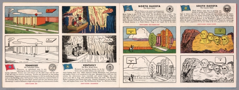
Four views, representing Tennessee, Kentucky, North Dakota and South Dakota. Views show examples of the landscape and natural resources. Each view includes an inset map of the state, which marks the location of the capital city with a star. Accompanied by descriptive text, the state flags, seals and flowers: iris, goldenrod, wild prairie rose and pasque flower, respectively. The view of each state appears both in color (on top) and in black and white (bottom), the latter inviting coloration. Together, views are 18 x 52 cm, on two sheets 20 x 54 cm.
Author
Cram, George Franklin, 1841-1928
Full Title
Railroad and county map of Dakota & Manitoba. Geo. F. Cram, engraver and publisher, Chicago.
List No
14250.036
Note
Map of the Dakotas and Manitoba (Canada), showing railroads (both finished and unfinished), county boundaries, cities and towns, post offices and drainage. Political boundary lines in color. Includes a legend. With index numbers along the perimeter, and decorative border. Also, with hand-drawn annotations tracing routes of travel across landscapes where no official transit appears. 55 x 40 cm, on sheet 58 x 45 cm.
Author
Burks, William III
Full Title
Map Of The Territory Of Crazy Horse And The Thunder Cult Society 1841 - 1877. Wm. Burks III. 1984.
List No
13368.001
Author
Dier, Frank
Full Title
A Cow pokes map of black Hills and his round up. Belle Fourche S. Dak. Annual Black Hills round up, July 3.4.5. Drawn by Frank Dier. (Copyright) 1937 Lee Printing Co. Rapid City, S.D. (inset views) Black Hills Clay Products Co. (with) American Colloid Bentonite Factory. (with) Beet Sugar Factory.
List No
11226.000
Note
Colored pictorial map of western South Dakota with decorative border of cow brand symbols. Showing in caricature format the various roads throughout, leading to Belle Fourche. Map depicting the Rodeo, Fair Grounds, people in various activities, animals, rivers, mountains and a man shown as a compass on lower right.
Author
Rand McNally & Co.
Full Title
Rand McNally & Co.'s sectional map of the Dakota and the Black Hills. Printed expressly for J. Bride & Co.'s Great American 25 Cent package, 767 and 769 Broadway, New York City. A.W. Barber, Del. Rand McNally & Co. Printers, engravers and electrotypers, 79 Madison Street, Chicago. (with 8 insets). (on verso) Rand McNally & Co.'s new railway guide map.
List No
6878.001
Note
This is one of the earliest Rand McNally maps that we have seen. The date of 1873 is determined from the only date on the map, in the inset map of Cincinnati. Uncolored sectional map with 8 insets: New mining map of Utah, St. Louis, Railroads around Baltimore and Washington, Philadelphia, New York and vicinity, Chicago, Railroad around Cincinnati, 1872-3, Denver. Showing boundaries of township, counties, states and territories, and detail diagram of township numbering system. Includes references, illustrations and advertisements. Relief shown by hachures. Prime meridian is Greenwich.
Author
[Geographical and Geological Survey of the Rocky Mountain Region (U.S.), Jenney, Walter Proctor, 1849-1921, Newton, Henry, 1845-1877]
Full Title
(covers to) Topographical and Geological Atlas of the Black Hills of Dakota to accompany the report of Henry Newton, E.M., assistant geologist. Department of the Interior, United States Geographical and Geological Survey of the Rocky Mountain Region, J.W. Powell, in charge. Julius Bien, Lith. New York, 1879.
List No
2083A
Note
Contains 2 maps, 1 view. David Rumsey copy is half redish leather, with brown cloth. Stamped in gold on cover, "Topographical and geological atlas of the Black Hills of Dakota. Powell. R.H. Rollins." E.H. Rollins copy (see DAB).
Author
[Geographical and Geological Survey of the Rocky Mountain Region (U.S.), Jenney, Walter Proctor, 1849-1921, Newton, Henry, 1845-1877]
Full Title
(Title Page to) Topographical and Geological Atlas of the Black Hills of Dakota to accompany the report of Henry Newton, E.M., assistant geologist. Department of the Interior, United States Geographical and Geological Survey of the Rocky Mountain Region, J.W. Powell, in charge. Julius Bien, Lith. New York, 1879.
List No
2083B
Note
Contains 2 maps, 1 view. David Rumsey copy is half redish leather, with brown cloth. Stamped in gold on cover, "Topographical and geological atlas of the Black Hills of Dakota. Powell. R.H. Rollins." E.H. Rollins copy (see DAB).
Author
[Geographical and Geological Survey of the Rocky Mountain Region (U.S.), Jenney, Walter Proctor, 1849-1921, Newton, Henry, 1845-1877]
Full Title
Bird's eye view of the Black Hills to illustrate the geological structure. Dept. of the Interior, U.S.G. and G. Survey, J.W. Powell, in charge. Geology of the Black Hills by Henry Newton, E.M. (Julius Bien, Lith. New York, 1879)
List No
2083.001
Author
[Geographical and Geological Survey of the Rocky Mountain Region (U.S.), Jenney, Walter Proctor, 1849-1921, M'Gillycuddy, V. T., Mahlo, Emil, 1851-1904, Newton, Henry, 1845-1877, Tuttle, H. P.]
Full Title
Map of the Black Hills of Dakota, from explorations made in 1873. W.P. Jenney, Engineer of Mines, in charge. H. Newton, Engineer of Mines, geologist. V.T. M'Gillycuddy, M.D., topographer. H.P. Tuttle, A.M., astronomer. Drawn by Emil Mahlo. Dept. of the Interior, U.S.G. and G. Survey, J.W. Powell, in charge. Geology of the Black Hills by Henry Newton, E.M. (Julius Bien, Lith. New York, 1879)
List No
2083.002
Note
Color lithograph map. Relief shown by hachures. Includes 3-line note on Sioux Reservation.
Author
[Geographical and Geological Survey of the Rocky Mountain Region (U.S.), Newton, Henry, 1845-1877]
Full Title
Geological map of the Black Hills of Dakota by Henry Newton, E.M. Dept. of the Interior, U.S.G. and G. Survey, J.W. Powell, in charge. Geology of the Black Hills by Henry Newton, E.M. (Julius Bien, Lith. New York, 1879)
List No
2083.003
Note
Color lithograph map. Relief shown by contours, hachures and spot heights.
Author
[Allen, Paul, Biddle, Nicholas, Clark, William, Lewis, Meriwether]
Full Title
Fortification.
List No
3493.002
Note
Uncolored map showing remains of a fortification on the Missouri River.
Author
Appleton, D. & Co.
Full Title
Map of South Dakota and North Dakota. Copyright 1891 by Matthews-Northrup Co. ... Buffalo, New York. (to accompany) The Library Atlas Of Modern Geography ... New York, D. Appleton And Company 1892. (on upper margin) South Dakota and North Dakota 97
List No
0026.244
Note
Color map. Shows state and county boundaries and county seat, capital, railways, roads, rivers, etc. "Size of type indicates importance of the places". Includes notes. Prime meridians are Greenwich and Washington. Relief shown by hachures.
Author
Arbuckle Bros.
Full Title
Indian Territory, New Mexico, South Dakota, Texas. Copyright 1889 Arbuckle Bros. N.Y.
List No
0027.005
Note
Sheet with maps of four states in full color. "Indian Territory" is now known as Oklahoma. It is noted that, "Of the 41,000,000 acres in the Territory, nearly 26,000,000 have been surveyed and set apart as reservations for the Indians. These have been gathered from all parts of the country, from Oregon to Florida, in pursuance of the general plan of congregating all the Indians in one territory, to be theirs forever." Each card measures 7.5 x 12.5 cm.
Author
Asher & Adams
Full Title
Asher & Adams' Dakota. Entered according to Act of Congress in the year 1874 by Asher & Adams ... at Washington. (New York, 1874)
List No
0041.034
Note
Hand col. engraved map. Shows townships, etc. Prime meridians: Greenwich and Washington.
Author
Colton, G.W.
Full Title
Minnesota. Published By J.H. Colton & Co. No. 172 William St. New York. Entered ... 1855 by J.H. Colton & Co. ... New York. No. 49.
List No
0149.054
Note
In full color. Minnesota extends from Lake Superior to the Missouri River (the middle of the present day Dakotas). Proposed route of the Pacific Railroad shown.
Author
Colton, G.W.
Full Title
Colton's Map of Kansas, Nebraska, Dakota & Indian Territory. Published By J. H. Colton. No. 172 William St. New York.
List No
0151.058
Note
Map showing the boundaries in color. Prime meridians are Greenwich and Washington D.C.
Author
Colton, G.W.
Full Title
Colton's Dakota and Wyoming. Published By G. W & C. B. Colton & Co. No. 172 William St. New York.
List No
0152.062
Note
Prime meridians are Washington D.C. and Greenwich.
Author
Cram, George Franklin
Full Title
Dakota.
List No
0210.047
Note
Prime meridians Greenwich and Washington.
Author
[Colton, G.W., Colton, C.B.]
Full Title
Gray's Atlas Map of Dakota. 1873. Entered ... 1873 by G.W. & C.B. Colton ....
List No
0310.070
Author
[Gray, Frank A., Gray, O.W.]
Full Title
Gray's New Map of Dakota with Part of Manitoba, Etc. by Frank A. Gray. Copyright 1883 by O.W. Gray & Son.
List No
0312.037
Author
Johnson, A.J.
Full Title
Johnson's Nebraska, Dakota, Colorado, Idaho, Kansas. By Johnson And Ward.
List No
0352.041
Note
Full color by county, with heavy outlines around the states. Idaho and Kansas printed uncolored. Interesting transitional map of the region, featuring a massive oversized Idaho. Shows rivers and springs. Relief shown by hachures. Prime meridians are Greenwich and Washington D.C.
Author
Johnson, A.J.
Full Title
Johnson's Minnesota and Dakota By Johnson and Ward.
List No
0352.042
Note
Full color, with heavy outlines around the states. Minnesota is colored by counties. Shows State capital, cities, towns, rivers, roads, railroads, canals, and route of the proposed northern Pacific Railroad. No clear administrative divisions shown for Dakota. Includes text. Relief shown by hachures. Prime meridians are Greenwich and Washington D.C.
Author
Johnson, A.J.
Full Title
Johnson's Nebraska, Dakota, Idaho, Montana and Wyoming. Entered ... 1865.
List No
0358.047
Author
Leahy, J.F.
Full Title
(Index to) Leahy's Hotel Guide and Railway Distance Maps. South Dakota.
List No
0425.110
Note
Alphabetical index list of the Hotels of the town with the number of rooms of each, their rates per day and the population of the town. Includes population of the state, Explanation of abbreviation of the railroad of the state, and advertisement.
Author
Leahy, J.F.
Full Title
Leahy's Hotel Guide and Railway Distance Map of the State of South Dakota. Published by American Hotel Register Company. Leahy Build., 228-234 W. Ontario St., Chicago, Ill. Copyrighted by J.F. Leahy, Jan., 1934.
List No
0425.111
Note
Map printed without color. Includes name of the railroad entering the town, and distance between towns.
Author
[Ludlow, William, 1843-1901, United States. Army. Corps of Engineer]
Full Title
A geological map of the Black Hills: by Professor N.H. Winchell to accompany the report of Capt. William Ludlow U.S. Engineers. (to accompany) Report of a reconnaissance of the Black Hills of Dakota, made in the summer of 1874. By William Ludlow, Captain of Engineers, Bvt. Lieut. Colonel, U. S. Army; Chief Engineer Department of Dakota. Washington : Government Printing Office. 1875.
List No
0445.004
Note
Color geological map. Includes table of geologic formation. Relief shown by hachures and spot heights.
Author
[Ludlow, William, 1843-1901, United States. Army. Corps of Engineer]
Full Title
Drawings of new fossils found on a reconnaissance of the Black Hills of Dakota, July and August 1874. To accompany report from Mr. George Bird Grinnell. .M. Martin, del. Thos. Sinclair & Son, lith. Phila. (to accompany) Report of a reconnaissance of the Black Hills of Dakota, made in the summer of 1874. By William Ludlow, Captain of Engineers, Bvt. Lieut. Colonel, U. S. Army; Chief Engineer Department of Dakota. Washington : Government Printing Office. 1875.
List No
0445.005
Note
Plate showing view of new fossils.
Author
[Ludlow, William, 1843-1901, United States. Army. Corps of Engineer]
Full Title
Map of a reconnaissance of the Black Hills of Dakota, July and August 1874. With troops under command of Lt. Col. G.A.Custer, 7th., Cavalry, by Capt. Wm. Ludlow, Corps of Engineers. (on upper margin) Brig. Genl. A.A.Humphreys, Chief of Engineers U.S.A. ; Brig. Genl. A.H. Terry Comdg. Department. (to accompany) Report of a reconnaissance of the Black Hills of Dakota, made in the summer of 1874. By William Ludlow, Captain of Engineers, Bvt. Lieut. Colonel, U. S. Army; Chief Engineer Department of Dakota. Washington : Government Printing Office. 1875.
List No
0445.006
Note
Uncolored map. Shows exploration routes and dates of reconnaissances and land conditions. Relief shown by hachures and spot heights. Includes notes indicating general topography.
Author
[Ludlow, William, 1843-1901, United States. Army. Corps of Engineer]
Full Title
Map of the Black Hills from a reconnaissance by Capt. Wm. Ludlow, Corps of Engineers. 1874, and map of Warren and Raynolds. Drawn by Sergt. C. Becker. (to accompany) Report of a reconnaissance of the Black Hills of Dakota, made in the summer of 1874. By William Ludlow, Captain of Engineers, Bvt. Lieut. Colonel, U. S. Army; Chief Engineer Department of Dakota. Washington : Government Printing Office. 1875.
List No
0445.007
Note
Uncolored map. Shows exploration routes and dates. Relief shown by hachures and spot heights. Includes notes indicating general topography.
Author
Mitchell, Samuel Augustus
Full Title
Minnesota, And Dacotah. 35. Entered ... 1860, by S. Augustus Mitchell, Jr. ... Pennsylvania.
List No
0565.025
Note
Minnesota in full color by county. Dacotah in full color.
Author
Mitchell, Samuel Augustus Jr.
Full Title
Map of Kansas, Nebraska and Colorado. Showing also the southern portion of Dacotah. Drawn & Engraved by W.H. Gamble Philada. Entered ... 1861 by S. Augustus Mitchell, Jr. ... Pennsylvania.
List No
0572.037
Note
Full color map by county. Shows settlements, Indian tribes, railroads, etc. Covers also parts of Wyoming, Iowa, Indian Territory, New Mexico and Texas. Relief shown by hachures. Prime meridians are Greenwich and Washington, D.C.
Author
Mitchell, Samuel Augustus Jr.
Full Title
Map of Kansas, Nebraska and Colorado. Showing the Southern Portion of Dacotah. Drawn and Engraved by W.H. Gamble Philada. Entered ... 1867 by S. Augustus Mitchell, Jr. ... Pennsylvania.
List No
0579.040
Note
Color map by state and county. Relief shown by hachures. Prime meridians are Greenwich and Washington, D.C.
Full Title
Territory of Dakota. (By S. Augustus Mitchell. 1880)
List No
0586.043
Note
Hand colored. Relief shown by hachures. Shows counties, Indian reservations, settlements, railroads, rivers, etc.
Author
Mitchell, Samuel Augustus Jr.
Full Title
County and township map of Dakota. Copyright by Wm. M. Bradley & Bro. 1884.
List No
0592.045
Note
Hand colored. Relief shown by hachures. Shows counties, Indian reservations, settlements, railroads, rivers, etc.
Full Title
County and township map of Dakota. Copyright 1887 by Wm. M. Bradley & Bro. (1890)
List No
0594.043
Note
Hand colored. Relief shown by hachures. Shows counties, Indian reservations, settlements, railroads, rivers, etc.
Author
Stevens, Isaac I.
Full Title
Riviere Des Lacs to the Rocky Mountains; from Explorations and Surveys made under the direction of the Hon. Jefferson Davis Secretary of War by Isaac I. Stevens, Governor of Washington Territory 1853-4. Explorations and surveys for a railroad route from the Mississippi River to the Pacific Ocean. War Department. Route near the 47th and 49th parallels. Map No. 2. Engr. by Selmar Siebert.
List No
0693.021
Note
Uncolored map covering the area from Fort Pierre (South Dakota) on the Missouri River to the foot of the Rocky Mountains near present-day Helena, Montana.
Author
[Rand McNally and Company, Texas Company]
Full Title
Texaco road map North Dakota, South Dakota ... (inset) Yellowstone National Park. Copyright by Rand McNally & Company ... (inset) Waterton-Glacier International Peace Park, Glacier Park Section ... (1937)
List No
0806.002
Note
Relief shown by hachures and spot heights. Indexed. Includes table of gasoline taxes. In full color. Folded to 19 x 9. "S.2721."
Author
[Raynolds,W.F., Maynadier, H.E., Gillespie,G.]
Full Title
War Department Map Of The Yellowstone And Missouri Rivers And Their Tributaries explored by Capt. W.F. Raynolds Topl. Engrs. and 1st Lieut. H.E. Maynadier 10th Infy. Assistant. 1859-60. Revised and Enlarged by Major G.L. Gillespie ... 1876 ... Published by the authority of the Hon. the Secretary Of War Office of the Chief Of Engineers, U.S. Army. 1876. Engraved in the Office of the Chief of Engineers. Western Sheet Map Of Yellowstone And Missouri Rivers ... 1877.
List No
0834.000
Note
Map in 2 sheets; western sheet dated 1877. Highly detailed map, filling in much new information on the original map by Raynolds made in 1859-60 (but published in 1867). This map extends one degree further south than the original map, and for some reason the western sheet does not have the mountains drawn in although the water courses are clearly shown. Unfolded, separately issued on thin paper. Relief shown by hachures.
Author
[Scovel, James L., O'Brien, Emmett J]
Full Title
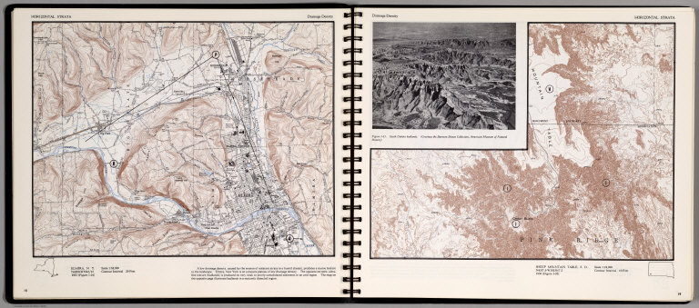
Horizontal Strata. Elmira, N. Y. (on the opposite page)Sheep Mountain table, S.D. 1:24,000. (on top of the page) Dendritic Drainage. (inset view) South Dakota Badlands.(Courtesy of Barnum Brown Collection ...)
List No
0889.013
Note
Two contour maps, includes text, and outline location map. Relief shown by contours and spot height.
Author
Thayer, H. L.
Full Title
(Covers to) Thayer's Map of the Black Hills & Big Horn Country. Published By H.L Thayer Denver, Colorado. Carefully prepared from the Official Maps of the General Land Office. Explorations of Capt. Wm. Ludlow and from latest Maps of the routes of General Custer and other Officers of the Army, furnished by Capt. W.S. Stanton Chief Engr. Dept. of the Platte and from the Engineer Dept. at Washington. Entered ... 1877 by H.L. Thayer ... Washington. Edward Rollandet, Draftsman.
List No
0993.001
Note
Rare. One of the earlier Black Hills pocket maps. Wheat: "An imposing production." Border color by state. Map is folded into dark brown cloth covers 15.5x9.5 with purple label reading "Thayer's Map Of The Black Hills And Big Horn Country . One Dollar."
Author
Thayer, H. L.
Full Title
Thayer's Map of the Black Hills & Big Horn Country. Published By H.L Thayer Denver, Colorado. Carefully prepared from the Official Maps of the General Land Office. Explorations of Capt. Wm. Ludlow and from latest Maps of the routes of General Custer and other Officers of the Army, furnished by Capt. W.S. Stanton Chief Engr. Dept. of the Platte and from the Engineer Dept. at Washington. Entered ... 1877 by H.L. Thayer ... Washington. Edward Rollandet, Draftsman.
List No
0993.002
Note
Rare. One of the earlier Black Hills pocket maps. Wheat: "An imposing production." Border color by state. Map is folded into dark brown cloth covers 15.5x9.5 with purple label reading "Thayer's Map Of The Black Hills And Big Horn Country . One Dollar."
Author
U.S. General Land Office
Full Title
Dakota Territory. Department of the Interior, General Land Office, October 2nd 1866. Jo. S. Wilson, Commissioner. The Major & Knapp Eng. Mfg. & Lith. Co. 71 Broadway, N.Y.
List No
1070.008
Note
The territory is largely unsurveyed. Surveying has only been completed in a few townships right along the Missouri River. The map shows the treaty line of July 23, 1851.
Author
U.S. General Land Office
Full Title
(Map 11 - Wyoming, Nebraska, Colorado, Kansas, South Dakota).
List No
1071.013
Note
One of the series of adjacent sixteen maps. Mounted on linen. Relief shown in hachures.
Author
U.S. General Land Office
Full Title
Department of the Interior, General Land Office. S.S. Burdett, Commissioner.Territory of Dakota. 1876. Compiled from the official records of the General Land Office and other sources by C. Roeser, Principal Draughtsman G.L.O. Photolith. & Print by Julius Bien 16 & 18 Park Place, N.Y.
List No
11179.008
Note
Color map. Includes references. Relief shown by hachures. Prime meridian is Greenwich.
Author
Warren, Gouverneur Kemble, 1830-1882
Full Title
(Title Page to) Explorations in the Dacota Country, in the Year 1855. By Lieut. G.K. Warren, Topographical Engineer of the "Sioux Expedition." Senate. 34th Congress, 1st Session. Ex. Doc. No. 76. Washington: A.O.P. Nicholson, Senate Printer. 1856. (with map) Reconnoissances in the Dacota Country By G.K. Warren, Lieut: Topl. Engrs. U.S.A. ... P.S. Duval & Co. Lith. Philada. (profile) Profile Of Route From Fort Pierre To Fort Kearney ... 1855.
List No
1172A
Author
Warren, Gouverneur Kemble, 1830-1882
Full Title
Reconnoissances in the Dacota Country By G.K. Warren, Lieut: Topl. Engrs. U.S.A. ... P.S. Duval & Co. Lith. Philada. (profile) Profile Of Route From Fort Pierre To Fort Kearney ... 1855.
List No
1172.001
Note
The large map, 92x153, "Reconnoissances in the Dacota Country", is one of the most detailed, large scale maps of eastern Nebraska of the period. Map is without color. Bound with new cloth covered boards, "Explorations in the Dacota Country, G.K. Warren, 1856" on spine.
Author
[Warren, G.K., U. S. Army. Corps of Engineers]
Full Title
Map Of Nebraska And Dakota, And Portions Of The States And Territories Bordering Thereon, Compiled By Bv't Maj. Gen. G.K. Warren, Maj. Engineers. March, 1867 ... Engineer Dep't U.S. Army. Bv't Maj. Gen. A.A. Humphreys, Chief Of Engineers.
List No
1173.000
Note
Later version of 1858 edition. Includes routes, surveys and reconnaissances indexed by dates and name of person in charge. Not in Wheat. Unfolded separate issue. In two sheets; without color. Relief shown by hachures.
|