|
REFINE
Browse All : Images of South Carolina and North Carolina from U.S. Civil War
1-12 of 12
Author
Bachmann, John
Full Title
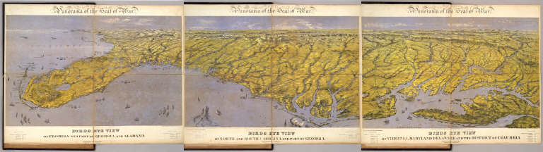
(Composite of) Panorama of the Seat of War. Birds eye view of Florida and part of Georgia and Alabama .. North and South Carolina and part of Georgia .. Virginia, Maryland, Delaware and the District of Columbia. John Bachmann, Publisher, 115 & 117 Nassau St., New York. Entered ... 1861 by John Bachmann ... New York. Drawn from Nature and Lith. by John Bachmann.
List No
5491.000
Note
Composite map image from three separate issues.
Author
[Duane, James C., United States. War Department]
Full Title
Map showing the operations of the Army of the Potomac under command of Maj. Gen. George G. Meade, from March 29th to April 9th, 1865. J.C. Duane, Major of Engineers ... (with) Map of portions of Mississippi, Alabama and Georgia showing march of Cavalry Corps, Military Division of the Mississippi, from March 22d to April 20th 1865. (with) No. 3. Map showing routes of marches of the army of Gen. W.T. Sherman from Atlanta, Ga. to Goldsborough, N.C. ... (with) Plat showing the battle-ground at Rivers' Bridge, Big Salkehatchie River, S.C. (with) Chart accompanying project for effectually closing Cape Fear River and the port of Wilmington, N.C. to blockade runners. (with) Plans, sections and elevation of pile bridge, James River near Varina, Va., January 1865. W.R. King, 1st Lieut. U.S. Engrs. ... Julius Bien & Co., Lith., N.Y. (1891-1895)
List No
1780.076
Note
Col. map with 4 ancillary maps and 1 panel of sections. Accompany reports and letters of of J.H. Wilson, O.O. Howard, Q.A. Gillmore and George G. Meade
Author
United States. War Department
Full Title
Map of the environs of Petersburg, Va. from the Appomattox River to Ft. Howard, showing the positions of the intrenched lines occupied by the 9th Army Corps, A.P., during the siege. Plat showing the positions of the Army of the Tennessee under command of Maj. Gen. O.O. Howard during the battle of Bentonville, N.C., March 20th and 21st 1865. Map showing the march routes of the Army of the Tennessee under the command of Maj. Gen. O.O. Howard during the winter campaign in the Carolinas. Surveyed and compiled under the direction of Col. C.B. Reese ... Drawn and compiled by L. Helmle ... Surveys by W. Griswold and J. Weld ... Topographical map showing the positions of the 14th and 20th Corps commanded by Maj. Gen. H.W. Slocum, and Kilpatrick's Cavalry in an engagement near Bentonville, N.C., March 19th, 1865. R.M. McDowell, Capt. and Top. Engr, Army of Ga. Map of battle of Averysborough, N.C., fought March 16th, 1865. Map of the battle-field of Pea Ridge, Ark. showing the positions of the United States and Confederate forces on the 8th of March, 1862. ... Published ... 1876. Plan no. 8, siege operations at Spanish Fort, Mobile Bay, by the U.S. forces under Maj. Gen. E.R. Canby. Captured by the Army of West Mississippi, on the night of April 8 and 9, 1865, Major M.D. McAlester, Senior Engr., Major J.C. Palfrey, Asst. Engr., Capt. C.J. Allen, Asst. Engr., Capt. Patten ... Asst. Engr. Julius Bien & Co., Lith., N.Y. (1891-1895)
List No
1780.079
Note
Seven col. maps. Relief shown by hachures. Carolinas map in 2 segments.
Author
[Asmussen, Charles W., United States. War Department]
Full Title
Campaign maps exhibiting the line of march of the 20th Corps from Savannah, Ga. to Goldsborough, N.C., with the plans of the battle-fields of Averysborough and Bentonville, N.C., from surveys of Topographical Engineers 20th Corps. Position of troops by Lieut. Col. C.W. Asmussen ... Rough sketch of Taylor's store, Ala. and surrounding country. Julius Bien & Co., Lith., N.Y. (1891-1895)
List No
1780.080
Note
Twelve col. maps. Relief shown by hachures. "Title to maps 1 to 11 inclusive;" map 12 is Taylor's Store sketch. Maps 10 and 11 also have separate titles: Map showing the positions of the 14th and 20th Corps and Kilpatrick's cavalry in an engagement near Bentonville, N.C., March 19th, 1865. R.M. McDowell, Capt. and Topl. Engr., 20th Corps -- Map of battle of Black River, N.C., fought March 16th, 1865, Averysborough. Accompanying reports and letters of H.W. Slocum, Patton Anderson and A.S. Williams.
Author
United States. War Department
Full Title
Campaign maps accompanying report of Bvt. Maj. Gen. J.W. Geary, U.S. Army, for the campaign from Savannah, Ga. to Goldsborough, N.C. 2d Division, 20th Corps. Campaign maps to accompany report of Bvt. Maj. Gen. J.W. Geary, U.S. Army for the campaign from Goldsborough, S.C. to Washington, D.C. 2d Division, 20th Corps, by Capt. O.L.F. Browne, A.T. Engr., 2d Division, 20th Corps. Operations about Bottom's Bridge, Va., May 20-23, 1862. Julius Bien & Co., Lith., N.Y. (1891-1895)
List No
1780.086
Note
17 col. maps. Relief shown by hachures. "Title to maps 1 to 7 inclusive," "Title to maps nos. 8 to 16 inclusive."
Author
[Campbell, Albert H., Confederates States of America. Army of Northern Virginia, Henderson, D. E.]
Full Title
Chief Engineer's Office, D.N.V. Maj. Gen. J.F. Gilmer, Chief Engineer. Map of Spotsylvania County. Made under direction of A.H. Campbell, Capt. Engrs. in chg. Topl. Dept. General map. The vicinity of Hanover Junction, Va. and its defenses. Made under the direction of Capt. A.H. Campbell ... by Lieut. D.E. Henderson, Provl. Engrs., C.S. Army. (with) D. Sketch showing route pursued in the advance to Goldsborough, N.C. in December 1862. (with) Sketch showing position of Boyd's Neck, Honey Hill and Devaux's Neck, S.C. in December 1864. (with) Sketch of Spanish Fort defenses made during the siege by Lieut. J.A. Chalaron. Julius Bien & Co., Lith., N.Y. (1891-1895)
List No
1780.091
Note
Two col. maps, with 3 insets and 3 ancillary maps. Relief shown by hachures.
Author
[Confederate States of America. Army, Confederate States of America. Army. Corps of Engineers, Walker, William A.]
Full Title
Map of Charleston and its defenses, compiled from surveys of portions of St. Andrew's and Christ Ch. parishes by Lieut. John Johnson, C.S. Engrs ... Under the direction of Maj. Wm. H. Echols, C.S. Engr's Corps ... by Wm. A Walker, draughtsman ... Drawn by John R. Key ... Charleston, S.C., Nov. 28th 1863. (with) Map of New Berne, N.C. and defenses. Copied from Cleveland Rockwell's U.S. Coast Survey chart of New Berne and approaches, with additions under the direction of Lieut. Wm. R. King, U.S. Eng'rs. by Solon M. Allis, 27th Mass., July 1864. (with) Diagrams illustrating the 1st and 7th positions occupied by the 4th Division, 17th Army Corps, during the battle of Atlanta, Ga., July 22, 1864. Julius Bien & Co., Lith., N.Y. (1891-1895)
List No
1780.131
Note
Col. map with 2 ancillary maps. Depths shown by soundings. "The harbor, James Id, Folly Id, Morris Id., Sullivan's Id. and Long Id. from United States Coast Survey. John's Id. from Mills' atlas." "Copied for his excellency M.I. Bonham, Governor of the state of South Carolina." Ancillary maps from reports of Peter S. Michie and Giles A. Smith.
Author
[Twining, William J., United States. War Department]
Full Title
Map of Fort Anderson, N.C. Captured February 19th 1865 by the Army of the Ohio. Maj. Gen. J.M. Schofield, Comd'g. Official Wm. J. Twining, Capt. and Ch'f. Engr. (with) Map of Franklin, Tenn. Including field works and positions of troops 4th and 23rd Corps, during the engagement of November 30th 1864. Maj. Gen. Schofield, Comd'g. ... (with) Map of the battle-field of Droop Mountain drawn from a partial survey by Henry Topping. 6th Nov. 1863. (with) Battle-ground near White Sulphur Springs. August 26 and 27, 1863. Drawn by Lieut. J.R. Meigs, U.S. Engrs. (with Savannah and Wright rivers, S.C., Feb. 6, 1862). Accompanying report of Maj. O.T. Beard ... Julius Bien & Co., Lith., N.Y. (1891-1895)
List No
1780.137
Note
Col. map with 5 ancillary maps. Relief shown by hachures.
Author
Bachmann, John
Full Title
(Covers to) Panorama of the Seat of War. Birds Eye View Of North And South Carolina And Part Of Georgia. John Bachmann, Publisher, 115 & 117 Nassau St., New York. Entered ... 1861 by John Bachmann ... New York. Drawn from Nature and Lith. by John Bachmann.
List No
2664A
Author
Bachmann, John
Full Title
Panorama of the Seat of War. Birds Eye View Of North And South Carolina And Part Of Georgia. John Bachmann, Publisher, 115 & 117 Nassau St., New York. Entered ... 1861 by John Bachmann ... New York. Drawn from Nature and Lith. by John Bachmann.
List No
2664.001
Note
Shows shelling of Ft. Hatteras. Stephenson shows an earlier issue (304.5) that does not have Bachmann's name as publisher, nor the phrase "drawn from nature and lith. by John Bachmann." Full color. Bound in black leather covers 38x30 with "North & South Carolina, Part of Georgia. G.G.W." stamped in gold.
Author
Colton, J. H.
Full Title
Colton's New Topographical Map Of The Eastern Portion Of The State Of North Carolina With Part Of Virginia & South Carolina From The Latest & Best Authorities. Published by J.H. Colton, No. 172 William St. N.Y. 1863. Entered ... 1860 by J.H. Colton ... New York. Printed by Lang & Cooper, 117 Fulton St. N.Y. (inset) Plan Of The Sea Coast From Virginia To Florida.
List No
3044.000
Note
1st issued 1861. Last issue 1864. With an inset "Plan of the Sea Coast From Virginia to Florida." This map is a companion map to Colton's Topographical Map of the Seat of War in Virginia, Maryland, &c. (see our copy), but on a larger scale (8 miles to an inch vs. 12 miles). It is both highly detailed (railroads, physical features, towns, counties, etc.) and highly decorative (many ships illustrated off the coasts). Map has outline color by state and water painted in blue; inset has full color by state.
Author
Engineer Bureau War Dept
Full Title
Map Showing Route of Marches of the Army of Genl. W.T. Sherman From Atlanta, Ga. to Goldsboro, N.C. To accompany the report of operations From Savannah, Ga. to Goldsboro, N.C. Engineer Bureau. War Department. Prepared by Order of the Secretary of War For the Officers of the U.S. Army under the Command of Maj. Gen. W.T. Sherman.
List No
3855.000
Note
Smaller version of the larger Sherman campaign map, reduced to accompany a report. Color used to show the army march routes. Relief shown by hachures.
1-12 of 12
|