|
Author
Thomson, John
Full Title
Dumbartonshire. Sur(veye)d by Wood for the Atlas of Scotland. (with view) Dumbarton Castle. Engraved by Sid(ne)y Hall, Bury Strt. Bloomsby. (with town of Dumbarton). Published by John Thomson & Co., Edinburgh, 1823. (1832)
List No
5748.042
Note
Hand colored engraved map. Relief shown by hachures. Shows settlements, roads, etc.
Author
Thomson, John
Full Title
Buteshire. Engraved by S.I. Neele & Son, 352 Strand. Published by John Thomson & Co., Edinburgh, 1823. (1832)
List No
5748.043
Note
Hand colored engraved map. Relief shown by hachures. Shows settlements, roads, etc.
Author
Thomson, John
Full Title
Northern part of Argyllshire. Drawn by W. Johnson, Edinr. Engd. by J. & G. Menzies, Edinr. Published by John Thomson & Co., Edinburgh, 1824. (1832)
List No
5748.044
Note
Hand colored engraved map. Relief shown by hachures. Shows settlements, roads, etc. Includes inset map of Coll and Tirree islands. David Rumsey Collection copy: imprint cropped.
Author
Thomson, John
Full Title
Southern part of Argyllshire. (with) Campbeltown. Drawn by W. Johnson, Edinr. Engd. by J. & G. Menzies, Edinr. Published by John Thomson & Co., Edinburgh, 1824. (1832)
List No
5748.045
Note
Hand colored engraved map. Relief shown by hachures. Shows settlements, roads, etc. Includes inset map of part of Cantire.
Author
Thomson, John
Full Title
(Composite of) Northern part ... Southern part of Argyllshire. (with) Campbeltown. Drawn by W. Johnson, Edinr. Engd. by J. & G. Menzies, Edinr. Published by John Thomson & Co., Edinburgh, 1824. (1832)
List No
5748.046
Note
Digital composite of 2 hand colored engraved maps. Relief shown by hachures. Shows settlements, roads, etc. Includes inset maps of Coll and Tirree islands and part of Cantire.
Author
[Johnson, William, fl. 1806-1840, Storie, James, Thomson, John]
Full Title
North west part of Perthshire. From Mr. James Storie's survey by William Johnson, Land Surveyor. Engraved by Sid(ne)y Hall, Bury Strt., Bloomsby. Published by John Thomson, Edinburgh, 1827. (1832)
List No
5748.047
Note
Hand colored engraved map. Relief shown by hachures. Shows settlements, roads, etc. Prime meridian: Edinburgh.
Author
[Johnson, William, fl. 1806-1840, Storie, James, Thomson, John]
Full Title
North east part of Perthshire. From Mr. James Storie's survey by William Johnson, Land Surveyor. Engraved by Sid(ne)y Hall, Bury Strt., Bloomsby. Published by John Thomson, Edinburgh, 1827. (1832)
List No
5748.048
Note
Hand colored engraved map. Relief shown by hachures. Shows settlements, roads, etc. Prime meridian: Edinburgh.
Author
[Johnson, William, fl. 1806-1840, Storie, James, Thomson, John]
Full Title
South west part of Perthshire. From Mr. James Storie's survey by William Johnson, Land Surveyor. Engraved by Sid(ne)y Hall, Bury Strt., Bloomsby. Published by John Thomson, Edinburgh, 1827. (1832)
List No
5748.049
Note
Hand colored engraved map. Relief shown by hachures. Shows settlements, roads, etc. Prime meridian: Edinburgh.
Author
[Johnson, William, fl. 1806-1840, Storie, James, Thomson, John]
Full Title
South east part of Perthshire with Clackmannan. (with Perth). From Mr. James Storie's survey by William Johnson, Land Surveyor. Engraved by Sid(ne)y Hall, Bury Strt., Bloomsby. Published by John Thomson, Edinburgh, 1827. (1832)
List No
5748.050
Note
Hand colored engraved map. Relief shown by hachures. Shows settlements, roads, etc. Prime meridian: Edinburgh.
Author
[Johnson, William, fl. 1806-1840, Storie, James, Thomson, John]
Full Title
(Composite of) ... Part of Perthshire with Clackmannan. (with Perth). From Mr. James Storie's survey by William Johnson, Land Surveyor. Engraved by Sid(ne)y Hall, Bury Strt., Bloomsby. Published by John Thomson, Edinburgh, 1827. (1832)
List No
5748.051
Note
Digital composite of 4 hand colored engraved maps. Relief shown by hachures. Shows settlements, roads, etc. Prime meridian: Edinburgh.
Author
[Drysdale, Robert, Johnson, William, fl. 1806-1840, Martin, Alexander, Thomson, John]
Full Title
Western part of Fife with Kinross-Sh(ire). Compiled from the surveys of John Ainslie & John Bell. Corrected by Alexander Martin, surveyor, Cupar; Robt. Drysdale, surr. Dunfermline, and William Johnson, surveyor, Edinr. Eng. by E. Butterworth. Published by John Thomson, Edinburgh, 1831. (1832)
List No
5748.052
Note
Hand colored engraved map. Relief shown by hachures. Shows settlements, roads, etc.
Author
[Drysdale, Robert, Johnson, William, fl. 1806-1840, Martin, Alexander, Thomson, John]
Full Title
Eastern part of Fife-Sh(ire). Compiled from the surveys of John Ainslie & John Bell. Corrected by Alexr. Martin, surveyor, Cupar; Robt. Drysdale, surr. Dunfermline, and William Johnson, surveyor, Edinr. Eng. by E. Butterworth. Published by John Thomson, Edinburgh, 1831. (1832)
List No
5748.053
Note
Hand colored engraved map. Relief shown by hachures. Shows settlements, roads, etc.
Author
[Drysdale, Robert, Johnson, William, fl. 1806-1840, Martin, Alexander, Thomson, John]
Full Title
(Composite of) Western part of Fife with Kinross-Sh(ire). Eastern part of Fife-Sh(ire). Compiled from the surveys of John Ainslie & John Bell. Corrected by Alexander Martin, surveyor, Cupar; Robt. Drysdale, surr. Dunfermline, and William Johnson, surveyor, Edinr. Eng. by E. Butterworth. Published by John Thomson, Edinburgh, 1831. (1832)
List No
5748.054
Note
Digital composite of 2 hand colored engraved maps. Relief shown by hachures. Shows settlements, roads, etc.
Author
Thomson, John
Full Title
Northern part of Angusshire. Engraved by Sid(ne)y Hall, Bury Strt., Bloomsby. Published by John Thomson & Co., Edinburgh, 1825. (1832)
List No
5748.055
Note
Hand colored engraved map. Relief shown by hachures. Shows settlements, roads, etc.
Author
Thomson, John
Full Title
Southern part of Angusshire. Engraved by Sid(ne)y Hall, Bury Strt., Bloomsby. Published by John Thomson & Co., Edinburgh, 1825. (1832)
List No
5748.056
Note
Hand colored engraved map. Relief shown by hachures. Shows settlements, roads, etc.
Author
Thomson, John
Full Title
(Composite of) Northern part of Angusshire. Southern part of Angusshire. Engraved by Sid(ne)y Hall, Bury Strt., Bloomsby. Published by John Thomson & Co., Edinburgh, 1825. (1832)
List No
5748.057
Note
Digital composite of 2 hand colored engraved maps. Relief shown by hachures. Shows settlements, roads, etc.
Author
Thomson, John
Full Title
Kincardine Shire. (with) A north east view of Dunnotar Castle. Drawn by Wm. Johnson, Edinh. Engd. by Hewitt, London. Published by John Thomson, Edinburgh, 1831. (1832)
List No
5748.058
Note
Hand colored engraved map. Relief shown by hachures. Shows settlements, roads, etc.
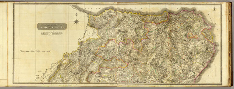
Author
Thomson, John
Full Title
Northern part of Aberdeen & Banff-Shrs. Eng. by J. & G. Menzies, Edinr. Published by John Thomson, Edinburgh, 1826. (1832)
List No
5748.059
Note
Hand colored engraved map (western sheet). Relief shown by hachures. Shows settlements, roads, etc.
Author
Thomson, John
Full Title
(Northern part of Aberdeen & Banff-Shrs.) Eng. by J. & G. Menzies, Edinr. Published by John Thomson, Edinburgh, 1826. (1832)
List No
5748.060
Note
Hand colored engraved map (eastern sheet). Relief shown by hachures. Shows settlements, roads, etc.
Author
Thomson, John
Full Title
(Composite of) Northern part of Aberdeen & Banff-Shrs. Eng. by J. & G. Menzies, Edinr. Published by John Thomson, Edinburgh, 1826. (1832)
List No
5748.061
Note
Digital composite of hand colored engraved map on 2 sheets. Relief shown by hachures. Shows settlements, roads, etc.
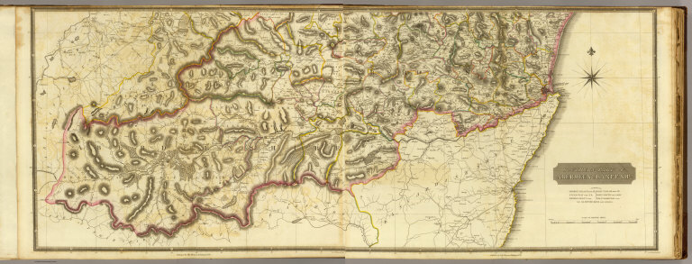
Author
Thomson, John
Full Title
(Southern part of Aberdeen & Banff-Shrs.) Eng. by E. Butterworth, Edinr. Published by John Thomson, Edinburgh, 1826. (1832)
List No
5748.062
Note
Hand colored engraved map (western sheet). Relief shown by hachures. Shows settlements, roads, etc.
Author
Thomson, John
Full Title
Southern part of Aberdeen & Banff-Shrs. Eng. by E. Butterworth, Edinr. Published by John Thomson, Edinburgh, 1826. (1832)
List No
5748.063
Note
Hand colored engraved map (eastern sheet). Relief shown by hachures. Shows settlements, roads, etc.
Author
Thomson, John
Full Title
(Composite of) South Aberdeen & Banff-Shrs. Eng. by E. Butterworth, Edinr. Published by John Thomson, Edinburgh, 1826. (1832)
List No
5748.064
Note
Digital composite of hand colored engraved map on 4 sheets. Relief shown by hachures. Shows settlements, roads, etc.
Author
Thomson, John
Full Title
(Composite of) Aberdeen & Banff-Shrs. Eng. by E. Butterworth, Edinr. Published by John Thomson, Edinburgh, 1826. (1832)
List No
5748.065
Note
Digital composite of hand colored engraved map on 4 sheets. Relief shown by hachures. Shows settlements, roads, etc.
Author
[Johnson, William, fl. 1806-1840, Thomson, John]
Full Title
Nairn and Elgin. Compiled by William Johnson. Engraved by T. Clerk, Edinr. Published by John Thomson, Edinburgh, 1830. (1832)
List No
5748.066
Note
Hand colored engraved map. Relief shown by hachures. Shows settlements, roads, etc.
Author
[Johnson, William, fl. 1806-1840, Thomson, John]
Full Title
Part of Inverness Shire. Skye Island &c. From actual survey ... by William Johnson, Land Surveyor. Drawn by William Johnson, Edinr. Engraved by S.I. Neele & Son, 352 Strand. Published by John Thomson & Co., , Edinburgh, 1824. (1832)
List No
5748.067
Note
Hand colored engraved map. Relief shown by hachures. Shows settlements, roads, etc.
Author
Thomson, John
Full Title
Middle part of Western Isles. Part of Inverness Sh. From actual surveys. Drawn by Wm. Johnson, Edinr. Engd. by W. Dassauville, Edinr. Published by John Thomson & Co., Edinburgh, 1822. (1832)
List No
5748.068
Note
Hand colored engraved map. Relief shown by hachures. Shows settlements, roads, etc. Oriented with north toward upper right.
Author
Thomson, John
Full Title
Southern part of Western Isles. Part of Inverness Sh. From actual surveys. Drawn by W. Johnson, Edinr. Engd. by W. Dassauville, Edinr. Published by John Thomson & Co., Edinburgh, 1823. (1832)
List No
5748.069
Note
Hand colored engraved map. Relief shown by hachures. Shows settlements, roads, etc. Oriented with north toward upper right.
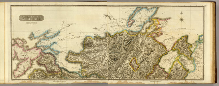
Author
[Johnson, William, fl. 1806-1840, Thomson, John]
Full Title
Northern part of Inverness Shire. Compiled by William Johnson, Land Surveyor, Edinburgh. (Engraved by) J. & G. Menzies, Edinr. Published by John Thomson & Co., Edinburgh, 1830. (1832)
List No
5748.070
Note
Hand colored engraved map (western half). Relief shown by hachures. Shows settlements, roads, etc.
Author
Thomson, John
Full Title
(Northern part of Inverness Shire. Compiled by William Johnson, Land Surveyor, Edinburgh. Engraved by) J. & G. Menzies, Edinr. Published by John Thomson & Co., Edinburgh, 1830. (1832)
List No
5748.071
Note
Hand colored engraved map (eastern half). Relief shown by hachures. Shows settlements, roads, etc.
Author
[Johnson, William, fl. 1806-1840, Thomson, John]
Full Title
(Composite of) Northern part of Inverness Shire. Compiled by William Johnson, Land Surveyor, Edinburgh. (Engraved by) J. & G. Menzies, Edinr. Published by John Thomson & Co., Edinburgh, 1830. (1832)
List No
5748.072
Note
Digital composite of hand colored engraved map on 2 sheets. Relief shown by hachures. Shows settlements, roads, etc.
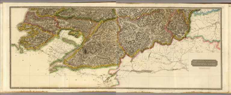
Author
Thomson, John
Full Title
(Southern part of Inverness Shire. Compiled by William Johnson, Land Surveyor, Edinburgh. Engraved by) J. & G. Menzies, Edinr. Published by John Thomson & Co., Edinburgh, 1830. (1832)
List No
5748.073
Note
Hand colored engraved map (western half). Relief shown by hachures. Shows settlements, roads, etc.
Author
[Johnson, William, fl. 1806-1840, Thomson, John]
Full Title
Southern part of Inverness Shire. Compiled by William Johnson, Land Surveyor, Edinburgh. (Engraved by) J. & G. Menzies, Edinr. Published by John Thomson & Co., Edinburgh, 1830. (1832)
List No
5748.074
Note
Hand colored engraved map (eastern half). Relief shown by hachures. Shows settlements, roads, etc.
Author
[Johnson, William, fl. 1806-1840, Thomson, John]
Full Title
(Composite of) Southern part of Inverness Shire. Compiled by William Johnson, Land Surveyor, Edinburgh. (Engraved by) J. & G. Menzies, Edinr. Published by John Thomson & Co., Edinburgh, 1830. (1832)
List No
5748.075
Note
Digital composite of hand colored engraved map on 2 sheets. Relief shown by hachures. Shows settlements, roads, etc.
Author
[Johnson, William, fl. 1806-1840, Thomson, John]
Full Title
(Composite of) Inverness Shire. Compiled by William Johnson, Land Surveyor, Edinburgh. (Engraved by) J. & G. Menzies, Edinr. Published by John Thomson & Co., Edinburgh, 1830. (1832)
List No
5748.076
Note
Digital composite of hand colored engraved map on 4 sheets. Relief shown by hachures. Shows settlements, roads, etc.
Author
Thomson, John
Full Title
Northern part of Western Isles. Part of Ross Shire. From actual surveys. Drawn by Wm. Johnson, Edinr. Engd. by W. Dassauville, Edinr. Published by John Thomson & Co., Edinburgh, 1822. (1832)
List No
5748.077
Note
Hand colored engraved map. Relief shown by hachures. Shows settlements, roads, etc. Oriented with north toward upper right.
Author
[Craig, John, Thomson, John]
Full Title
Northern part of Ross and Cromarty Shires. Compiled from actual surveys by John Craig. Published by John Thomson, Edinburgh, 1826. (1832)
List No
5748.078
Note
Hand colored engraved map. Relief shown by hachures. Shows settlements, roads, etc.
Author
[Craig, John, Thomson, John]
Full Title
Southern part of Ross and Cromarty Shires. (with) Lewis, part of Ross Shire. Compiled from actual surveys by John Craig. Published by John Thomson, Edinburgh, 1826. (1832)
List No
5748.079
Note
Hand colored engraved map. Relief shown by hachures. Shows settlements, roads, etc.
Author
[Craig, John, Thomson, John]
Full Title
(Composite of) Northern part ... Southern part of Ross and Cromarty Shires. (with) Lewis, part of Ross Shire. Compiled from actual surveys by John Craig. Published by John Thomson, Edinburgh, 1826. (1832)
List No
5748.080
Note
Digital composite of 2 hand colored engraved maps. Relief shown by hachures. Shows settlements, roads, etc.
Author
Thomson, John
Full Title
Sutherland Shire. Engraved by S.I. Neele & Son, 352 Strand. Published by John Thomson & Co., Edinburgh, 1823. (1832)
List No
5748.081
Note
Hand colored engraved map. Relief shown by hachures. Shows settlements, roads, etc.
Author
Thomson, John
Full Title
Caithness Shire. Drawn by Wm. Campbell, Keiss. Engraved by T. Clerk, Edinburgh. Published by John Thomson & Co., Edinburgh, 1822. (1832)
List No
5748.082
Note
Hand colored engraved map. Relief shown by hachures. Shows settlements, roads, etc.
Author
Thomson, John
Full Title
Orkney Islands. Engraved by T. Clerk. Published by John Thomson & Co., Edinburgh, 1822. (1832)
List No
5748.083
Note
Hand colored engraved map. Relief shown by hachures. Shows settlements, roads, etc.
Author
Thomson, John
Full Title
Shetland Islands. Drawn by William Johnson, Edinr., 1827. Engd. by J. Moffat, Edinr. Published by John Thomson, Edinburgh, 1827. (1832)
List No
5748.084
Note
Hand colored engraved map. Relief shown by hachures. Shows settlements, roads, etc.
Author
Thomson, John
Full Title
(Index Page to) The atlas of Scotland, containing maps of each county, on a scale so large as to exhibit the features of the country, and places of importance; the boundaries of the shires ... Accompanied with a Memoir of the geography of Scotland, view of the comparative length of the rivers, height of the mountains, and a consulting index, to facilitate the finding out of places, &c. Edinburgh: Printed for John Thomson & Co., Edinburgh; Baldwin & Cradock, London; and John Cumming, Dublin. 1832.
List No
5748M
Note
Consulting index for the Atlas of Scotland. Edinburghshire--Map no. I.
Author
Thomson, John
Full Title
(Index Page to) The atlas of Scotland, containing maps of each county, on a scale so large as to exhibit the features of the country, and places of importance; the boundaries of the shires ... Accompanied with a Memoir of the geography of Scotland, view of the comparative length of the rivers, height of the mountains, and a consulting index, to facilitate the finding out of places, &c. Edinburgh: Printed for John Thomson & Co., Edinburgh; Baldwin & Cradock, London; and John Cumming, Dublin. 1832.
List No
5748N
Note
Consulting index for the Atlas of Scotland. Haddingtonshire--Map no. II, Berwickshire--Map no. III.
Author
Thomson, John
Full Title
(Index Page to) The atlas of Scotland, containing maps of each county, on a scale so large as to exhibit the features of the country, and places of importance; the boundaries of the shires ... Accompanied with a Memoir of the geography of Scotland, view of the comparative length of the rivers, height of the mountains, and a consulting index, to facilitate the finding out of places, &c. Edinburgh: Printed for John Thomson & Co., Edinburgh; Baldwin & Cradock, London; and John Cumming, Dublin. 1832.
List No
5748O
Note
Consulting index for the Atlas of Scotland. Roxburghshire--Map no. IV, Selkirkshire--Map no. V, Dumfries-shire-- Map no. VI.
Author
Thomson, John
Full Title
(Index Page to) The atlas of Scotland, containing maps of each county, on a scale so large as to exhibit the features of the country, and places of importance; the boundaries of the shires ... Accompanied with a Memoir of the geography of Scotland, view of the comparative length of the rivers, height of the mountains, and a consulting index, to facilitate the finding out of places, &c. Edinburgh: Printed for John Thomson & Co., Edinburgh; Baldwin & Cradock, London; and John Cumming, Dublin. 1832.
List No
5748P
Note
Consulting index for the Atlas of Scotland. Kirkcudbrightshire--Map no. VII, Wigtonshire--Map no. VIII.
Author
Thomson, John
Full Title
(Index Page to) The atlas of Scotland, containing maps of each county, on a scale so large as to exhibit the features of the country, and places of importance; the boundaries of the shires ... Accompanied with a Memoir of the geography of Scotland, view of the comparative length of the rivers, height of the mountains, and a consulting index, to facilitate the finding out of places, &c. Edinburgh: Printed for John Thomson & Co., Edinburgh; Baldwin & Cradock, London; and John Cumming, Dublin. 1832.
List No
5748Q
Note
Consulting index for the Atlas of Scotland. Ayrshire--Map no. IX, Peebles-shire--Map no. X.
Author
Thomson, John
Full Title
(Index Page to) The atlas of Scotland, containing maps of each county, on a scale so large as to exhibit the features of the country, and places of importance; the boundaries of the shires ... Accompanied with a Memoir of the geography of Scotland, view of the comparative length of the rivers, height of the mountains, and a consulting index, to facilitate the finding out of places, &c. Edinburgh: Printed for John Thomson & Co., Edinburgh; Baldwin & Cradock, London; and John Cumming, Dublin. 1832.
List No
5748R
Note
Consulting index for the Atlas of Scotland. Lanarkshire--Map no. XI.
Author
Thomson, John
Full Title
(Index Page to) The atlas of Scotland, containing maps of each county, on a scale so large as to exhibit the features of the country, and places of importance; the boundaries of the shires ... Accompanied with a Memoir of the geography of Scotland, view of the comparative length of the rivers, height of the mountains, and a consulting index, to facilitate the finding out of places, &c. Edinburgh: Printed for John Thomson & Co., Edinburgh; Baldwin & Cradock, London; and John Cumming, Dublin. 1832.
List No
5748S
Note
Consulting index for the Atlas of Scotland. Renfrewshire--Map no. XII, Linlithgowshire--Map no. XIII, Stirlingshire--Map no. XIV.
|