|
REFINE
Browse All : Images of San Bernardino County (Calif.) and Los Angeles County (Calif.)
1-17 of 17
Author
[California. State Earthquake Investigation Commission, U.S. Geological Survey]
Full Title
California, San Antonio quadrangle of the U.S. Geological Survey showing the San Andreas Rift. Earthquake Investigation Commission. Andrew B. Graham Co., Lithographers, Washington, D.C. (Carnegie Institution of Washington. 1908)
List No
2130.010
Note
Color. 15-minute topographic quadrangle. Relief shown by contours and spot heights. Covers portions of Los Angeles and San Bernardino counties.
Author
Rand McNally and Company
Full Title
(Covers to) Rand, McNally & Co.'s Large Scale Sectional Map Of Southern California: Embracing The Counties Of Santa Barbara, Ventura, Los Angeles, San Bernadino And San Diego. 1888. Rand, McNally & Co, Map Publishers and Engravers, 148, 150, 152 and 154 Monroe Street, Chicago. Copyright, 1887, by Rand, McNally & Co., Chicago.
List No
3414.001
Note
Vogdes lists a 1887 edition. Shows Southern California from the Mexican boundary to San Luis Obispo County line, with an index of towns. Inside cover has the label of the Bancroft Company. Full printed color by county. Folded into black cloth covers 17.5x10.5 with "Rand, McNally & Co.'s Large Scale Sectional Map Of Southern California." stamped in gold. Relief shown by hachures.
Author
Rand McNally and Company
Full Title
Rand, McNally & Co.'s Large Scale Sectional Map Of Southern California: Embracing The Counties Of Santa Barbara, Ventura, Los Angeles, San Bernadino And San Diego. 1888. Rand, McNally & Co, Map Publishers and Engravers, 148, 150, 152 and 154 Monroe Street, Chicago. Copyright, 1887, by Rand, McNally & Co., Chicago.
List No
3414.002
Note
Vogdes lists a 1887 edition. Shows Southern California from the Mexican boundary to San Luis Obispo County line, with an index of towns. Inside cover has the label of the Bancroft Company. Full printed color by county. Folded into black cloth covers 17.5x10.5 with "Rand, McNally & Co.'s Large Scale Sectional Map Of Southern California." stamped in gold. Relief shown by hachures.
Author
[California. Office of State Engineer, Hall, Wm. Ham. (William Hammond)]
Full Title
Los Angeles & San Bernardino topography. Wm. H. Hall, State Engineer, Sacramento. (circa 1880)
List No
3451.000
Note
Beautiful hand drawn map of the Los Angles-San Bernardino Basin. Pen-and-ink and pencil. Relief shown by hachures. It appears to be a base map on a scale of two miles to an inch, probably preliminary (several of Hall's notations on the edges indicate corrections needed to the topography) and earlier than the 1888 Report titled "Irrigation in California" that had 15 maps that may have been derived from this map. It may also have served as the base for "Drainage area map to accompany report on irrigation and water supply in California" by Wm. Ham. Hall, State Engineer. (188-?). Hall was a famous engineer who was the first state engineer and was responsible for many of the early state water projects (see California Water Atlas). This map does not have any names drawn in except for a few towns, rivers, or railroads lightly penciled in. All the land divisions and city plats are indicated, with mountains, rivers, railroads, roads, arroyos and shorelines shown. Hall also published four maps of the San Joaquin Valley in 1886 (see WH's copy) separately (see Calfornia Water Atlas p.26). "VI." Title and cartographer from verso. "14" on verso.
Author
[Hall, Wm. Ham. (William Hammond), California Department of Engineering]
Full Title
(Detail Irrigation Map); Crafton Sheet. Wm. Ham. Hall, State Engineer. Irrigation Data 1888. Scale 1 1/2 Inches to One Mile. Outlne Map of the Irrigation region of Los Angeles and San Bernadino Counties, California. To Accompany Report on Irrigation and Water Supply. Wm. Ham. Hall, State Engineer, 1888. George Sandow, Draughtsman.
List No
5830.001
Note
Owned by the Water Resources Center Archives call number mG460 B-1 no.12 c.2. Outline (index) map includes watersheds or catchment basins by name, number, and areas in square miles or acres. Index map at a scale of 1:382,000. In color. Shows irrigation from the Santa Ana River in the areas of Crafton and Mentone.
Author
[Hall, Wm. Ham. (William Hammond), California Department of Engineering]
Full Title
California State Engineering Department. Detail Irrigation Map. Santa Monica Sheet. Wm. Ham. Hall, State Engineer. Irrigation Data 1888. Scale 1 1/2 Inches to One Mile. George Sandow, Draughtsman.
List No
5830.002
Note
In color. Shows areas of San Fernando Valley and more southerly irrigation from Ballona Creek, Centinela Creek, and Los Angeles River in the areas of western Los Angeles Basin. Water Resources Center Archives call number mG460 B-1 No. 11 c. 2.
Author
[Hall, Wm. Ham. (William Hammond), California Department of Engineering]
Full Title
California State Engineering Department. Detail Irrigation Map. Los Angeles Sheet. Wm. Ham. Hall, State Engineer. Irrigation Data 1888. Scale 1 1/2 Inches to One Mile. George Sandow, Draughtsman.
List No
5830.003
Note
In color. Shows areas irrigated by the Los Angeles River in the areas of Glendale, Pasadena, Los Angeles, Alhambra, Ramona, and San Gabriel. Water Resources Center Archives call number mG460 B-1 No. 4 c. 2.
Author
[Hall, Wm. Ham. (William Hammond), California Department of Engineering]
Full Title
California State Engineering Department. Detail Irrigation Map. Monrovia Sheet. Wm. Ham. Hall, State Engineer. Irrigation Data 1888. Scale 1 1/2 Inches to One Mile. George Sandow, Draughtsman.
List No
5830.004
Note
In color. Shows areas irrigated by the San Gabriel River and from the south flank of the Sierra Madre, in the areas of Arcadia, Monrovia, Azusa, Covina, Whittier, and El Monte. Water Resources Center Archives call number mG460 B-1 No. 5 c. 2.
Author
[Hall, Wm. Ham. (William Hammond), California Department of Engineering]
Full Title
California State Engineering Department. Detail Irrigation Map. Pomona Sheet. Wm. Ham. Hall, State Engineer. Irrigation Data 1888. Scale 1 1/2 Inches to One Mile. George Sandow, Draughtsman.
List No
5830.005
Note
In color. Shows areas irrigated by water from San Antonio Canyon, San Dimas Canyon, San Jose Creek,and Dalton Canyon. Covers the areas of Glendora, San Dimas, La Verne, Claremont, Pomona, and Diamond Bar. Water Resources Center Archives call number mG460 B-1 No. 7 c. 2.
Author
[Hall, Wm. Ham. (William Hammond), California Department of Engineering]
Full Title
California State Engineering Department. Detail Irrigation Map. Ontario Sheet. Wm. Ham. Hall, State Engineer. Irrigation Data 1888. Scale 1 1/2 Inches to One Mile. George Sandow, Draughtsman.
List No
5830.006
Note
In color. Shows areas irrigated by water from south face of the San Gabriel Mountains including Day's Canyon and Lytle Creek. Covers the areas of Alta Loma, Cucamonga, Fontana, Rialto, and Ontario. Contemporaneous colony of Etiwanda shown. Water Resources Center Archives call number mG460 B-1 No. 6 c. 2.
Author
[Hall, Wm. Ham. (William Hammond), California Department of Engineering]
Full Title
California State Engineering Department. Detail Irrigation Map. San Bernadino Sheet. Wm. Ham. Hall, State Engineer. Irrigation Data 1888. Scale 1 1/2 Inches to One Mile. George Sandow, Draughtsman.
List No
5830.007
Note
In color. Shows areas irrigated by water from south face of the San Bernadino Mountains including Warm Creek, City Creek, and the Santa Ana River. Covers the areas of San Bernadino, Del Rosa, Highland, Colton, Redlands, and Loma Linda. Water Resources Center Archives call number mG460 B-1 No. 9 c. 2.
Author
[Hall, Wm. Ham. (William Hammond), California Department of Engineering]
Full Title
California State Engineering Department. Detail Irrigation Map. Riverside Sheet. Wm. Ham. Hall, State Engineer. Irrigation Data 1888. Scale 1 1/2 Inches to One Mile. George Sandow, Draughtsman.
List No
5830.008
Note
In color. Shows areas irrigated by water from the Santa Ana River. Covers the areas of Riverside, Rincon, and Jurupa Valley. Water Resources Center Archives call number mG460 B-1 No. 8 c. 2.
Author
[Hall, Wm. Ham. (William Hammond), California Department of Engineering]
Full Title
California State Engineering Department. Detail Irrigation Map. Compton Sheet. Wm. Ham. Hall, State Engineer. Irrigation Data 1888. Scale 1 1/2 Inches to One Mile. George Sandow, Draughtsman.
List No
5830.009
Note
In color. Shows areas irrigated by water from the San Gabriel River and wells. Covers the areas of Compton, Palo Verdes, Torrance, Hawthorne, Lynwood, Willow Brook, Dominguez, and Long Beach. Water Resources Center Archives call number mG460 B-1 No. 1 c. 2.
Author
[Hall, Wm. Ham. (William Hammond), California Department of Engineering]
Full Title
California State Engineering Department. Detail Irrigation Map. Downey Sheet. Wm. Ham. Hall, State Engineer. Irrigation Data 1888. Scale 1 1/2 Inches to One Mile. George Sandow, Draughtsman.
List No
5830.010
Note
In color. Shows areas irrigated by water from the San Gabriel River, and Los Coyotes Creek. Covers the areas of Santa Fe Springs, Norwalk, Bellflower, Signal Hill, Cypress, Sunset Beach, and Long Beach. Water Resources Center Archives call number mG460 B-1 No. 3 c. 2.
Author
[Hall, Wm. Ham. (William Hammond), California Department of Engineering]
Full Title
California State Engineering Department. Detail Irrigation Map. Anaheim Sheet. Wm. Ham. Hall, State Engineer. Irrigation Data 1888. Scale 1 1/2 Inches to One Mile. George Sandow, Draughtsman.
List No
5830.011
Note
In color. Shows areas irrigated by water from the Santa Ana River, and Canada de la Brea. Covers the areas of La Habra, Placentia, Brea, Fullerton, Anaheim, and Orange. Water Resources Center Archives call number mG460 B-1 No. 2 c. 2.
Author
[Hall, Wm. Ham. (William Hammond), California Department of Engineering]
Full Title
California State Engineering Department. Detail Irrigation Map. Santa Ana Sheet. Wm. Ham. Hall, State Engineer. Irrigation Data 1888. Scale 1 1/2 Inches to One Mile. George Sandow, Draughtsman.
List No
5830.012
Note
In color. Shows areas irrigated by water from the Santa Ana River. Covers the areas of Costa Mesa, Santa Ana, Tustin, and Santa Ana Heights. Water Resources Center Archives call number mG460 B-1 No. 10 c. 2.
Author
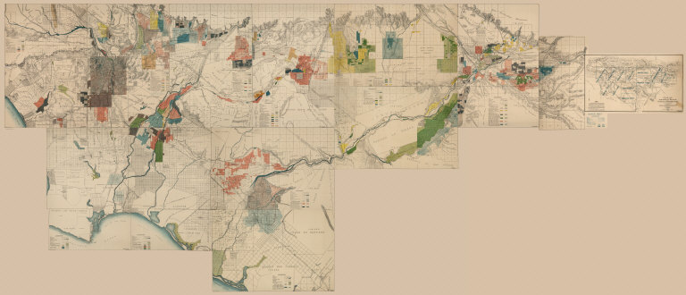
[Hall, Wm. Ham. (William Hammond), California Department of Engineering]
Full Title
(Composite of) California State Engineering Department. Detail Irrigation Map(s), Los Angeles and San Bernardino Counties, California. To Accompany Report on Irrigation and Water Supply. Wm. Ham. Hall, State Engineer, 1888. George Sandow, Draughtsman.Wm. Ham. Hall, State Engineer. Irrigation Data 1888. Scale 1 1/2 Inches to One Mile.
List No
5830.013
Note
In color.
1-17 of 17
|