|
Author
[Thomas, George Coupland, Thomas Bros.]
Full Title
San Francisco Bay Region. G.C.T. (to accompany) Thomas Bros. map of the city & county of San Francisco. Copyright by Geo. C. Thomas. Compiled and published by Tohmas Bros... Oakland 12, Calif. (Cover title) Thomas Bros. San Francisco info-guide and complete detailed colorful street map. Copyright 1945 by George Coupland Thomas.
List No
11147.004
Note
Uncolored map of San Francisco Bay Region. Showing highways, roads, cities, parks, etc.
Author
[Thomas, George Coupland, Thomas Bros.]
Full Title
Bay Counties. Geo. C.Thomas. (to accompany) Thomas Bros. map of the city & county of San Francisco. Copyright by Geo. C. Thomas. Compiled and published by Tohmas Bros... Oakland 12, Calif. (Cover title) Thomas Bros. San Francisco info-guide and complete detailed colorful street map. Copyright 1945 by George Coupland Thomas.
List No
11147.005
Note
Uncolored map of San Francisco Bay counties. Showing administrative divisions, cities and towns, roads, ect. Relief shown by hachures and spot heights.
Author
[Guyer, Terry, BioSpace]
Full Title
Biotech Bay
List No
15320.000
Author
[Parsons, Brinckerhoff, Hall and Macdonald, San Francisco Bay Area Rapid Transit Commission]
Full Title
Comprehensive Plan for Regional Rapid Transit.
List No
6344.009
Author
[Parsons, Brinckerhoff, Hall and Macdonald, San Francisco Bay Area Rapid Transit Commission]
Full Title
(Text Page) Bay Area Development (con't.) Organization of Urban Activities - 1954
List No
6344.014
Author
[Parsons, Brinckerhoff, Hall and Macdonald, San Francisco Bay Area Rapid Transit Commission]
Full Title
Land Characteristics - 1954.
List No
6344.019
Author
[Parsons, Brinckerhoff, Hall and Macdonald, San Francisco Bay Area Rapid Transit Commission]
Full Title
Land Development Policy. General Zoning Pattern - 1954
List No
6344.021
Author
[Parsons, Brinckerhoff, Hall and Macdonald, San Francisco Bay Area Rapid Transit Commission]
Full Title
Organization of Urban Activities - 1990
List No
6344.023
Author
[Parsons, Brinckerhoff, Hall and Macdonald, San Francisco Bay Area Rapid Transit Commission]
Full Title
Generalized Automobile Traffic Flow - 1954.
List No
6344.025
Author
[Parsons, Brinckerhoff, Hall and Macdonald, San Francisco Bay Area Rapid Transit Commission]
Full Title
Interurban Transit Traffic Flow. Generalized Transit Traffic Flow - 1954.
List No
6344.026
Author
[Parsons, Brinckerhoff, Hall and Macdonald, San Francisco Bay Area Rapid Transit Commission]
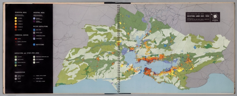
Full Title
Existing Land Use - 1954.
List No
6344.028
Note
Full color.
Author
[Parsons, Brinckerhoff, Hall and Macdonald, San Francisco Bay Area Rapid Transit Commission]
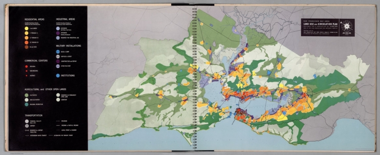
Full Title
Land Use and Circulation Plan.
List No
6344.029
Author
[Parsons, Brinckerhoff, Hall and Macdonald, San Francisco Bay Area Rapid Transit Commission]
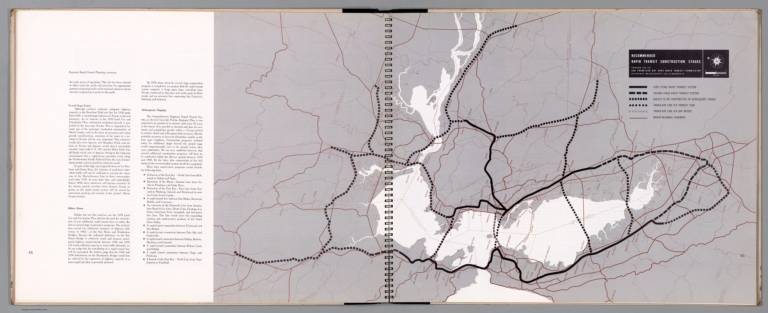
Full Title
Recommended Rapid Transit Construction Stages
List No
6344.032
Author
[Parsons, Brinckerhoff, Hall and Macdonald, San Francisco Bay Area Rapid Transit Commission]
Full Title
Existing Interurban Mass Transportation Systems - 1954.
List No
6344.033
Author
[Parsons, Brinckerhoff, Hall and Macdonald, San Francisco Bay Area Rapid Transit Commission]
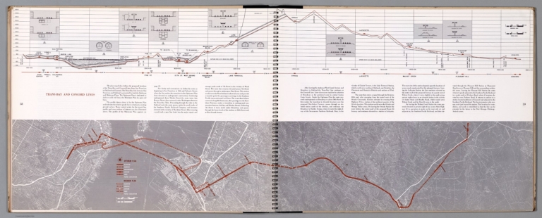
Full Title
The Minimum Plan (continued).
List No
6344.037
Author
[Parsons, Brinckerhoff, Hall and Macdonald, San Francisco Bay Area Rapid Transit Commission]
Full Title
The Minimum Plan (continued).
List No
6344.038
Author
[Parsons, Brinckerhoff, Hall and Macdonald, San Francisco Bay Area Rapid Transit Commission]
Full Title
The Minimum Plan (continued).
List No
6344.039
Author
[Parsons, Brinckerhoff, Hall and Macdonald, San Francisco Bay Area Rapid Transit Commission]
Full Title
The Minimum Plan (continued).
List No
6344.040
Author
[Parsons, Brinckerhoff, Hall and Macdonald, San Francisco Bay Area Rapid Transit Commission]
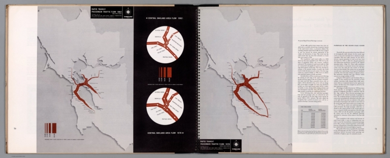
Full Title
Rapid Transit Passenger Traffic Flow - 1962.
List No
6344.041
Author
[Parsons, Brinckerhoff, Hall and Macdonald, San Francisco Bay Area Rapid Transit Commission]
Full Title
Recommended Fare Zones For First Stage System.
List No
6344.042
Author
[United States. Office of War Information, United States. Army. Western Defense Command, United States. Wartime Civil Control Administration]
Full Title
Japanese population : Western defense command area : 1940. Western Defense Command and Fourth Army, Wartime Civil Control Administration.
List No
14375.027
Note
Map of the western United States, featuring the Japanese population in the Western Defense Command Area in 1940. Shows political boundaries and the approximate number of Japanese Americans in each state, utilizing data visualization to illustrate population density. Includes a legend. With four inset maps: Seattle metropolitan area -- Portland metropolitan area -- San Francisco Bay Area -- Los Angeles metropolitan area. Black and white. Map is 14 x 12 cm, on sheet 23 x 15 cm. "Source: U. S. Bureau of the Census." Figure 6. Appears in Part IV : Evacuation - its operational technique, Chapter VIII : Development and execution of the evacuation plan.
Author
[United States. Office of War Information, United States. Army. Western Defense Command, United States. Wartime Civil Control Administration]
Full Title
Exclusion areas : Japanese evacuation program. Western Defense Command and Fourth Army, Wartime Civil Control Administration.
List No
14375.030
Note
Map of the western United States, featuring the exclusion areas during the evacuation of the Japanese population from the Pacific Coast. Shows political boundaries and the assembly and relocation centers. Includes a legend. With four inset maps: Seattle and vicinity -- Portland and vicinity -- San Francisco and vicinity -- Los Angeles and vicinity. Black and white. Map is 15 x 12 cm, on sheet 23 x 15 cm. Figure 9. Appears in Part IV : Evacuation - its operational technique, Chapter VIII : Development and execution of the evacuation plan.
Author
[United States. Office of War Information, United States. Army. Western Defense Command, United States. Wartime Civil Control Administration]
Full Title
Japanese evacuation program : Exclusion areas. Western Defense Command and Fourth Army, Wartime Civil Control Administration, Statistical Division.
List No
14375.090
Note
Map of the western United States, featuring the "exclusion areas" for Japanese Americans during World War II. Shows political boundaries, assembly and relocation centers, bodies of water, coastline and islands. Includes a legend and explanatory note. With four inset maps: Seattle and vicinity -- Portland and vicinity -- San Francisco and vicinity -- Los Angeles and vicinity -- Sacramento and vicinity. In color. Map is 32 x 32 cm, on fold-out sheet 45 x 36 cm. Figure 27. Appears in Part VI : Relocation of evacuees, Chapter XXII : Transfer of evacuees from assembly to relocation centers.
Author
[United States. Office of War Information, United States. Army. Western Defense Command, United States. Wartime Civil Control Administration]
Full Title
Japanese evacuation program : Assembly center destinations. Western Defense Command and Fourth Army, Wartime Civil Control Administration, Statistical Division.
List No
14375.091
Note
Map of the western United States, featuring the assembly center destinations for Japanese Americans during World War II. Shows political boundaries, assembly and relocation centers, bodies of water, coastline and islands. Includes a legend and explanatory note. With five inset maps: Seattle and vicinity -- Portland and vicinity -- San Francisco and vicinity -- Los Angeles and vicinity -- Sacramento and vicinity. In color. Map is 32 x 32 cm, on fold-out sheet 45 x 36 cm. Figure 27. Appears in Part VI : Relocation of evacuees, Chapter XXII : Transfer of evacuees from assembly to relocation centers.
Author
[United States. Office of War Information, United States. Army. Western Defense Command, United States. Wartime Civil Control Administration]
Full Title
Japanese evacuation program : Relocation center destinations. Western Defense Command and Fourth Army, Wartime Civil Control Administration, Statistical Division.
List No
14375.092
Note
Map of the western United States, featuring the relocation center destinations for Japanese Americans during World War II. Shows political boundaries, assembly and relocation centers, bodies of water, coastline and islands. Includes a legend and explanatory note. With five inset maps: Seattle and vicinity -- Portland and vicinity -- San Francisco and vicinity -- Los Angeles and vicinity -- Sacramento and vicinity. In color. Map is 32 x 32 cm, on fold-out sheet 45 x 36 cm. Figure 27. Appears in Part VI : Relocation of evacuees, Chapter XXII : Transfer of evacuees from assembly to relocation centers.
Author
[H.M. Gousha Company, Standard Oil Company of California]
Full Title
Map of San Francisco and vicinity prepared for Standard Oil Company of California. Copyright by the H.M. Gousha Company, Chicago-San Jose.
List No
15208.002
Note
Relief shown by shading and spot heights. Indexed. Includes mileage chart. Map is printed in full color and folds into self wrappers 23 x 10. Inset map of downtown San Francisco shows the newly completed Central Freeway. See our 3264.000 for the 1953 edition of this map that shows the freeway under construction.
Author
[Geological Survey (U.S.), Dolan, Robert, Bosserman, Kenton, Felder, Wilson]
Full Title
Coastal landforms / compiled by Robert Dolan, University of Virginia, assisted by Kenton Bosserman and Wilson Felder, 1967.
List No
14359.057
Note
Physical map representing the United States, featuring coastal landforms, as of 1967. Shows coastline configuration and composition, shoreline characteristics, political boundaries, topography, bodies of water, drainage, coastlines, islands and bathymetry. Relief shown with shading. Includes a legend, latitudinal and longitudinal lines, as well as a bar scale and scale statement. With six inset maps: 1. Sandy Hook to Cape Ann -- 2. Chesapeake Bay and vicinity -- 3. San Francisco Bay Area -- 4. Puget Sound and vicinity -- Principal islands of Hawaii -- Alaska. Presented with Albers Equal Area Projection. Colored lithograph. Map is 43 x 66 cm, on double sheet 49 x 71 cm. Appears in Special subject maps section, subsection Physical : Marine features.
Author
R. Crumb (Robert Dennis Crumb)
Full Title
Map to Eric’s Place in Muir Beach.
List No
15052.000
Note
Date estimated.
Author
Anonymous
Full Title
The look from the top of the Mark : still San Francisco;s most sectacular view. the Mark Hopkins, an Intercontinental Hotal.
List No
13638.000
Author
San Francisco Bay Area Rapid Transit District (Calif.)
Full Title
BART. Going places. (cover title) Sept. 1972-Sept. 1982 : A decade of service : report to owners.
List No
13645.002
Author
Mark Hopkins Hotel
Full Title
50 miles panoramic view of the San Francisco Bay Area from top of the Mark : The world’s most spectacular cocktail lounge towering high above historic Nob Hill.
List No
13592.002
Author
[Silicon Maps, Inc., Trestria, Bettius, Basil]
Full Title
Silicon Valley. Central Computers.
List No
10644.000
Author
Silicon Maps, Inc.
Full Title
Bioscience West Global Leaders in Drug Discovery and Development.
List No
10658.000
Author
Lamm, Warren
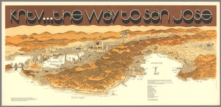
Full Title
KNTV ... The way to san Jose. Illustration and design by Warren Lamm.
List No
13466.000
Author
Blackwell, William
Full Title
The World centered on San Francisco Bay area : Global orientation chart . Map and text c1986, William Blackwell. Prepared by CartoGraphics, San Francisco. Text by Julia Cheever and William Blackwell. Azed Production, San Francisco.
List No
13209.000
Note
Color global orientation chart. Shows great circle distances from the Rotunda of the San Francisco City Hall, includes major world cities with time differences from Pacific Standard Time. Azimuthal equidistant projection.
Author
Federal Works Agency, Work Projects Administration
Full Title
(Composite map of) San Francisco Scale Model, Scale 1 inch 100 ft. Constructed by Federal Works Agency, Work Projects Administration. Sponsored by City Planning Commission. 1940.
List No
10261.001
Note
Composite of all pieces of the San Francisco Model. This model is a 42 by 38 foot detailed wooden replica of the city of San Francisco as it was in 1940 in 158 pieces at a scale of 1 inch to 100 feet. The pieces contain about 6,000 removable city blocks. The model was built by The Works Progress Administration in the late 1930s, under the New Deal. It was first displayed in sections in the Golden Gate International Exposition on Treasure Island in San Francisco Bay in 1939. In 1940-1942 it was displayed in San Francisco City Hall. The model was used as an urban planning tool by San Francisco city agencies and departments through the 1960's. In 1968, the downtown portion of the model became a research and planning tool in the Environmental Simulation Laboratory in the College of Environmental Design at UC Berkeley. The model has not been on public view, in its entirety, since 1942. UC Berkeley is the current owner of the model. The intent of the makers of the model was to have it updated as the city changed over time. The condition of the model is generally good except for the downtown and south of market portion which needs restoration - many blocks have been removed and lost, probably from the time it was used and updated as a planning tool. In 2018 and 2019 the model was cleaned and made available for public viewing both physically and digitally as part of the joint program of SFMOMA and the San Francisco Public Library called Public Knowledge: Take Part, with these participants: Artist Team: Bik Van der Pol; Project Manager: Stella Lochman; Project Director: Tomoko Kanamitsu; Curatorial Lead: Deena Chalabi. The model pieces were individually photographed by Beth LaBerge. David Rumsey created the large Composite image of the 158 pieces, as well as the image and metadata database of all the images, which he hosts. Visit the web site for Public Knowledge: Take Part at https://publicknowledge.sfmoma.org/take-part/
Author
Federal Works Agency, Work Projects Administration
Full Title
Map of the City and County of San Francisco. Key to the WPA Sectional Model. San Francisco City Planning Comm.
List No
10261.003
Note
The names of the model pieces and their boundaries are drawn on the map in black pen. The six pieces that fall below the southern boundary of the city are not shown - pieces AA4, AA5, Y3, Y4, Z5, and V7. The Yerba Buena Island piece and the Title piece are not shown.
Author
Federal Works Agency, Work Projects Administration
Full Title
San Francisco Scale Model AA1
List No
10261.004
Note
Geneva Avenue, baseball diamonds. Amazon Reservoir site.
Author
Federal Works Agency, Work Projects Administration
Full Title
San Francisco Scale Model AA2
List No
10261.005
Note
Visitacion Valley. Shows San Francisco San Mateo County border.
Author
Federal Works Agency, Work Projects Administration
Full Title
San Francisco Scale Model AA3
List No
10261.006
Note
Visitacion Valley area. Shows San Francisco San Mateo County border.
Author
[Sloat, Brian, Burrito Justice]
Full Title
San Francisco Archipelago, showing the 200 foot sea level rise. Map by Brian Sloat and Burrito Justice (copyright) 2012.
List No
8308.000
Note
High resolution topographic map of the San Francisco Archipelago, released by Northern California Coast Survey, showing the 200 foot sea level rise compared to the 2012 sea level datum, and shows what the city would like after a catastrophic disintegration of the Antarctic ice cap that caused sea levels to rise 200 feet, transforming San Francisco from a peninsula into an archipelago. Depth shown by isolines and gradient tints.
Author
Goddard, George H. (George Henry), 1817-1906
Full Title
Birds eye view of the city of San Francisco and surrounding country. Drawn by George H. Goddard. Lith. Britton & Rey, S.F. Entered according to act of Congress in the year 1868 by Snow & May in the ... U.S. District Court for the Northern District of California.
List No
5682.000
Note
Col. lithographic view looking east over ocean beach to the city, with the East Bay and Sierra; Golden Gate at the lower left. Unnumbered key in lower margin. A separate numbered key was published as "Key to Snow & Roos view ..." "This is the first of the 'run' of large bird's-eyes looking to the east" -- Baird. David Rumsey Collection copy framed.
Author
La Perouse, Jean-Francois de Galaup, comte de, 1741-1788
Full Title
Plan du Port de St. Francois, situe sur la cote de la Californie Septentrionale. La Pointe des Rois par 37059' de latitude nord et 124054' de longitude occidentale. Atlas du Voyage de la Perouse no. 33. (Au Depot General de la Marine en 1828)
List No
0233.027
Note
Engraved map. Relief shown by hachures; soundings in "brasses d'Espagne." Oriented with north toward upper left. "L. Aubert scripsit" replaced by "Prix deux francs." "No. 332."
Author
[Touring club italiano, Funk & Wagnalls Company.]
Full Title
Stati Uniti, United States of America, California, Nevada, Utah, Arizona. (with San Francisco, Oakland, Berkeley region). Propr. Artistico-letteraria del T.C.I. Ufficio cartografico del T.C.I. (1929)
List No
1012.075
Note
Color map. Relief shown by hachures and spot heights; depths by isolines. Inset map at 1:250,000 scale.
Author
Federal Works Agency, Work Projects Administration
Full Title
San Francisco Scale Model AA4
List No
10261.007
Note
Visitacion Valley area. Race track. and Agricultural Exhibit building or Cow Palace. Part of San Mateo County just south of San Francisco border. Shows San Francisco San Mateo County border. Not shown on Key Map.
Author
Federal Works Agency, Work Projects Administration
Full Title
San Francisco Scale Model AA5
List No
10261.008
Note
Southern Pacific shops and round house. Part of San Mateo County just south of San Francisco border. Shows San Francisco San Mateo County border. Not shown on Key Map.
Author
Federal Works Agency, Work Projects Administration
Full Title
San Francisco Scale Model B1
List No
10261.009
Note
Marina district.
Author
Federal Works Agency, Work Projects Administration
Full Title
San Francisco Scale Model B2
List No
10261.010
Note
Presidio. Palace of Fine Arts.
Author
Federal Works Agency, Work Projects Administration
Full Title
San Francisco Scale Model B3
List No
10261.011
Note
Presidio shoreline.
Author
Federal Works Agency, Work Projects Administration
Full Title
San Francisco Scale Model B4
List No
10261.012
Note
Crissy Field airport. Presidio.
|