|
REFINE
Browse All : Images of Saint Augustin (Fla.)
1-1 of 1
Author
[Blunt, Edmund M. (Edmund March), 1770-1862, Hooker, William]
Full Title
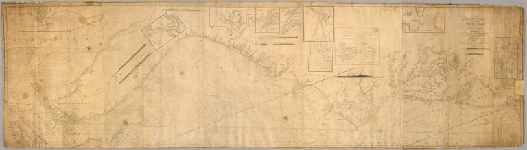
To the Marine Society of the city of New York; this chart, extending from lat. 40¦15' N. long: 72¦15' W. to Lat. 22¦35" N. long: 80¦25' W. is respectfully dedicated, by their obedient servant, Edmund M. Blunt, 1820 ... Plans engraved by Hooker, N. York.
List No
5003.001
Note
This early bluebacked chart published by Blunt and engraved by William Hooker covers the east coast of the United States from New York to Havana. It is very large, over eight feet long, and has numerous coastal views. Inset charts: Plan of Little Egg Harbour ... -- Sapello Bar & Sound ... -- A plan of the entrance into Winyaw Bay, George Town, S.C. -- Beaufort Harbor -- Ocracock Bar including Shell Castle -- Charleston Harbor -- The harbor at Port Royal -- The inlet of St. Mary's River -- Plan of the entrance & harbour of St. Augustin -- Entrance to the harbour of Havanna ... 1818. The 1st ed. was 1815, this being the 2nd "Improved" ed. according to the detailed catalog of Blunt and Hooker's charts and books on the verso. Blunt charts as early as 1820 are scarce. There may have been an additional "wing" sheet attached to the bottom sheet and showing the Bahama Banks, but not present in Rumsey Collection copy. Relief shown by hachures; depths by soundings. Printed on 6 sheets; Rumsey Collection copy mounted as 1 sheet, and has pencil annotations.
1-1 of 1
|