|
REFINE
Browse All : Images of Quebec (Quebec)
1-20 of 20
Author
Popple, Henry
Full Title
A Map of the British Empire in America with the French and Spanish Settlements adjacent thereto. by Henry Popple. (Sheet 4).
List No
2874.006
Note
Sheet four includes two city views - Quebec and New York. Both views have labeled points, which are explained on the legends to the right of each map. The "Grand Fishing Bank" is also shown and includes soundings. Uncolored.
Author
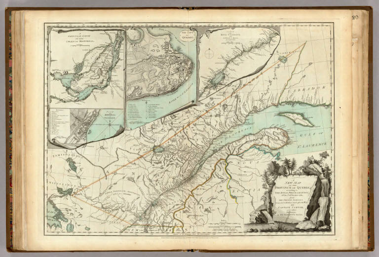
Jefferys, Thomas
Full Title
A New Map Of The Province of Quebec, according to The Royal Proclamation, of the 7th of October 1763. from The French Surveys Connected with those made after the War. By Captain Carver, and Other Officers, in His Majesty's Service. (with) four inset maps: A Particular Survey Of The Isles of Montreal; Plan of Montreal, or Villemarie; The City of Quebec; Course of the River St. Laurence, from la Valterie to Quebec on a Larger Scale. London. Printed for Robt. Sayer and John Bennett ... 16th February 1776.
List No
0346.021
Note
In outline color with the waterways in a blue wash. The cities are shown with labeled points of reference.
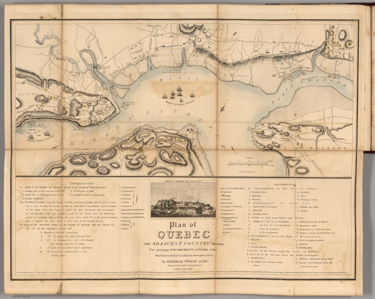
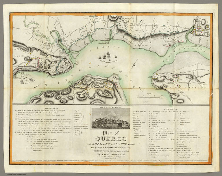
Author
Melish, John
Full Title
Plan of Quebec and Adjacent Country Shewing The principal Encampments & Works of the British & French Armies during the Siege by General Wolfe in 1759. Reduced from the M.S.S. Map of Capt. J.B. Glegg, by John Melish.
List No
0495.010
Note
Color map showing the encampments and works of the British and French armies during the siege of 1759. Included on the map are a view of Quebec from Point Levi and references to the map.
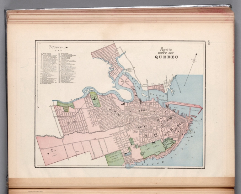
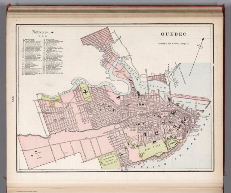
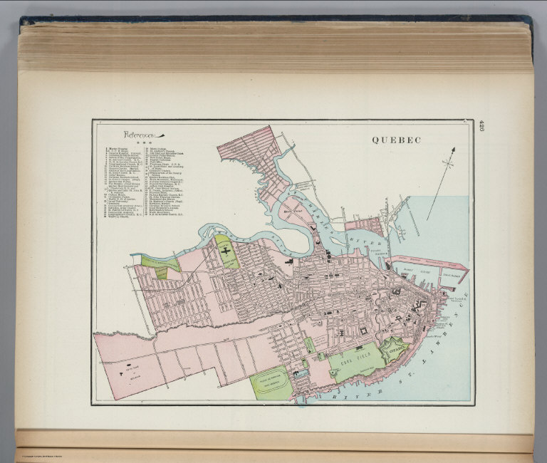
Author
Cram, George Franklin, 1841-1928
Full Title
Map of the city of Quebec.
List No
14372.239
Note
Map of Quebec, Canada. Shows political boundaries, railroads, streets, bridges, parks, topography, bodies of water, drainage, shorelines and islands. Relief shown with hachures. Includes compass rose with north oriented toward upper right. Map indexed to indicate place names. Colored lithograph. Map is 25 x 34 cm, on sheet 33 x 45 cm.
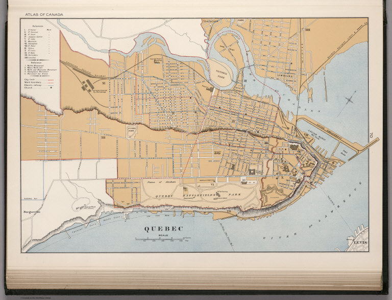
Author
[White, James, Canada. Department of Interior]
Full Title
Quebec. (on upper margins) Atlas of Canada, Plate No, 36. (to accompany) Department of the Interior, Canada ... 1906. (inset map) St. John.
List No
1645.056
Note
Color map. Shows Shows administrative boundaries, wards, tracts, block numbers, and railway system. Includes legend and reference to the wards. Relief shown by hachures. Depth shown in soundings.
Author
[Canada. Department of Interior, Chalifour, J.E.]
Full Title
Quebec. (on upper margin). Atlas of Canada. (to accompany) Department of the Interior Canada. Atlas Of Canada, 1915.
List No
1646.051
Note
Color map. Shows city limit, ward boundary, electric railways, roads and church. Includes reference.
Author
[Cram, George Franklin, Murray-Aaron, Eugene, 1852-1941.]
Full Title
Quebec. Published by George F. Cram, Chicago, Ill. (to accompany) Cram's atlas of the world, ancient and modern : new census edition -- indexed.
List No
1910.104
Note
Color map. Shows city blocks, roads, parks, etc. Includes references to hospitals, schools, churches, military establishments, etc.
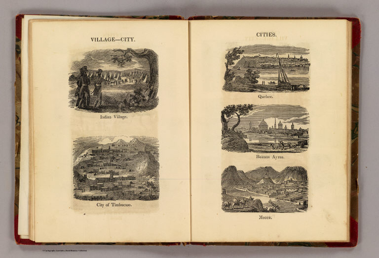
Full Title
Village--City. Indian village, city of Timbuctoo. Cities. Quebec, Buenos Ayres, Mecca. (Boston: Gray & Bowen ... 1831)
List No
2468.004
Note
Five uncolored engraved views on 2 pages.
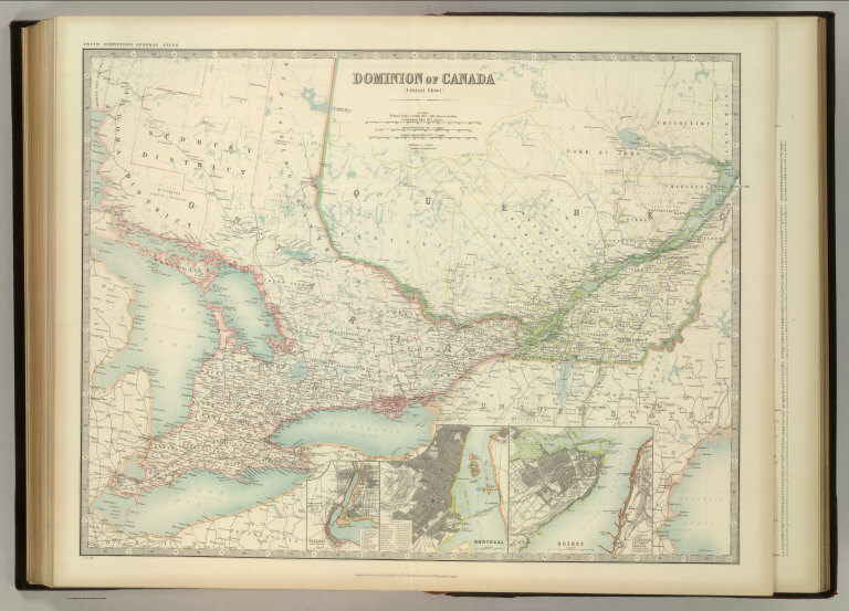
Author
Johnston, W. & A.K.
Full Title
Dominion of Canada (Central Sheet). (with) Niagara and Vicinity. (with) Montreal. (with) Quebec. Keith Johnston's General Atlas. Jan. 1912. Engraved, Printed, and Published by W. & A.K. Johnston, Limited, Edinburgh & London.
List No
2763.055
Note
Provinces and counties outlined in color. Relief shown by hachures. Three scales. Three insets.
Author
Melish, John
Full Title
Plan of Quebec and Adjacent Country Shewing The principal Encampments & Works of the British & French Armies during the Siege by General Wolfe in 1759. Reduced from the M.S.S. Map of Capt. J.B. Glegg, by John Melish.
List No
2788.008
Note
Color map showing the encampments and works of the British and French armies during the siege of 1759. Included on the map are a view of Quebec from Point Levi and references to the map.
Author
Cram, George Franklin
Full Title
Quebec.
List No
2809.071
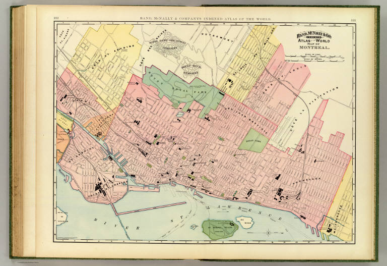
Author
Rand McNally and Company
Full Title
Rand, McNally & Co.'s indexed atlas of the world map of Montreal. Copyright, 1893, by Rand, McNally & Co. (Chicago, 1897)
List No
3565.062
Note
Col. map. Oriented with north toward right. Shows major buildings, parks, cemeteries, etc. Title in margin: Rand, McNally & Company's indexed atlas of the world.
Author
[Johnston, Alexander Keith, 1804-1871, Rogers, Henry Darwin]
Full Title
Quebec and its Environs (with) Montreal. Entered in Sta. Hall. London ... & according to an act of Congress ... 1857, by H.D. Rogers ... Massachusetts. London, John Murray, Albemarle Street, Edinburgh, W. & A.K. Johnston. Engraved by W. & A.K. Johnston, Edinburgh.
List No
3825.026
Note
Both cities shown in black and white with water in printed green color.
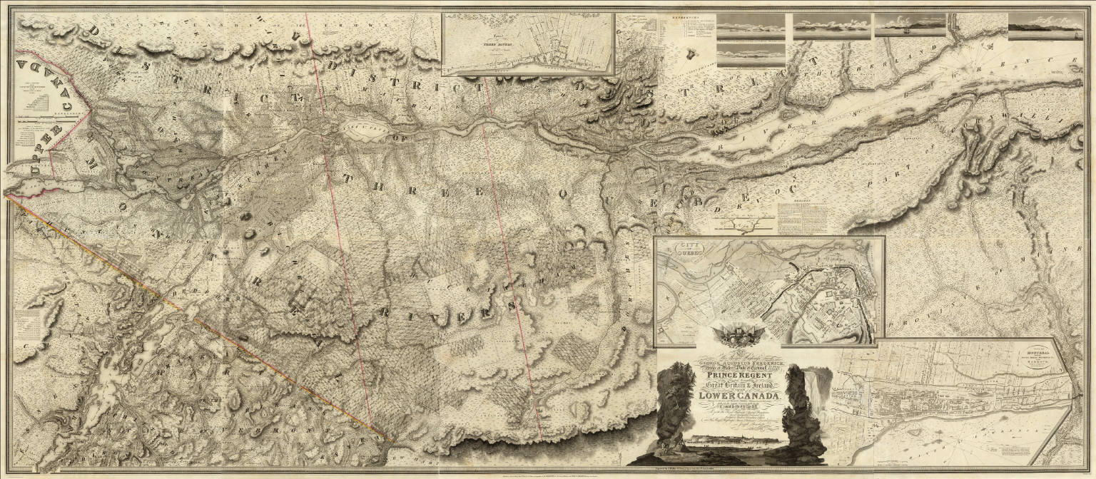
Author
[Bouchette, Joseph, Faden, William, 1750?-1836]
Full Title
(Composite of) To His Royal Highness George Augustus Frederick ... This Topographical map of the Province of Lower Canada, shewing its division into Districts, Counties, Seigniories, & Townships ... Is ... Most gratefully dedicated by ... Joseph Bouchette, His Majesty's Surveyor General of the Province & Lieutt. Colonel C.M. ... Published by W. Faden, Charing Cross, Augst. 12th. 1815. Engraved by J. Walker & Sons, 47 Bernard Street, Russell Square, London. J. Walker sculp. (with) Town of Three Rivers. (with) City of Quebec. (with) Town of Montreal ...
List No
4431.011
Note
Engraved map on 10 sheets. Boundaries outlined in color by hand. Includes 5 five views and three large inset maps of Montreal, Quebec, and Three Rivers. Relief shown by hachures; depths by soundings. Shows buildings in cities.
Author
[Bouchette, Joseph, Faden, William, 1750?-1836]
Full Title
(Composite of eastern sheets) To His Royal Highness George Augustus Frederick ... This Topographical map of the Province of Lower Canada, shewing its division into Districts, Counties, Seigniories, & Townships ... Is ... Most gratefully dedicated by ... Joseph Bouchette, His Majesty's Surveyor General of the Province & Lieutt. Colonel C.M. ... Published by W. Faden, Charing Cross, Augst. 12th. 1815. Engraved by J. Walker & Sons, 47 Bernard Street, Russell Square, London. J. Walker sculp. (with) Town of Three Rivers. (with) City of Quebec. (with) Town of Montreal ...
List No
4431.013
Note
Four easternmost sheets of 10-sheet engraved map. Includes views, and ornamental cartouche. Relief shown by hachures; depths by soundings. Shows buildings in cities.
Bouchette, Joseph; Faden, William, 1750?... This Topographical map of the Province o... 1815 4431.008 Related Author
[Bouchette, Joseph, Faden, William, 1750?-1836]
Full Title
To His Royal Highness George Augustus Frederick ... This Topographical map of the Province of Lower Canada, shewing its division into Districts, Counties, Seigniories, & Townships. Sheet) G-H (... Is ... Most gratefully dedicated by ... Joseph Bouchette, His Majesty's Surveyor General of the Province & Lieutt. Colonel C.M. ... (Published by W. Faden, Charing Cross, Augst. 12th. 1815). Engraved by J. Walker & Sons, 47 Bernard Street, Russell Square, London.
List No
4431.008
Note
One sheet of engraved map on 10 sheets. Relief shown by hachures. Shows buildings, parcel boundaries, etc. Includes part of inset maps "City of Quebec," and "Town of Montreal," continued on adjoining sheets. Illustrated cartouche.
Bouchette, Joseph; Faden, William, 1750?... (This Topographical map of the Province ... 1815 4431.010 Related Author
[Bouchette, Joseph, Faden, William, 1750?-1836]
Full Title
(To His Royal Highness George Augustus Frederick ... This Topographical map of the Province of Lower Canada, shewing its division into Districts, Counties, Seigniories, & Townships. Sheet) H (... Is ... Most gratefully dedicated by ... Joseph Bouchette, His Majesty's Surveyor General of the Province & Lieutt. Colonel C.M. .... Published by W. Faden, Charing Cross, Augst. 12th. 1815). J. Walker, sculp. (Engraved by J. Walker & Sons, 47 Bernard Street, Russell Square, London).
List No
4431.010
Note
Lower right sheet of engraved map on 10 sheets. Relief shown by hachures. Shows buildings, parcel boundaries, etc. Includes parts of inset map of Quebec, and of "Town of Montreal ..."
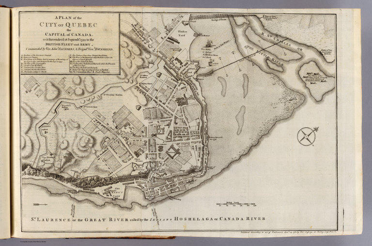
Author
Jefferys, Thomas
Full Title
A plan of the city of Quebec, the capital of Canada, as it surrendered 18 Septembr. 1759 to the British fleet and army commanded by Vice Adml. Saunders & Brigadr. Genl. Townshend. Published according to act of Parliament Janry. 15, 1760 by Thos. Jefferys at Charing Cross. Price 2 s.
List No
4796.002
Note
Engraved map. Relief shown by hachures. Shows buildings, fortifications, "St. Laurence or the Great River called by the Indians Hoshelaga or Canada River," etc. Oriented with north toward upper right.
Author
Popple, Henry
Full Title
A Map of the British Empire in America with the French and Spanish Settlements adjacent thereto. by Henry Popple. (Sheet 4).
List No
5810.011a
Note
Sheet four includes two city views - Quebec and New York. Both views have labeled points, which are explained on the legends to the right of each map. The "Grand Fishing Bank" is also shown and includes soundings. Colored.
Author
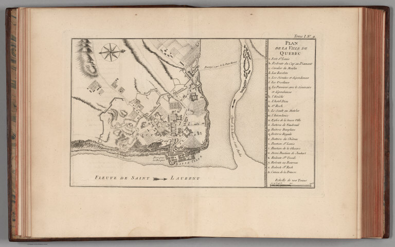
Bellin, Jacques Nicolas, 1703-1772
Full Title
Plan de la Ville de Quebec.
List No
6903.017
Note
Decorative title cartouche. Relief shown by hachures. Shows fortifications list.
1-20 of 20
|