|
REFINE
Browse All : Images of Portland (Or.)
1-17 of 17
Author
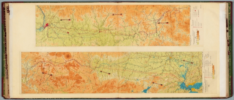
[Ford Motor Company, United States. Army. Air Corps]
Full Title
Air navigation map no. 41 (experimental) : San Francisco, Calif. to Medford, Ore. Compiled and reproduced by the Engineer Reproduction Plant, Corps of Engineers. Under the direction of the Airways Section, Office Chief of Air Corps. 1927. Engineer Reproduction Plant, U.S. Army, Washington Barracks, D.C. 6467. 1927. R1928. -- Air navigation map no. 42 (experimental) : Medford, Ore. to Vancouver, Wash. 1927. R-1928. Compiled and reproduced by the Engineer Reproduction Plant, Corps of Engineers. Under the direction of the Airways Section, Office Chief of Air Corps. 1926. Engineer Reproduction Plant, U.S. Army, Washington Barracks. 6468.
List No
14501.024
Note
Two aeronautical charts representing the areas from San Francisco, California. to Medford, Oregon, and from Medford, Oregon, to Vancouver, Washington. Features military, municipal, commercial, emergency, and seaplane landing fields, as well as beacon lights. Also shows political boundaries, roads, railways, cities, towns, topography, bodies of water, drainage, and coastlines. Relief shown with contour lines and color coding. Maps include latitudinal and longitudinal lines, legend, scale statements, and bar scales given in miles, as well as compass roses oriented toward top of sheet (with slight variation between the two maps). Color lithographs. Together, maps are 56 x 121 cm, on double sheet, 60 x 135 cm.
Author
[United States. Office of War Information, United States. Army. Western Defense Command, United States. Wartime Civil Control Administration]
Full Title
Japanese population : Western defense command area : 1940. Western Defense Command and Fourth Army, Wartime Civil Control Administration.
List No
14375.027
Note
Map of the western United States, featuring the Japanese population in the Western Defense Command Area in 1940. Shows political boundaries and the approximate number of Japanese Americans in each state, utilizing data visualization to illustrate population density. Includes a legend. With four inset maps: Seattle metropolitan area -- Portland metropolitan area -- San Francisco Bay Area -- Los Angeles metropolitan area. Black and white. Map is 14 x 12 cm, on sheet 23 x 15 cm. "Source: U. S. Bureau of the Census." Figure 6. Appears in Part IV : Evacuation - its operational technique, Chapter VIII : Development and execution of the evacuation plan.
Author
[United States. Office of War Information, United States. Army. Western Defense Command, United States. Wartime Civil Control Administration]
Full Title
Exclusion areas : Japanese evacuation program. Western Defense Command and Fourth Army, Wartime Civil Control Administration.
List No
14375.030
Note
Map of the western United States, featuring the exclusion areas during the evacuation of the Japanese population from the Pacific Coast. Shows political boundaries and the assembly and relocation centers. Includes a legend. With four inset maps: Seattle and vicinity -- Portland and vicinity -- San Francisco and vicinity -- Los Angeles and vicinity. Black and white. Map is 15 x 12 cm, on sheet 23 x 15 cm. Figure 9. Appears in Part IV : Evacuation - its operational technique, Chapter VIII : Development and execution of the evacuation plan.
Author
[United States. Office of War Information, United States. Army. Western Defense Command, United States. Wartime Civil Control Administration]
Full Title
Japanese evacuation program : Exclusion areas. Western Defense Command and Fourth Army, Wartime Civil Control Administration, Statistical Division.
List No
14375.090
Note
Map of the western United States, featuring the "exclusion areas" for Japanese Americans during World War II. Shows political boundaries, assembly and relocation centers, bodies of water, coastline and islands. Includes a legend and explanatory note. With four inset maps: Seattle and vicinity -- Portland and vicinity -- San Francisco and vicinity -- Los Angeles and vicinity -- Sacramento and vicinity. In color. Map is 32 x 32 cm, on fold-out sheet 45 x 36 cm. Figure 27. Appears in Part VI : Relocation of evacuees, Chapter XXII : Transfer of evacuees from assembly to relocation centers.
Author
[United States. Office of War Information, United States. Army. Western Defense Command, United States. Wartime Civil Control Administration]
Full Title
Japanese evacuation program : Assembly center destinations. Western Defense Command and Fourth Army, Wartime Civil Control Administration, Statistical Division.
List No
14375.091
Note
Map of the western United States, featuring the assembly center destinations for Japanese Americans during World War II. Shows political boundaries, assembly and relocation centers, bodies of water, coastline and islands. Includes a legend and explanatory note. With five inset maps: Seattle and vicinity -- Portland and vicinity -- San Francisco and vicinity -- Los Angeles and vicinity -- Sacramento and vicinity. In color. Map is 32 x 32 cm, on fold-out sheet 45 x 36 cm. Figure 27. Appears in Part VI : Relocation of evacuees, Chapter XXII : Transfer of evacuees from assembly to relocation centers.
Author
[United States. Office of War Information, United States. Army. Western Defense Command, United States. Wartime Civil Control Administration]
Full Title
Japanese evacuation program : Relocation center destinations. Western Defense Command and Fourth Army, Wartime Civil Control Administration, Statistical Division.
List No
14375.092
Note
Map of the western United States, featuring the relocation center destinations for Japanese Americans during World War II. Shows political boundaries, assembly and relocation centers, bodies of water, coastline and islands. Includes a legend and explanatory note. With five inset maps: Seattle and vicinity -- Portland and vicinity -- San Francisco and vicinity -- Los Angeles and vicinity -- Sacramento and vicinity. In color. Map is 32 x 32 cm, on fold-out sheet 45 x 36 cm. Figure 27. Appears in Part VI : Relocation of evacuees, Chapter XXII : Transfer of evacuees from assembly to relocation centers.
Author
Cram, George Franklin, 1841-1928
Full Title
Official map of the city of Portland, Oregon. Entered according to Act of Congress by R. A. Habersham, H. Nieberding, and H. L. Tarbet, in the year 1891. A. D. in the office of the Librarian of Congress at Washington, D. D.
List No
14372.234
Note
Map of Portland, Oregon. Shows political boundaries, railroads, streets, ferry lines, parks, bodies of water, drainage, shoreline and islands. Includes a legend and bar scale given in chains. Colored lithograph. Map is 46 x 33 cm, on double sheet 67 x 45 cm.
Author
United States. Office of War Information
Full Title
Location of assembly center : Portland.
List No
14375.038
Note
Map featuring the assembly center location in Portland, Oregon. Shows the vicinity's political boundaries, cities, railways, roads, topography, bodies of water and drainage. Relief shown with hachures and spot heights. Includes a legend, explanatory notes and bar scale given in miles. In color. Map is 14 x 11 cm, on sheet 23 x 15 cm. Figure 14-b. Appears in Part V : Assembly center operations, Chapter XIII : Assembly center location, construction and equipment.
Author
United States. Office of War Information
Full Title
Portland Assembly Center.
List No
14375.056
Note
Photograph featuring the Portland Assembly Center of Portland, Oregon. Shows the site with its surrounding buildings, roads, topography, bodies of water, drainage and vegetation. Bird's-eye view in black and white. View is 11 x 16 cm, on sheet 15 x 23 cm. Figure 16-g. Appears in Part V : Assembly center operations, Chapter XIII : Assembly center location, construction and equipment.
Author
[Cram, George Franklin, Murray-Aaron, Eugene, 1852-1941.]
Full Title
Official map of the City of Portland, Oregon. Published by George F. Cram, Chicago, Ill. (to accompany) Cram's atlas of the world, ancient and modern : new census edition -- indexed.
List No
1910.096
Note
Color map on 2 pages. Shows city blocks, roads, railroads, public buildings, parks, etc.
Full Title
Architectural solidity in Portland, Oregon. The Wells-Fargo Building. The Marquam Building. The Dekum Building. The Chamber of Commerce Building. (Published by Ellis A. Davis. Berkeley, Cal. Seattle. 1909)
List No
2134.040
Note
Four reproductions of photographs. "By courtesy of the Portland Journal."
Full Title
Prominent buildings of Portland, Oregon. The City Hall. The Worcester Building. The Armory Building. The Commercial Building. The Oregonian Building. (Published by Ellis A. Davis. Berkeley, Cal. Seattle. 1909)
List No
2134.041
Note
Five reproductions of photographs. "By courtesy of the Portland Journal."
Full Title
Some principal buildings of Portland, Oregon. The Custom House. The Library building. The Post Office. The Court House. (Published by Ellis A. Davis. Berkeley, Cal. Seattle. 1909)
List No
2134.042
Note
Four reproductions of photographs. "By courtesy of the Portland Journal."
Full Title
The Wells-Fargo Building, Portland, Oregon. (Published by Ellis A. Davis. Berkeley, Cal. Seattle. 1909)
List No
2134.044
Note
Reproduction of photograph.
Full Title
The Corbett Building, Portland, Oregon. (Published by Ellis A. Davis. Berkeley, Cal. Seattle. 1909)
List No
2134.045
Note
Reproductions of photograph. "By courtesy of the Portland Journal."
Full Title
Agricultural prosperity in Oregon. Beet culture and sugar making at La Grande. Industries of the prosperous La Grande country. The Oregon State Dairy Association, at Portland. (Published by Ellis A. Davis. Berkeley, Cal. Seattle. 1909)
List No
2134.046
Note
Nine reproductions of photographs. "By courtesy of the La Grande Commercial Club. By courtesy of the Portland Commercial Club."
Full Title
City of Portland, Oregon. (George F. Cram. 1909)
List No
2134.100
Note
Color map. Shows streets, railroads and street railroads.
1-17 of 17
|