|
Author
Schedel, Hartmann (1440-1514)
Full Title
Blat CCLXIII Poln (Poland) (Nuremberg Chronicle) Register DES BUCHS DER CRO=NICKEN und geschichten mit figure…
List No
15906.275
Note
Fascinating and largely fanciful image representing Poland, which has been described as probably the earliest printed map of Poland.
Author
Schedel, Hartmann (1440-1514)
Full Title
Blat CCLXXVIII Von polnischem land (Poland) Littaw (Lithuania) (Nuremberg Chronicle) Register DES BUCHS DER CRO=NICKEN und geschichten mit figure…
List No
15906.290
Author
[Ptolemy, Claudius, D'Angelo, Jacopo, Regiomontanus, Joannes, Pirckheimer, Willibald, Grueninger, Johann]
Full Title
(Tabula IV Europae )
List No
10891.016
Author
[Ptolemy, Claudius, D'Angelo, Jacopo, Regiomontanus, Joannes, Pirckheimer, Willibald, Grueninger, Johann]
Full Title
(Tabu. Moderna Hungariae, Poloniae, Russiae, Et Valachiae)
List No
10891.098
Author
[Munster, Sebastian, 1448–1552, Ptolemy, Claudius, Pirckheimer, Willibald, 1470-1530]
Full Title
Polonia et Ungaria XV Nova Tabula. (to accompany) Geographia universalis, vetus et nozva, complectens Claudii Ptolemaei Alexandrini enarrationis libros VIII ... Basileae apud Henricum Petrum Mense Martio anno M.D. XL (1540).
List No
11623.094
Note
Woodcut uncolored modern map of Poland and Hungary. Shows cities, towns, land marks, rivers, forests and mountains. Relief shown pictorially. Included notes.
Author
[Ptolemy, Claudius, Fries, Lorenz, Servetus, Michael]
Full Title
Evropae Tabvla quarta continct Germaniam magnam. (to accompany) Claudii Ptolemaei Alexandrini Geographicae enarrationis libri octo. Sed ad Graeca & prisca exemplaria a Michaele Villanouano secundo recogniti & locis innumeris denuo castigati. Prostant Lugduni Apud Hugonem a Porta. M.D.XLI. (1541).
List No
11325.012
Note
Engraved map of Germany, Poland and surroundings.
Author
[Ptolemy, Claudius, Fries, Lorenz, Servetus, Michael]
Full Title
Tabula noua Poloniae, Vngariae, & Russiae. (to accompany) Claudii Ptolemaei Alexandrini Geographicae enarrationis libri octo. Sed ad Graeca & prisca exemplaria a Michaele Villanouano secundo recogniti & locis innumeris denuo castigati. Prostant Lugduni Apud Hugonem a Porta. M.D.XLI. (1541).
List No
11325.067
Note
Engraved modern map of Russia, Poland and Hungary.
Author
[Ptolemy, Claudius, Gastaldi, Giacomo, Mattioli, Pietro Andrea, 1500-1577, Pedrezano, Giovanbattista]
Full Title
Tabula Europae IIII. (to accompany) Ptolemeo. La geografia di Claudio Ptolemeo alessandrino ... In Venetia, ... per Gioan. Baptista Pedrezano ... Anni x. M.D.XLVIII (1548).
List No
11479.027
Note
Engraved ancient map of Europe, Germany, Poland and neighboring countries. Shows cities, towns, rivers and mountains. Relief shown pictorially.
Author
[Ptolemy, Claudius, Gastaldi, Giacomo, Mattioli, Pietro Andrea, 1500-1577, Pedrezano, Giovanbattista]
Full Title
Prussia e Livonia nova. (to accompany) Ptolemeo. La geografia di Claudio Ptolemeo alessandrino ... In Venetia, ... per Gioan. Baptista Pedrezano ... Anni x. M.D.XLVIII (1548).
List No
11479.051
Note
Engraved modern map of Eastern Europe. Covers coasts of Poland & Livonia. Shows cities, towns, landmarks, rivers and mountains. Relief shown pictorially.
Author
[Ptolemy, Claudius, Gastaldi, Giacomo, Mattioli, Pietro Andrea, 1500-1577, Pedrezano, Giovanbattista]
Full Title
Polonia et Hungaria nova tabula. (to accompany) Ptolemeo. La geografia di Claudio Ptolemeo alessandrino ... In Venetia, ... per Gioan. Baptista Pedrezano ... Anni x. M.D.XLVIII (1548).
List No
11479.057
Note
Engraved modern map of Poland, Hungary and Lithuania. Shows cities, towns, rivers and mountains. Relief shown pictorially.
Author
[Ptolemy, Claudius, Ruscelli, Girolamo, Giuseppe Moletti, M.]
Full Title
Polonia et Hvngaria Nvova Tavola. Polonia, et Vngheria. Ottava tavola nvova d'Europa. (To accompany) La geografia di Claudio Tolomeo Alessandrino, nuouamente tradotta di Greco in Italiano, da Girolamo Ruscelli ... In Venetia, Appresso Vincenzo Valgrisi, M.D.LXI. (1561).
List No
11311.081
Note
Engraved map of Poland, Hungary, the Slovakia, the Czech Republic and parts of the region bounded by the Black Sea in the east. Relief shown pictorially.
Author
[Porebski, Stanislaw, Bertelli, Ferrando]
Full Title
Ducatus Oswieczimen et Zatoriensis descriptio
List No
15383.000
Author
Ortelius, Abraham, 1527-1598
Full Title
Thietmarsiae, Holsaticae Regionis Partis Typus Auctore Petro Boeckel. (with) Prussiae Descriptio ante aliquot annos ab Henrico Zellio edita, ab eoqz D. Ioanni Clur. ciui Gedanensi Ded: Cum privilegio..
List No
10000.053
Note
2 maps on 1 plate.
Author
Ortelius, Abraham, 1527-1598
Full Title
(Text Page) Poloniae Regnum 44.
List No
10000.096
Author
Ortelius, Abraham, 1527-1598
Full Title
Poloniae finitimarumque locorum descriptio Auctore Wenceslao Godreccio Polono. Cum Privilegio.
List No
10000.097
Author
Munster, Sebastian, 1448–1552
Full Title
Poloniae et Ungariae Tabula
List No
15058.035
Author
Munster, Sebastian, 1448–1552
Full Title
De Regno & tota regione Poloniae
List No
15058.210
Note
Two maps of Poland on facing pages.
Author
Mercator, Gerhard, 1512-1594
Full Title
Polonia Et Silesia. Per Gerardum Mercatorem Cum privilegio.
List No
10554.122
Author
[Ptolemy, Claudius, Ruscelli,Girolamo, Rosaccio, Giuseppe]
Full Title
Polonia et Hvngaria Nvova Tavola. Descrittione della polonia. Libro Primo. (to accompany) Geographia di Clavdio Tolomeo alessandrino, tradotta di Greco nell'idioma volgare Italiano da Girolamo Ruscelli ... In Venetia, MDXCIX (1599) Appresso gli heredi di M. Sessa.
List No
11299.048
Note
Engraved map of Poland, Hungary, the Slovakia, the Czech Republic and parts of the region bounded by the Black Sea in the east. Relief shown pictorially.
Author
Quad, Matthias, 1557-1613
Full Title
11. Germania.
List No
9690.030
Author
Quad, Matthias, 1557-1613
Full Title
16. Silesiae Ducatus accuratissime descriptus..
List No
9690.040
Author
Quad, Matthias, 1557-1613
Full Title
17. Prussiae Descriptio.
List No
9690.042
Author
Quad, Matthias, 1557-1613
Full Title
20. Misniae et Lusatiae tabula Descripta.
List No
9690.048
Author
Quad, Matthias, 1557-1613
Full Title
21. Mansfeldiae Comitatus desriptio.
List No
9690.050
Author
Quad, Matthias, 1557-1613
Full Title
71. Poloniae (Poland) ... desriptio.
List No
9690.150
Author
[Mercator, Gerhard, 1512-1594, Hondius, Jodocus, 1563-1612]
Full Title
Polonia Et Silesia. Per Gerardum Mercatorem Cum privilegio.
List No
10501.375
Author
[Mercator, Gerhard, 1512-1594, Hondius, Iodocus, 1563-1612]
Full Title
Brandenburg et Pomerania. (to accompany) Atlas minor Gerardi Mercatoris.
List No
11201.316
Note
Map of the provinces of Brandenburg and Pomerania, on the Baltic. Relief shown pictorially.
Author
[Mercator, Gerhard, 1512-1594, Hondius, Iodocus, 1563-1612]
Full Title
Polonia et Silesia. (to accompany) Atlas minor Gerardi Mercatoris.
List No
11201.331
Note
Map of present-day Poland and a portion of the Czech Republic. Relief shown pictorially.
Author
[Ortelius, Abraham, 1527-1598, Vrients, Jan Baptista]
Full Title
Poloniae, Lithuaniaeq. Descriptio. Auctore Wenceslao Godreccio; et correctore Andrea Pograbio Pilsnensi. Cum privilegio Imp. Regi�� etc. decennali.
List No
10001.288
Author
[Ortelius, Abraham, 1527-1598, Vrients, Jan Baptista]
Full Title
Prussiae Vera Descriptio. Per Gaspar. Henneberg. Erlichens
List No
10001.290
Author
[Ortelius, Abraham, 1527-1598, Vrients, Jan Baptista]
Full Title
Pomeraniae, Wandalicae Regionis, Typ. Privilegio. Livoniae Nova Descriptio, Joanne Portantio auctore. Ducatus Oswieczensis, Et Zatoriensis, Descriptio.
List No
10001.292
Note
3 maps on 1 plate. Scale is given in order of maps listed.
Author
[Blaeu, Willem Janszoon, 1571-1638, Strubicz, Maciej, about 1530-1604, Gerritsz., Hessel, approximately 1581-1632]
Full Title
Magni Dvcatvs Lithvaniae, Caeterarvmqve Regionvm Illi Adiacentivm Exacta Descriptio Illss.mi. ac Excellss.mi. Pricipis et Dni. D. Nicolai Christophori Radziwil. D.G. Olijcæ ac in Nieswies Ducis, S. Rom. Imperii Principis in Szylowiec ac Mir Comitis et S. Sepulchri Hierosolimitani Militis &c. Opera cura et impensis facta ac in lucem edita / Sculptum apud Heselum Gerardum.
List No
10151.023
Note
1 map : copperplate engraving on 4 sheets. Title at the top of the map, in a shield-shaped cartouche decorated with hanging fruit. Key of the different types of settlement in the bottom left, in a cartouche surmounted with the arms of the Duchy of Lithuania (the Vytis). Below, issuing from the bottom of the signature, is Blaeu's signature, which is flanked by two putti. Scale bars at the bottom, on a thick banner entwined around a large caliper. This sheet was the product of a cartographic endeavour that began in the mid-1580s, when Prince Nicolas Christophe Radziwill commissioned a survey of the Duchy of Lithuania from Maciej Strubicz, cartographer to the recently deceased King Stephen Báthory. Surviving correspondence suggests that Radziwill had intended to publish the resulting map as early as the 1590s, and while it has been speculated that a lost print appeared sometime before 1604, Blaeu’s is the earliest engraved version of the map to have survived. In its original state of 1613 it was accompanied by a Latin text below the map, two sectional studies of the Dniepr river, and a further Latin address to the reader, presented in a cartouche held by putti (for a copy of this state see Maps 9.Tab.15.). For some reason this address does not mention Strubicz, only Tomasz Makowski, who has often been mistaken for the cartographer, but was probably the author and/or courier of the drawing which was brought to Amsterdam for Gerritsz to engrave. After the initial run the plates remained in Blaeu’s stock. In 1631 the map was revised for publication in atlases, firstly by removing the Latin text and eventually the supplementary plans of the Dniepr. The reduced sheet remained in use for several decades in the atlases of Willem and his son Joan, who probably issued the impression used in the Klencke Atlas.
Author
[Lubin, Eilhard (1565-1621), Geelkercken, Nicolaes van]
Full Title
(Composite map) Nova illustrissimi principatus Pomeraniae descriptio cum adjuncta Principum genealogia et Principum veris et potiorum Urbium imaginibus et Nobilium insignibus. N. Geilkerckius sculpsit. [With] Pomeraniae et rerum in ea memorabilium brevis descriptio E. Lubini.
List No
11511.013
Note
Composite map of Pomerania, sheets 1-12. Large and impressive outline colored copperplate engraving map of Pomerania on 12 sheets, 42x54 or smaller, by Eilhard Lubin, Professor at the University of Rostock. In 1610 he was asked by Philipp II, the Duke of Pomerania to create a large scale map of the geography and history of the duchy. In 1612 map was completed, it was decorated with 49 town views, and coat of arms of the noble families. In 1618 the Dutch engraver Nicolas van Geelkercken, engraved the copperplates in Amsterdam, and a small number of sheets were printed. The plates disappeared in the thirty years war and were rediscovered by the historian Johann Carl Conard Oelrichs in 1758. The map shows 49 town views on the border, the family tree of the house of Griffins, dukes of Pomerania, with 157 names and small portraits, a small family tree of the house of Rugen, 5 large portraits of living dukes of different parts of Pomerania, and on the lower middle left sheet probably the portrait of Lubin himself. The map shows towns and villages, landmarks, churches, forest, rivers and mountains. Relief is shown pictorially. Lubin's Pomerania remained the most accurate map of the region from its inception in 1618 until the Prussian topographical survey of the eighteenth century. The map is extraordinary in the way that it combines the "mapping" of the history of the ruling families with the mapping of the topography of Pomerania.
Author
[Lubin, Eilhard (1565-1621), Geelkercken, Nicolaes van]
Full Title
Nova illustrissimi principatus Pomeraniae descriptio cum adjuncta Principum genealogia et Principum veris et potiorum Urbium imaginibus et Nobilium insignibus. N. Geilkerckius sculpsit. [With] Pomeraniae et rerum in ea memorabilium brevis descriptio E. Lubini.
List No
11511.001
Note
Large and impressive outline colored copperplate engraving map of Pomerania on 12 sheets, 42x54 or smaller, by Eilhard Lubin, Professor at the University of Rostock. In 1610 he was asked by Philipp II, the Duke of Pomerania to create a large scale map of the geography and history of the duchy. In 1612 map was completed, it was decorated with 49 town views, and coat of arms of the noble families. In 1618 the Dutch engraver Nicolas van Geelkercken, engraved the copperplates in Amsterdam, and a small number of sheets were printed. The plates disappeared in the thirty years war and were rediscovered by the historian Johann Carl Conard Oelrichs in 1758. The map shows 49 town views on the border, the family tree of the house of Griffins, dukes of Pomerania, with 157 names and small portraits, a small family tree of the house of Rugen, 5 large portraits of living dukes of different parts of Pomerania, and on the lower middle left sheet probably the portrait of Lubin himself. The map shows towns and villages, landmarks, churches, forest, rivers and mountains. Relief is shown pictorially. Lubin's Pomerania remained the most accurate map of the region from its inception in 1618 until the Prussian topographical survey of the eighteenth century. The map is extraordinary in the way that it combines the "mapping" of the history of the ruling families with the mapping of the topography of Pomerania.
Author
[Lubin, Eilhard (1565-1621), Geelkercken, Nicolaes van]
Full Title
Nova illustrissimi principatus Pomeraniae descriptio cum adjuncta Principum genealogia et Principum veris et potiorum Urbium imaginibus et Nobilium insignibus. N. Geilkerckius sculpsit. [With] Pomeraniae et rerum in ea memorabilium brevis descriptio E. Lubini.
List No
11511.002
Note
Large and impressive outline colored copperplate engraving map of Pomerania on 12 sheets, 42x54 or smaller, by Eilhard Lubin, Professor at the University of Rostock. In 1610 he was asked by Philipp II, the Duke of Pomerania to create a large scale map of the geography and history of the duchy. In 1612 map was completed, it was decorated with 49 town views, and coat of arms of the noble families. In 1618 the Dutch engraver Nicolas van Geelkercken, engraved the copperplates in Amsterdam, and a small number of sheets were printed. The plates disappeared in the thirty years war and were rediscovered by the historian Johann Carl Conard Oelrichs in 1758. The map shows 49 town views on the border, the family tree of the house of Griffins, dukes of Pomerania, with 157 names and small portraits, a small family tree of the house of Rugen, 5 large portraits of living dukes of different parts of Pomerania, and on the lower middle left sheet probably the portrait of Lubin himself. The map shows towns and villages, landmarks, churches, forest, rivers and mountains. Relief is shown pictorially. Lubin's Pomerania remained the most accurate map of the region from its inception in 1618 until the Prussian topographical survey of the eighteenth century. The map is extraordinary in the way that it combines the "mapping" of the history of the ruling families with the mapping of the topography of Pomerania.
Author
[Lubin, Eilhard (1565-1621), Geelkercken, Nicolaes van]
Full Title
Nova illustrissimi principatus Pomeraniae descriptio cum adjuncta Principum genealogia et Principum veris et potiorum Urbium imaginibus et Nobilium insignibus. N. Geilkerckius sculpsit. [With] Pomeraniae et rerum in ea memorabilium brevis descriptio E. Lubini.
List No
11511.003
Note
Large and impressive outline colored copperplate engraving map of Pomerania on 12 sheets, 42x54 or smaller, by Eilhard Lubin, Professor at the University of Rostock. In 1610 he was asked by Philipp II, the Duke of Pomerania to create a large scale map of the geography and history of the duchy. In 1612 map was completed, it was decorated with 49 town views, and coat of arms of the noble families. In 1618 the Dutch engraver Nicolas van Geelkercken, engraved the copperplates in Amsterdam, and a small number of sheets were printed. The plates disappeared in the thirty years war and were rediscovered by the historian Johann Carl Conard Oelrichs in 1758. The map shows 49 town views on the border, the family tree of the house of Griffins, dukes of Pomerania, with 157 names and small portraits, a small family tree of the house of Rugen, 5 large portraits of living dukes of different parts of Pomerania, and on the lower middle left sheet probably the portrait of Lubin himself. The map shows towns and villages, landmarks, churches, forest, rivers and mountains. Relief is shown pictorially. Lubin's Pomerania remained the most accurate map of the region from its inception in 1618 until the Prussian topographical survey of the eighteenth century. The map is extraordinary in the way that it combines the "mapping" of the history of the ruling families with the mapping of the topography of Pomerania.
Author
[Lubin, Eilhard (1565-1621), Geelkercken, Nicolaes van]
Full Title
Nova illustrissimi principatus Pomeraniae descriptio cum adjuncta Principum genealogia et Principum veris et potiorum Urbium imaginibus et Nobilium insignibus. N. Geilkerckius sculpsit. [With] Pomeraniae et rerum in ea memorabilium brevis descriptio E. Lubini.
List No
11511.004
Note
Large and impressive outline colored copperplate engraving map of Pomerania on 12 sheets, 42x54 or smaller, by Eilhard Lubin, Professor at the University of Rostock. In 1610 he was asked by Philipp II, the Duke of Pomerania to create a large scale map of the geography and history of the duchy. In 1612 map was completed, it was decorated with 49 town views, and coat of arms of the noble families. In 1618 the Dutch engraver Nicolas van Geelkercken, engraved the copperplates in Amsterdam, and a small number of sheets were printed. The plates disappeared in the thirty years war and were rediscovered by the historian Johann Carl Conard Oelrichs in 1758. The map shows 49 town views on the border, the family tree of the house of Griffins, dukes of Pomerania, with 157 names and small portraits, a small family tree of the house of Rugen, 5 large portraits of living dukes of different parts of Pomerania, and on the lower middle left sheet probably the portrait of Lubin himself. The map shows towns and villages, landmarks, churches, forest, rivers and mountains. Relief is shown pictorially. Lubin's Pomerania remained the most accurate map of the region from its inception in 1618 until the Prussian topographical survey of the eighteenth century. The map is extraordinary in the way that it combines the "mapping" of the history of the ruling families with the mapping of the topography of Pomerania.
Author
[Lubin, Eilhard (1565-1621), Geelkercken, Nicolaes van]
Full Title
Nova illustrissimi principatus Pomeraniae descriptio cum adjuncta Principum genealogia et Principum veris et potiorum Urbium imaginibus et Nobilium insignibus. N. Geilkerckius sculpsit. [With] Pomeraniae et rerum in ea memorabilium brevis descriptio E. Lubini.
List No
11511.005
Note
Large and impressive outline colored copperplate engraving map of Pomerania on 12 sheets, 42x54 or smaller, by Eilhard Lubin, Professor at the University of Rostock. In 1610 he was asked by Philipp II, the Duke of Pomerania to create a large scale map of the geography and history of the duchy. In 1612 map was completed, it was decorated with 49 town views, and coat of arms of the noble families. In 1618 the Dutch engraver Nicolas van Geelkercken, engraved the copperplates in Amsterdam, and a small number of sheets were printed. The plates disappeared in the thirty years war and were rediscovered by the historian Johann Carl Conard Oelrichs in 1758. The map shows 49 town views on the border, the family tree of the house of Griffins, dukes of Pomerania, with 157 names and small portraits, a small family tree of the house of Rugen, 5 large portraits of living dukes of different parts of Pomerania, and on the lower middle left sheet probably the portrait of Lubin himself. The map shows towns and villages, landmarks, churches, forest, rivers and mountains. Relief is shown pictorially. Lubin's Pomerania remained the most accurate map of the region from its inception in 1618 until the Prussian topographical survey of the eighteenth century. The map is extraordinary in the way that it combines the "mapping" of the history of the ruling families with the mapping of the topography of Pomerania.
Author
[Lubin, Eilhard (1565-1621), Geelkercken, Nicolaes van]
Full Title
Nova illustrissimi principatus Pomeraniae descriptio cum adjuncta Principum genealogia et Principum veris et potiorum Urbium imaginibus et Nobilium insignibus. N. Geilkerckius sculpsit. [With] Pomeraniae et rerum in ea memorabilium brevis descriptio E. Lubini.
List No
11511.006
Note
Large and impressive outline colored copperplate engraving map of Pomerania on 12 sheets, 42x54 or smaller, by Eilhard Lubin, Professor at the University of Rostock. In 1610 he was asked by Philipp II, the Duke of Pomerania to create a large scale map of the geography and history of the duchy. In 1612 map was completed, it was decorated with 49 town views, and coat of arms of the noble families. In 1618 the Dutch engraver Nicolas van Geelkercken, engraved the copperplates in Amsterdam, and a small number of sheets were printed. The plates disappeared in the thirty years war and were rediscovered by the historian Johann Carl Conard Oelrichs in 1758. The map shows 49 town views on the border, the family tree of the house of Griffins, dukes of Pomerania, with 157 names and small portraits, a small family tree of the house of Rugen, 5 large portraits of living dukes of different parts of Pomerania, and on the lower middle left sheet probably the portrait of Lubin himself. The map shows towns and villages, landmarks, churches, forest, rivers and mountains. Relief is shown pictorially. Lubin's Pomerania remained the most accurate map of the region from its inception in 1618 until the Prussian topographical survey of the eighteenth century. The map is extraordinary in the way that it combines the "mapping" of the history of the ruling families with the mapping of the topography of Pomerania.
Author
[Lubin, Eilhard (1565-1621), Geelkercken, Nicolaes van]
Full Title
Nova illustrissimi principatus Pomeraniae descriptio cum adjuncta Principum genealogia et Principum veris et potiorum Urbium imaginibus et Nobilium insignibus. N. Geilkerckius sculpsit. [With] Pomeraniae et rerum in ea memorabilium brevis descriptio E. Lubini.
List No
11511.007
Note
Large and impressive outline colored copperplate engraving map of Pomerania on 12 sheets, 42x54 or smaller, by Eilhard Lubin, Professor at the University of Rostock. In 1610 he was asked by Philipp II, the Duke of Pomerania to create a large scale map of the geography and history of the duchy. In 1612 map was completed, it was decorated with 49 town views, and coat of arms of the noble families. In 1618 the Dutch engraver Nicolas van Geelkercken, engraved the copperplates in Amsterdam, and a small number of sheets were printed. The plates disappeared in the thirty years war and were rediscovered by the historian Johann Carl Conard Oelrichs in 1758. The map shows 49 town views on the border, the family tree of the house of Griffins, dukes of Pomerania, with 157 names and small portraits, a small family tree of the house of Rugen, 5 large portraits of living dukes of different parts of Pomerania, and on the lower middle left sheet probably the portrait of Lubin himself. The map shows towns and villages, landmarks, churches, forest, rivers and mountains. Relief is shown pictorially. Lubin's Pomerania remained the most accurate map of the region from its inception in 1618 until the Prussian topographical survey of the eighteenth century. The map is extraordinary in the way that it combines the "mapping" of the history of the ruling families with the mapping of the topography of Pomerania.
Author
[Lubin, Eilhard (1565-1621), Geelkercken, Nicolaes van]
Full Title
Nova illustrissimi principatus Pomeraniae descriptio cum adjuncta Principum genealogia et Principum veris et potiorum Urbium imaginibus et Nobilium insignibus. N. Geilkerckius sculpsit. [With] Pomeraniae et rerum in ea memorabilium brevis descriptio E. Lubini.
List No
11511.008
Note
Large and impressive outline colored copperplate engraving map of Pomerania on 12 sheets, 42x54 or smaller, by Eilhard Lubin, Professor at the University of Rostock. In 1610 he was asked by Philipp II, the Duke of Pomerania to create a large scale map of the geography and history of the duchy. In 1612 map was completed, it was decorated with 49 town views, and coat of arms of the noble families. In 1618 the Dutch engraver Nicolas van Geelkercken, engraved the copperplates in Amsterdam, and a small number of sheets were printed. The plates disappeared in the thirty years war and were rediscovered by the historian Johann Carl Conard Oelrichs in 1758. The map shows 49 town views on the border, the family tree of the house of Griffins, dukes of Pomerania, with 157 names and small portraits, a small family tree of the house of Rugen, 5 large portraits of living dukes of different parts of Pomerania, and on the lower middle left sheet probably the portrait of Lubin himself. The map shows towns and villages, landmarks, churches, forest, rivers and mountains. Relief is shown pictorially. Lubin's Pomerania remained the most accurate map of the region from its inception in 1618 until the Prussian topographical survey of the eighteenth century. The map is extraordinary in the way that it combines the "mapping" of the history of the ruling families with the mapping of the topography of Pomerania.
Author
[Lubin, Eilhard (1565-1621), Geelkercken, Nicolaes van]
Full Title
Nova illustrissimi principatus Pomeraniae descriptio cum adjuncta Principum genealogia et Principum veris et potiorum Urbium imaginibus et Nobilium insignibus. N. Geilkerckius sculpsit. [With] Pomeraniae et rerum in ea memorabilium brevis descriptio E. Lubini.
List No
11511.009
Note
Large and impressive outline colored copperplate engraving map of Pomerania on 12 sheets, 42x54 or smaller, by Eilhard Lubin, Professor at the University of Rostock. In 1610 he was asked by Philipp II, the Duke of Pomerania to create a large scale map of the geography and history of the duchy. In 1612 map was completed, it was decorated with 49 town views, and coat of arms of the noble families. In 1618 the Dutch engraver Nicolas van Geelkercken, engraved the copperplates in Amsterdam, and a small number of sheets were printed. The plates disappeared in the thirty years war and were rediscovered by the historian Johann Carl Conard Oelrichs in 1758. The map shows 49 town views on the border, the family tree of the house of Griffins, dukes of Pomerania, with 157 names and small portraits, a small family tree of the house of Rugen, 5 large portraits of living dukes of different parts of Pomerania, and on the lower middle left sheet probably the portrait of Lubin himself. The map shows towns and villages, landmarks, churches, forest, rivers and mountains. Relief is shown pictorially. Lubin's Pomerania remained the most accurate map of the region from its inception in 1618 until the Prussian topographical survey of the eighteenth century. The map is extraordinary in the way that it combines the "mapping" of the history of the ruling families with the mapping of the topography of Pomerania.
Author
[Lubin, Eilhard (1565-1621), Geelkercken, Nicolaes van]
Full Title
Nova illustrissimi principatus Pomeraniae descriptio cum adjuncta Principum genealogia et Principum veris et potiorum Urbium imaginibus et Nobilium insignibus. N. Geilkerckius sculpsit. [With] Pomeraniae et rerum in ea memorabilium brevis descriptio E. Lubini.
List No
11511.010
Note
Large and impressive outline colored copperplate engraving map of Pomerania on 12 sheets, 42x54 or smaller, by Eilhard Lubin, Professor at the University of Rostock. In 1610 he was asked by Philipp II, the Duke of Pomerania to create a large scale map of the geography and history of the duchy. In 1612 map was completed, it was decorated with 49 town views, and coat of arms of the noble families. In 1618 the Dutch engraver Nicolas van Geelkercken, engraved the copperplates in Amsterdam, and a small number of sheets were printed. The plates disappeared in the thirty years war and were rediscovered by the historian Johann Carl Conard Oelrichs in 1758. The map shows 49 town views on the border, the family tree of the house of Griffins, dukes of Pomerania, with 157 names and small portraits, a small family tree of the house of Rugen, 5 large portraits of living dukes of different parts of Pomerania, and on the lower middle left sheet probably the portrait of Lubin himself. The map shows towns and villages, landmarks, churches, forest, rivers and mountains. Relief is shown pictorially. Lubin's Pomerania remained the most accurate map of the region from its inception in 1618 until the Prussian topographical survey of the eighteenth century. The map is extraordinary in the way that it combines the "mapping" of the history of the ruling families with the mapping of the topography of Pomerania.
Author
[Lubin, Eilhard (1565-1621), Geelkercken, Nicolaes van]
Full Title
Nova illustrissimi principatus Pomeraniae descriptio cum adjuncta Principum genealogia et Principum veris et potiorum Urbium imaginibus et Nobilium insignibus. N. Geilkerckius sculpsit. [With] Pomeraniae et rerum in ea memorabilium brevis descriptio E. Lubini.
List No
11511.011
Note
Large and impressive outline colored copperplate engraving map of Pomerania on 12 sheets, 42x54 or smaller, by Eilhard Lubin, Professor at the University of Rostock. In 1610 he was asked by Philipp II, the Duke of Pomerania to create a large scale map of the geography and history of the duchy. In 1612 map was completed, it was decorated with 49 town views, and coat of arms of the noble families. In 1618 the Dutch engraver Nicolas van Geelkercken, engraved the copperplates in Amsterdam, and a small number of sheets were printed. The plates disappeared in the thirty years war and were rediscovered by the historian Johann Carl Conard Oelrichs in 1758. The map shows 49 town views on the border, the family tree of the house of Griffins, dukes of Pomerania, with 157 names and small portraits, a small family tree of the house of Rugen, 5 large portraits of living dukes of different parts of Pomerania, and on the lower middle left sheet probably the portrait of Lubin himself. The map shows towns and villages, landmarks, churches, forest, rivers and mountains. Relief is shown pictorially. Lubin's Pomerania remained the most accurate map of the region from its inception in 1618 until the Prussian topographical survey of the eighteenth century. The map is extraordinary in the way that it combines the "mapping" of the history of the ruling families with the mapping of the topography of Pomerania.
Author
[Lubin, Eilhard (1565-1621), Geelkercken, Nicolaes van]
Full Title
Nova illustrissimi principatus Pomeraniae descriptio cum adjuncta Principum genealogia et Principum veris et potiorum Urbium imaginibus et Nobilium insignibus. N. Geilkerckius sculpsit. [With] Pomeraniae et rerum in ea memorabilium brevis descriptio E. Lubini.
List No
11511.012
Note
Large and impressive outline colored copperplate engraving map of Pomerania on 12 sheets, 42x54 or smaller, by Eilhard Lubin, Professor at the University of Rostock. In 1610 he was asked by Philipp II, the Duke of Pomerania to create a large scale map of the geography and history of the duchy. In 1612 map was completed, it was decorated with 49 town views, and coat of arms of the noble families. In 1618 the Dutch engraver Nicolas van Geelkercken, engraved the copperplates in Amsterdam, and a small number of sheets were printed. The plates disappeared in the thirty years war and were rediscovered by the historian Johann Carl Conard Oelrichs in 1758. The map shows 49 town views on the border, the family tree of the house of Griffins, dukes of Pomerania, with 157 names and small portraits, a small family tree of the house of Rugen, 5 large portraits of living dukes of different parts of Pomerania, and on the lower middle left sheet probably the portrait of Lubin himself. The map shows towns and villages, landmarks, churches, forest, rivers and mountains. Relief is shown pictorially. Lubin's Pomerania remained the most accurate map of the region from its inception in 1618 until the Prussian topographical survey of the eighteenth century. The map is extraordinary in the way that it combines the "mapping" of the history of the ruling families with the mapping of the topography of Pomerania.
Author
[Mercator, Gerhard, 1512-1594, Hondius, Jodocus, 1563-1612, Hondius, Hendrik, 1597-1651]
Full Title
Polonia Et Silesia. Per Gerardum Mercatorem Cum privilegio.
List No
10534.269
Author
Speed, John, 1542-1629
Full Title
A Newe Mape of Germany.
List No
12058.183
Author
[Mercator, Gerhard, 1512-1594, Hondius, Jodocus, 1563-1612, Hondius, Hendrik, 1597-1651]
Full Title
Silesiae Ducatus Nova et accurata Descriptio Joannes Janssonius Excu.
List No
10621.171
Author
Blaeu, Willem Janszoon, 1571-1638
Full Title
Prussiae Nova Tabula.
List No
12202.012
Author
[Janssonius van Waesberge, Johannes, Mercator, Gerhard, 1512-1594, Cloppenburg, Johannes, 1592-1652]
Full Title
Pomeraniae ducatus. (to accompany) Atlas sive Cosmographicae Meditationes de Fabrica mundi et fabricati figura. De novo multis in locis emendatus novisque tabulis auctus. Amsterodami, apud Iohannem Ianssonium van Waesberge. Anno, 1673.
List No
11487.136
Note
Copper engraved map of Pomerania region on the shores of the Baltic Sea. Shows towns, villages, landmarks, mountains, forests and rivers. Relief shown pictorially.
Author
[Janssonius van Waesberge, Johannes, Mercator, Gerhard, 1512-1594, Cloppenburg, Johannes, 1592-1652]
Full Title
Polonia et Silesia. Per Gerardum Mercatore. (to accompany) Atlas sive Cosmographicae Meditationes de Fabrica mundi et fabricati figura. De novo multis in locis emendatus novisque tabulis auctus. Amsterodami, apud Iohannem Ianssonium van Waesberge. Anno, 1673.
List No
11487.144
Note
Copper engraved map of present-day Poland and a portion of the Czech Republic. Shows towns, villages, landmarks, mountains, forests and rivers. Relief shown pictorially.
Author
[Janssonius van Waesberge, Johannes, Mercator, Gerhard, 1512-1594, Cloppenburg, Johannes, 1592-1652]
Full Title
Polonia. (to accompany) Atlas sive Cosmographicae Meditationes de Fabrica mundi et fabricati figura. De novo multis in locis emendatus novisque tabulis auctus. Amsterodami, apud Iohannem Ianssonium van Waesberge. Anno, 1673.
List No
11487.145
Note
Copper engraved map of Poland. Shows towns, villages, landmarks, mountains, forests and rivers. Relief shown pictorially.
Author
[Mercator, Gerhard, 1512-1594, Hondius, Jodocus, 1563-1612, Saltonstall, Wye]
Full Title
The Kingdome of Poland. Polonia et Silesia. (to accompany) Historia mundi : or Mercator's atlas. London Printed for Michaell Sparke, and are to be sowld in Greene Arboiure, 1637. Second edytion.
List No
11248.509
Note
Copper-engraving uncolored map of present-day Poland and a portion of the Czech Republic. Relief shown pictorially.
Author
[Mercator, Gerhard, 1512-1594, Hondius, Jodocus, 1563-1612, Saltonstall, Wye]
Full Title
Poland. Polonia. (to accompany) Historia mundi : or Mercator's atlas. London Printed for Michaell Sparke, and are to be sowld in Greene Arboiure, 1637. Second edytion.
List No
11248.513
Note
Copper-engraving uncolored map of part present-day Poland. Relief shown pictorially. Atlas plate number in upper margin: 681.
Author
Sanson, Nicolas, 1600-1667
Full Title
Estats et la Couronne de Pologne. P. N. Sanson le fils G. d. R. A Paris chez l'Autheur avec privilege. (to accompany) L'Evrope. Dediee a Monseigneur. Monseigneur le Tellier, secret. d'estat &c. Par N. Sanson le fils Geographe du Roy.
List No
11573.017
Note
Copper engraved double page, hand colored in outline map, with decorative cartouche. Showing political boundaries, major cities, towns, villages, rivers, mountains, drainage, etc. Relief shown pictorially.
Author
[Briet, Philip, 1601-1668, Cramoisy, Sebastiani, Cramoisy, Gabrielis]
Full Title
Les X Cercles d'Allemaigne.
List No
12063.089
Author
[Briet, Philip, 1601-1668, Cramoisy, Sebastiani, Cramoisy, Gabrielis]
Full Title
L'Allemaigne.
List No
12063.090
Author
[Briet, Philip, 1601-1668, Cramoisy, Sebastiani, Cramoisy, Gabrielis]
Full Title
Le Royaume de Pologne.
List No
12063.105
Author
Le Vasseur de Beauplan, Guillaume
Full Title
Delineatio Specialis Et Accurata Ukrainae Cum Suis Palatinatibus Ac Districtibq Provincysq Adiacentibus Bono Publico Erecta Per Guilhelmum Le Vasseur De Beauplan S.R.Mtis Poloniæ Et Sueciæ Architectum Militarem Et Capitaneum Æri Vero Incisa Opera Et Studio Wilhelmi Hondy S.R.Mis Poloniæ Et Sueciæ Chalcographi Privilegiati, Gedani Anno Domini M.C D.L. / Guilhelmus le Vasseur de Beauplan S.R.Mtis. Architectus Militaris et Capitaneus mensuravit et delineavit. ; Wilhelmus Hondius S.R.Mtis. Chalcographus sculpsit Cum privilegio S. R. Majtis. in triginta Annos. Gedani Ano. MDCL.
List No
10151.036
Note
Oriented with north at the bottom. 1 map : copperplate engraving on 8 sheets, hand colour. Section of the Dniepr inset on a curtain in the top left corner of the map. Arms of the Kingdom of Poland at the top edge. Two tablets at the bottom of the map, one contianing the scale bars, the other a key, both surrounded by figures in regional dress. Born in Normandy, Beauplan entered the service of the Polish Monarchy as a soldier in 1630, and in 1637-8 he was sent to Ukraine, where he collected material for the first descriptive map of that country, which he completed in 1639. In that same year he also led an expedition down the Dniepr River, and over the next few years he added more regions to his map: the southern part of the Dniepr, Podole, Pokucie and Wołyń. In 1645 he received permission from King Wiadyslaw IV to have some of his researches engraved as a wall or ‘special’ map, which was undertaken in Gdańsk by Willem Hondius, another émigré in the service of the Polish court. According to the dates on the map Hondius finished the plates in 1650, by which time Beauplan had returned to Poland and was able to make final alterations to the plates. A smaller but more extensive map of Beauplan’s was also engraved by Hondius in 1654, which was soon copied, notably by the Blaeus.
Author
Berey, Nicolas
Full Title
Carte de Pologne et des Estats qui en dependent
List No
15185.045
Author
[Sanson, Nicolas, 1600-1667, Sanson, Guillaume (1633-1703)]
Full Title
Hertzogthumb Pommern (Pomerania).
List No
9741.286
Author
[Boisseau, Jean, Jollain, G.]
Full Title
Polonge et Silesie.
List No
12496.019
Author
Le Vasseur de Beauplan, Guillaume
Full Title
Carte d'Ukranie contenant plusieurs provinces comprises entre les confins de la Moscovie et les limittes de Transilvanie.
List No
10546.000
Note
See our 8 sheet 1650 edition, 10151.036
Author
Blaeu, Joan, 1596-1673
Full Title
Polonia Regnum, et Silesia Ducatus
List No
10017.098
Note
10 Milliaria Germanica = 4.7 cm
Author
Blaeu, Joan, 1596-1673
Full Title
Palatinatvs Posnaniensis��� Nova Delineatio
List No
10017.099
Note
4 Milliaria Magna = 6.5 cm [et al.]
Author
Blaeu, Joan, 1596-1673
Full Title
Dvcatvs Oswiezensis et Zatoriensis
List No
10017.100
Note
Scala Milliarium, 10 = 11.9 cm
Author
Blaeu, Joan, 1596-1673
Full Title
Prvssia Accvrate Descripta
List No
10017.101
Note
8 Milliaria parva, mediocria, et magna = 5.4, 7.1 and 9.0 cm
Author
Blaeu, Joan, 1596-1673
Full Title
Tractvvm Borvssiae... nova et elaboratissima delineatio
List No
10017.102
Note
Scala 1800 Rutten oder Milliare comm. Prussicum = 5.4 cm
Author
[Sanson, Nicolas, 1600-1667, Sanson, Guillaume (1633-1703)]
Full Title
Muscovie (Muscovy).
List No
9741.303
Author
[Sanson, Nicolas, 1600-1667, Sanson, Guillaume (1633-1703)]
Full Title
Partie de Lithuanie (Lithuania).
List No
9741.307
Author
[Sanson, Nicolas, 1600-1667, Sanson, Guillaume (1633-1703)]
Full Title
Haute ... Pologne (Upper Poland).
List No
9741.301
Author
[Sanson, Nicolas, 1600-1667, Sanson, Guillaume (1633-1703)]
Full Title
Partie de Lithuanie (Lithuania).
List No
9741.309
Author
Du Val, Pierre, 1619-1683
Full Title
Les Royaumes du Nort C'est a dire le Danemarq La Suede et La Pologne .
List No
15185.043
Author
Speed, John, 1542-1629
Full Title
A Newe Mape of Poland.
List No
12058.199
Author
[Sanson, Nicolas, 1600-1667, Sanson, Guillaume (1633-1703)]
Full Title
Duche de Silesie, Marqsats de Moravie et Lusace (Silesia, Moravia, Lusatia).
List No
9741.295
Author
[Morden, Robert, approximately 1650-1703, Cockerill, Thomas, active 1674-1702]
Full Title
(Text Page to) Of Swedeland (4) -- Of Poland (1).
List No
14323.065
Note
On left - descriptive text for map, Sweden and Denmark, on prior page (107). Text spans pages 107-112. In addition, on left - map of Poland. Map includes title cartouche: Poland, by Robt. Morden. Shows political boundaries, cities, topography, drainage, coastlines and islands. Relief shown pictorially. Contains latitudinal and longitudinal lines. Map is 9 x 12 cm, on sheet 15 x 20 cm. On right - descriptive text for map, Poland. Text spans pages 113-117.
Author
Wit, Frederick de
Full Title
Regni Poloniae et Ducatus Lithuaniae.
List No
12220.069
Note
Date estimated.
Author
[Wit, Frederick de, Visscher, Nicolaus]
Full Title
Tabula Prussiae. (inset) Konigeburg.
List No
12220.070
Note
Date estimated.
Author
Du Val, Pierre, 1619-1683
Full Title
Allemagne.
List No
12503.393
Author
Du Val, Pierre, 1619-1683
Full Title
Pologne.
List No
12503.431
Author
[Visscher, Nicolaes, 1649-1702., Sanson, Nicolas]
Full Title
Tabula nova totius regni Poloniae : in quo sunt ducatus et provinciae Prussia, Cujavia, Mazovia, Russia Nigra, &c. Ducatus Lithuania, Ukrania, &c. in qua Volhynia, et Podolia, cum suis Palatinatibus ac confinijs. Authore N. Sansonio Abbevillensi Geographus Regis Galliae. Amsterdami apud Nicolaum Visscher. (to accompany) Atlas minor sive totius orbis terrarum contracta delinea ex conatibus Nico. Visscher. 1690. (half title page) Atlas Minor sive Geographia Compendiosa, qua Orbis Terrarum.
List No
11755.016
Note
Hand colored in outline engraved map. Covers Poland, Lithuania, Latvia, Belarus and Ukraine, extending to the Black Sea. Includes decorative title cartouches. Showing political and administrative boundaries, cities, towns, waterways, forests, lakes, landmarks and mountains. Relief shown pictorially.
Author
[Visscher, Nicolaes, 1649-1702., Janssonius van Waesbergen, Swart, Steven, Pitt, Moses]
Full Title
Silesiae Ducatus Accurata et vera delineatio ... Ionas Scultetus Sprotta Silesius. Sumptibus Janssonio-Waesbergiorum, Mosis Pitt et Stephani Swart. (to accompany) Atlas minor sive totius orbis terrarum contracta delinea ex conatibus Nico. Visscher. 1690. (half title page) Atlas Minor sive Geographia Compendiosa, qua Orbis Terrarum.
List No
11755.066
Note
Hand colored in outline engraved map. Shows administrative boundaries, towns, fortifications, forests, waterways, canals and landmarks. Includes decorative title and scale bar cartouches. Relief shown pictorially. Includes legend.
Author
[Rossi, Giovanni Giacomo de, 1627-1691, Sanson, Guillaume, Widman, Giorgio]
Full Title
Stati Della Corona Di Polonia Divisa nele sue Principali Provincie e Palatinati . Da Gugliemo Sansone Geografo del Re. Christmo. E di data in luce da Gio Giacomo Rossi in Roma, alla Pace con Priu. del S. P. Giorgio Widman, sculp. (to accompany) Mercurio Geografico overo Guida Geografica in tutte le parti del Mondo ... Tomo Primo. (Map 14).
List No
11438.018
Note
Outline hand colored map, with decorative title cartouche. Relief shown pictorially. Shows political and administrative divisions, cities, towns, landmarks, forests, rivers and mountains. Includes explanation.
Author
Fer, Nicolas de, 1646-1720
Full Title
Stetin : Ville forte d'Allemagne, Capitale de la Pomeranie Royale. A Paris chez Sr. De Fer. 1693. H. van Loon fecit. 2nde. partie. (to accompany) Les forces de l'Europe ... Le tout recueilli par les soins du Sr. de Fer ... Seconde partie. A Paris, chez l'Auteur dans l'Isle du palais. M. DC. LXXXXIII (1693).
List No
11668.053
Note
Engraved plan of the Szczecin Fortress. Shows rivers, canals, bridges, forests, buildings and landmarks. Includes alphabetical key to the important sites.
Full Title
(Villes Anseatiques. 1693)
List No
3658.084
Note
Engraved map. Hand colored. Relief shown pictorially. Place names and notes added in pen-and-ink. Title from verso. "111" on verso.
Author
[Coronelli, Vincenzo (1650-1718), Accademia cosmografica degli Argonauti.]
Full Title
Parte orientale della Germania. Diuisa Ne Suoi Stati ... (to accompany) Isolario descrittione geografico-historica, sacro-profana, antico-moderna ... e in supplimento dei XIV volumi del Bleau. Tomo II dell' Atlante veneto. Opera, e Studio del P. Maestro Vincenzo Coronelli ... A Spese dell Auttore MDCLXXXXVI.
List No
11391.040
Note
Engraved map on 2 sheets, with decorative cartouches. Covers Eastern Europe, Poland, Eastern part of Germany and Austria Showing settlements, administrative division, larger towns, place names, rivers and canals. Relief shown pictorially.
Author
[Nolin, Jean Baptiste, 1648-1708, Starovolfe, Hartknoch, Christoph, 1644-1687, Du Tralage, Jean Nicolas, -169]
Full Title
Le Royaume de Pologne Comprenant les Etats de Pologne et de Lithuanie, divisez en Provinces; et subdivisez en Palatinats. Selon les Memoires de Starovolfe, de Hartknoch, et de plusieurs Autres Augmenté et Reveu par le Sr. Tillemont. Dedié a Messire Michel le Peletier, Conseiller d'Estat ordinaire, Intendant des Finances, et Surintendant des Fortifications de France. Par son tres humble et obeissant Serviteur J. B. Nolin. A Paris, Chez J. B. Nolin sur le Quay de l’Horloge du Palais proche la Rüe de Harlay a l'Enseigne de la Place des Victoires. Avec Privilege du Roy. 1697.
List No
14353.036
Note
Map of Poland, Lithuania and Palatinate, Germany. Title translates to: The Kingdom of Poland comprising the states of Poland and Lithuania, divide into provinces; and Palatinate, according to the memoirs of Starovolfe, Hartknoch, and several others; augmented and revised by Sr. Tillemont. Shows political boundaries, cities, topography, vegetation, lakes, drainage, coastline and islands. Relief shown pictorially. Includes latitudinal and longitudinal lines, as well as a legend, three bar scales and explanatory notes. Decorative cartouche. Black and white engraving with hand-colored borders. Map is 45 x 58 cm, on double sheet 50 x 67 cm. (Plate number handwritten in ink on verso.)
Author
[Sanson, Nicolas, 1600-1667, Sanson, Guillaume (1633-1703)]
Full Title
Germano - Sarmatia.
List No
9741.184
Author
[Sanson, Nicolas, 1600-1667, Sanson, Guillaume (1633-1703)]
Full Title
Pologne (Poland).
List No
9741.300
Author
[Sanson, Nicolas, 1600-1667, Sanson, Guillaume (1633-1703)]
Full Title
Basse ... Pologne (Lower Poland).
List No
9741.302
Author
[Sanson, Nicolas, 1600-1667, Sanson, Guillaume (1633-1703)]
Full Title
La Prusse Duche (Duchy of Prussia).
List No
9741.304
Author
[Sanson, Nicolas, 1600-1667, Sanson, Guillaume (1633-1703)]
Full Title
Empire d'Allemagne (German Empire).
List No
9741.271
Author
Fer, Nicolas de, 1646-1720
Full Title
L'Allemagne Divisee en Ses Circles Avec les Routes exacte des Postes de cet Empire.
List No
10022.053
Author
Fer, Nicolas de, 1646-1720
Full Title
Estats Des Couronnes De Dannemark, Suede et Pologne sur la Mer Baltique.
List No
10022.060
Note
Map is divided into two parts.
Author
Fer, Nicolas de, 1646-1720
Full Title
L'Allemagne.
List No
12201.086
Author
Fer, Nicolas de, 1646-1720
Full Title
Les estats de la Couronne de Pologne. Avec privilege du Roy. 1705. Par N. de Fer ... C. Inselin Sculpsit. (to accompany) Petit et Nouveau Atlas. A Paris,1697.
List No
13012.027
Note
Engraved hand colored in outline map of the Kingdom of Poland. Shows political and administrative divisions and place names, rivers and mountains. Relief shown pictorially.
Author
Jaillot, Alexis Hubert, 1632?-1712
Full Title
Estats de la Couronne de Pologne.
List No
12044.107
Note
Date as on map sheet or, if absent, 1695.
Author
[Jaillot, Alexis Hubert, 1632?-1712, Mortier, Pierre, Sanson, Nicolas, 1600-1667]
Full Title
Teatre de la Guerre des Couronnes du Nord.
List No
12178.045
Author
[Jaillot, Alexis Hubert, 1632?-1712, Mortier, Pierre, Sanson, Nicolas, 1600-1667]
Full Title
L'Empire d'Allegmagne.
List No
12178.073
Author
[Jaillot, Alexis Hubert, 1632?-1712, Mortier, Pierre, Sanson, Nicolas, 1600-1667]
Full Title
Estats de Pologne.
List No
12178.147
Author
[Chatelain Henri, 1684-1743, Gueudeville, Nicolas]
Full Title
Carte de Pologne, avec la chronologie des rois et des ducs de Lithuanie, ainsi que des grands maitres de l'Ordre Teutonique, les echevez et les archechevez, et les armes des provinces, avec une table des batailles, et des villes les plus connsiderables de ologne. Tome 4. No. 20. (to accompany) Atlas Historique ... Tome IV. A Amsterdam, chez les Freres Chatelain Libraires. M DCC XIV (1714).
List No
13272.387
Note
Engraved folded map of Poland, covers north to the Gulf of Finland, extending south the Black Sea. Shows boundaries, rivers, forests, landmarks and fortifications. Includes 2 tables describing the major cities and towns and list of important royal and aristocratic figures. Includes compass rose and 30 coats of arms. Relief shown pictorially.
Author
Aa, Pieter van der, 1659-1733
Full Title
La Pologne, Suivant les nouvelles observations de Messrs ... A Leide, Chez Pierre Van der Aa. (to accompany) Nouvel Atlas, tres-exact et fort commode pour toutes sortes de personnes, Contenant les Principales Cartes Geographiques ...
List No
11691.023
Note
Full color map of Poland. with decorative cartouche. Showing administrative boundaries. Relief shown pictorially.
Author
Aa, Pieter van der, 1659-1733
Full Title
Brandenbourg Et Pomeranie, Suivant les nouvelles observations de Messrs ... A Leide, Chez Pierre Van der Aa. (to accompany) Nouvel Atlas, tres-exact et fort commode pour toutes sortes de personnes, Contenant les Principales Cartes Geographiques ...
List No
11691.047
Note
Full color map of the provinces of Brandenburg and Pomerania, on the Baltic, with decorative cartouche. Showing administrative boundaries. Relief shown pictorially.
Author
[Chatelain Henri, 1684-1743, Gueudeville, Nicolas]
Full Title
Nouvelle carte du Royaume de Pologne, divisee selon ses palatinats et ses provinces, avec des remarques historiques pour l'intelligence de l'histoire. Tome 4. No. 21. (to accompany) Atlas Historique ... Tome IV. A Amsterdam, chez les Freres Chatelain Libraires. M DCC XIV (1714).
List No
13272.388
Note
Engraved folded map of Poland, covers from the Baltic Sea to Transylvania and from Glatz to the border with Moscovie, Russia. Shows boundaries, rivers, forests and landmarks. Includes text and tables describing the major cities and towns. Relief shown pictorially.
Author
[Chatelain Henri, 1684-1743, Gueudeville, Nicolas]
Full Title
Carte genealogique de Pologne et les principalles branches de ses rois.. Tome 4. No. 22. (to accompany) Atlas Historique ... Tome IV. A Amsterdam, chez les Freres Chatelain Libraires. M DCC XIV (1714).
List No
13272.389
Note
Engraved genealogical tree of the royal families of Poland. Includes historical text and coats of arms.
Author
[Chatelain Henri, 1684-1743, Gueudeville, Nicolas]
Full Title
Carte des trois ordres qui composent l'etat de la Republique de Pologne sçavoir le roi, le senat et la noblesse. Tome 4. No. 24. (to accompany) Atlas Historique ... Tome IV. A Amsterdam, chez les Freres Chatelain Libraires. M DCC XIV (1714).
List No
13272.391
Note
3 engraved views of the states of the Republic of Poland: Vue de Cracovie. Vue de Varsovie. Vue de Wilna. Includes descriptive text and tables.
Author
[Chatelain Henri, 1684-1743, Gueudeville, Nicolas]
Full Title
Carte genealogique des princes et rois de Pologne et des familles roiales et ducales de Piaste et de Iagelon : les diferentes branches qu'elles ont formees ainsi que les autres rois de cet etat, leurs armes et leurs alliances, et des remarques sur l'intelligence de l'histoire. Tome 4. No. 25. (to accompany) Atlas Historique ... Tome IV. A Amsterdam, chez les Freres Chatelain Libraires. M DCC XIV (1714).
List No
13272.392
Note
2 engraved maps on folded sheet, with Carte du Royume de Pologne and Carte du Duche de Silesie, with family tree of the Polish royal families. Includes descriptive text and coats of arms.
Author
[Chatelain Henri, 1684-1743, Gueudeville, Nicolas]
Full Title
Nouvelle carte genealogique des souverains et des familles illustres aliez a la maison ou aux decendans de la famille roialle : de Piaste roi de Pologne, avec le blason de leurs armes. Tome 4. No. 26. (to accompany) Atlas Historique ... Tome IV. A Amsterdam, chez les Freres Chatelain Libraires. M DCC XIV (1714).
List No
13272.393
Note
Engraved folded genealogical tree of the royal families of Poland. Includes descriptive text and coats of arms.
Author
Bodenehr, Gabriel, 1664-1758
Full Title
Compendiosa Poloniae Repraesentatio Polen mitt Angraenzenden Landern. Augspurg, G. Bodenehr fecit et Excudit. Cum Gratia et Privilegio Sac. Caes. Maj. (to accompany) Atlas Curieux oder Neuer und Compendieuser Atlas. 96.
List No
11170.101
Note
Engraved outline hand color detailed map on 2 sheets. Covers Poland, Lithuania and the Ukraine strectching from the Baltic to the Black Sea. Showing roads, rivers, cities, villages, forests, landmarks, etc. Relief shown pictorially.
Author
Homann, Johann Baptist, 1663-1724
Full Title
Totius Germaniae.
List No
12499.093
Author
Homann, Johann Baptist, 1663-1724
Full Title
Postarum seu Veredariorum Stationes per Germaniam et Provincias Adiacentes.
List No
12499.095
Author
Homann, Johann Baptist, 1663-1724
Full Title
Regum Borussiae.
List No
12499.159
Author
Homann, Johann Baptist, 1663-1724
Full Title
Regni Polonia Magnique Ducatus Lithuania.
List No
12499.183
Author
Homann, Johann Baptist, 1663-1724
Full Title
Germaniae.
List No
12499.190
Author
[Homann, Johann Baptist, 1663-1724, Danckerts, Cornelium]
Full Title
Regni Poloniae Ducatus Mazovia et Province Cujaviae.
List No
12499.193
Author
Fer, Nicolas de, 1646-1720
Full Title
Estats de la Couronne de Pologne.
List No
12201.106
Author
Willdey, George
Full Title
Poland : corrected from the observations communicated to the Royal Society at London and the Royal Academy at Paris. Is humbly dedicated to to James Hallett Kt. citizen of London, by his obliged humble servants Ion. Senex. D.R. Duy.
List No
13539.028
Note
Engraved hand color in outline map, with uncolored title cartouche decorated with mythological figures. Engraved by V.R. Duy. Prime meridian: London.
Author
[Homann, Johann Baptist, 1663-1724, Hubner, Johann, 1688-1731]
Full Title
(Charte von Teutschland. Charte von Pohlen. Charte von Ungarn und Turcken. Charte von Moscau oder Russland. Johanne Baptista Homanno, Norimbergae, 1719)
List No
4385.005
Note
Four hand col. engraved outline maps. Show provincial boundaries and major and cities and rivers. Numbered 16-19.
Author
Seutter, Matthaeus, 1678-1756
Full Title
18. Mappa Geographica Regnum Bohemiae cum Adiunctis Ducatu Silesiae.
List No
12041.065
Author
Seutter, Matthaeus, 1678-1756
Full Title
19. Poloniae Regnum ut et Magni Ducatus Lithuaniae.
List No
12041.068
Author
Seutter, Matthaeus, 1678-1756
Full Title
20. Borussia Regnus.
List No
12041.071
Author
Seutter, Matthaeus, 1678-1756
Full Title
24. Imperium Romano Germanicum.
List No
12041.083
Author
Seutter, Matthaeus, 1678-1756
Full Title
35. Borussiae Regnum.
List No
12040.040
Note
Date estimated.
Author
Moll, Herman, d. 1732
Full Title
This Map of Moscovy, Poland, Little Tartary and ye Black Sea. (inset) North Part of Russia.
List No
9729.015
Note
Date estimated.
Author
[Visscher, Nicolaes, 1649-1702, Schenk, Petrus, 1693-1775, L'Isle, Guillaume de]
Full Title
La Pologne : dressee sur ce qu'en ont donee Starovolsk, Beauplan, Hartnoch, et autres auteurs, rectifiee par les observations d'Hevelius etc. par Guillaume Del'Isle Geographe de l'Academie Royale des Sciences. (to accompany) Atlas minor sive Totius orbis terrarum contracta delinea ex conatibus Nic. Visscher.
List No
11611.015
Note
Engraved hand colored in outline map of Poland, Lithuania, and surrounding areas, with decorative title cartouche. Shows political boundaries, cities, towns, roads. mountains, forests and rivers. Relief shown pictorially.
Author
[du Sauzet, Henri, Sanson, N.]
Full Title
Allemagne.
List No
12062.039
Author
[du Sauzet, Henri, Sanson, N.]
Full Title
Estats et la Couronne de Pologne.
List No
12062.043
Author
Fer, Nicolas de, 1646-1720
Full Title
Les etats de la couronne de Pologne, sous les... Les etats de la couronne de Pologne, sous les quels sont compris la grande et la petite Pologne, le Grand Duche�� de Lithuanie, les Prusses et la Curlande. Divisez en provinces et palatinats...
List No
10022.062
Author
Moll, Herman, d. 1732
Full Title
Poland. Subdivided into its several palatinates &c. Agreeable to modern history. By H. Moll Geographer. (Printed for Tho: Bowles next ye Chapter House in St. Pauls Church Yard, & John Bowles at the Black Horse in Cornhill, London 1736?)
List No
5580.005
Note
Hand col. engraved map. Relief shown pictorially. Includes geographical note in lower left corner.
Author
Moll, Herman, d. 1732
Full Title
The N.E. part of Germany. Containing ye dominions of the Electors of Brandenburg and Saxony, the Dutchy of Meklenburg, Pomerania and Silesia &c. By H. Moll Geographer. (Printed and sold by T. Bowles next ye Chapter House in St. Pauls Church yard, & I. Bowles at ye Black Horse in Cornhill, 1736?)
List No
5580.015
Note
Hand col. engraved map. Relief shown pictorially.
Author
Fer, Nicolas de, 1646-1720
Full Title
Carte Pour l'Intelligence des Affaires Presente Des Turcs, des Tartares, de Hongrois, des Polonois, des Suedois, et des Moscovites : Aux Environs De La Mer Noire et de la Mer Baltique
List No
10022.063
Author
Seutter, Albrecht Carl, 1722-1762
Full Title
34. Ducatus Pomeraniae Citerioris et Ulderioris.
List No
12040.039
Note
Date estimated. Foldout.
Author
[Covens et Mortier, Treisz, Ant.]
Full Title
Sups. et Inferioris Ducatus Silesiae in suos XVII minores principatus et dominia divisi nova tabula in lucem edita. (with) Breslaw. Ant. Treisz fecit. A Covens et Mortier, Amstelodami, 1741. (title in upper margin:) Carte generale du Duche de Silesie divisee en ses XVII moindres principautes et domaines.
List No
4638.056
Note
Hand colored engraved map. Relief shown pictorially. Shows settlements, roads, rivers, etc.
Author
[Lattre, Jean, 1743 -1793, Le Rouge, Georges-Louis]
Full Title
Le Royaume de Prusse, suivant les nouvelles observations ... Publie a Paris par et Chez le Sr. Le Rouge ingenieur geographe... 1742. (to accompany) Atlas Geographique contenant la Mappemonde et les quatre parties, avec les differents Etats, avec apprpbation & privilage du Roy MDCC.LXIII (1763).
List No
11335.031
Note
Engraved outlined hand color map. Includes administrative divisions, place names and ornamental title cartouche. Relief shown pictorially.
Author
[Covens et Mortier, Gundling, Jacob Paul, Freiherr von]
Full Title
Land-Charte des Chur-Furstenthums Brandenburg. Amsterdam, bey Johannes Covens und Cornelius Mortier. G.P. Busch sculpsit. (title in upper margin:) Nova Electoratus Brandenburgici tabula, edita per I.P. Fr. von Gundling. (1742)
List No
4638.055
Note
Hand colored engraved map. Relief shown pictorially. Shows settlements, universities, roads, forests, rivers, etc. Includes illustrated cartouches.
Author
[Covens et Mortier, L'Isle, Guillaume de, 1675-1726]
Full Title
La Pologne. Dressee sur ce qu'en ont donne Starovolsk, Beauplan, Hartnoch, et autres auteurs. Rectifee par les observations d'Hevelius etc. Par Guillaume del'Isle, Geographe de l'Academie Royale des Sciences. A Amsterdam, Chez J. Covens et C. Mortier, Geographes. J. Condet schulpsit. (Title in upper margin:) Tabula Regni Poloniae, Ducatus Lithuania, &c. (1742)
List No
4638.059
Note
Hand colored engraved map. Relief shown pictorially. Shows settlements, roads, marshland, etc.
Author
[Seutter, Matthaeus, 1678-1756, Weyerman, Jacob Christoph]
Full Title
Poloniae Regnum ut et Magni Ducat. Lithuaniae Accuratiss. Delin. opera et studio M. Seutteri, S.C.M. Geogr. Aug. Vindel. C. Privil. S.R. I. Vicariat. Tob. Conr. Lotter sculpsit. (to accompany) Atlas minor praecipua orbis terrarum imperia.
List No
8270.047
Note
Engraved detailed hand colored outline map of Poland and Lithuania, with elaborate title cartouche. Shows administrative boundaries, cities and towns, place names, rivers, lakes, forests and mountains. Relief shown pictorially.
Author
[Seutter, Matthaeus, 1678-1756, Weyerman, Jacob Christoph]
Full Title
Borussiae Regnum : cum adjacentibus Regionibus mappa Geographica delineat Cura et Sumptibus Matth. Seutteri, S.C.M. Geogr. Aug. Vind. C. Andr. Silbereisen Sculps. (to accompany) Atlas minor praecipua orbis terrarum imperia. (inset) Principatus Neocomensis seu Neufchatel ad Borussiae regem.
List No
8270.048
Note
Engraved detailed hand colored outline map, with elaborate title cartouche. Covers northern Poland (Borussiae) from German Pomerania eastward to Lithuania and Belarus and from the Baltic Sea to Torun (Thorn). Shows administrative boundaries, cities and towns, place names, rivers, lakes, forests and mountains. Relief shown pictorially.
Author
Bowen, Emanuel
Full Title
A new & accurate map of the North East part of Germany, containing the dominions of the Electors of Saxony & Brandenburg with Silesia, ceded to the K. of Prussia by the Treaty of Breslaw. Also the Duchys of Mecklenburg, Pomerania &c. Laid down from the best authorities & most approv'd maps, & adjusted by astronomical observations. By Emanl. Bowen. (London: Printed for William Innys, Richard Ware, Aaron Ward, J. and P. Knapton, John Clarke, T. Longman and T. Shewell, Thomas Osborne, Henry Whitridge ... M.DCC.XLVII)
List No
3733.017
Note
Engraved map. Shows forested areas. Relief shown pictorially. Includes ornamental cartouche. Inset map: A plan of the City of Breslaw, capital of Silesia.
Author
Bowen, Emanuel
Full Title
A new and accurate map of Poland, Lithuania &c. Divided into its Palatinats, drawn from the best authorities, assisted by the most approv'd modern maps. The whole being regulated by astronomical observations. By Emanl. Bowen. (London: Printed for William Innys, Richard Ware, Aaron Ward, J. and P. Knapton, John Clarke, T. Longman and T. Shewell, Thomas Osborne, Henry Whitridge ... M.DCC.XLVII)
List No
3733.028
Note
Engraved map. Shows forested areas, etc. Relief shown pictorially. Includes ornamental cartouche with view.
Author
Homann, Johann Baptist, 1663-1724
Full Title
Mappa Geographica Regni Poloniae.
List No
12138.027
Author
Majero, Tobia
Full Title
Mappa Geographica Regni Poloniae.
List No
9753.068
Author
[Robert de Vaugondy, Didier, 1723-1786, Robert de Vaugondy, Gilles, 1688-1766]
Full Title
Partie Septentrionale du Cercle de Haute Saxe qui contient le Duche de Pomeranie et le Marquisat de Brandebourg, par le Sr. Robert de Vaugondy fils de M. Robert Geographe ordinaire du Roy. Avec Privilege 1751. (with) Supplement pour le Marquisat de Brandebourg ou se trouve la Vielle Marche et le Quartier de Pregnitz.
List No
3353.061
Note
Engraved map. Hand col. borders. Relief shown pictorially. Ornamental cartouche.
Author
[Muller, Johann Christoph, 1673-1721, Robert de Vaugondy, Didier, 1723-1786, Robert de Vaugondy, Gilles, 1688-1766]
Full Title
Le Royaume de Boheme, le Duche de Silesie, et les Marquisats de Moravie et Lusace, dresses d'apres les cartes de Muller, par le Sr. Robert Geographe ordin. du Roi. Avec Privilege. 1751.
List No
3353.069
Note
Engraved map. Hand col. borders. Relief shown pictorially. Ornamental cartouche.
Author
Robert de Vaugondy, Gilles, 1688-1766
Full Title
La Prusse divisee en Prusse Royale, et Prusse Ducale laquelle a ete erigee en Royaume par l'Empereur Leopold en favour de Frederic I. Elec? de Brandebourg couronee en Janvier 1701. Par le Sr. Robert Geog. ord. du Roy. Avec Privilege. 1751. Guill? Delahaye, sculpsit.
List No
3353.072
Note
Engraved map. Hand col. borders. Relief shown pictorially. Ornamental cartouche.
Author
Homann, Johann Baptist, 1663-1724
Full Title
Imperii Romano-Germanici.
List No
12138.006
Author
Homann, Johann Baptist, 1663-1724
Full Title
Regnum Borussiae.
List No
12138.028
Author
[Robert de Vaugondy, Didier, 1723-1786, Robert de Vaugondy, Gilles, 1688-1766]
Full Title
Le Royaume de Pologne, divise en ses duches et provinces, et subdivise en Palatinats. Par le Sr. Robert de Vaugondy Geographe ordinaire du Roi. Avec Privilege 1752.
List No
3353.071
Note
Engraved map. Hand col. borders. Relief shown pictorially. Ornamental cartouche.
Author
Euler, Leonhard, 1707-1783
Full Title
Tab: Geogr: Circ. Franconiae Dimid. Saxoniae Superioris Regni Bohemiae March Lusatiae Ac Duc Silesiae, ad emendatiora quae adhuc prodierunt exempla jussu Reg Acad Scient et Eleg Litt. Boruss descripta. (to accompany) Atlas geographicus omnes orbis terrarum regiones = Atlas geographique representant en XLI cartes toutes les regions de la terre ... Berolini : Ex officina Michaelis MDCCLIII (1753).
List No
11392.033
Note
Hand colored copperplate engraving map on 2 sheets. Covers part of Poland, Germany and the Czech Republic. Showing Political and administrative boundaries, mountains, rivers, lakes, cities, and principal towns. Relief shown pictorially. In lower right corner: 16. Francken, Bohmen, Maehren, Schlesien, Lausnitz.
Author
[Euler, Leonhard, 1707-1783, Rhode, Johann Christoph, Berger, Friedrich Gottlieb]
Full Title
Borussia regia et Ducalis : jussu ACAD. Reg. Scient. et El. Litt. exactissime descripta a I. C.R.A.G., Berger sc. (to accompany) Atlas geographicus omnes orbis terrarum regiones = Atlas geographique representant en XLI cartes toutes les regions de la terre ... Berolini : Ex officina Michaelis MDCCLIII (1753).
List No
11392.038
Author
Euler, Leonhard, 1707-1783
Full Title
Tabula Geographica Regni Poloniae : ad emendatiora adhuc edita exempla jussu Acad: Reg: Scient: et Eleg: Litt: Borussicae descripta. (to accompany) Atlas geographicus omnes orbis terrarum regiones = Atlas geographique representant en XLI cartes toutes les regions de la terre ... Berolini : Ex officina Michaelis MDCCLIII (1753).
List No
11392.039
Note
Hand colored copperplate engraving map on 2 sheets. Showing administrative boundaries, mountains, rivers, lakes, forest, cities, and principal towns. Relief shown pictorially. In lower right corner: 31. Pohlen.
Author
Seutter, Matthaeus, 1678-1756
Full Title
28. Nova et accurata Geographica Delineatio Ducatus Teschenensis in Silesia Superiore.
List No
12040.033
Note
Date estimated.
Author
Palairet, Jean
Full Title
Ie. Carte de Pologne. 1755.
List No
12055.046
Author
Mayer, Tobias, 1723-1762
Full Title
Map of the Kingdom of Poland and the Grand Dutchy of Lithuania.
List No
12055.047
Author
[Mount, John, Page, Thomas, 1704-1762]
Full Title
A chart of Prussia and Coerland, from Rygshead to Der Winda. (to accompany) The English pilot ... northern navigation ... London: Printed for W. and J. Mount, T. Page and Son. M,DCC,LVI. (1756).
List No
13301.075
Note
Engraved nautical chart. Depth shown by soundings and rhumb lines. Includes compass rose oriented with north to the right.
Author
Robert de Vaugondy, Gilles, 1688-1766
Full Title
Carte de l'Empire d'Allemagne ou sont marquees exactement les routes des postes. Par le Sr. Robert Geographe ordinaire du Roi. Avec Privilege 1757. E. Haussard sculp.
List No
3353.106
Note
Engraved map. Hand col. borders. Relief shown pictorially. Ornamental cartouche.
Author
[Bowen, Emanuel, Gibson, John]
Full Title
Poland. (to accompany) Atlas Minimus or a New Set of Pocket Maps of the Several Empires, Kingdoms and States of the Known World, with Historical Extracts relative to each. Drawn and Engraved by J. Gibson from the Best Authorities, Revis'd, Corrected and Improv'd by Eman: Bowen Geographer to His Majesty.
List No
0300.027
Note
First edition. The "Historical Extracts" are short bits of text printed on the maps giving relevant geographical information. A revised edition was published in London in 1792. In 1759, another edition was published adding separate geographical descriptions and correcting some of the maps (see our copy). The Philadelphia 1798 edition by Mathew Carey incorporates the 1759 edition text word for word (excepting the maps of United States which Carey omits in favor of his pocket atlas of the U.S.). Gibson and Bowen made the four sheet map of North America (Stevens 49), and Gibson made the four sheet map of America (Stevens 3).
Author
[Lattre, Jean, 1743 -1793, Rizzi Zannoni, Giovanni Antonio Bartolomeo, 1736-1814]
Full Title
Carte Generale De La Pologne : avec tous les Etats qui en dependent. Dresse sur les meilleurs memoires et appuyee a plusieurs Observat. Astronom. Par M. Rizzi Zannoni de la Societe Cosmog. de Gottingue, A Paris, Chez Lattre. (to accompany) Atlas moderne ou collection de cartes sur toutes les parties du globe terrestre.
List No
13420.027
Note
Engraved outlined hand color map. Shows administrative boundaries and place names. Relief shown pictorially. Includes ornamental title cartouche.
Author
[Lotter, Tobias Conrad, Lobeck, Tobias]
Full Title
Poloniae Regnum, Ducatusq Magnae Lithuaniae. (engraved by) Tobias Lobeck. Tob. Conr. Lotter. Scups. (to accompany) Atlas Geographicus Portatilis, XXIX, Mappis Orbis Habitabilis Regna Exhibens. Caelo Accurate Expressit Tobias Conradus Lotterus, Delineavit et Excudit Tobias Lobeck, Chalcograph: Augustan... (Augsburg, 17620) (engraved by)Tobias Lobeck. Sculpsit et execudit, Aug. A.Y. (after) G. Eichler.
List No
3010.026
Note
Full color and hand colored in outline map. A detailed map of Poland, Lithuania, Ukraine, and the Baltic Region. Date is estimated. Miniature pocket atlas. Consists entirely of double-page engraved plates and hand-colored maps. This was also published with text, not present here. Engraved frontispiece and title page by Tobias Lobeck after G. Eichler, followed by maps that are dense with information. Bound in leather untitled covers, spine chipped. Relief shown pictorially.
Author
[Lotter, Tobias Conrad, Lobeck, Tobias]
Full Title
Borussiae Regnum cum Adjacentibus Regionibus. (engraved by) Tobias Lobeck. Tob. Conr. Lotter. Scups. (to accompany) Atlas Geographicus Portatilis, XXIX, Mappis Orbis Habitabilis Regna Exhibens. Caelo Accurate Expressit Tobias Conradus Lotterus, Delineavit et Excudit Tobias Lobeck, Chalcograph: Augustan... (Augsburg, 17620) (engraved by)Tobias Lobeck. Sculpsit et execudit, Aug. A.Y. (after) G. Eichler.
List No
3010.027
Note
Full color and hand colored in outline map of Prussia and the Baltic. Date is estimated. Miniature pocket atlas. Consists entirely of double-page engraved plates and hand-colored maps. This was also published with text, not present here. Engraved frontispiece and title page by Tobias Lobeck after G. Eichler, followed by maps that are dense with information. Bound in leather untitled covers, spine chipped. Relief shown pictorially.
Author
Dury, Andrew.
Full Title
Poland.
List No
3004.038
Author
Dury, Andrew.
Full Title
Kingdom of Prussia.
List No
3004.039
Author
Truskot, Ivan (1721-1786)
Full Title
Karta, predstavliaiushchaia Pol’shu i Moldaviiu s okolo lezhashchimi zemliami, sochinennaia pri Imper.[atorskoi] Akademii Nauk po noveishim izvestiiam Tituliarnym sovetnikom i Ad’iutantom Ivanom Truskotom [i.e. Map Displaying Poland and Moldavia with Surrounding Lands, Compiled Basing on the Latest Data by Titular Councilor, Adjunct Professor Ivan Truskot in the Imperial Academy of Sciences]
List No
15642.000
Author
Rizzi Zannoni, Giovanni Antonio (1736-1814)
Full Title
(Sheet 5) Carte de la Pologne divisée par Provinces et Palatinats et subdivisée par Districts. Construite d'après quantité d'arpentages d'observations et de mesures prises sur les lieux... par J. A. B. Rizzi Zannoni
List No
15520.002
Author
Rizzi Zannoni, Giovanni Antonio (1736-1814)
Full Title
(Sheet 6) Carte de la Pologne divisée par Provinces et Palatinats et subdivisée par Districts. Construite d'après quantité d'arpentages d'observations et de mesures prises sur les lieux... par J. A. B. Rizzi Zannoni
List No
15520.003
Author
Rizzi Zannoni, Giovanni Antonio (1736-1814)
Full Title
(Sheet 9) Carte de la Pologne divisée par Provinces et Palatinats et subdivisée par Districts. Construite d'après quantité d'arpentages d'observations et de mesures prises sur les lieux... par J. A. B. Rizzi Zannoni
List No
15520.004
Author
Rizzi Zannoni, Giovanni Antonio (1736-1814)
Full Title
(Sheet 10) Carte de la Pologne divisée par Provinces et Palatinats et subdivisée par Districts. Construite d'après quantité d'arpentages d'observations et de mesures prises sur les lieux... par J. A. B. Rizzi Zannoni
List No
15520.005
Author
Rizzi Zannoni, Giovanni Antonio (1736-1814)
Full Title
(Composite map to) (Sheets 5,6,9,10) Carte de la Pologne divisée par Provinces et Palatinats et subdivisée par Districts. Construite d'après quantité d'arpentages d'observations et de mesures prises sur les lieux... par J. A. B. Rizzi Zannoni
List No
15520.006
Author
Majero, Tobia
Full Title
Mappa Geographica Regni Poloniae.
List No
9753.069
Author
[Lattre, Jean, 1743 -1793, Janvier, Jean, Martinet]
Full Title
Les Royaumes de Pologne et de Prusse avec le duche de Curlande, divises en provinces et palatinats ... par le S.Janvier ... 1774. Martinet inv. et sculpsit. (to accompany) Atlas Geographique contenant la Mappemonde et les quatre parties, avec les differents Etats, avec apprpbation & privilage du Roy MDCC.LXIII (1763).
List No
11335.033
Note
Engraved outlined hand color map. Includes administrative divisions, place names and ornamental title cartouche. Relief shown pictorially.
Author
Homann, Johann Baptist, 1663-1724
Full Title
Tabula Regni Borussiae Borussiam Orientalem.
List No
9753.066
Author
Homann, Johann Baptist, 1663-1724
Full Title
Lubomeriae et Galliciae Regni.
List No
9753.076
Author
[Santini, Paolo, Homann]
Full Title
49. Carte de la Prusse Occidentale.
List No
12039.054
Author
[Santini, Paolo, Robert de Vaugondy, Didier, 1723-1786, Robert de Vaugondy, Gilles, 1688-1766]
Full Title
48. La Prusse.
List No
12039.053
Author
Young, J.
Full Title
Poland from the best authorities. By J. Young Geogr. Published as the Act directs 1st July 1778. (to accompany) A New Atlas Or a Compleat (sic) Set of Maps Representing the different Empires, Kingdoms & States of the Known World Including all the Modern Discoveries, By J. Young, A.M.
List No
2226.015
Note
Engraved hand color double page outline map. Shows administrative boundaries, rivers, lakes forests, and mountains. Relief shown pictorially.
Author
Zatta, Antonio, active 1757-1797
Full Title
La Slesia super.e divisa ne' i suoi principati : Di nuova projeziones. Venezia 1779. Presso Antonio Zatta. (to accompany) Atlante novissimo ... Tomo II. Con privilegio dell Eccelimo Senato. (tomo I-IV).
List No
11598.091
Note
Engraved hand-colored in outline, double-page map of upper part of Silesia, a historical region of Central Europe located mostly in Poland, with decorative title cartouche. Shows administrative divisions, cities, towns, landmarks, rivers and mountains. Relief shown pictorially. Includes legend. Map no. in upper margin "F. VII".
Author
Zatta, Antonio, active 1757-1797
Full Title
La Slesia infere divisa ne' i suoi principati : Di Nuova projeziones. Venezia 1779. Presso Antonio Zatta. (to accompany) Atlante novissimo ... Tomo II. Con privilegio dell Eccelimo Senato. (tomo I-IV).
List No
11598.092
Note
Engraved hand-colored in outline, double-page map of lower part of Silesia, a historical region of Central Europe located mostly in Poland, with decorative title cartouche. Shows administrative divisions, cities, towns, landmarks, rivers and mountains. Relief shown pictorially. Map no. in upper margin "F. VIII".
Author
[Zatta, Antonio, active 1757-1797, Zuliani, Giuliano, Pitteri, Giovanni Marco]
Full Title
Parte Meridionale del Circolo dell' Alta Sassonia : Di Nuova Projezione. Venezia 1780. Presso Antonio Zatta. G. Zuliani inc. G. Pitteri scr. (to accompany) Atlante novissimo ... Tomo II. Con privilegio dell Eccelimo Senato. (tomo I-IV).
List No
11598.096
Note
Engraved hand-colored in outline, double-page map of northern part of Saxony, with decorative title cartouche. Shows administrative divisions, cities, towns, forests, rivers and lakes. Map no. in upper margin "F. XII".
Author
Rizzi Zannoni, Giovanni Antonio Bartolomeo, 1736-1814
Full Title
(Carte de l'Empire d'Alemagne avec les Etats de Boheme. 2eme feuille. Dressee d'apres la carte de l'Academie Royale de Berlin et d'apres plusieurs autres. Par Mr. Rizzi Zannoni de l'Acad. Rle. des Sc. et Belles Let. de Gottingue. A Paris, Chez Lattre, Rue St. Jacques a la Ville de Bordeaux. Avec priv. du Roi. 178-? Dediee et presentee a S.E. Monseigneur J.D. Almoreau Tiepolo, Ambassadeur Ordinaire pour la Serenissime Republique de Venise a la Cour de France. Par son tres humble et tres obeissant serviteur J.A.B. Rizzi Zannoni)
List No
2612.033
Note
Engraved map. Sheet 2 (NE) of 4. Boundaries outlined in hand col. Relief shown pictorially. Prime meridian: Ferro.
Author
Rizzi Zannoni, Giovanni Antonio Bartolomeo, 1736-1814
Full Title
Carte generale de la Pologne avec tous les etats qui en dependent, dressee sur les meilleurs memoires et appuyee a plusieurs observatio. astronom? par M. Rizzi Zannoni de la Societe Cosmog? de Gottingue, proffesseur de geographie. A Paris, Chez Lattre Graveur, rue St. Jacq? presque vis-a-vis la rue de la Parchemineie., a la Ville de Bordeaux. (178-?)
List No
2612.038
Note
Engraved map. Boundaries outlined in hand col. Relief shown pictorially. Ornamental cartouche. Prime meridian: Ferro.
Author
Homann, Johann Baptist, 1663-1724
Full Title
Borussiae Occidentalis Tabula.
List No
9753.067
Author
[Zatta, Antonio, active 1757-1797, Zuliani, Giuliano, Pitteri, Giovanni, Rizzi Zannoni, Giovanni Antonio]
Full Title
Li Palatinati di Mazovia, Rawa e Plock : Tratta dall' Atlante Polacco del Sig.r Rizzi Zannoni. Venezia 1781. Presso Antonio Zatta. G. Zuliani inc. G. Pitteri scr. (to accompany) Atlante novissimo ... Tomo II. Con privilegio dell Eccelimo Senato. (tomo I-IV).
List No
11598.121
Note
Engraved hand-colored in outline, double-page map, with decorative title cartouche. Shows administrative divisions, cities, towns, rivers, lakes and forests. Map no. in upper margin "M. II."
Author
[Zatta, Antonio, active 1757-1797, Zuliani, Giuliano, Pitteri, Giovanni, Rizzi Zannoni, Giovanni Antonio]
Full Title
Li Palatinati di Posnania, Gniesno, Brzesc, Kalisz, e Inowroclaw : Tratta dall' Atlante Polacco del Sig.r Rizzi Zannoni. Venezia 1781. Presso Antonio Zatta. G. Zuliani inc. G. Pitteri scr. (to accompany) Atlante novissimo ... Tomo II. Con privilegio dell Eccelimo Senato. (tomo I-IV).
List No
11598.122
Note
Engraved hand-colored in outline, double-page map, with decorative title cartouche. Shows administrative divisions, cities, towns, rivers, lakes and forests. Map no. in upper margin "M. III."
Author
[Zatta, Antonio, active 1757-1797, Zuliani, Giuliano, Pitteri, Giovanni, Rizzi Zannoni, Giovanni Antonio]
Full Title
Li Palatinati di Nowogrodek, Podlachia e Brzesk Littew : Tratta dall' Atlante Polacco del Sig.r Rizzi Zannoni. Venezia 1781. Presso Antonio Zatta. G. Zuliani inc. G. Pitteri scr. (to accompany) Atlante novissimo ... Tomo II. Con privilegio dell Eccelimo Senato. (tomo I-IV).
List No
11598.124
Note
Engraved hand-colored in outline, double-page map, with decorative title cartouche. Shows administrative divisions, cities, towns, rivers, lakes, mountains and forests. Relief shown by hachures. Map no. in upper margin "M. V."
Author
[Zatta, Antonio, active 1757-1797, Zuliani, Giuliano, Pitteri, Giovanni, Rizzi Zannoni, Giovanni Antonio]
Full Title
Li Palatinati di Cracowia, Lekzyca, Sieradz, Sandomir, e Lublino : Tratta dall' Atlante Polacco del Sig.r Rizzi Zannoni. Venezia 1781. Presso Antonio Zatta. G. Zuliani inc. G. Pitteri scr. (to accompany) Atlante novissimo ... Tomo II. Con privilegio dell Eccelimo Senato. (tomo I-IV).
List No
11598.125
Note
Engraved hand-colored in outline, double-page map, with decorative title cartouche. Shows administrative divisions, cities, towns, rivers, lakes, mountains and forests. Relief shown by hachures. Map no. in upper margin "M. VI."
Author
[Zatta, Antonio, active 1757-1797, Zuliani, Giuliano, Pitteri, Giovanni, Rizzi Zannoni, Giovanni Antonio]
Full Title
Li Palatinati di Minsk, Mscislaw, Polok e Witebsk : nella Littuania : Tratta dall' Atlante Polacco del Sig.r Rizzi Zannoni. Venezia 1781. Presso Antonio Zatta. G. Zuliani inc. G. Pitteri scr. (to accompany) Atlante novissimo ... Tomo II. Con privilegio dell Eccelimo Senato. (tomo I-IV).
List No
11598.126
Note
Engraved hand-colored in outline, double-page map, with decorative title cartouche. Shows administrative divisions, cities, towns, rivers, lakes, mountains and forests. Relief shown by hachures. Map no. in upper margin "M. VII."
Author
[Zatta, Antonio, active 1757-1797, Zuliani, Giuliano, Pitteri, Giovanni]
Full Title
Il Regno di Prussia con la Prussia Polacca : Di nuova Projezione. Venezia 1781. Presso Antonio Zatta. G. Zuliani inc. G. Pitteri scr. (to accompany) Atlante novissimo ... Tomo II. Con privilegio dell Eccelimo Senato. (tomo I-IV).
List No
11598.129
Note
Engraved hand-colored in outline, double-page map, with decorative title cartouche. Shows administrative divisions, cities, towns, rivers, lakes and forests. Map no. in upper margin "L. I."
Author
[Zatta, Antonio, active 1757-1797, Zuliani, Giuliano, Pitteri, Giovanni, Rizzi Zannoni, Giovanni Antonio]
Full Title
La Polonia : divisa ne' suoi Palatinati : Tratta dall' Atlante Polacco del Sig.r Rizzi Zannoni. Venezia 1782. Presso Antonio Zatta. G. Zuliani inc. G. Pitteri scr. (to accompany) Atlante novissimo ... Tomo II. Con privilegio dell Eccelimo Senato. (tomo I-IV).
List No
11598.120
Note
Engraved hand-colored in outline, double-page map, with decorative title cartouche. Shows administrative divisions, cities, towns, rivers, lakes, forests and mountains. Relief shown pictorially. Map no. in upper margin "M. I."
Author
[Santini, Paolo, Robert de Vaugondy, Didier, 1723-1786, Robert de Vaugondy, Gilles, 1688-1766]
Full Title
46. Le Royaume de Pologne.
List No
12039.051
Full Title
(La Pologne. A Lyon, Chez Jean-Marie Bruyset, Pere & Fils. M.DCC.LXXXIV)
List No
4122.017
Note
Engraved map. Hand colored. Relief shown pictorially. Prime meridian: Ferro.
Author
Maire, F. J.
Full Title
No. IV. Jonction du Poprad et du Dunajetz aux deux Wisloka = Verbindung des Poprad und der Dunajetz mit den beiden Wisloka fl
List No
15579.000
Author
[Brion de La Tour, Louis, 1743 – 1803, Desnos, Louis Charles]
Full Title
Etats de Pologne et de Lithuanie : Divises par Palaunats et Provinces Ecclesiastiques Avec le Roiaume de Prusse et le Duche de Curlande. Par Mr. Brion. A Paris, chez le Sr. Desnos. 1786. (to accompany) Atlas general, civil, ecclesiastique et militaire, methodique et elementaire pour l'etude de la geographie et de l'histoire ... par M. Brion, dirige par le sr. Desnos … A Paris 1786.
List No
13129.042
Note
Engraved hand color map. Includes decorative engraved title cartouche and border. Covers modern day Poland, Lithuania, Latvia, Belarus, Ukraine, etc. Shows political boundaries. Relief shown pictorially. Include note.
Author
Kitchin, Thomas
Full Title
A new map of the Kingdom of Poland with its dismembered provinces. (By Thomas Kitchin). London: printed for Robert Sayer, Fleet Street, as the Act directs, January 1st, 1787.
List No
0411.026
Note
Engraved map in outline color. Shows vegetation, marshes, etc. Relief shown pictorially. (E 12--E 37/N 57 20--N 47 20)
Author
Clouet, J. B. L. (Jean-Baptiste Louis), b. 1730
Full Title
Du Cercle de Haute Saxe. (1787)
List No
4757.040
Note
Abbot Jean Baptiste Louis Clouet (c. 1730 – 1790) was a French cartographer active in the mid to late 18th century. Clouet held the post of Royal Geographer of the Academie des Sciences de Rouen, he had offices in Paris and Cadiz. Clouet’s most important work is his Geographie Moderne, which was published in various editions from 1776 – 1793. Clouet also produced a series of stunning and highly decorative wall maps depicting the various continents. He followed in the footsteps of Jean-Baptiste Nolin and other French cartographers, reissuing these grand wall-maps in the latter part of the 18th century to decorate the houses of Paris and more unusually Spain.
Author
Clouet, J. B. L. (Jean-Baptiste Louis), b. 1730
Full Title
La Boheme. La Silesie. (1787)
List No
4757.043
Note
Abbot Jean Baptiste Louis Clouet (c. 1730 – 1790) was a French cartographer active in the mid to late 18th century. Clouet held the post of Royal Geographer of the Academie des Sciences de Rouen, he had offices in Paris and Cadiz. Clouet’s most important work is his Geographie Moderne, which was published in various editions from 1776 – 1793. Clouet also produced a series of stunning and highly decorative wall maps depicting the various continents. He followed in the footsteps of Jean-Baptiste Nolin and other French cartographers, reissuing these grand wall-maps in the latter part of the 18th century to decorate the houses of Paris and more unusually Spain.
Author
Clouet, J. B. L. (Jean-Baptiste Louis), b. 1730
Full Title
Royaume de Pologne. (1787)
List No
4757.050
Note
Abbot Jean Baptiste Louis Clouet (c. 1730 – 1790) was a French cartographer active in the mid to late 18th century. Clouet held the post of Royal Geographer of the Academie des Sciences de Rouen, he had offices in Paris and Cadiz. Clouet’s most important work is his Geographie Moderne, which was published in various editions from 1776 – 1793. Clouet also produced a series of stunning and highly decorative wall maps depicting the various continents. He followed in the footsteps of Jean-Baptiste Nolin and other French cartographers, reissuing these grand wall-maps in the latter part of the 18th century to decorate the houses of Paris and more unusually Spain.
Author
[Schraembl, Franz Anton, D'Anville]
Full Title
9. Dritter Theil der Karte von Europa (northern sheet) welcher das Suedliche Russland, Polen un Ungarn die europoaeische, und beinahe die ganze asitische Tuerkei enthaelt. Verfasst von Herrn D'Anville, New herausgegeben von Herrn F.A. Schraembl. MDCCLXXXVIII.
List No
12498.021
Author
[Schraembl, Franz Anton, Zannoni, Folin, Uz, Pfau]
Full Title
85. Generalkarte von Polen, Litauen, und den Angraenzenden Landern (northwestern sheet). Nach Zannoni, Folin, Uz, Pfau &&. Neue herausgegeben von Herrn F.A. Schraembl. MDCCLXXXVIII.
List No
12498.130
Author
[Schraembl, Franz Anton, Zannoni, Folin, Uz, Pfau]
Full Title
87. Generalkarte von Polen, Litauen, und den Angraenzenden Landern (southwestern sheet). Nach Zannoni, Folin, Uz, Pfau &&. Neue herausgegeben von Herrn F.A. Schraembl. MDCCLXXXVIII.
List No
12498.132
Author
[Schraembl, Franz Anton, Zannoni, Folin, Uz, Pfau]
Full Title
88. Generalkarte von Polen, Litauen, und den Angraenzenden Landern (southeastern sheet). Nach Zannoni, Folin, Uz, Pfau &&. Neue herausgegeben von Herrn F.A. Schraembl. MDCCLXXXVIII.
List No
12498.133
Author
[Schraembl, Franz Anton, Zannoni, Folin, Uz, Pfau]
Full Title
(Composite Map) 85-88. Generalkarte von Polen, Litauen, und den Angraenzenden Landern. Nach Zannoni, Folin, Uz, Pfau &&. Neue herausgegeben von Herrn F.A. Schraembl. MDCCLXXXVIII.
List No
12498.134
Author
Cassini, Gio. Ma. (Giovanni Maria), 1745-approximately 1824
Full Title
(51) La Bessarabia e parte della Moldavia e della Vallachia con le provincie confinanti della Polonia e della Russia. II. Foglio della carta generale dell'Ungheria e della Turchia Europea. In Roma, presso la Calcografia Camle., 1788.
List No
14000.079
Note
Relief shown pictorially. Includes decorative title cartouche. In Volume I.
Author
Cassini, Gio. Ma. (Giovanni Maria), 1745-approximately 1824
Full Title
(Composite to) L'Ungheria e parte della Vallachia e della Moldavia. I. Foglio della carta generale dell'Ungheria e della Turchia Europea ... -- La Bessarabia e parte della Moldavia e della Vallachia con le provincie confinanti della Polonia e della Russia. II. Foglio della carta generale dell'Ungheria e della Turchia Europea ... -- L'Albania e la Macedonia con porzione della Dalmazia Servia Vallachia Bulgaria e Romania. III. Foglio della carta generale dell'Ungheria e della Turchia Europea ... -- Le parti orientali della Romania, e della Bulgaria con porzione dell'Asia Minore. IV. Foglio della carta generale dell'Ungheria e della Turchia Europea ... -- La Morea la Livadia, e porzione della Tessaglia, e dell'Epiro con la parte occidentale dell'arcipelago. V. Foglio della carta generale dell'Ungheria e della Turchia Europea ... -- Parte dell'Asia Minore per servire di. VI. Foglio della carte generale dell'Ungheria e della Turchia Europea. In Roma, presso la Calcografia Camerale, 1788.
List No
14000.084
Note
Composite to maps 50 through 55 (as numbered in index) in Volume I. Includes decorative title cartouche on each of the 6 sheets: I. - VI. Folglio.
Author
Homann, Johann Baptist, 1663-1724
Full Title
Regnum Borussiae.
List No
9753.065
Author
Homann, Johann Baptist, 1663-1724
Full Title
Regni Poloniae Manique Ducatus Lithuania.
List No
9753.070
Author
Lotter, Tobias Conrad, 1717-1777
Full Title
Carte nouvelle des Royaumes de Galizie et Lodomerie avec de District de Bukowine.
List No
9753.075
Note
Foldout.
Author
Homann, Johann Baptist, 1663-1724
Full Title
Superiorus et Inferioris Ducatus Silesiae.
List No
9753.125
Author
Homann, Johann Baptist, 1663-1724
Full Title
Marchionatus Brandenburgici et Ducatus Pomeraniae.
List No
9753.164
Author
Homann, Johann Baptist, 1663-1724
Full Title
Ducatus Pomeraniae.
List No
9753.165
Author
Schraembl, Franz Anton
Full Title
78. Karte von Danzig, Elbing, und Marienburg oder erstes Blat von Westpreussen. Verfasst von Herrn Joh. Frid. Endersch. Neu herausgegeben von Herrn F.A. Schraembl. MDCCLXXXIX.
List No
15571.002
Author
Schraembl, Franz Anton
Full Title
79. Karte von Ermeland oder zweirwa Blat von Westpreussen. Verfasst von Herrn Joh. Frid. Endersch. New herausgegeben von Herrn F.A. Schraembl. MDCCLXXXIX.
List No
15571.003
Author
[Schraembl, Franz Anton, Endersch, Joh. Frid.]
Full Title
78. Karte von Danzig, Elbing, und Marienburg oder erstes Blat von Westpreussen. Verfasst von Herrn Joh. Frid. Endersch. Neu herausgegeben von Herrn F.A. Schraembl. MDCCLXXXIX.
List No
12498.123
Author
Delarochette, Louis Stanislas d'Arcy
Full Title
Map of the Empire of Germany, including all the states comprehended under that name: with the Kingdom of Prussia, &c. (Northern section). By L. Delarochette. (T. Kitchin, sculpt.) London, printed for Robt. Sayer, Map & Print Seller, opposite Fetter Lane in Fleet Street, (1790?)
List No
0411.022
Note
Engraved map in outline color. Printed on 2 sheets with titles: The Circles of Westphalia, and Lower Saxony, with the western parts of the Circle of Upper Saxony, and the northern parts of the Circle of Upper Rhine, part of Sweden, and Denmark; the United Provinces, and part of the Netherlands -- Eastern parts of Brandenburg and Saxony, with Pomerania, Prussia, Lusatia, and the northern parts of Silesia; part of Sweden, Samogitia, Lithuania, and Poland. Shows vegetation, banks, etc. Relief shown pictorially. Prime meridian: Ferro. Ornamental title cartouche. David Rumsey Collection copy mounted as 1 sheet.
Author
Schreiber, Johann George, 1676-1750
Full Title
Reise-Charte durch das Konigreich Bohmen, Hertzogthum Schlesien, Margrafthum Maehren und Lausitz : verfertiget von J. G. Schreibern in Leipzig. (to accompany) Atlas selectus von allen Konigreichen und Landern der Welt ...
List No
11208.033
Note
Hand colored map showing the region which is now southern Poland and the Czech Republic with the cities of Prague, Olmutz (Olomouc), and Breslaw (Wroclaw). Includes explanatory text on right of the map.
Author
Schreiber, Johann George, 1676-1750
Full Title
Die Grafschaft Glatz : ist zu haben bey J. G. Schreibers in Leipzig. (to accompany) Atlas selectus von allen Konigreichen und Landern der Welt ...
List No
11208.041
Note
Hand colored map of Kłodzko Region, Poland. Includes explanatory text on either side of the map.
Author
Schreiber, Johann George, 1676-1750
Full Title
Das Furstenthum Breslau nebst denen darzu gehorigen Districten : ist zu bekommen bey Johann George Schreibern in Leipzig. (to accompany) Atlas selectus von allen Konigreichen und Landern der Welt ...
List No
11208.043
Note
Hand colored map of Wrocław, Poland. Includes explanatory text on right side of the map.
Author
Schreiber, Johann George, 1676-1750
Full Title
Das Furstenthum Brieg in Nieder-Schlesien : zu finden in Leipzig bey Joh. George Schreibern Seel Erben. (to accompany) Atlas selectus von allen Konigreichen und Landern der Welt ...
List No
11208.045
Note
Hand colored map of Brzeg Region, Poland. Includes explanatory text and symbols on right side of the map.
Author
Schreiber, Johann George, 1676-1750
Full Title
Das Furstenthum Iauer u. Liegnitz in Nieder-Schlesien gelegen : zu finden in Leipzig bey Joh. George Schreibern Seel Erben. (to accompany) Atlas selectus von allen Konigreichen und Landern der Welt ...
List No
11208.046
Note
Hand colored map. Includes explanatory text on right side of the map.
Author
Schreiber, Johann George, 1676-1750
Full Title
Das Furstenthum Schweidnitz in Nieder-Schlesien gelegen : zu finden bey Joh. George Schreibern in Leipzig. (to accompany) Atlas selectus von allen Konigreichen und Landern der Welt ...
List No
11208.047
Note
Hand colored map of south-western Poland. Includes explanatory text on either side of the map.
Author
Schreiber, Johann George, 1676-1750
Full Title
Das Furstenthum Sagan : verfertiget von Joh. George Schreibern in Leipzig. (to accompany) Atlas selectus von allen Konigreichen und Landern der Welt ...
List No
11208.048
Note
Hand colored map of Zagan Region, Poland. Includes explanatory text right side of the map.
Author
Schreiber, Johann George, 1676-1750
Full Title
Das Furstenthum Wohlau nebst der freyen Standes Herrschafft Trachenberg in Nider-Schlesien : zu finden bey Joh. George Schreibern in Leipzig. (to accompany) Atlas selectus von allen Konigreichen und Landern der Welt ...
List No
11208.049
Note
Hand colored map of Principality Wohlau. Includes explanatory text.
Author
Schreiber, Johann George, 1676-1750
Full Title
Das Furstenthum Gros-Glogau mit der freyen Standes Herrschafft Niederbeuthen in Schlesien. Gestochen von J. G. Schreibern in Leipzig. (to accompany) Atlas selectus von allen Konigreichen und Landern der Welt ...
List No
11208.050
Note
Hand colored map of Southern Poland. Includes explanatory text.
Author
Schreiber, Johann George, 1676-1750
Full Title
Das Furstenthum Munsterberg in Nieder Schlesien : zu finden in Leipzig bey Joh. George Schreibern Seel Wittbe. (to accompany) Atlas selectus von allen Konigreichen und Landern der Welt ...
List No
11208.051
Note
Hand colored map of lower Silesia. Includes explanatory text on right side of the map.
Author
Schreiber, Johann George, 1676-1750
Full Title
Das Furstenthum Troppau u. Iaegerndore in Ober Schlesien : zu finden in Leipzig bey Joh. George Schreibern Seel Wittbe. (to accompany) Atlas selectus von allen Konigreichen und Landern der Welt ...
List No
11208.052
Note
Hand colored map of upper Silesia. Includes explanatory text on right side of the map.
Author
Schreiber, Johann George, 1676-1750
Full Title
Das Furstenthum Neissa in Ober Schlesien gelegen : zu finden in Leipzig bey Joh. George Schreibern Seel Wittbe. (to accompany) Atlas selectus von allen Konigreichen und Landern der Welt ...
List No
11208.053
Note
Hand colored map of upper Silesia. Includes abbreviations and explanatory text on either side of the map.
Author
Schreiber, Johann George, 1676-1750
Full Title
Das Furstenthum Oppeln nebst der Freyen Stands-Herrschafft Beuthen in Ober-Schlesien : zu finden bey J. G. Schreibern Seel Wittbe in Leipzig (to accompany) Atlas selectus von allen Konigreichen und Landern der Welt ...
List No
11208.054
Note
Hand colored map of upper Silesia. Includes explanatory text on right side of the map.
Author
Schreiber, Johann George, 1676-1750
Full Title
Das Furstenthum Ratibor nebst der Freyen Stands-Herrschafft Pless, die Herrschafften Loslan und Oderberg in Oberschlesien : zu finden bey J. G. Schreibern Seel Wittbe in Leipzig (to accompany) Atlas selectus von allen Konigreichen und Landern der Welt ...
List No
11208.055
Note
Hand colored map of upper Silesia. Includes abbreviation and explanatory text.
Author
Schreiber, Johann George, 1676-1750
Full Title
Das Furstenthum Teschen mit dem Herrschafften Frideck, Bilitz, Freystadt, Reichwald, Roy und Teutschleuthen in Ober-Schlesien : zu finden bey J. G. Schreibern seel wittbe in Leipzig (to accompany) Atlas selectus von allen Konigreichen und Landern der Welt ...
List No
11208.056
Note
Hand colored map of upper Silesia, Poland. Includes abbreviation and explanatory text.
Author
Schreiber, Johann George, 1676-1750
Full Title
Das Churfurstenthum Brandenburg : zu finden bey Joh. George Schreibers. Seel. Wittbe in Leipzig. (to accompany) Atlas selectus von allen Konigreichen und Landern der Welt ...
List No
11208.129
Note
Hand colored map of Brandenburg. Includes explanatory text.
Author
Schreiber, Johann George, 1676-1750
Full Title
Die Mittel-Marck in dem Churfurstenthum Brandenburg : zu finden in Leipzig bey J. G.Schreibers. Seel. Erben. (to accompany) Atlas selectus von allen Konigreichen und Landern der Welt ...
List No
11208.130
Note
Hand colored map of Mittelmark in Brandenburg, Germany. Includes explanatory text.
Author
Schreiber, Johann George, 1676-1750
Full Title
Die Neue=Marck und die Ucker=Mark in der Marck Brandenburg : zu finden in Leipzig bey Joh. George Schreibers. Seel. Wittbe. (to accompany) Atlas selectus von allen Konigreichen und Landern der Welt ...
List No
11208.131
Note
Hand colored map of Brandenburg province, Germany. Includes explanatory text.
Author
Schreiber, Johann George, 1676-1750
Full Title
Das Hertzogthum Pommern : zu finden in Leipzig bey Joh. George Schreibers. Seel. Wittbe. (to accompany) Atlas selectus von allen Konigreichen und Landern der Welt ...
List No
11208.132
Note
Hand colored map of Pomerania province on the southern shore of the Baltic Sea. Includes explanatory text.
Author
Schreiber, Johann George, 1676-1750
Full Title
Das Koenigreich Preussen nebst dem Polnischen Antheil : verfertiget von Ioh. George Schreibern in Leipzig. (to accompany) Atlas selectus von allen Konigreichen und Landern der Welt ...
List No
11208.139
Note
Hand colored map of kingdom of Prussia. with part of Poland. Includes explanatory text.
Author
Schreiber, Johann George, 1676-1750
Full Title
Reise Charte durch das Konigreich Polen mit allen darzu gehorigen Laendern : verfertiget von J.G. Schreibern in Leipzig. (to accompany) Atlas selectus von allen Konigreichen und Landern der Welt ...
List No
11208.140
Note
Hand colored map of kingdom of Poland. Includes explanatory text.
Author
Schreiber, Johann George, 1676-1750
Full Title
Gros- und Klein-Polen in seine Woiwodschaften eingetheilet : verfertiget von J.G. Schreibern in Leipzig. (to accompany) Atlas selectus von allen Konigreichen und Landern der Welt ...
List No
11208.141
Note
Hand colored map of Poland. Includes explanatory text.
Author
Wilkinson, Robert
Full Title
A New Map of Prussia.
List No
1201.016
Author
Faden, William, 1749-1836
Full Title
A map of the Kingdom of Poland and of the Grand Dutchy of Lithuania with their dismembered provinces and the Kingdom of Prussia. By Willim. Faden, Geographer to the King. MDCCXCII. London. Published by W. Faden, Charing Cross. Feb. 1st. 1792.
List No
14383.035
Note
Map of Poland and the Grand Duchy of Lithuania (current-day Lithuania), as of 1792. Shows political boundaries, cities, roads, topography, vegetation, bodies of water, drainage, coastlines and islands. Relief shown pictorially. Includes latitudinal and longitudinal lines, as well as a legend, three bar scales and descriptive text. With inset map: Warszawa = Warsaw. Decorative cartouche. Hand-colored engraving. Map is 52 x 58 cm, on double sheet 55 x 75 cm. With stamp: Liverpool Library.
Author
Elwe, Jan Barend
Full Title
La Pologne, divisée en Royaume de Pologne et les etats y apartenans La Pologne Prussienne Autrichienne & Russienne.
List No
14478.034
Note
Map of Poland and vicinity. Shows countries, regions, cities, railways, topography, vegetation, bodies of water, drainage, coastlines and islands. Relief shown pictorially. Includes two bar scales, latitudinal and longitudinal lines. With decorative cartouches. Hand-colored engraving. Map is 47 x 61 cm, on double sheet 58 x 70 cm.
Author
[Grenet, Abbe, Bonne, Rigobert]
Full Title
Royaume de Pologne et Duche de Lithuanie. Par M. Bonne Ingenieur Hydrographe de la Marine. A' Venise, Par P. Santini. (to accompany) Atlas portatif a l'usage des colleges, pour servir a l'intelligence des auteurs classiques. 29.
List No
11172.032
Note
Copper engraved outline hand colored. Covers Kingdom of Poland and Duchy of Lithuania. Showing boundaries, rivers, cities and towns. Prime meridians are Paris and Ferro. Relief shown pictorially.
Author
Wilkinson, Robert
Full Title
The Circle of Upper Saxony with the Marquistate of Lusatia.
List No
1201.018
Author
Wilkinson, Robert
Full Title
A Map of the Dutchy of Silesia.
List No
1201.026
Author
Wilkinson, Robert
Full Title
The Circle of Upper Saxony with the Marquistate of Lusatia.
List No
1202.019
Author
[Delarochette, Louis Stanislas d'Arcy, Robert Laurie & James Whittle]
Full Title
Map of the Empire of Germany, including all the states comprehended under that name: with the Kingdom of Prussia, &c. (North half). By L. Delarochette. London, Published by Laurie & Whittle, No. 53, Fleet Street, 12th May, 1794. (T. Kitchin sculpt.)
List No
2310.038
Note
Hand colored engraved map. Relief shown pictorially. Printed on 2 sheets; joined. Contents: The circles of Westphalia and Lower Saxony, with the western parts of the Circle of Upper Saxony, and the northern parts of the Circle of Upper Rhine, part of Sweden, and Denmark; the United Provinces, and part of the Netherlands -- Eastern parts of Brandenburg and Saxony, with Pomerania, Prussia, Lusatia, and the northern parts of Silesia; part of Sweden, Samogitia, Lithuania, and Poland.
Author
[Robert Laurie & James Whittle, Roberts, John]
Full Title
The Kingdom of Prussia, and its newly incorporated province of Polish Prussia now named Western Prussia; with the territory of Dantzick, by John Roberts, Geographer. London, Published by Laurie & Whittle, No. 53, Fleet Street, as the act directs 12th May, 1794.
List No
2310.046
Note
Hand colored engraved map. Relief shown pictorially. Prime meridian: Ferro.
Author
[Reilly, Franz Johann Joseph von (1766-1820), Kininger, Vinzenz Georg]
Full Title
Karte von Polen. Nach Stozmann. Neu verzeichnet herausgegeben von Franz Joh. Jos. Von Reilly. Zu finden im von Reilly'schen Landkarten und Kunstwerke Verschleiss Komptoir. Wien, 1795. Gestochen von Ant. Amon. (to accompany) Grosser Deutscher Atlas.
List No
11151.027
Note
Double page engraved hand color map of Poland. Shows administrative divisions, cities and towns, roads, rivers and canals, etc. Relief shown pictorially. Includes title cartouche, Polish-German word list, and legend.
Author
Carey, Mathew
Full Title
Poland, Shewing the Claims of Russia, Prussia & Austria, until the late Depredations, the extent of which cannot as yet be ascertained. Engraved for Carey's American Edition of Guthrie's Geography improved.
List No
2931.020
Note
Uncolored with legend showing country claims.
Author
Carey, Mathew
Full Title
Poland, Shewing the Claims of Russia, Prussia & Austria, until the late Depredations, the extent of which cannot as yet be ascertained. Engraved for Carey's American Edition of Guthrie's Geography improved.
List No
2862.018
Note
Uncolored with legend showing country claims.
Author
[Mentelle, Edme, 1730-1815, Malte-Brun, Conrad, 1775-1826, Poirson, J.B.]
Full Title
XIV. Carte Generale de la Prusse.
List No
12100.026
Note
Foldout.
Author
Cassini, Gio. Ma. (Giovanni Maria), 1745-approximately 1824
Full Title
(67) La Polonia divisa nelle sue antiche province e delineata sulle e ultime osservazioni. Foglio primo. In Roma, presso la Calcografia Camerale, 1797.
List No
14000.165
Note
Relief shown pictorially. Includes decorative title cartouche and bar scales. In Volume II.
Author
Cassini, Gio. Ma. (Giovanni Maria), 1745-approximately 1824
Full Title
(68) La Polonia divisa nelle sue antiche province e delineata sulle e ultime osservazioni. Foglio secondo. In Roma, presso la Calcografia Camerale, 1797.
List No
14000.166
Note
Relief shown pictorially. Includes decorative title cartouche. In Volume II.
|


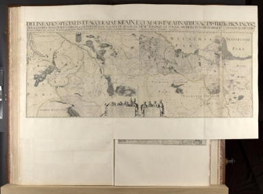


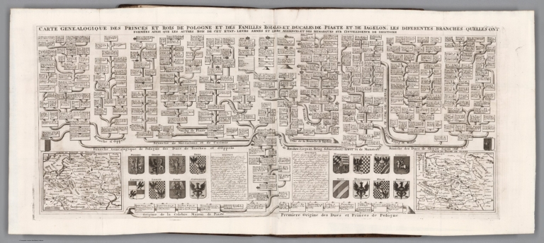
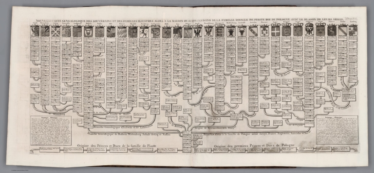


![Karta, predstavliaiushchaia Pol’shu i Moldaviiu s okolo lezhashchimi zemliami, sochinennaia pri Imper.[atorskoi] Akademii Nauk po noveishim izvestiiam Tituliarnym sovetnikom i Ad’iutantom Ivanom Truskotom [i.e. Map Displaying Poland and Moldavia with Surrounding Lands, Compiled Basing on the Latest Data by Titular Councilor, Adjunct Professor Ivan Truskot in the Imperial Academy of Sciences]](https://www.davidrumsey.com/rumsey/Size2/RUMSEY~8~1/205/15642000.jpg)