|
Author
[Ford Motor Company, Geological Survey (U.S.). Topographic Branch]
Full Title
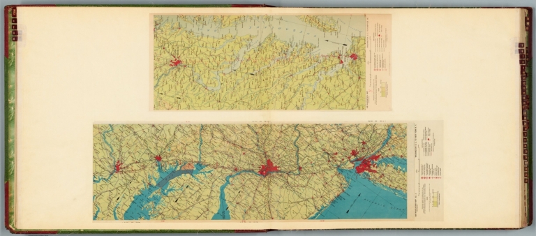
Air navigation map no. 3 (experimental) : Washington D.C. to New York, N.Y. Prepared under the direction of the Airways Section Office of the Chief of Air Service by the Topographic Branch, U.S. Geological Survey, 1923. Engineer Reproduction Plant, U.S. Army, Washington Barracks, D.C. 4915. 1923 - reprint 1926 - R-1927. -- Air navigation map [4] (experimental) : Washington D.C. to Hampton, Va. Prepared under the direction of the Airways Section, Office of the Chief of Air Corps by the Topographic Branch, U.S. Geological Survey, 1923. Engineer Reproduction Plant, U.S. Army, Washington Barracks, D.C. 6520. 1926.
List No
14501.004
Note
Two aeronautical charts representing the areas from Washington D.C., to New York, New York, and from Washington D.C. to Hampton, Virginia. Features military, municipal, commercial, emergency, and seaplane landing fields, as well as beacon lights. Also shows political boundaries, roads, railways, cities, towns, topography, bodies of water, and drainage. Relief shown with contour lines and color coding. Maps include latitudinal and longitudinal lines, legend, scale statements, and bar scales given in miles, as well as compass roses oriented toward top of sheet (with slight variation between the two maps). Color lithographs. Together, maps are 57 x 94 cm, on double sheet, 60 x 136 cm. Map number 4 provided with a handwritten annotation.
Author
[Ford Motor Company, United States. Hydrographic Office]
Full Title
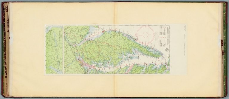
U.S. Navy aviation chart : Philadelphia - Norfolk. Washington, D.C. Published Feb. 1927, at the Hydrographic Office, under the authority of the Secretary of the Navy. 1st edition, Feb. 1927.
List No
14501.030
Note
Aeronautical chart representing the areas from Philadelphia, Pennsylvania, to Norfolk, Virginia. Features military, municipal, commercial, emergency, and seaplane landing fields, as well as racetracks, coast guard stations, lighthouses, and radio stations. Also shows roads, railways, cities, towns, bodies of water, drainage, and coastlines. Map includes latitudinal and longitudinal lines, a legend, scale statement, and bar scales given in nautical miles and statute miles, as well as a compass rose oriented toward top of sheet. Includes the seal of the Hydrographic Office, U.S. Navy. With one inset map: Chesapeake - Delaware Canal. Color lithograph. Map is 90 x 32 cm, on double sheet, 136 x 60 cm.
Author
[Tanner, Henry Schenck, 1786-1858, Melish, John]
Full Title
A Map of Philadelphia County Constructed by virtue of an Act of the Legislature of Pennsylvania
List No
15333.002
Note
The depiction of railroads around Philadelphia is very early and many lines are prospective.
Author
Trans World Airlines
Full Title
Map no. 1 : New York - Pittsburgh, Boston, Philadelphia, Washington, Baltimore. General Drafting Co. Inc., N.Y.
List No
14394.003
Note
Map of the air routes connecting New York, Pittsburgh, Boston, Philadelphia, Washington D.C. and Baltimore, as well as the greater vicinity. Also shows cities, airports, highways, railways, topography, bodies of water, coastlines, islands and time zones. Relief shown with shading and peak heights. Includes a legend and descriptive text, as well as notes throughout. With views featuring popular tourist sites, such as the Statue of Liberty of New York. Also with inset index map indicating the geographic location of the main map within the United States. Colored lithograph. Map is 26 x 42 cm, on double sheet 26 x 52 cm.
Author
Varle, Charles P.
Full Title
To The Citizens Of Philadelphia This New Plan Of The City And Its Environs Is respectfully dedicated By the Editor. 1802. P.C. Varle Geographer & Enginr. Del.
List No
5006.000
Note
A beautiful, early map of Philadelphia in full period color. The scale is given at 75 Perches to 1 inch. The city is shown from the Delaware River to the Schuylkil River with the environs on the north and south. 24 lettered references and 28 numbered references to important places and buildings are below the title and 24 wards are keyed in Roman numbers above the title. Many of the country houses and farms around the city are named, including Penn, Dr. Wistar, and other notable early residents. Three inset views show City Hall, the State House, Court House, Library, and Bank of the United States. The tile is surrounded by a decorative cartouche. The quality of the engraving is superb. Ristow mentions an undated edition that was possibly issued in the year Varle made the surveys, 1796, but more likely in 1802. Wheat and Brun list a c.1794 State I that has one less numbered building reference, no Roman numbered ward references, and "R. Scott Sculp. Philadelphia." This was Varle's first map published in the United States. Until 1807, Varle was known as Peter C. Varle; after 1807 he is known as Charles P. Varle.
Author
Appleton, D. & Co.
Full Title
Map of Philadelphia, Penn. Copyright 1891 by Matthews-Northrup Co. ... Buffalo, New York. (to accompany) The Library Atlas Of Modern Geography ... New York, D. Appleton And Company 1892. (on upper margin) Philadelphia 94.
List No
0026.241
Note
Color plan. Shows railways, street car lines, city blocks, parks, etc. Includes numerical references to depots, hotels, churches, major buildings, and points of interest.
Author
[Beers, F. W. (Frederick W.), F.W. Beers & Co.]
Full Title
Portable Steam engines ... John Ashcroft ... Andrews patent oscillating engines ... Wm. D. Andrews & Bro. ... Reed's patent consolidated engine and air pumps for oil wells, etc. John A. Reed ... McNab & Harlin ... manufacturers of brass goods ... pipe, and fittings ... (Entered ... 1865 ... Southern District of New York by F.W. Beers & Co. Ferd. Mayer & Co. Lithographers, 96 Fulton St., N.Y.)
List No
0062.048
Note
Twelve advertisements. Includes views of 3 engines. Other advertisers: Blakeslee & Co. -- P. Cassidy -- Seyfert, McManus & Co. -- Penn Boiler Works, D.F. Agnew & Co. -- Woodbury, Booth & Co. -- O'Hara Boiler Works, Morrow & Barnhill -- William Fisher, engine builder and machinist -- Reiseck & Bro., engine builders & machinists.
Author
[Beers, F. W. (Frederick W.), F.W. Beers & Co.]
Full Title
Petroleum Land Agency ... Geo. N. Townsend & Co. Thomas E. Bayley & Co. ... Titusville, Pa. Johnston & Bayley ... N.Y. mining agents. (Entered ... 1865 ... Southern District of New York by F.W. Beers & Co. Ferd. Mayer & Co. Lithographers, 96 Fulton St., N.Y.)
List No
0062.051
Note
Twenty-six advertisements. Includes view of G.N. Townsend & Co., Philadelphia. Other advertisers: H.H. Irvine -- Hamlen & Moore's Oil Exchange -- Hamlen, Moore & Co.'s Machine Shop -- J.C. Morris -- Meylert & Co. -- Drake Brothers -- C.W. Simmons -- E.H. Swain & Co. -- Petroleum Land Company -- Wagstaff & Goetchius -- Faucon & Beldin -- Lewis B. Page -- E.A. Marshall, Jr. -- McLaen, O'Neal & Co. -- Adams & Levis -- Banking House of Work, McCouch & Co. -- J.R. Fry -- Bowen & Fox -- Wm. O. Schock & Co. -- Hewes, Miller & Co. -- Davies Brothers -- Petroleum Stock Exchange, Geo. Henderson, Jr. -- Tack, Bro. & Co. -- P.F. Kelly & Co.
Author
[Beers, F. W. (Frederick W.), F.W. Beers & Co.]
Full Title
H.G. Leisenring's steam power Printing House ... Nos. 237 and 239 Dock Street, Philadelphia. (Entered ... 1865 ... Southern District of New York by F.W. Beers & Co. Ferd. Mayer & Co. Lithographers, 96 Fulton St., N.Y.)
List No
0062.054
Note
View surrounded by text.
Author
Bradford, Thomas G.
Full Title
Philadelphia. Entered ... 1838, by T.G. Bradford ... Massachusetts. Engraved by G.W. Boynton.
List No
0089.017
Note
In full color.
Author
Colton, G.W.
Full Title
Philadelphia. Published by J.H. Colton & Co. 172 William St. New York. Entered ... 1855 by J.H. Colton & Co. ... New York. No. 21.
List No
0149.027
Note
In full color by area. Regions of the city are numbered but map lacks legend for them.
Author
Colton, G.W.
Full Title
Philadelphia. Published By J. H. Colton. No. 172 William St. New York.
List No
0151.034
Author
Colton, G.W.
Full Title
Philadelphia. Published By G. W & C. B. Colton & Co. No. 172 William St. New York.
List No
0152.032
Author
[Lawrence, Martin, Washington, George]
Full Title
Newburgh and New Windsor, New York, (1:53,000), (upper right) Morristown, New Jersey, (scale 1:28,500), (upper left), Philadelphia (lower), showing localities associated with George Washington.
List No
0465.048
Note
Three uncolored maps on one plate. Includes a table showing locations in Philadelphia, Pa., associated with George Washington.
Author
Mitchell, Samuel Augustus
Full Title
Philadelphia.
List No
0537.015
Note
Full color by area with banks, churches, hotels and public buildings numbered.
Author
Mitchell, Samuel Augustus
Full Title
Philadelphia.
List No
0545.018
Note
Full color map. Includes index, and alphabetical reference to the wards.
Author
Mitchell, Samuel Augustus
Full Title
Plan Of Philadelphia. 21. Entered ... 1860, by S. Augustus Mitchell, Jr. ... Pennsylvania.
List No
0565.013
Note
City in full color by numbered area. Ferry routes shown across the Delaware River.
Author
Mitchell, Samuel Augustus Jr.
Full Title
Plan of Philadelphia. Entered ... 1865 by S. Augustus Mitchell, Jr. ... Pennsylvania.
List No
0572.020
Note
Full color map. Pages of 22-23 are omitted.
Author
Mitchell, Samuel Augustus Jr.
Full Title
Plan of Philadelphia. Entered ... 1867 by S. Augustus Mitchell, Jr. ... Pennsylvania.
List No
0579.020
Note
Color map. Showing roads, railroads, public buildings, etc.
Author
Mitchell, Samuel Augustus
Full Title
Plan of the city of Philadelphia and Camden. Drawn and engraved by W.H. Gamble, Philadelphia. Entered ... 1879 by S. Augustus Mitchell ... Washington. (1880)
List No
0586.018
Note
Hand colored. Shows wards, major buildings, railroads, ferries, etc.
Author
Mitchell, Samuel Augustus Jr.
Full Title
Plan of the city of Philadelphia and Camden. Drawn and engraved by W.H. Gamble. Copyright by S. Augustus Mitchell 1884.
List No
0592.021
Note
Hand colored. Relief shown by hachures. Shows wards, major buildings, railroads, ferries, etc.
Full Title
Plan of the city of Philadelphia and Camden. Drawn and engraved by W.H. Gamble. Copyright 1887 by Wm. M. Bradley & Bro. (1890)
List No
0594.020
Note
Hand colored. Relief shown by hachures. Shows wards, major buildings, railroads, ferries, etc.
Author
Polish Army Topography Service
Full Title
United States of America - (Chicago, Detroit, and Philadelphia). Pergamon World Atlas. Pergamon Press, Ltd. & P.W.N. Poland 1967. Sluzba Topograficzna W.P.
List No
0737.204
Note
Three maps: Chicago, Detroit, and Philadelphia.
Author
Society for the Diffusion of Useful Knowledge (Great Britain)
Full Title
Philadelphia. Published by the Society for the Diffusion of Useful Knowledge, 59 Lincolns Inn Fields, September, 1840. (London: Chapman & Hall, 1844)
List No
0890.199
Note
Engraved map. Hand col. Inset views: The United States Bank -- The Exchange. David Rumsey Collection copy has penciled note.
Author
Tanner, Henry S.
Full Title
Philadelphia. Published by H.S. Tanner, Philadelphia. Entered ... 1836, by Henry S. Tanner ... Pennsylvania. (above neat line) Tanner's Universal Atlas.
List No
0977.066
Note
In full color by area. Index to numbers and letters included.
Author
Tanner, Henry S.
Full Title
Philadelphia and Environs. (to accompany) The American Traveller; Or Guide Through the United States. Containing Brief Notices of the Several States, Cities, Principal Towns ... Third Edition. By H.S. Tanner. Philadelphia: Published by the Author, No. 51 South Third Street. 1837. (on verso) Entered ... 1836, by H.S. Tanner ... Pennsylvania.
List No
0978.004
Note
Uncolored map. With references to places and explanation of the Wards. 3rd edition; 1st was 1834; map unchanged. Catalog of Tanner's works at end of book. 144 page Guide Book with four maps of city plans. Fifth map is a large colored map entitled, "The Traveller's Guide or Map of the Roads, Canals & Rail Roads of the United States, With the distances from place to place by H.S. Tanner." At bottom of map, "Entered ... 1834, by H.S. Tanner ... Pennsylvania." Bound with linen embossed with a rose pattern. Label on cover states, "Tanner's American Traveller, or Guide through the United States."
Author
Tanner, Henry S.
Full Title
Philadelphia (to accompany) The American Traveller, or Tourists' and Emigrants' Guide Through the United States. Containing Brief Notices of the Several States, Cities, Principal Towns ... Ninth Edition, with several additional routes, and A New Map ... By H.S. Tanner. New York: Published by T.R. Tanner, 153 Broadway. 1844. (on verso) Entered ... 1844, by H.S. Tanner ... New York.
List No
0983.004
Note
Uncolored map. With references to places. Bookplate of Tanner's Map Store, N.Y. 144 page Guide Book. Includes maps and reference guides. New copyright notice of 1844 indicating that this is a very late edition; the map is changed from the earlier editions but is still copyright 1834, as in the earlier editions. Full color map entitled, "The Travellers Guide or Map of The Roads, Canals & Rail Roads of the United States, With the distances from place to place by H.S. Tanner 1844." at bottom, "Entered ... 1834, by H.S. Tanner ... Pennsylvania." Bound in linen with gild title, "Tanner's American Traveller or Guide through the United States with Maps, Plans &c."
Full Title
Outline map of the county and city of Philadelphia and vicinity. (Published by Stedman, Brown & Lyon, Philadelphia), 1872.
List No
1155.025
Note
Hand col. lithographed map. Shows wards, streets and roads, railroads, etc.
Full Title
Map of the compact portions of Philadelphia and Camden. (Published by Stedman, Brown & Lyon, Philadelphia), 1872.
List No
1155.026
Note
Hand col. lithographed map. Shows wards, major buildings, railroads, ferry routes, parks, cemeteries, etc.
Author
Luffman, John, 1756-1846
Full Title
Philadelphia. Engraved for Luffman's Select plans. Engrav'd & Publish'd March 1.1802, by J. Luffman. London.
List No
13189.154
Note
Hand colored city plan. Shows river, channel and fortress. Prime meridian is London. Includes historical text at the foot of map.
Author
[Gorshkov, Sergei Georgievich, Soviet Union. Voenno-Morskoĭ Flot]
Full Title
Porty Chesapikskogo Zaliva. Porty Filadel'fiya i Gamil'ton. (to accompany) Atlas okeanov : Atlanticheskiy i Indiyskiy Okeany 1977.
List No
13623.221
Note
5 maps on 1 sheet. Showing ports of the Chesapeake Bay. ports of Philadelphia and Hamilton. Relief shown by gradient tints and spot heights. Depth shown by bathymetric tints, isolines and soundings. Include elevation bar.
Author
Rand McNalley & Company
Full Title
Minneapolis, St. Paul, Minn., and vicinity -- Montreal, Que. -- New Orleans, La. -- Philadelphia, Pa., and vicinity.
List No
14003.059
Note
4 road maps of cities. Maps include compass roses and legends. Copyright by Rand McNally & Company, Chicago, Ill. Lithographed in the U.S.A.
Author
[France. Ministère des travaux publics. Administration des routes, France. Direction des cartes, plans et archives et de la statistique graphique, École nationale des ponts et chaussées (France)]
Full Title
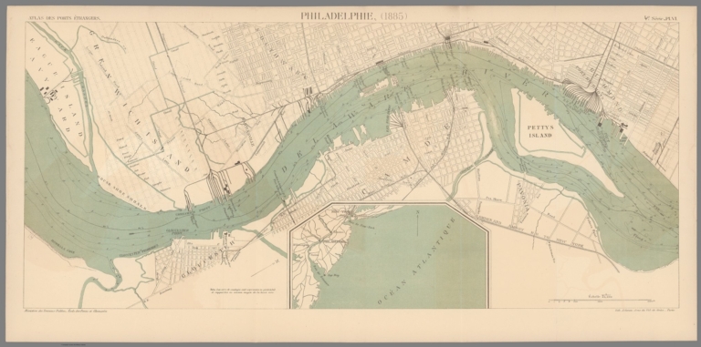
Philadelphie. (1885). 4e Série. Pl. VI. Ministère des Travaux Publics. Ecole des Ponts et Chaussées. Lith. A. Simon, 13, R. du Val-de-Grâce. Paris.
List No
14306.096
Note
Map showing the port of Philadelphia, Pennsylvania, in 1885. Features railways, streets, bridges, drainage, islands, docks, tides and soundings, with depths given in meters. Includes a bar scale and compass rose, with north oriented toward top-right of sheet. Descriptive text throughout. Lithograph in black, white and blue. With inset map: [Coast of Middle Atlantic States]. Together, maps are 28 x 65 cm, on fold-out sheet 33 x 68 cm. Bookplate title pasted to verso: Pl. VI. Philadelphie. Appears in Quatrième livraison.
Author
Cram, George Franklin, 1841-1928
Full Title
Map of Philadelphia.
List No
14372.282
Note
Map of Philadelphia, Pennsylvania. Shows political boundaries, cities, railroads, streets, bridges, parks, bodies of water, drainage, shorelines and islands. Colored lithograph. Map is 38 x 55 cm, on double sheet 45 x 67 cm.
Author
Colton, G.W.
Full Title
Philadelphia. Published By G. W & C. B. Colton & Co., No. 182 William St. New York.
List No
1550.031
Author
Beers, F. W. (Frederick W.)
Full Title
Map of Philadelphia. (1872)
List No
1573.044
Note
Hand col. lithographed map. Shows wards, streets, major buildings, parks, cemeteries, railroads, ferries, etc.
Author
[Colton, G.W., Fisher, Richard Swainson]
Full Title
New York, New Jersey, Pennsylvania, and Delaware. (inset) Vicinity of Philadelphia. (inset) Vicinity of New York.
List No
1690.064
Note
Relief shown by hachures.
Author
[Cram, George, Wood Brothers]
Full Title
New driving map of Philadelphia. (to accompany) The Columbian World's Fair atlas ... Published for: Wood Brothers Cash Store ... Unadilla, New York.
List No
1773.094
Note
Detailed color map on 2 pages. Shows roads, railroads, major buildings, etc.
Author
[Cram, George Franklin, Murray-Aaron, Eugene, 1852-1941.]
Full Title
Philadelphia. Published by George F. Cram, Chicago, Ill. (to accompany) Cram's atlas of the world, ancient and modern : new census edition -- indexed.
List No
1910.084
Note
In full color on 2 pages. Shows city blocks, railroads, roads, river, public buildings, etc.
Author
Rand McNally and Company
Full Title
Rand, McNally & Co.'s Philadelphia and Chicago.
List No
2094.065
Note
Philadelphia map at 1:48,000. Counties outlined in color. Railroads highlighted. Relief shown by hachures.
Author
Smith, J.L.
Full Title
(Covers to) Driving Map of Philadelphia and Vicinity. Published by J.L. Smith, 27 South Sixth St. Phila., Pa. 1882. Entered ... 1882 by J.L. Smith ... Washington.
List No
2459.001
Note
J.L. Smith succeeded to R.L. Barnes' map business. J.L. Smith was a map publisher in Philadelphia in the 1870-1890 period. He is not listed in Ristow, other than as a publisher of Martinet's Maryland map in its later editions. Folded into brown cloth covers 15.5x10.5 with "Smith's Map of Philadelphia And Vicinity" stamped in gilt.
Author
Smith, J.L.
Full Title
Driving Map of Philadelphia and Vicinity. Published by J.L. Smith, 27 South Sixth St. Phila., Pa. 1882. Entered ... 1882 by J.L. Smith ... Washington.
List No
2459.002
Note
J.L. Smith succeeded to R.L. Barnes' map business. J.L. Smith was a map publisher in Philadelphia in the 1870-1890 period. He is not listed in Ristow, other than as a publisher of Martinet's Maryland map in its later editions. Folded into brown cloth covers 15.5x10.5 with "Smith's Map of Philadelphia And Vicinity" stamped in gilt.
Author
Smith, J.L.
Full Title
(Composite of) Driving Map of Philadelphia and Vicinity. Published by J.L. Smith, 27 South Sixth St. Phila., Pa. 1882. Entered ... 1882 by J.L. Smith ... Washington.
List No
2459.003
Note
Full color map. Folded into brown cloth covers 15.5x10.5 with "Smith's Map of Philadelphia And Vicinity" stamped in gilt.
Author
Colles, Christopher
Full Title
From New York to Philadelphia. (47)
List No
2467.043
Note
Without color.
Author
Colles, Christopher
Full Title
From New York to Philadelphia. (50)
List No
2467.047
Note
Without color.
Author
Colles, Christopher
Full Title
From Philadelphia to Annapolis Maryland. (51)
List No
2467.048
Note
Without color.
Author
Mitchell, Samuel Augustus
Full Title
Plan of Philadelphia. Entered ... 1870 by S. Augustus Mitchell, Jr. ... Pennsylvania.
List No
2483.016
Note
Hand colored. Shows wards, major buildings, railroads, etc.
Author
Tanner, Henry S.
Full Title
Philadelphia and Environs
List No
2528.007
Note
8th edition, published by H. Tanner Jr. in Philadelphia and T.R. Tanner in New York, both presumably H. Tanner senior's sons. The large map appears unchanged from the 1840 edition. Large outline color map bound in back entitled, "The Travellers Guide or Map of the Roads, Canals & Rail Roads of the United States, With the distances from place to place by H.S. Tanner." At bottom of map, "Entered ... 1834, by H.S. Tanner ... Pennsylvania." Book bound with linen and with title embossed on cover, "Tanner's American Traveller or Guide through the United States with Maps, Plans &c. 1842."
Author
Tanner, Henry S.
Full Title
Manuscript Drawing
List No
2528.008
Note
8th edition, published by H. Tanner Jr. in Philadelphia and T.R. Tanner in New York, both presumably H. Tanner senior's sons. The large map appears unchanged from the 1840 edition. Large outline color map bound in back entitled, "The Travellers Guide or Map of the Roads, Canals & Rail Roads of the United States, With the distances from place to place by H.S. Tanner." At bottom of map, "Entered ... 1834, by H.S. Tanner ... Pennsylvania." Book bound with linen and with title embossed on cover, "Tanner's American Traveller or Guide through the United States with Maps, Plans &c. 1842."
Author
[Jones, T.W., Moore, S.S.]
Full Title
Philadelphia and the commencement of the road to New York. 1. Shallus fc.
List No
2646.001
Note
Map without color.
|