|
REFINE
Browse All : Images of Petersburg (Va.)
1-7 of 7
Author
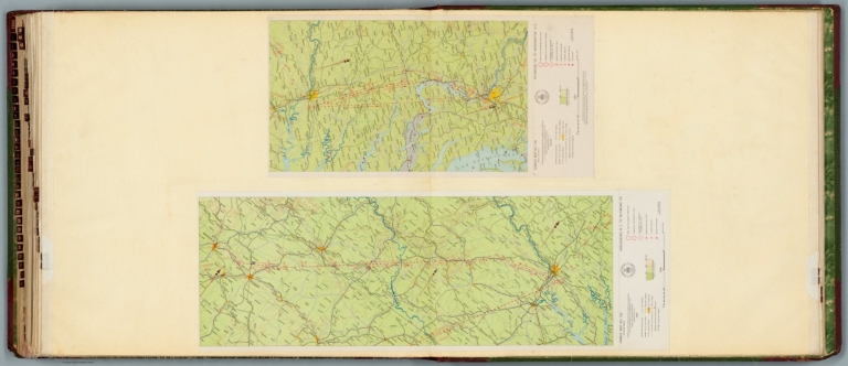
[Ford Motor Company, U.S. Coast and Geodetic Survey]
Full Title
Airway map no. 129 : Greensboro N.C. to Richmond Va. Compiled and printed for the Aeronautics Branch of the Department of Commerce by the Coast and Geodetic Survey, Washington, D.C. 1929. -- Airway map no. 130 : Richmond Va. to Washington D.C. Compiled and printed for the Aeronautics Branch of the Department of Commerce by the Coast and Geodetic Survey, Washington, D.C. Jan. 1930.
List No
14501.039
Note
Two aeronautical charts representing the areas from Greensboro, North Carolina, to Richmond, Virginia, and from Richmond, Virginia, to Washington, D.C. Features military, municipal, and commercial landing fields, seaplane anchorage and beacons. Also shows political boundaries, roads, railways, cities, towns, topography, bodies of water, drainage, and shorelines. Relief shown with contour lines and color coding. Maps include latitudinal and longitudinal lines, legend, scale statements, and bar scales given in miles, as well as compass roses oriented toward top and right of sheet, respectively. With the seal of the Department of Commerce, United States of America. Color lithographs. Together, maps are 56 x 81 cm, on double sheet, 60 x 135 cm.
Author
[Michler, Nathaniel, United States. War Department, Weyss, John E.]
Full Title
Sketch of routes from Petersburg, Chester Station and Manchester to Amelia Court-House, Va. By order of Col. T.M.R. Talcott, Com'dg. Engr., Troops, A.N. Va. Appomattox Court-House, Va. From surveys under the direction of ... N. Michler ... by command of ... A.A. Humphreys ... 1867. Surveyed and drawn by Maj. J.E. Weyss, assisted by F. Theilkuhl, J. Strasser and G. Thompson. High Bridge and Farmville, Va. From surveys under the direction of ... N. Michler ... 1867. Surveyed and drawn by Maj. J.E. Weyss, assisted by F. Theilkuhl, J. Strasser and G. Thompson. (with) Sketch of roads to Corinth, Miss. (with) Petersburg mine explosion, June 30, 1864. (with) Pittsburg, Tenn., March 24, 1862. Julius Bien & Co., Lith., N.Y. (1891-1895)
List No
1780.078
Note
Three col. maps with 3 ancillary maps. Relief shown by hachures. Two of the ancillary maps accompany letter of U.S. Grant.
Author
[Michler, Nathaniel, United States. War Department]
Full Title
Plan and section of batteries (or battery) ... on the main line of enemy's works in front of Petersburg, Va. Official: N. Michler, Major of Engineers, U.S.A. Siege of Petersburg, Va. from July 9th to July 31st, 1864 ... Official: N. Michler. Julius Bien & Co., Lith., N.Y. (1891-1895)
List No
1780.104
Note
12 technical drawings, b&w. Nos. 1-7, 9-11 are numbered E. no. 2-E. no.10 and show batteries numbered 3-22 and A. No. 8 and 12 are numbered D no. 2 showing field batteries, and D no. 5 showing Fort Davis.
Author
United States. War Dept. Engineer Bureau
Full Title
Region embraced in the Operations of the Armies against Richmond and Petersburg. Engraved at the Engineer Bureau, War Dep. 1865. Authorities. North of James & Appomattox from Photograph Map Captured from the Enemy and Surveys of Maj. P.S. Michie Corps Of Engineers. South of Do. from Surveys of Col. N. Michler Corps Of Engineers.
List No
3875.000
Note
Detailed map of the area between Richmond and Petersburg, showing the street patterns of both cities. Differs from the Stephenson 644 in not having the 39th Cong. 1st Session printed on it. A very elegant map. Two sheets joined; map without color. Plate 100:2 in "Atlas to Accompany..."
Author
[U.S. War Department, Weyss, John E.]
Full Title
Bermuda Hundred. From Surveys under the direction of Bvt. Brig. Gen N. Michler, Maj. of Engineers and Bvt. Lieut. Col. P.S. Michie, Capt. of Engineers By Command of Bvt. Maj. Genl. A.A. Humphreys, Brig. Genl. & Chief of Engineers. 1867. Surveyed & drawn by Maj. J.E. Weyss, assisted by F. Theilkuhl, J. Strasser & G. Thompson. Photolith. by the N.Y. Lithographing, Engraving & Printing Co., Julius Bien, Supt.
List No
3881.010
Note
Full printed color.
Author
[U.S. War Department, Weyss, John E.]
Full Title
Petersburg And Five Forks. From Surveys under the direction of Bvt. Brig. Gen N. Michler, Maj. of Engineers By Command of Bvt. Maj. Genl. A.A. Humphreys, Brig. Genl. & Chief of Engineers. 1867. Surveyed & drawn by Maj: J.E. Weyss, assisted by F. Theilkuhl, J. Strasser & G. Thompson. Photolith. by the N.Y. Lithographing, Engraving & Printing Co., Julius Bien, Supt.
List No
3881.011
Note
Full printed color.
Author
Hughes, W.C. Major
Full Title
Hughes Military Map Of Richmond & Petersburgh, Va. Showing the Rebel Fortifications drawn on the ground for the War Department by Major W.C. Hughes of Michigan. Published by Philip & Solomons, Washn. D.C. Print by J.F. Gedney, Washn. Willenbucher, Lith. Respectfully dedicated to the Army of the Potomac.
List No
5443.000
Note
Two color map on linen with blue used for the rivers. Two inset views entitled "Libby Prison" and "Belle Isle." Date estimated.
1-7 of 7
|