|
Full Title
Karte der Sudpolarregion. Polynesische Inselgruppen: Viti-Fidschi, Inseln. Hawaii-Sandwich, Inseln. Samoa-Schiffer, Inseln. (with) Victoria-Land. (Richard Andree. Herausgegeben von der Geographischen Anstalt von Velhagen & Klasing in Leipzig. 1881)
List No
1494.009
Note
Four color maps with 2 insets. Relief shown by hachures and spot heights. "IX.1879."
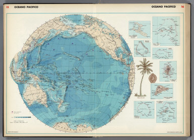
Full Title
Grosser Ocean, Meerestiefen und Telegraphenkabel. (with) Tahiti und Moorea. (with) Tonga, Freundschafts In. (with) Tongatabu. (with) Markesas Inseln. (with) Nukuhiva. (with) Hivaoa und Tahuata. (Richard Andree. Herausgegeben von der Geographischen Anstalt von Velhagen & Klasing in Leipzig. 1881)
List No
1494.013
Note
Colored map with 6 insets. Depths shown by soundings and color.
Author
[U.S. Coast and Geodetic Survey, U.S. Army Air Forces]
Full Title
Tuamotu Islands
List No
15328.023
Author
[U.S. Coast and Geodetic Survey, U.S. Army Air Forces]
Full Title
South Pacific
List No
15328.031
Author
Philip, George, 1870-1937.
Full Title
New Zealand. Part of Oceania
List No
15487.155
Author
Bartholomew, John
Full Title
The Orient. 1:55,000,000. Transverse Mercator Projection, Centered on Meridian. 135 (degree) E. Edited by John Bartholomew, M.C., LL.D. The Geographical Institute Edinburgh. Copyright, John Bartholomew & Son, LTD.
List No
1552.036
Note
Full color map. Note: Names underlined indicate larger scale inset map on plate 9. Island Ggroups East of the international Date Line are shown in volume V, plate 120. Insets: Marshall Islands, Gilbert and Ellice Islands, 1:10,000,000. New Hebrides and New Caledonia, 1:7,500,000. Fiji, 1:5,000,000. Vanua Levu, Vita Levu, Tonga, Kwajalein Atoll, 1:25000,000. Tongatapu Group, Vav'u Group, 1:1,000,000. Ocean Island, Wake Island Nauru, 1:250,000. Relief shown by gradient tints. Depth shown by soundings. No. 1591, and May 57, marked on the lower corners of plate. The Times Atlas on the upper left corner.
Author
Berghaus, Hermann
Full Title
Oceanien. (with) Victoria nach Brough Smyth. (with) Tasmanien nach R.M. Johnston und C.P. Sprent. (with) Landenge von Auckland n.v. Hochstetter. (with) Das Seenland (Neu-Seeland) nach d. 10. Juni 1886. (with) Hawaii-Vulkane veranderungen bis 1886. Entw. v. H. Berghaus 1886, Ausg. 1888. Gotha: Justus Perthes (1892)
List No
1578.014
Note
Lithographed geologic map, color, with 19 insets. Small inset maps not given in full title: Honolulu (Sandwich-Inseln) -- Makatea (Tuamotu-Gruppe) -- Bolabola (Gesellschafts-Inseln) -- Totoya (Viti-Inseln) -- Niuafu (Tonga-Inseln) -- Tova Riff (Viti In.) -- Vuata Vatua (Ono In.) -- Nukufetau (der Ellice Gruppe) -- Taiara (Tuamotu In.) -- Washington -- Jervis -- Enderbury (Phoenix In.) -- Roto-Mahana der warme See vor d. 10. Juni 1886 -- Maunga Rei.
Author
[Black, Adam, Black, Charles]
Full Title
Oceania and Pacific Ocean.
List No
1585.087
Author
Blackie, W.G.
Full Title
The Pacific Ocean.
List No
1589.087
Author
USSR (Union of Soviet Socialist Republics).
Full Title
(Map Title Page) 233-234. Australia and Oceania, Physical. 335. New Guinea and Solomon Islands.
List No
1603.244
Author
USSR (Union of Soviet Socialist Republics).
Full Title
(Map Title Page) 236-237. Australia, Oceania, Political. 238. New Zealand, New Caledonia, Fiji.
List No
1603.247
Author
USSR (Union of Soviet Socialist Republics).
Full Title
236-237. Australia, Oceania, Political. The World Atlas.
List No
1603.248
Author
USSR (Union of Soviet Socialist Republics).
Full Title
(Map Title Page) 242-243. Pacific and Indian Oceans. 244. Pacific and Indian Oceans Islands. Hawaiian Islands, Pearl Harbor - Honolulu, Tahiti I. and Moorea I., Samoa, Tutuila Island, Guam Islandm Comores Islands, Mascarene Islands.
List No
1603.253
Author
USSR (Union of Soviet Socialist Republics).
Full Title
242-243. Pacific and Indian Oceans. The World Atlas.
List No
1603.254
Author
USSR (Union of Soviet Socialist Republics).
Full Title
244. Pacific and Indian Oceans Islands. Hawaiian Islands, Pearl Harbor - Honolulu, Tahiti I. and Moorea I., Samoa, Tutuila Island, Guam Island Comores Islands, Mascarene Islands (Mauritius Island, Reunion Island). The World Atlas.
List No
1603.255
Note
Hawaiian Islands at a scale 1:2,500,000; Pearl Harbor - Honolulu (Hawaii) at a scale 1:250,000; Tahiti I. and Moorea I., and Tutuila Island, Guam Island at scale 1:1,000,000; Samoa, Comores Islands, Mascarene Islands (Mauritius Island, Reunion Island) all at 1:2,500,000.
Author
[Colton, G.W., Fisher, Richard Swainson]
Full Title
Oceanica. Australia, New Zealand. (inset) Sandwich Islands.
List No
1690.276
Note
Two maps on one sheet. Australia and New Zealand map at scale 29,213,000. Topographic profiles included.
Author
[Cram, George, Wood Brothers]
Full Title
Oceanica. (to accompany) The Columbian World's Fair atlas ... Published for: Wood Brothers Cash Store ... Unadilla, New York.
List No
1773.126
Note
Color map. Shows administrative divisions, cities and towns. Relief shown by hachures. Prime meridians are Greenwich and Washington. Includes population and area square miles.
Author
Debenham, Frank
Full Title
The Pacific. (Copyright) G.P. Ltd. (with inset map) Lonely Volcanic and coral islands rising as mountains from the depths of the vast Pacific Ocean.
List No
1794.043
Note
Color relief map with text, and colored view of Polynesian islanders. Relief shown by gradient tints. Depth shown by shaded relief.
Author
[Bory de Saint-Vincent, M. (Jean Baptiste GeneviFve Marcellin), 1778-1846, Desmarest, Nicolas, 1725-1815, Vincent]
Full Title
Theorie des vents (Ocean Pacifique). Grave par Berthe. (A Paris, Chez Mme. veuve Agasse, Imprimeur-Libraire, rue des Poitevins, no. 6. M.DCCCXXVII)
List No
1801.007
Note
Engraved map. Covers Australia, New Zealand and part of the Pacific. Prime meridians: Ferro and Paris.
Author
Huntington, Francis Junius, 1802-1878
Full Title
Pacific Ocean, its islands & coasts. Entered ... 12th day of August 1830 by F.J. Huntington ... Connecticut.
List No
1902.011
Note
Engraved map. Hand colored. Relief shown pictorially.
Author
[Cram, George Franklin, Murray-Aaron, Eugene, 1852-1941.]
Full Title
Map of the Pacific Ocean :Showing Distances between Principal Points, and the International date line. Published by Geo. F. Cram, Chicago, Ill. (to accompany) Cram's atlas of the world, ancient and modern : new census edition -- indexed.
List No
1910.173
Note
Detailed map of Oceana and the Pacific on 2 pages, extending from the West Coast of America to the East Coast of Asia.International date line and submarine cables shown in red lines.
Author
Hammond, C.S.
Full Title
Islands of the Pacific Ocean. Dominion of New Zealand. 2472. (insets of vicinities of) Auckland, Wellington, and Chatham Island.
List No
1954.036
Note
Pacific Ocean scales vary by island groups. New Zealand map scale at 1:6,897,000.
Author
Hammond, C.S.
Full Title
Asia. 7426.
List No
1954.037
Author
Hammond, C.S.
Full Title
High Spots of World War II in Asia & the Pacific. 3416. Strategic Islands and Areas of the Pacific War. 4465.
List No
1954.041
Note
Interesting short narrative on World War II. Islands and Areas map consists of 20 islands and island groups.
Author
Harrison, Richard Edes
Full Title
Pacific Arena. Orthographic Projection. (to accompany) Look At The World: The Fortune Atlas For world Strategy. By Richard Edes Harrison. Text by Editor of Fortune. New York: Alfred A. Knopf 1944. (on verso) Copyright 1944 by Time Incorporated.
List No
1970.027
Note
Full color map. Includes text, inset maps showing the other half and the world. Atlas contains 66, (2) page text, index, statistics, color, and black and white maps (some folded) and plans. Covers are teal blue with the title "Look at the world: the Fortune Atlas For world Strategy. By Richard Edes Harrison. Text by Editor of Fortune. New York: Alfred A. Knopf." in center.
Author
Houze, Antoine Philippe
Full Title
L'Oceanie en 1841. Dressee sous la direction de A. Houze. (In upper margin:) Atlas historique et geographique de l'Oceanie. (Paris, Chez P. Dumenil, editeur, rue des Beaux-Arts, 10. 1844)
List No
2010.101
Note
Hand colored map. Relief shown pictorially. Mercator? projection. Key in lower margin gives dates of European discoveries. Prime meridian: Paris.
Full Title
Oceanica and comparative N. America & Asia. Entered ... 1836, by Eleazer Huntington ... Connecticut.
List No
2022.016
Note
Engraved map. Hand colored. Relief shown by hachures.
Author
Institute of Social and Religious Research
Full Title
Plate 19. Oceania. (insets) New Hebrides. British New Guinea (Papua) and the Solomon Islands. Samoan Is.
List No
2030.052
Author
[Rees, Abraham, Tanner, Henry Schenck]
Full Title
Chart of the Pacific Ocean. H. S. Tanner. (to accompany) Atlas Modern. (The Cyclopedia; or, Universal Dictionary of Arts, Sciences, and Literature. 41 vol, 6 vol. of Plates, Ancient and modern atlas.)
List No
2076.033
Note
Engraved double page map. Showing Eastern Shores of Asia and the Western Coast of North America. Emphasizes coastal detail and major cities. Prime meridian is Greenwich.
Author
[Geographisches Institut (Weimar, Germany), Kiepert, Heinrich, 1818-1899]
Full Title
Australien. (with New South Wales). (with) Tasmania oder Van-Diemens Land. (with) Neu Seeland, New-Zealand. (with) Hawaii Archipelagus, Sandwich-Inseln. (with) Taheiti Archipelagus, Societats Inseln. Gezeichnet v. H. Kiepert. Gest. v. C. Kratz. Weimar, geographisches Institut, 1856.
List No
2077.066
Note
Engraved map. Outline hand col. Covers most of the Pacific Ocean. Scales of insets: New South Wales and Tasmania (ca. 1:5,100,000), New Zealand 1:10,000,000, Society Islands and Hawaii 1:5,000,000. Prime meridian: Ferro.
Author
[Bartholomew, J. G. (John George), 1860-1920, John Bartholomew and Son]
Full Title
South Pacific Ocean on Mercators projection. The Edinburgh Geographical Institute, John Bartholomew & Son, Ltd. "The Times" atlas. (London: The Times, 1922)
List No
2113.119
Note
Col. map. Relief shown by spot heights; depths by bathymetric tints and soundings. Shows ocean steamer routes with distances, submarine cables, railways, etc.
Author
[Bartholomew, J. G. (John George), 1860-1920, John Bartholomew & Co.]
Full Title
North Pacific Ocean on Mercators projection. The Edinburgh Geographical Institute, John Bartholomew & Co. "The Times" atlas. (London: The Times, 1922)
List No
2113.120
Note
Col. map. Relief shown by spot heights; depths by bathymetric tints and soundings. Shows ocean steamer routes with distances, submarine cables, railways, etc.
Author
[Bartholomew, J. G. (John George), 1860-1920, John Bartholomew and Son]
Full Title
(Composite of) South, North Pacific Ocean on Mercators projection. The Edinburgh Geographical Institute, John Bartholomew & Son, Ltd. "The Times" atlas. (London: The Times, 1922)
List No
2113.121
Note
Composite of 2 col. maps. Relief shown by spot heights; depths by bathymetric tints and soundings. Shows ocean steamer routes with distances, submarine cables, railways, etc. Contents: Pl. 102. South Pacific Ocean -- Pl. 103. North Pacific Ocean. Pl. 103 by John Bartholomew & Co.
Author
[Bartholomew, J. G. (John George), 1860-1920, John Bartholomew & Co.]
Full Title
Islands of Oceania on uniform scale. The Edinburgh Geographical Institute, John Bartholomew & Co. "The Times" atlas. (London: The Times, 1922)
List No
2113.132
Note
Nine col. maps. Relief shown by hypsometric tints and spot heights; depths by bathymetric tints. Contents: New Hebrides -- Hawaiian Islands -- Cook Islands -- Samoan Is. -- Society Is. -- Marquesas Is. -- New Caledonia and Loyalty Islands -- Fiji Islands -- Tonga Group.
Author
Bradford, Thomas G.
Full Title
Oceanica or Oceania. (to accompany) A Comprehensive Atlas, Geographical, Historical & Commercial. By T.G. Bradford. Boston: American Stationers' Company. Entered ... 1835, by Thos. G. Bradford ... Massachusetts.
List No
2120.145
Note
Color map. Shows countries, regions, cities and towns, rivers, etc. Relief shown pictorially. Prime meridians are Washington and Greenwich.
Author
[Instituto Geographico di Agostini, Bayer, Herbert]
Full Title
Oceano Pacifico. (insets) Isola Christmas (del Natale), Manihiki, Isole Truk, Bikini, Is. Wallis, Isola della Pasqua, Eniwetok, and Is. Gambier.
List No
2170.009
Note
Bathymetry tinted.
Author
[Instituto Geographico di Agostini, Bayer, Herbert]
Full Title
Australia, Oceania. (insets) Nuova Caledonia; Ie. Salomone; Ie. Figi; Ie. Tahiti; Ie. Samoa; Jaluit; Yap; Guam; Ie. Palau; Ie. Hawaii; Wake; Midway.
List No
2170.115
Note
Relief shown as combined hachures, shaded relief, and hypsometric tints; bathymetry also tinted.
Author
[Lapie, Alexandre Emile, Lapie, M. (Pierre), 1779-1850]
Full Title
Carte de l'Oceanie contenant l'Australie, la Polynesie et les iles asiatiques. Dressee par M. Lapie, 1er. Geographe du Roi et M. Lapie Fils, Geogphe. de S.A.R.M. le Dauphin. Paris, 1829. Chez Eymery Fruger et Cie., Rue Mazarine No. 30. La gravure dirigee et executee par Lallemand.
List No
2174.038
Note
Engraved map. Outline hand color. Relief shown by hachures. Prime meridian: Paris.
Author
[Stieler, Adolf, Lueddecke, R., Petermann]
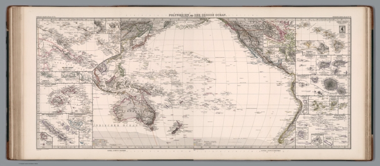
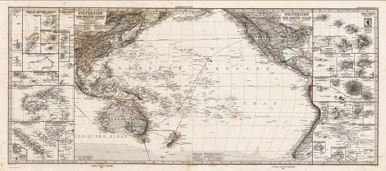
Full Title
Polynesien und (der Grosse Ocean) (Westliches Blatt) .
List No
2207.042
Author
[Stieler, Adolf, Lueddecke, R., Petermann]
Full Title
(Polynesien und) der Grosse Ocean (Oestliches Blatt). (insets) (Polynesian Islands).
List No
2207.043
Author
Stieler, Adolf
Full Title
(Composite Map) Polynesien und der Grosse Ocean.
List No
2207.044
Author
Vandermaelen, Philippe, 1795-1869
Full Title
(Covers to) Atlas universel de geographie physique, politique, statistique et mineralogique, sur l'echelle de 1/1641836 ou d'une ligne par 1900 toises, dresse par Ph. Vandermaelen, Membre de la Societe de Geographie de Paris, d'apres les meilleures cartes, observations astronomiques et voyages dans les divers Pays de la Terre; Lithographie par H. Ode, Membre de la Societe de Geographie de Paris. Sixieme partie. - Oceanique. Bruxelles. 1827.
List No
2212Q
Note
A complete set of the six volume Atlas Universel in original bindings of half red leather teal cloth covered boards with title "Vandermaelen. Atlas Universel..." embossed in gold on the spine. This monumental work was the first atlas of the world with all maps on the same scale (and a large scale at that - about one inch to 26 miles) and the first lithographed world atlas. If all the maps were joined together they would form a globe of 7.75 meters in diameter (such a globe was made in Brussels). The maps were published originally in parts of ten maps each, beginning in 1825 and ending in 1827. Vandermaelen's maps are frequently misunderstood because each map is usually best comprehended in the context of its neighboring maps - the maps do not function well on their own, since they were all meant to be joined. Koeman states that "His atlases, although unique in concept and size did not possess that fine touch of cartographic style which make them attractive for a collector..." We strongly disagree - the graphic art of the maps must be appreciated in the context of lithography, a developing art at the time; as lithographs, they are very well done. For many of the areas depicted, these maps are the largest scale maps made at the time, and the most detailed (particularly in the American West). Maps are hand painted in outline color.
Author
Vandermaelen, Philippe, 1795-1869
Full Title
Carte d'assemblage de l'Oceanique. (Dresse par Ph. Vandermaelen, lithographie par H. Ode. Sixieme partie. - Oceanique. Bruxelles. 1827)
List No
2212.328
Note
Hand col. lithographed index map. Relief shown by pictorially. Includes inset for Pierre and Alexandre islands. Prime meridian: Paris.
Author
Ziegler, J. M.
Full Title
Oceanien. Zum Atlas von J.M. Ziegler. Verlag der topogr. Anstalt v. Joh. Wurster u. Comp. in Winterthur. (1864)
List No
2227.008
Note
Colored map. Relief shown by hachures and spot heights. Shows whaling grounds, monsoons, ocean currents, colonies, shipping lanes, etc. Prime meridian: Ferro.
Author
[Fremin, A.R., Monin, C.V., Montemont, A.]
Full Title
Oceanie. Dressee par C.V. Monin. Paris. Grave sur Acier par Ales, Rue des Mathurins, , St. Jacques, No. 1. Imprime par Mangeon. Jules Berthelemier, Scrip. (1837)
List No
2359.024
Note
Uncolored engraved map. Relief shown by hachures. Rivers shown. Insets for southeastern Australia at 1:8,000,000 and southwestern Australia at 6,600,000. Inset table showing the nomenclature for the principal islands in the South Pacific.
Full Title
Pacific Ocean. T.K. Marshall sculp. (Published by John Conrad & Co., Philadelphia. 1804)
List No
2436.033
Note
Engraved map, uncolored. Shows coastal features, etc.
Author
[Stieler, Adolf, Petermann, A.]
Full Title
Polynesien Und Der Grosse Ocean Im Maassstabe von 1:40.000.000. (Westliches Blatt) Von A. Petermann. Gezeichnet v. E. Debes. Gest v. Stier & Jungmann. Gotha: Justus Perthes 1872.
List No
2449.082
Note
Map of Polynesia and the western Pacific Ocean including Australia and New Zealand. 18 inset maps detail the individual islands in the region.
Author
[Stieler, Adolf, Petermann, A.]
Full Title
Polynesien Und Der Grosse Ocean Im Maassstabe von 1:40.000.000. (Ostliches Blatt) Von A. Petermann. Gezeichnet v. E. Debes. Gest v. C. Stier. Gotha: Justus Perthes 1872.
List No
2449.083
Note
Map of islands in the eastern Pacific Ocean showing the United States and the coastline of South America. 17 inset maps detail the individual islands in the region.
Author
[Stieler, Adolf, Petermann, A.]
Full Title
(Composite of) Polynesien und der Grosse Ocean im Maassstabe von 1:40.000.000. Von A. Petermann. Gezeichnet v. E. Debes. Gest v. Stier & Jungmann. Gotha: Justus Perthes 1872.
List No
2449.084
Note
Map of the Pacific Ocean in outline color. Includes inset aps of individual islands.
Author
Goodrich, S.G.
Full Title
Maine. G. Boynton Sc. Entered ... by S.G. Goodrich of Massachusetts. (Costumes) Arabians, Negroes, Japanese, Otaheitans, Algerines, Malays. (Boston: Gray & Bowen ... 1831)
List No
2468.007
Note
Hand colored engraved map with 6 illustrations on facing page. Prime meridians: Washington, Greenwich.
Author
Goodrich, S.G.
Full Title
Pacific Ocean. British Islands. G. Boynton Sc. Entered ... by S.G. Goodrich of Massachusetts. (Boston: Gray & Bowen ... 1831)
List No
2468.016
Note
Two hand colored engraved maps on facing pages. Relief shown pictorially. Prime meridians: Washington and Greenwich.
Author
Mitchell, Samuel Augustus
Full Title
Map of Oceanica, exhibiting its various divisions, island groups &c. (with) Map of the Sandwich Islands. Entered ... 1867 by S. Augustus Mitchell, Jr. ... Pennsylvania. (1870)
List No
2483.057
Note
Hand colored map with inset. Relief shown by hachures. Shows settlements, rivers, etc. Prime meridians: Greenwich and Washington.
Author
Andriveau-Goujon, J.
Full Title
Carte de l'Oceanie d'apres les dernieres decouvertes. (with) Details des etablissemens anglais dans la Nouvelle Galles Meridionale. Publiee par J. Andriveau-Goujon, Rue du Bac, no. 21, Paris, 1850.
List No
2486.035
Note
Hand col. Relief shown by hachures. Prime meridian: Paris. "Atlas universel, no. 36."
Author
Stieler, Adolf
Full Title
No. LXII. Stieler's Hand-Atlas (No. 50). Australien nach Krusenstern u.A. in Mercators Projection.
List No
2506.031
Note
Revised from 1826 edition.
Author
[Stieler, Adolf, Stulpnagel, F.v.]
Full Title
No. LXII. Stieler's Hand-Atlas (No. 50a). Australien und Polynesien in Mercators Projection
List No
2507.118
Note
Revision of 1843 edition.
Author
[Stieler, Adolf, Berghaus, H.]
Full Title
Stieler's Hand-Atlas (No. 51). West-Polynesien.
List No
2507.121
Author
[Stieler, Adolf, Berghaus, H.]
Full Title
Stieler's Hand-Atlas (No. 52). Ost-Polynesien.
List No
2507.122
Note
Shows routes of exploration.
Author
Berghaus, Heinrich
Full Title
Karte vom Grossen Ocean, (Mare Pacifico); Zur Ubersicht der Stromungen, Temperatur und Handelsstrassen. Gegrundet auf die Beobachtungen, welche seit Magalhaens' Zeit bis auf die Preussischen Weltreisen gemacht sind. 2te Abtheilung: Hydrographie, No. 4. Gez. von I.C. Bar und dem Verfasser. gest. v. E.G. Edler. Gotha, Justus Perthes. 1837.
List No
2515.015
Note
The Pacific Ocean shown with currents, sea temperatures, and trade routes. Observations based up the voyages from Magellan to Preuss. In outline color.
Author
Berghaus, Heinrich
Full Title
Der Warme Meeresstrom Des Atlantischen und Der Kalte Strom Des Grossen Oceans in Parallele nach geographischer Lage und Ausdehnung Dargestellt. Edler sc. Gotha. 2te Abtheilung: Hydrographie, No. 6. Potsdam, gezeichnet in der geographischen Kunstschule. 1840. Westliche Lange von Paris. Gotha, bei J. Perthes. 1841.
List No
2515.017
Note
The map shows the warm Atlantic current and the cold Pacific currents, showing their geographical location and size. In outline color.
Author
Berghaus, Heinrich
Full Title
Karte von dem Vulkan Gurtel und dem Central Gruppen des Grossen Oceans; nach Leopold v. Buch; von Berghaus. Potsdam, 16 Juli 1838. 3te Abtheilung: Geologie, No. 9. Gezeichnet von F. Schelle. In Potsdam Gestochen von K. Kolbe. Gotha, J. Perthes, 1838.
List No
2515.036
Note
Map of the Pacific Ocean showing volcanic and earthquake activity. Circled regions of activity include the Philippines and Central America. In outline color.
Author
Berghaus, Heinrich
Full Title
Ethnographische Karte von Afrika von HBgs. Potsd. 5 Juni 1845. 8te Abtheilung: Ethnographie No 16. Gotha, bei J. Perthes. 1846.
List No
2515.079
Note
Full color map of Africa by ethnography. With an inset map of Australia, Polynesia, and the Pacific Islands.
Author
Mitchell, Samuel Augustus Jr., 1792-1868
Full Title
Oceanica including Malaysia, Australia and Polynesia. (to accompany) Mitchell's New Reference Atlas for the Use of Colleges, Libraries, Families and Counting Houses. Philadelphia: Published By E.H. Butler & Co. 1865. (inset) New Zealand.
List No
2516.036
Note
2 hand colored maps on 1 sheet. Relief shown by hachures. Showing political and administrative divisions, capitals, major cities, rivers and mountains. Prime meridians are Greenwich and Washington.
Author
Carey, Mathew
Full Title
A Map of the Discoveries made by Capts. Cook & Clerke in the Years 1778 & 1779 between the Eastern Coast of Asia and the Western Coast of North America, when they attempted to Navigate the North Sea. Also Mr. Hearn's discoveries to the North westward of Hudson's Bay, in 1772. J.T. Scott sculp. Engraved for Carey's American Edition of Guthrie's Geography improved.
List No
2542.020
Note
Uncolored.
Author
Woodbridge, William C.
Full Title
Pacific Ocean, with a view of Australia and Polynesia, and the Indian Archipelago. By W.C. Woodbridge ... Entered ... 1831, by William C. Woodbridge ... Connecticut. (1837?)
List No
2573.012
Note
Engraved map. Hand colored. Relief shown by hachures.
Author
[Geographisches Institut (Weimar, Germany), Graf, Carl]
Full Title
Australien. Neu bearbeitet v. C. Graf 1863. Gestochen v. W. Kratz I. u. C. Poppey jun. Weimar: Geographisches Institut. (insets) (Neu Sud Wales). (with) Tasmania oder Van-Diemens Land. (with) Neu Seeland, New-Zealand. (with) Hawaii Archipelagus, Sandwich-Inseln. (with) Taheiti Archipelagus, Societats Inseln. (to accompany) Hand - Atlas Der Erde Und Des Himmels.
List No
2595.070
Note
Outline hand color map by country and region. Color coded European possession. Shows provinces, cities, towns, roads, rivers, etc. Includes legend and explanation. Relief shown by hachures. Prime meridian is Ferro.
Full Title
Australien. (Efter Stielers Hand-Atlas. Stockholm, J.L. Brudin, 1852)
List No
2605.008
Note
Engraved map. Outline hand coloring. In German. Prime meridian: Ferro.
Author
Monin, C.V.
Full Title
Oceanie par C.V. Monin. (with) Colonie Anglaise de la Nouvelle Galles du Sud. Grave par Laguillermie, rue des Noyers, No. 56.
List No
2613.020
Note
Divisions outlined in color. Four scales. Prime meridian Paris. Relief shown with hachures.
Author
[Malte-Brun, Conrad, 1775-1826, Lapie, Pierre]
Full Title
Oceanique.
List No
2631.065
Note
Prime meridian is Paris.
Author
[Malte-Brun, Conrad, 1775-1826, Lapie, Pierre]
Full Title
Oceanique Orient.
List No
2631.068
Note
Prime meridian is Paris.
Author
Bradford, Thomas G.
Full Title
Oceanica or Oceania. (to accompany) A Comprehensive Atlas, Geographical, Historical & Commercial. By T.G. Bradford. William D. Ticknor, Boston. Wiley & Long, New-York. Entered ... 1835, by Thos. G. Bradford ... Massachusetts.
List No
2643.146
Note
Outline color map. Shows countries, regions, cities and towns, rivers, etc. Relief shown pictorially. Prime meridians are Washington and Greenwich.
Author
Carey, Mathew
Full Title
A Map of the Discoveries made by Capts. Cook & Clerke in the Years 1778 & 1779 between the Eastern Coast of Asia and the Western Coast of North America, when they attempted to Navigate the North Sea. Also Mr. Hearn's discoveries to the North westward of Hudson's Bay, in 1772.
List No
2721.063
Note
Outline color with dotted routes for the explorers. Prime meridians Greenwich and Philadelphia.
Author
[Brue, Adrien Hubert, 1786-1832, Picquet, C.]
Full Title
Carte generale de l'Oceanie ou cinquieme partie du Monde, par A. Brue, Geographe du Roi. Paris, 1827. Chez Chles. Picquet, Quai Conti No. 17, pres du Pont des Arts. Revue en 1834.
List No
2741.047
Note
Hand colored engraved map. Relief shown by hachures. Includes information from the Dumont d'Urville voyages published in 1833. Prime meridian: Paris. In embossed seal: Propriete acquise en 1835.
Author
[Brue, Adrien Hubert, 1786-1832, Picquet, C.]
Full Title
Carte particuliere de la Polynesie, (parties orientale et septentrionale de l'Oceanie). Redigee par A. Brue, Geographe du Roi ... Paris, 1826. Chez Chles. Picquet, Quai Conti No. 17, pres du Pont des Arts. Augmentee par l'auteur en 1827. Revue en 1834.
List No
2741.050
Note
Hand colored engraved map. Relief shown by hachures. Prime meridian: Paris. In embossed seal: Propriete acquise en 1835.
Author
[Dower, John Nicaragua, Teesdale, Henry]
Full Title
Chart of the Pacific Ocean. London: Published by Henry Teesdale & Co. Drawn & Engraved by J. Dower, Pentonville, London. (1844)
List No
2745.031
Note
Engraved, with colored margins of districts. Shows place names, roads, rivers, lakes, and islands. Relief shown with hachures. British possessions (Canada, Australia, New Zealand, New Caledonia, Hong Kong, Chusan, etc.) shown in red.
Author
[Stieler, Adolf, Petermann, A.]
Full Title
Stieler's Hand-Atlas No. 76. Polynesien und Der Grosse Ocean (Westliches Blatt). (insets) Various Pacific Islands.
List No
2761.084
Note
1879 revision.
Author
[Stieler, Adolf, Petermann, A.]
Full Title
Stieler's Hand-Atlas No. 77. Polynesien und Der Grosse Ocean (Ostliches Blatt). (insets) Various Pacific Islands.
List No
2761.085
Author
Johnston, W. & A.K.
Full Title
Oceania. (with) Western Australia. (with) Tasmania. (with) Viti or Fiji Islands. (with) Eastern Extremity of New Guinea. Keith Johnston's General Atlas. March 1912. Engraved, Printed, and Published by W. & A.K. Johnston, Limited, Edinburgh & London.
List No
2763.044
Note
Countries and districts outlined in color. Four insets. Relief shown by hachures.
Author
Rand McNally and Company
Full Title
Oceania and Malaysia. (insets) New Caledonia and Loyalty Islands. Hawaii (Sandwich Islands).
List No
2790.355
Author
Rand McNally and Company
Full Title
(Small Maps of Various Locations in the Pacific). Sydney. Guam. Samoa. Aukland.
List No
2790.364
Author
Cram, George Franklin
Full Title
Islands in the Pacific Ocean.
List No
2809.130
Note
Relief shown by hachures. Nineteen island groups shown.
Author
Cram, George Franklin
Full Title
Map of the Pacific Ocean (Showing Distances between Principal Points).
List No
2809.135
Note
Prime meridians Washington D.C. and Greenwich.
Author
Rand McNally and Company
Full Title
(Text Page) Rand, McNally Co.'s Oceania.
List No
2844FD
Note
Tables of geographical features keyed to map.
Author
Rand McNally and Company
Full Title
Rand, McNally & Co.'s Oceania and Malaysia. (with) New Caledonia and Loyalty Islands. (with) Hawaii (Sandwich Islands). (with) Eastern Portion of Polynesia.
List No
2844.103
Note
Relief shown by hachures. Three insets.
Author
Carey, Mathew
Full Title
A Map of the Discoveries made by Capts. Cook & Clerke in the Years 1778 & 1779 between the Eastern Coast of Asia and the Western Coast of North America when they attempted to Navigate the North Sea. Also Mr. Hearn's discoveries to the North westward of Hudson's Bay, in 1772. J.T. Scott sculp. Engraved for Carey's American Edition of Guthrie's Geography improved.
List No
2862.045
Note
Uncolored.
Author
Johnson, A.J.
Full Title
Johnson's China East Indies Australia And Oceanica By Johnson & Browning. No. 78-79.
List No
2905.053
Note
In full color with two views, the city of Bangkok and the harbor of Hong Kong. Sea routes traced of explorers including Cook, Perouse, and Butler.
Author
Carey, Mathew
Full Title
A Map of the Discoveries made by Capts. Cook & Clerke in the Years 1778 & 1779 between the Eastern Coast of Asia and the Western Coast of North America when they attempted to Navigate the North Sea. Also Mr. Hearn's discoveries to the North westward of Hudson's Bay, in 1772. J.T. Scott sculp. Engraved for Carey's American Edition of Guthrie's Geography improved.
List No
2931.046
Note
Uncolored.
Author
Fullarton, A. & Co.
Full Title
Oceania, or Islands in the Pacific Ocean, on Mercators Projection, Comprising Polynesia, Malaysia and Australasia. Compiled from the British Admiralty Charts, the Surveys of the U. States Exploring Expedition and Lieut. Raper's Table of Maritime Positions. By J. Hugh Johnson, F.R.G.S. LXXI. Engraved by A. Fullarton & Co. A. Fullarton & Co. Edinburgh, London & Dublin.
List No
3007.073
Note
In outline color.
Author
Stein, Christ. Gottfr. Dan.
Full Title
Australien. Entworfen von J.M. Ziegler 1862. Revid. 1864. Gestochen von W. Bruckner. J.C. Hinrichs'sche Buchhandlung, Leipzig. (1865)
List No
3134.007
Note
Hand colored map. Relief shown by hachures. Prime meridian: Ferro. "Stein, Neuer Atlas der ganzen Erde."
Author
Cummins Map Co.
Full Title
Oceania.
List No
3273.102
Note
Date estimated.
Author
Johnston, Alexander Keith
Full Title
Oceania. (with) Western Australia. (with) Tasmania. (with) Viti or Fiji Islands. (with) Eastern Extremity of New Guinea. By Keith Johnston, F.R.S.E. Keith Johnston's General Atlas. Engraved, Printed, and Published by W. & A.K. Johnston, Edinburgh & London.
List No
3287.041
Note
Countries and districts outlined in color. Four insets. Relief shown by hachures. Four scales.
Author
[Dower, John, Teesdale, Henry]
Full Title
Chart of Pacific Ocean. Drawn & engraved by J. Dower. London, Published by Henry Teesdale & Co. (to accompany) A New General Atlas of the World, from Drawings made Expressly for this Work, By John Dower.
List No
3326.034
Note
Outline hand color map. Shows coastlines, islands and place names. Relief shown by hachures. Prime meridian is Greenwich.
Author
Vancouver, George, 1757-1798
Full Title
(Title Page to) A Voyage Of Discovery To The North Pacific Ocean And Round The World In Which The Coast of North-West America Has Been Carefully Examined And Accurately Surveyed. Undertaken by His Majesty's Command, Principally With A View To Ascertain The Existence Of Any Navigable Communication Between The North Pacific and North Atlantic Oceans; And Performed In The Years 1790, 1791, 1792, 1793, 1794, and 1795 In The Discovery Sloop Of War, And Armed Tender Chatham, Under The Command Of Captain George Vancouver. In Three Volumes. London: Printed For G.G. And J. Robinson, Paternoster-Row; And J. Edwards, Pall-Mall. 1798.
List No
3354B
Note
Title page from the first volume describing the voyages. Atlas volume was printed without its own title page.
Author
Vancouver, George, 1757-1798
Full Title
(Index to) A Voyage Of Discovery To The North Pacific Ocean And Round The World In Which The Coast of North-West America Has Been Carefully Examined And Accurately Surveyed. Undertaken by His Majesty's Command, Principally With A View To Ascertain The Existence Of Any Navigable Communication Between The North Pacific and North Atlantic Oceans; And Performed In The Years 1790, 1791, 1792, 1793, 1794, and 1795 In The Discovery Sloop Of War, And Armed Tender Chatham, Under The Command Of Captain George Vancouver. In Three Volumes. London: Printed For G.G. And J. Robinson, Paternoster-Row; And J. Edwards, Pall-Mall. 1798.
List No
3354C
Author
Vancouver, George, 1757-1798
Full Title
A Chart Shewing part of the S.W. Coast of New Holland With the Tracks of His Majesty's Sloop Discovery and Armed Tender Chatham Commanded by George Vancouver Esqr. in the Year 1791. Engraved by T. Foot. Weston Place, Battle Bridge. No. 1. (with) eight inset maps. London. Published May 1st 1798, by J. Edwards Pall Mall and G. Robinson Paternoster Row.
List No
3354.001
Note
All maps uncolored. Inset maps included are: 1. A Survey of King George IIId Sound on the S.W. Coast of New Holland. 2. Dusky Bay in New Zealand Copied from a sketch of Captain Cook's with such Additions and improvements as where made by the Discovery and Chatham, in the Year 1791. 3. Pickersgills Harbour. 4. Anchor Island Harbour. 5. Facile Harbour. 6. A Sketch of the Snares with the Track of the Chatham between them. 7. Chatham Island. 8. The Island of Oparo. Maps include soundings and the tracks of the ships around the islands.
Author
Vancouver, George, 1757-1798
Full Title
Views of Parts of the South West Coast of New Holland, with the Islands of Oparo and the Snares. W. Alexander delt. from Sketches made on the Spot by J. Sykes. London. Published May 1st 1798, by R. Edwards New Bond Street and J. Edwards Pall Mall and G. Robinson Paternoster Row. Engraved by B.T. Pouncy.
List No
3354.002
Note
Uncolored views include Cape Chatham, Cape Howe, King George IIId Sound, Point Hood, the Snares, and the Island of Oparo.
Author
La Perouse, Jean-Francois de Galaup, comte de, 1741-1788
Full Title
Carte du Grand Ocean ou Mer du Sud. Dressee pour la Relation du Voyage de Decouvertes faites par les Fregates Francaises la Boussole et l'Astrolabe dans les annees 1785, 86, 87, et 88. P.F. Tardieu sculp. Atlas du Voyage de la Perouse no. 3. (Paris: L'Imprimerie de la Republique, An V, 1797)
List No
3355.003
Note
Engraved map. Emphasizes coastal detail; shows route of La Perouse. Prime meridian: Paris.
Author
[La Perouse, Jean-Francois de Galaup, comte de, 1741-1788, Prevost, Guillaume]
Full Title
Poulettes. Corne d'Ammon de la Mer du Sud, entre les tropiques. Dessine par Prevost. Grave par Hulk. Atlas du Voyage de la Perouse, no. 63. (Paris: L'Imprimerie de la Republique, An V, 1797)
List No
3355.063
Note
Fifteen engraved drawings.
Author
La Perouse, Jean-Francois de Galaup, comte de, 1741-1788
Full Title
Partie de la Mer du Sud comprise entre les Philippines et la Californie d'apres de Carte Espagnole trouvee sur le Galion pris par l'Amiral Anson en 1743, qui represente l'etat des connaissances a cette epoque, et les routes que suivaient ordinairement les Galions dans leur traversee de Manille a Acapulco. Partie de la Mer du Sud comprise entre les Philippines et la California d'apres une autre Carte Espagnole communiquee a La Perouse dans sa relache a Monterey, sur laquelle il avait trace sa route ainsi que les Iles qu'il avait reconnues, avec des notes sur celles qu'il n'avait pas retrouvee. Atlas du Voyage de la Perouse no. 65. (Paris: L'Imprimerie de la Republique, An V, 1797)
List No
3355.067
Note
Two engraved maps. Relief shown by hachures. Prime meridian: Paris.
Author
[La Perouse, Jean-Francois de Galaup, comte de, 1741-1788, Mourelle de la Rua, Francisco Antonio, 1750-1820]
Full Title
Carte d'une partie du Grand Ocean a l'E. et SE. de la Nouvelle Guinee pour l'intelligence du voyage de la Fregate Espagnole la Princesa commandee par D. Franco. Antonio Maurelle en 1781. Atlas du Voyage de la Perouse no. 68. (Paris: L'Imprimerie de la Republique, An V, 1797)
List No
3355.068
Note
Engraved map. Includes notes on dates of discoveries, sources of names used, etc.
Author
Fenner, Rest.
Full Title
Polynesia. Fenner Sc., Paternoster Row. (London, Joseph Thomas, 1835)
List No
3362.055
Note
Engraved map. Outline hand coloring.
Author
Glassford, W.A.
Full Title
1. Mean monthly rainfall, January. Photo. Lith. by Hoen & Co. Baltimore, MD. (on lower margin) S Ex 91- 50... 1. (to accompany) Charts and Tables of Rain-Fall On The Pacific Slope, With A Discussion of The Causes of The Wet and Dry Seasons, The Abundance and Deficiency in Different Portions, The Summer Rainy Season in Arizona, Etc. By W.A.Glassford ... Washington: Government Printing Office. 1888.
List No
3478.004
Note
Color map. Rainfall shown by isohyets and gradient tints. Include Scale of shades.
Author
Glassford, W.A.
Full Title
2. Mean monthly rainfall, February. Photo. Lith. by Hoen & Co. Baltimore, MD. (on lower margin) S Ex 91- 50... 1. (to accompany) Charts and Tables of Rain-Fall On The Pacific Slope, With A Discussion of The Causes of The Wet and Dry Seasons, The Abundance and Deficiency in Different Portions, The Summer Rainy Season in Arizona, Etc. By W.A.Glassford ... Washington: Government Printing Office. 1888.
List No
3478.005
Note
Color map. Rainfall shown by isohyets and gradient tints. Include Scale of shades.
Author
Glassford, W.A.
Full Title
3. Mean monthly rainfall, March. Photo. Lith. by Hoen & Co. Baltimore, MD. (on lower margin) S Ex 91- 50... 1. (to accompany) Charts and Tables of Rain-Fall On The Pacific Slope, With A Discussion of The Causes of The Wet and Dry Seasons, The Abundance and Deficiency in Different Portions, The Summer Rainy Season in Arizona, Etc. By W.A.Glassford ... Washington: Government Printing Office. 1888.
List No
3478.006
Note
Color map. Rainfall shown by isohyets and gradient tints. Include Scale of shades.
Author
Glassford, W.A.
Full Title
4. Mean monthly rainfall, April. Photo. Lith. by Hoen & Co. Baltimore, MD. (on lower margin) S Ex 91- 50... 1. (to accompany) Charts and Tables of Rain-Fall On The Pacific Slope, With A Discussion of The Causes of The Wet and Dry Seasons, The Abundance and Deficiency in Different Portions, The Summer Rainy Season in Arizona, Etc. By W.A.Glassford ... Washington: Government Printing Office. 1888.
List No
3478.007
Note
Color map. Rainfall shown by isohyets and gradient tints. Include Scale of shades.
Author
Glassford, W.A.
Full Title
5. Mean monthly rainfall, May. Photo. Lith. by Hoen & Co. Baltimore, MD. (on lower margin) S Ex 91- 50... 1. (to accompany) Charts and Tables of Rain-Fall On The Pacific Slope, With A Discussion of The Causes of The Wet and Dry Seasons, The Abundance and Deficiency in Different Portions, The Summer Rainy Season in Arizona, Etc. By W.A.Glassford ... Washington: Government Printing Office. 1888.
List No
3478.008
Note
Color map. Rainfall shown by isohyets and gradient tints. Include Scale of shades.
Author
Glassford, W.A.
Full Title
6. Mean monthly rainfall, June. Photo. Lith. by Hoen & Co. Baltimore, MD. (on lower margin) S Ex 91- 50... 1. (to accompany) Charts and Tables of Rain-Fall On The Pacific Slope, With A Discussion of The Causes of The Wet and Dry Seasons, The Abundance and Deficiency in Different Portions, The Summer Rainy Season in Arizona, Etc. By W.A.Glassford ... Washington: Government Printing Office. 1888.
List No
3478.009
Note
Color map. Rainfall shown by isohyets and gradient tints. Include Scale of shades.
Author
Glassford, W.A.
Full Title
7. Mean monthly rainfall, July. Photo. Lith. by Hoen & Co. Baltimore, MD. (on lower margin) S Ex 91- 50... 1. (to accompany) Charts and Tables of Rain-Fall On The Pacific Slope, With A Discussion of The Causes of The Wet and Dry Seasons, The Abundance and Deficiency in Different Portions, The Summer Rainy Season in Arizona, Etc. By W.A.Glassford ... Washington: Government Printing Office. 1888.
List No
3478.010
Note
Color map. Rainfall shown by isohyets and gradient tints. Include Scale of shades.
Author
Glassford, W.A.
Full Title
8. Mean monthly rainfall, August. Photo. Lith. by Hoen & Co. Baltimore, MD. (on lower margin) S Ex 91- 50... 1. (to accompany) Charts and Tables of Rain-Fall On The Pacific Slope, With A Discussion of The Causes of The Wet and Dry Seasons, The Abundance and Deficiency in Different Portions, The Summer Rainy Season in Arizona, Etc. By W.A.Glassford ... Washington: Government Printing Office. 1888.
List No
3478.011
Note
Color map. Rainfall shown by isohyets and gradient tints. Include Scale of shades.
Author
Glassford, W.A.
Full Title
9. Mean monthly rainfall, Spetember. Photo. Lith. by Hoen & Co. Baltimore, MD. (on lower margin) S Ex 91- 50... 1. (to accompany) Charts and Tables of Rain-Fall On The Pacific Slope, With A Discussion of The Causes of The Wet and Dry Seasons, The Abundance and Deficiency in Different Portions, The Summer Rainy Season in Arizona, Etc. By W.A.Glassford ... Washington: Government Printing Office. 1888.
List No
3478.012
Note
Color map. Rainfall shown by isohyets and gradient tints. Include Scale of shades.
Author
Glassford, W.A.
Full Title
10. Mean monthly rainfall, October. Photo. Lith. by Hoen & Co. Baltimore, MD. (on lower margin) S Ex 91- 50... 1. (to accompany) Charts and Tables of Rain-Fall On The Pacific Slope, With A Discussion of The Causes of The Wet and Dry Seasons, The Abundance and Deficiency in Different Portions, The Summer Rainy Season in Arizona, Etc. By W.A.Glassford ... Washington: Government Printing Office. 1888.
List No
3478.013
Note
Color map. Rainfall shown by isohyets and gradient tints. Include Scale of shades.
Author
Glassford, W.A.
Full Title
11. Mean monthly rainfall, November. Photo. Lith. by Hoen & Co. Baltimore, MD. (on lower margin) S Ex 91- 50... 1. (to accompany) Charts and Tables of Rain-Fall On The Pacific Slope, With A Discussion of The Causes of The Wet and Dry Seasons, The Abundance and Deficiency in Different Portions, The Summer Rainy Season in Arizona, Etc. By W.A.Glassford ... Washington: Government Printing Office. 1888.
List No
3478.014
Note
Color map. Rainfall shown by isohyets and gradient tints. Include Scale of shades.
Author
Glassford, W.A.
Full Title
12. Mean monthly rainfall, December. Photo. Lith. by Hoen & Co. Baltimore, MD. (on lower margin) S Ex 91- 50... 1. (to accompany) Charts and Tables of Rain-Fall On The Pacific Slope, With A Discussion of The Causes of The Wet and Dry Seasons, The Abundance and Deficiency in Different Portions, The Summer Rainy Season in Arizona, Etc. By W.A.Glassford ... Washington: Government Printing Office. 1888.
List No
3478.015
Note
Color map. Rainfall shown by isohyets and gradient tints. Include Scale of shades.
Author
Glassford, W.A.
Full Title
13. Mean annual rainfall. Photo. Lith. by Hoen & Co. Baltimore, MD. (on lower margin) S Ex 91- 50... 1. (to accompany) Charts and Tables of Rain-Fall On The Pacific Slope, With A Discussion of The Causes of The Wet and Dry Seasons, The Abundance and Deficiency in Different Portions, The Summer Rainy Season in Arizona, Etc. By W.A.Glassford ... Washington: Government Printing Office. 1888.
List No
3478.016
Note
Color map. Rainfall shown by isohyets and gradient tints. Include Scale of shades.
Author
Glassford, W.A.
Full Title
14. Last yearly rainfall known. Photo. Lith. by Hoen & Co. Baltimore, MD. (on lower margin) S Ex 91- 50... 1. (to accompany) Charts and Tables of Rain-Fall On The Pacific Slope, With A Discussion of The Causes of The Wet and Dry Seasons, The Abundance and Deficiency in Different Portions, The Summer Rainy Season in Arizona, Etc. By W.A.Glassford ... Washington: Government Printing Office. 1888.
List No
3478.017
Note
Color map. Rainfall shown by isohyets and gradient tints. Include Scale of shades.
Author
Glassford, W.A.
Full Title
15. Greatest yearly rainfall known. Photo. Lith. by Hoen & Co. Baltimore, MD. (on lower margin) S Ex 91- 50... 1. (to accompany) Charts and Tables of Rain-Fall On The Pacific Slope, With A Discussion of The Causes of The Wet and Dry Seasons, The Abundance and Deficiency in Different Portions, The Summer Rainy Season in Arizona, Etc. By W.A.Glassford ... Washington: Government Printing Office. 1888.
List No
3478.018
Note
Color map. Rainfall shown by isohyets and gradient tints. Include Scale of shades.
Author
Mitchell, Samuel Augustus
Full Title
Map of Oceanica. Engraved to illustrate Mitchell's school and family geography. Engraved by J.H. Young. Entered ... 1839 by S. Augustus Mitchell ... Connecticut.
List No
3559.017
Note
Engraved map. Hand colored. Relief shown by hachures. Shows populations, etc. Prime meridians: Greenwich and Washington.
Author
Rand McNally and Company
Full Title
Rand, McNally & Company's indexed atlas of the world map of Oceania and Malaysia. (with) New Caledonia and Loyalty Islands. (with) Hawaiian or Sandwich Islands. Copyright 1892, by Rand, McNally & Co. ... Engravers, Chicago, (1897)
List No
3565.040
Note
Col. map. Relief shown by hachures and spot heights. Title in margin: Rand, McNally & Company's indexed atlas of the world." Includes 3 insets, New Caledonia and Hawaii at (ca. 1:5,000,000) scale, and "Eastern portion of Polynesia on same scale" (as main map)
Author
Rand McNally and Company
Full Title
Rand, McNally & Company's indexed atlas of the world map of Australia. (with) Map of Sydney and vicinity. (with) Map of Melbourne and Port Phillip. Copyright 1892, by Rand, McNally & Co. (Chicago, 1897)
List No
3565.041
Note
Col. map. Relief shown by hachures. Includes 4 insets. Covers eastern half of country excluding Tasmania, plus 1 inset entitled "S.W. corner of Western Australia on same scale." Title in margin: "Australasia, Rand, McNally & Company's indexed atlas of the world."
Author
Rand McNally and Company
Full Title
Rand, McNally & Co.'s indexed atlas of the world map of New Zealand, Tasmania, and the Fiji Islands. (with) Chatham Islands. (with) King Island. Copyright 1892, by Rand, McNally & Co. (Chicago, 1897)
List No
3565.042
Note
Col. map. Relief shown by hachures and spot heights. Includes 4 insets. Scale of Tasmania and King Island insets (ca. 1:3,300,000), Fiji (ca. 1:3,800,000), Chatham Islands (ca. 1:1,500,000). Title in margin: "Indexed atlas of the world, Australasia."
Author
Mitchell, Samuel Augustus.
Full Title
Oceana or Pacific Ocean. (to accompany) A New Universal Atlas Containing Maps of the various Empires, Kingdoms, States and Republics Of The World. (inset) Nubia.
List No
3697.075
Note
Color copper lithograph map by region. Shows capitals and important towns. Includes explanations and notes. Prime meridian is Greenwich.
Author
[Barbie du Bocage, J.G., Dufour, Auguste-Henri (1798-1865)]
Full Title
Carte de L'Oceanie.
List No
3771.028
Author
Mitchell, Samuel Augustus
Full Title
The Pacific Ocean Including Oceanica, with its Several Divisions, Islands, Groups &c.. Entered ... 1850, by Thomas, Cowperthwait & Co. ... Pennsylvania. (with two inset maps) Antarctic Continent, and The Sandwich or Hawaiian Islands.
List No
3803.077
Note
Full color map by territorial ownership. With notes on the region along the track of the U.S. Exploring Expedition 1840. Relief shown by hachures. Prime meridian is Greenwich.
Author
Mitchell, Samuel Augustus Jr.
Full Title
Map of Oceanica, exhibiting its various divisions, island groups &c. (with inset) Map of the Sandwich Islands. Entered ... 1874, by S. Augustus Mitchell ... Washington.
List No
3804.065
Note
Hand colored map by region. Shows settlements, rivers, etc. Relief shown by hachures. Prime meridians are Greenwich and Washington.
Author
Duflot de Mofras, Eugene
Full Title
Carte De L'Ocean Pacifique Au Nord De L'Equateur. No. 2. Publie Par Arthus Bertrand. Grave par S. Jacobs. Voyage de Mr. Duflot de Mofras.
List No
4119.002
Note
Map of the Pacific Ocean including all of the North American continent. The "Route des Russes" is shown following the Aleutian Islands.
Author
Hall, S. (Sidney)
Full Title
Pacific Ocean. By Sidney Hall. London, published by Longman, Rees, Orme, Brown & Green, Paternoster Row, June 1828.
List No
4224.035
Note
Engraved map. Boundaries hand col. "The figures annexed to the islands indicate the date of their discovery." Also numbered XXXIV.
Author
Mitchell, Samuel Augustus
Full Title
The Pacific Ocean Including Oceanica with its several Divisions, Islands, Groups &c. Entered ... 1850 by Thomas Cowperthwait & Co., ... Pennsylvania.
List No
4328.075
Note
Full color map by major divisions. With a notes on the region. With two insets showing edge of the Antarctic Continent along the track of the U.S. Exploring Expedition 1840, and The Sandwich or Hawaiian Islands. Shows capitals, towns, etc. Relief shown by hachures. Prime meridian is Greenwich.
Author
[Berghaus, Heinrich, Berghaus, Hermann, Luddecke, R., Geyer, F.]
Full Title
Oceanien. Entw. v. H. Berghaus 1886, Ausg. 1888. Gotha: Justus Perthes. (On upper margin) I. Abt. Geologie No. XV. Berghaus' physikal atlas No. 15. (to Accompany) Berghaus' Physikalischer Atlas. (Begrundet 1836 durch Heinrich Berghaus) ... Gotha: Justus Perthes. 1892. (19 insets).
List No
4391.025
Note
Color lithograph map. Insets: Victoria -- Tasmanien -- Landenge von Auckland -- Maunga Rei -- Das Seenland -- Hawaii-Vulkane -- Roto-Mahana -- Honolulu -- Makatea -- Bolabola -- Totoya -- Niuafu -- Tova Riff -- Vuata Vatua -- Nukufetau -- Taiara -- Washington -- Jervis -- Enderbury.Showing majorrivers and river basins. Principal geological features are shown by color or symbols. Relief shown by contours and spot heights. Depth shown by isolines and soundings. Includes table of geologic formations. Prime meridian is Greenwich.
Author
[United States Exploring Expedition (1838-1842), Wilkes, Charles, 1798-1877]
Full Title
Chart of the Viti Group or Feejee Islands by the U.S. Ex. Ex. Charles Wilkes Esq. Commander. 1840. Eng. by Sherman & Smith, N.Y.
List No
4442.003
Note
Map without color. Detailed chart with elevation shown by hachures.
Author
United States Exploring Expedition (1838-1842)
Full Title
Low Archipelago or Paumotu Group by the U.S. Ex. Ex. 1839. (Philadelphia: Lea & Blanchard. 1845)
List No
4442.014
Note
Uncolored engraved map. Relief shown by hachures. Shows ship tracks, extent of missionaries and cannibals, etc.
Author
United States Exploring Expedition (1838-1842)
Full Title
Groups in the western part of the Pacific Ocean examined and surveyed by the U.S. Ex. Ex. (Philadelphia: Lea & Blanchard. 1845)
List No
4442.060
Note
Uncolored engraved map. Relief shown by hachures. Shows track of ships.
Author
United States Exploring Expedition (1838-1842)
Full Title
Map of the Sooloo Sea and Archipelago by the U.S. Ex. Ex., 1842. Engraved by Edwd. Yeager, Philada. (Philadelphia: Lea & Blanchard. 1845)
List No
4442.074
Note
Uncolored engraved map. Relief shown by hachures. Shows tracks of ship Vincennes and tender Flying Fish. Oriented with north toward right.
Author
[Bradford, Thomas G., Goodrich, S.G.]
Full Title
Pacific Ocean. Engraved by Boynton. Entered ... 184 by S.G. Goodrich ... Massachusetts.
List No
4453.049
Note
Full color by land mass.
Author
Seaman, James V.
Full Title
A map of the discoveries made by Capts. Cook & Clerke in the years 1778 & 1779 between the eastern coast of Asia and the western coast of North America when they attempted to navigate the North Sea, also Mr. Hearn's discoveries to the north westward of Hudson's Bay. Published by J.V. Seaman, 296 Pearl St., N. York. (1821)
List No
4536.025
Note
Engraved map. Outline hand color.
Author
Mitchell, Samuel Augustus
Full Title
The Pacific Ocean including Oceania with its several Divisions, Islands, Groups, &c. 75. Entered according to Act of Congress in the year 1856 by Charles Desilver in the Clerk's office if the District Court of the Eastern District of Pennsylvania.
List No
4557.076
Note
Major divisions shown in tinted color. Meridian Greenwich. Notes on the region. Inset showing edge of the Antarctic Continent along the track of the U.S. Exploring Expedition 1840.
Author
Cram, George Franklin
Full Title
Oceanica.
List No
4558.082
Author
Carey, Mathew
Full Title
A Map of the Discoveries made by Captn. Cook & Clerke in the Years 1778 & 1779 between the Eastern Coast of Asia and the Western Coast of North America, when they attempted to Navigate the North Sea. Also Mr. Hearn's discoveries to the North westward of Hudson's Bay, in 1772.
List No
4577.058
Note
Outline color with dotted routes for the explorers.
Author
[Bourquin, Frederick, Mitchell, Samuel Augustus, Tanner, Henry S.]
Full Title
Oceana or Pacific Ocean. 70. (1848)
List No
4578.072
Note
Lithographed. Relief shown with hachures. Inset shows Wilkes' discoveries along the coast of Antarctica.
Author
[Brue, Adrien Hubert, 1786-1832, Levasseur, E.]
Full Title
Carte Generale de l'Oceanie, cinquieme partie du monde. Dresse par A. Brue, Geographe. Reoue par E. Levasseur, Membre de l'Institut, Institut Geographique de Paris. Ch. Delagrave & Cie. Editeurs de la Societe de Geographie. 58 Rue des Ecoles. Atlas Universel en 67 feuilles No. 48.
List No
4607.047
Note
Relief shown by hachures. Prime meridian Paris. Electric telegraph shown. Possessions shown for England, France, Spain, Holland, Portugal, and the United States.
Author
[Brue, Adrien Hubert, 1786-1832, Levasseur, E.]
Full Title
Carte Particuliere de La Polynesie (parties orientale dt septentrionale et l'Oceanie). Dresse par A. Brue, Geographe. Reoue par E. Levasseur, Membre de l'Institut, Institut Geographique de Paris. Ch. Delagrave & Cie. Editeurs de la Societe de Geographie. 58 Rue des Ecoles. Atlas Universel en 67 feuilles No. 51.
List No
4607.050
Note
Relief shown by hachures. Prime meridian Paris.
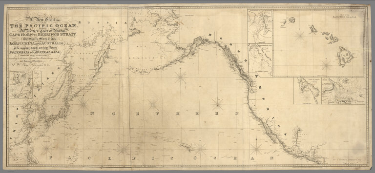
Author
Norie, J.W.
Full Title
A New Chart of The Pacific Ocean, Exhibiting The Western Coast of America, From Cape Horn To Beerings Strait, The Eastern Shores of Asia Including Japan, China and Australia, and all the numerous Islands and known Dangers Situated in Polynesia and Australasia, Correctly Drawn And Regulated according to the most Approved and Modern Surveys and Astronomical Observations By J.W. Norie, Hydrographer, &c.&c. Additions 1836. Stephenson, Engraver. London. Published ... October 1st 1825, by J.W. Norie & Co. (with) seven inset maps listed in Notes. (Northern Sheet)
List No
4612.001
Note
See the South Atlantic chart by Blunt (#4610) for comments. Inset charts from left to right: 1. Port Lloyd, 2. Arzobispo or Bonin Isles, 3. Honoruru or Fair Haven, 4. Karakakooa Bay, 5. Chart of the Sandwich Islands, 6. Port Sn. Diego, 7. The Entrance Of San Francisco Harbour.
Author
Norie, J.W.
Full Title
A New Chart of The Pacific Ocean, Exhibiting The Western Coast of America, From Cape Horn To Beerings Strait, The Eastern Shores of Asia Including Japan, China and Australia, and all the numerous Islands and known Dangers Situated in Polynesia and Australasia, Correctly Drawn And Regulated according to the most Approved and Modern Surveys and Astronomical Observations By J.W. Norie, Hydrographer, &c.&c. Additions 1836. Stephenson, Engraver. London. Published ... October 1st 1825, by J.W. Norie & Co. (with) seven inset maps listed in Notes. (Southern Sheet)
List No
4612.002
Note
See the South Atlantic chart by Blunt (#4610) for comments. Inset charts from left to right: 1. Port Lloyd, 2. Arzobispo or Bonin Isles, 3. Honoruru or Fair Haven, 4. Karakakooa Bay, 5. Chart of the Sandwich Islands, 6. Port Sn. Diego, 7. The Entrance Of San Francisco Harbour.
Author
Arrowsmith, John
Full Title
Pacific Ocean, By J. Arrowsmith. (Map) 38. London, Pubd. 15 Feby. 1842, by J. Arrowsmith, 10 Soho Square.
List No
4613.038
Note
In outline color. Includes part of Asia, all of Australia, the west coast of South America, and an outline of the United States (and then Canada) stretching from Florida to Alaska.
Author
Brue, Adrien Hubert, 1786-1832
Full Title
Mappe-monde 4e feuille. H. Brue, dir. (Par H. Brue, Ingenieur-Geographe de S.A. Royale. A Paris, Chez Desray ... (et) Goujon ..., 1816)
List No
4614.006
Note
Engraved map in outline color. SW sheet of 4 sheet map. Relief shown by hachures. Prime meridian: Paris. "Atlas universel no. 5."
Author
Brue, Adrien Hubert, 1786-1832
Full Title
Oceanie ou cinquieme partie du Monde. Comprenant l'archipel d'Asie, l'Australasie, la Polynesie, &c. Par H. Brue. Carte encyprotype reduite de celle sur 4 feuilles du meme auteur. Dirigee par H. Brue. A Paris, Chez Desray ... (et) Goujon ..., 1814.
List No
4614.044
Note
Engraved map. Outline hand col. Prime meridian: Paris. "Dediee & presentee a Monsieur ... par H. Brue, Ingenieur-Geographe de S.A. Royale." "Atlas universel no. 36."
Author
Brue, Adrien Hubert, 1786-1832
Full Title
Oceanie ou cinquieme partie du Monde. Comprenant l'archipel d'Asie, l'Australasie, la Polynesie, ou le continent de la Nouvelle-Hollande et les iles du Grand Ocean., &c. Ou outre und grande partie de l'Amerique et des cotes de l'Asie. Carte encyprotype dressee par H. Brue, Ingenieur-Geographe. (H. Brue direx.) A Paris, Chez Desray ... (et) J. Goujon ..., 1814.
List No
4614.045
Note
Engraved map. Outline hand col. "Oceanie 1ere feuille" (NW sheet). Includes text. Prime meridian: Paris. "Atlas universel no. (37)."
Full Title
Oceanie 2e. feuille. (Carte encyprotype dressee par H. Brue, Ingenieur-Geographe. H. Brue direx. A Paris, Chez Desray ... (et) J. Goujon ..., 1814)
List No
4614.046
Note
Engraved map. Outline hand col. NE sheet covering North America, Hawaii and the eastern Pacific. Prime meridian: Paris. "Atlas universel no. (38)."
Full Title
Oceanie 3e. feuille. (Carte encyprotype dressee par H. Brue, Ingenieur-Geographe. H. Brue direx. A Paris, Chez Desray ... (et) J. Goujon ..., 1814)
List No
4614.047
Note
Engraved map. Outline hand col. SW sheet covering the East Indies, Australasia, and the southwestern Pacific. Includes inset map. "Dediee & presentee a S.A.R. Monsieur, Comte d'Artois par ... H. Brue." Prime meridian: Paris. "Atlas universel no. (39)."
Full Title
Oceanie 4e. feuille. (Carte encyprotype dressee par H. Brue, Ingenieur-Geographe. H. Brue direx. A Paris, Chez Desray ... (et) J. Goujon ..., 1814)
List No
4614.048
Note
Engraved map. Outline hand col. SE sheet. Prime meridian: Paris. "Atlas universel no. (40)."
Author
Brue, Adrien Hubert, 1786-1832
Full Title
(Composite of) Oceanie ou cinquieme partie du Monde. Comprenant l'archipel d'Asie, l'Australasie, la Polynesie, ou le continent de la Nouvelle-Hollande et les iles du Grand Ocean., &c. Ou outre und grande partie de l'Amerique et des cotes de l'Asie. Carte encyprotype dressee par H. Brue, Ingenieur-Geographe. H. Brue direx. A Paris, Chez Desray ... (et) J. Goujon ..., 1814.
List No
4614.049
Note
Engraved map on 4 sheets. Outline hand col. Includes text. Includes inset map. "Dediee & presentee a S.A.R. Monsieur, Comte d'Artois par ... H. Brue." Prime meridian: Paris. "Atlas universel no." 37-40.
Author
[Tardieu, Ambroise, Vuillemin, A., Duvotenay, Erhard, Testarode, E.]
Full Title
Oceanie.
List No
4697.031
Author
[Brue, Adrien Hubert, 1786-1832, Marzolla, Benedetto]
Full Title
Carta generale dell'Oceania. Questa carta e stata eseguita sull'originale di Brue, pubblicato nel 1827, e riveduto nel 1834 ... Napoli 1841. Compilata, ed eseguita su pietra da Benedetto Marzolla. Real Litografia Milit.
List No
4714.045
Note
Lithographed map. Hand col. Relief shown by hachures. Includes statistical tables and notes. Prime meridian: Paris.
Author
Cram, George Franklin
Full Title
Islands in the Pacific Ocean.
List No
4727.097
Note
Nineteen small maps of Pacific islands. Prime meridians Washington D.C. and Greenwich. Relief shown by hachures. With printed color.
Author
[Schrader, Vivien St Martin, L.]
Full Title
Planisphere. Feuille 1. Basin du Pacifique. Carte 2. Dresse et Desine par E. Giffault. Librarie Hachette. Imp. Dufrenoy 11-36. Grave par Delaune, la lettre par Er. et P. Dumas-Vorxet.
List No
4730.002
Note
Number and title also on outside front of sheet. Lithographed. Folded. Full color. Countries outline tinted. Legend to colonial ownership. Relief shown by shading and hachures. Meridian Paris.
Author
[Schrader, Vivien St Martin, L.]
Full Title
Principaux Archipels d'Oceanie. Carte 79. Dresse par Ch. Bonnesseur et D. Aitoff. 2-31. Imp. Dufrenoy, Paris. Librarie Hachette. Grave par R. Lobrot. La lettre par H. Delgoffe.
List No
4730.079
Note
Seven principal island groups in the South Pacific represented at various scales. Number and title also on outside front of sheet. Lithographed. Folded. Full color. Relief shown by shading and hachures. Meridian Paris.
Author
Gray, Ormando Willis
Full Title
Gray's Atlas Map of Oceanica, 1873.
List No
4740.014
Note
Shows explorers routes and dates. Covers Polynesia, Australasia, and Malaysia. Prime meridians Washington D.C. and Greenwich. Relief shown by hachures.
Author
Delamarche, Felix.
Full Title
Carte de L'Oceanie ... 1846.
List No
4758.041
Author
Dussieux, L.
Full Title
157. Carte Generale de l'Oceanie. (inset) Carte de la Colonie de la Nouvelle Galles.
List No
4759.143
Author
Flemming, Carl
Full Title
Australien. Druck und Verlag von C. Flemming in Glogau. (1855)
List No
4765.084
Note
Hand colored lithographed map. Relief shown by hachures. Prime meridians: Paris, Greenwich and Ferro. Mercator projection.
Author
Radefeld, Carl Christian Franz, 1788-1874
Full Title
Neueste Karte von Australien. Nach den bessten Quellen entworfen und gezeichnet vom Hauptm. Radefeld. 1846. (with) Van Diemens Land. (with) Sudwestspitze von Neu Holland mit der Colonie am Schwaan-Flusse. (with) Das Innere von Neu-Sud-Wales. Aus der Geographischen Graviranstalt des Bibliograph. Instituts zu Hildburghausen, Amsterdam, Paris u. Philadelphia, (1860)
List No
4807.124
Note
Engraved map. Boundaries hand col. Relief shown by hachures. Covers the Pacific Ocean. Scale of the 3 inset maps is (ca. 1:5,500,000). "Meyer's Handatlas No. 94." Prime meridians: Paris and Ferro.
Author
Mitchell, Samuel Augustus
Full Title
Oceana or Pacific Ocean.
List No
4835.087
Author
[Stieler, Adolf, Stulpnagel, F.v.]
Full Title
No. LXII. Stieler's Hand-Atlas (No. 50a). Australien und Polynesien in Mercators Projection.
List No
4973.117
Note
Revision of 1843 edition.
Author
[Stieler, Adolf, Berghaus, H.]
Full Title
Stieler's Hand-Atlas (No. 51). West-Polynesien.
List No
4973.120
Author
Stieler, Adolf
Full Title
Stieler's Hand-Atlas (No. 52). Ost-Polynesien.
List No
4973.121
Note
Shows routes of exploration. Revision of 1848 edition.
Author
Stieler, Adolf
Full Title
(Advertisement - back liner). Atlanten im Verlag von Justus Perthus in Gotha.
List No
4973.122
Author
Garnier, F. A., 1803-1863
Full Title
Oceanie spheroidale. Atlas spheroidal & universel de geographie dresse par F.A. Garnier, geographe. Vve. Jules Renouard, Editeur, R. de Tournon, no. 6, Paris. 1860. Imp. Sarazin, r. Git-le-Coeur, 8. Paris.
List No
5023.020
Note
Full col. Relief shown hachures. Prime meridian: Paris. On globe in cartouche: Sphericite de la terre.
Author
Garnier, F. A., 1803-1863
Full Title
Oceanie. Atlas spheroidal & universel de geographie dresse par F.A. Garnier, geographe. Vve. Jules Renouard, Editeur, Rue de Tournon, no. 6, Paris. 1860. Imp. de Sarazin, R. Git-le-Coeur, 8, Paris.
List No
5023.060
Note
Full col. Relief shown by hachures. Prime meridian: Paris. On globe in cartouche: Sphericite de la terre.
Author
Garnier, F. A., 1803-1863
Full Title
Les divers archipels de l'Oceanie. (with) Groupe de la Nouvle. Caledonie. (with) Archipel des Iles Sandwich. Atlas spheroidal & universel de geographie dresse par F.A. Garnier, geographe. Ve. Jules Renouard, Editeur, R. de Tournon, no. 6, Paris. 1860. Imp. Sarazin, r. Git-le-Coeur, 8, Paris.
List No
5023.063
Note
Full col. Relief shown by hachures. Scales of insets: New Caledonie (ca. 1:5,100,000), Hawaii (ca. 1:5,800,000). Prime meridian: Paris. On globe in cartouche: Sphericite de la terre.
Author
Rand McNally and Company
Full Title
(Text Page) Continent of Africa - Governments, Districts, Islands, Lakes, Mountains, Rivers, and Towns. Oceania - Islands, Lakes, Mountains, Rivers and Creeks, and Towns.
List No
5028FY
Note
Geographical features keyed to map; populations of towns.` Relief shown with hachures.
Author
Rand McNally and Company
Full Title
Commercial Atlas of America. Rand McNally Standard Map of Oceania and Malaysia. (with) Eastern Protion of French Polynesia. (with) Hawaiian Is. (with) New Caledonia and Loyalty Islands.
List No
5028.193
Note
Relief shown by hachures.
Author
Rand McNally and Company
Full Title
(Text Page) Philippine Islands. Provinces, Islands, Lakes, Mountains, Mountain Peaks and Volcanoes, Rivers, and Towns.
List No
5028FZ
Note
Geographical features keyed to map; populations of provinces and towns. Relief shown with hachures.
Author
Rand McNally and Company
Full Title
Commercial Atlas of America. Rand McNally Standard Map of Philippine Islands. (with) Philippine Islands and China Sea. (with) Manila and Vicinity. (with) Batan and Babuyan Is.
List No
5028.195
Note
Regional inset at scale 1:14,542,000. Manila inset at scale 1:423,000. Batan map is a continuation of main map.
Author
Rand McNally and Company
Full Title
(Text Page) Philippine Islands. Provinces, Islands, Lakes, Mountains, Mountain Peaks and Volcanoes, Rivers, and Towns.
List No
5028GA
Note
Geographical features keyed to map; populations of towns. Relief shown with hachures.
Author
Rand McNally and Company
Full Title
Commercial Atlas of America. Rand McNally Standard Map of The Pacific Ocean and Bordering Lands.
List No
5028.196
Note
Shows steamship routes, radio stations, submarine cables, and the International Date Line.
Author
[Sohr, Karl, Flemming, Carl]
Full Title
Australien.
List No
5200.074
Author
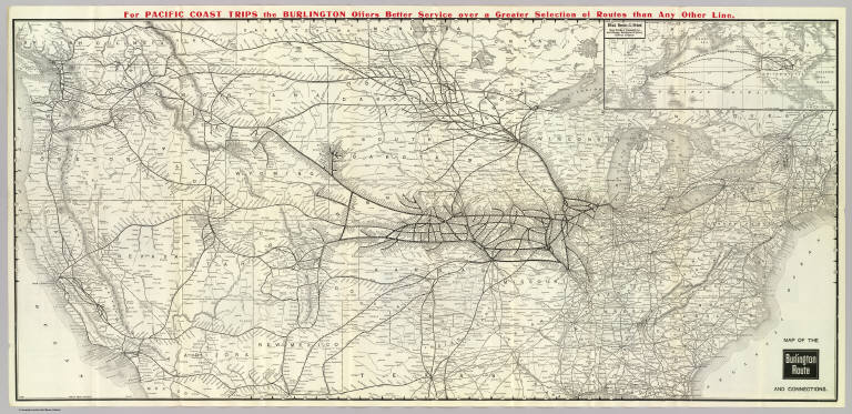
Chicago, Burlington & Quincy Railroad Company
Full Title
Map of the Burlington Route and connections. Poole Bros. Chicago. 5-20-'07 ... (inset map) Direct routes to the Orient. Great Northern Steamship Co. and Chicago, Burlington & Quincy Railway Company.
List No
5286.001
Note
Relief shown by hachures. Covers U.S. and southern Canada except for southern Texas, Louisiana and Florida, and northern Maine. Inset map: scale (ca. 1:100,000,000); "6-19-'05." Line of text in red in upper margin.
Author
Tanner, Henry S.
Full Title
Oceana Or Pacific Ocean. Published by Carey & Hart, Philadelphia. (above neat line) Tanner's Universal Atlas.
List No
5363.071
Note
In full color by county of possession. Engraved. Relief shown by hachures.
Author
Letts, Son & Co.
Full Title
The Pacific Ocean. Letts's popular atlas. Letts, Son & Co. Limited, London. (1883)
List No
5371.142
Note
Colored map. Depths shown by bathymetric tints. Shows currents, limit of drift ice, cities, coastlines, etc. Inset map: British Isles on same scale.
Author
Letts, Son & Co.
Full Title
Polynesia, or Islands of the Pacific Ocean. Letts's popular atlas. Letts, Son & Co. Limited, London. (1883)
List No
5371.143
Note
Colored map. Relief shown by hachures and spot heights. Shows cities, British consulates, vice-consulates and consular agents, etc. Contents: Mariana Is. or Ladrones -- Pelew Is. or Palaos -- Gilbert Ids., Kingsmill or Scarborough Range -- Marshall Ids. -- Otdia or Romanzoff Group -- Galapagos -- Marquesas Is. or Mendana Arch(ipelag)o -- Hawaii Archipelago or Sandwich Ids. -- Samoa or Navigator Ids. -- Admiralty Isles, New Ireland or Tombara, New Britain or Birara, Salomon (sic) Islands -- Santa Cruz Is. -- Vanikoro Id. -- Fiji Islands, Tonga or Friendly Is. -- Tonga-Tabou -- Norfolk Id -- The Low Archipelago -- Otaheite or Tahiti -- Cooks or Hervey Isles -- Pitcairn Island -- Juan Fernandez.
Author
[Aaron, Eugene Murray, Cram, George Franklin]
Full Title
(Covers to) Alaska. Published by Geo. F. Cram, Chicago, Ill. (on verso) Map of the territory of Hawaii. Published by Geo. F. Cram. (with) Minor U.S. possessions in the Pacific Ocean. Compiled from the latest surveys by Eugene Murray Aaron. (1901?)
List No
5409A
Note
Enclosed in a paper covers 17x11 and bound with indexes of Alaska, the Yukon District, Canada and the Hawaiian Islands. Cover title "Cram's Standard Map and Shippers' Guide of Alaska with District of Yukon, Canada; and Hawaiian Islands Accompanied by Complete Indexes, Locating Districts, Cities, Towns, Villages, Post Offices, Railroad Stations, Express Offices, etc. George F. Cram, 55 to 61 Market Street, Chicago. 130 Fulton Street, New York."
Author
[Aaron, Eugene Murray, Cram, George Franklin]
Full Title
Map of territory of Hawaii. Published by Geo. F. Cram, Chicago, Ill. (with) Honolulu. (with) Midway Islands (Western Hawaiian Chain). (with) Minor U.S. possessions in the Pacific Ocean. Compiled from the latest surveys by Eugene Murray Aaron. George F. Cram, engraver & publisher, Chicago, Ill. (1901?)
List No
5409.002
Note
Full color map with 2 insets and 6 ancillary maps. Contents of "Minor U.S. Possessions in the Pacific Ocean": The island of Guam (Guajan or Guahan), southernmost of the Ladrone or Mariana Islands -- Baker Island (New Nantucket Isl) -- Wake Island -- Midway Islands (Western Hawaiian Chain) -- Hawaiian Group and the Westward Islands in the Pacific Ocean -- Howland Island. Relief shown by hachures and spot heights. Shows settlements, railroads, submarine cable, etc. "U-O-V-V."
Author
Buache, Philippe, 1700-1773
Full Title
Carte physique de la Grande Mer ci-devant nommee Mer du Sud ou Pacifique; ou se voient les grandes chaines de montagnes qui traversent les parties les plus orientales de l'Asie et les occidles. de l'Amerique; et leurs continuations dans le fond de la Mer, indiquees par les isles, bancs &c. Avec la representation de ce que l'on conjecture sur la Mer Glaciale Antarctique. Dressee et presentee a l'Acad. des Sc. le 5. Septbre 1744. Par Philippe Buache. Publiee sous le privilege de l'Academie du 4. Septbre. 1754. Grave par Desbruslins, Pere, 1757.
List No
5698.007
Note
Engraved hand col. map. Relief shown by hachures. Inset: Carte de la Mer Glaciale Antarctique. "45."
Full Title
The Pacific Ocean. George Philip & Son, Ltd. The London Geographical Institute. (1922)
List No
5746.020
Note
Color lithographed map. Depths shown by layer tints. Shows mail routes and duration, steamship routes, distances, navigable waters for large steamers, canals, principal railways, cables, lighthouses, lightships, docks, coaling stations, British and American consular offices, naval stations, dockyards, etc.
Full Title
Australasian and Polynesian ports. George Philip & Son, Ltd. The London Geographical Institute. (1922)
List No
5746.021
Note
Color lithographed map. Depths shown by layer tints. Shows mail routes and duration, steamship routes, distances, navigable waters for large steamers, canals, principal railways, cables, lighthouses, lightships, docks, coaling stations, British and American consular offices, naval stations, dockyards, etc. Inset maps: Perth & Fremantle. Scale 1:200,000 -- Wellington. Scale 1:200,000 -- Samoa Islands. Scale 1:2,500,000.
Full Title
The Pacific Ocean--cables and wireless stations. George Philip & Son, Ltd. The London Geographical Institute. (1922)
List No
5746.033
Note
Color lithographed map. Relief shown by altitude tints and spot heights; depths shown by layer tints. Shows also currents and oiling stations. Includes inset map of Tonga and Fiji and 3 sections.
Author
Ruhle von Lilienstern, August
Full Title
Hemisphaere des Stillen Oceans. Berlin 1824 von R.v.L.
List No
5759.004
Note
Shows land masses outlined in color and basic hydrography.
Author
Reichard, C. G.
Full Title
Atlas des ganzen Erdkreises in der Central-Projection entworfen von C.G. Reichard. Zweyte Tafel. 1803.
List No
5762.002
Note
Engraved hand colored map. Relief shown by hachures. Shows settlements, rivers, Asia in full color, Australia in outline color, etc. Prime meridian: Ferro.
Author
Reichard, C. G.
Full Title
Atlas des ganzen Erdkreises in der Central-Projection entworfen von C.G. Reichard. Dritte Tafel. 1803.
List No
5762.003
Note
Engraved hand colored map. Relief shown by hachures. Shows settlements, rivers, continents in outline color, etc. Prime meridian: Ferro.
Full Title
Map of Oceanica, exhibiting its various divisions, island groups &c. (with) Map of the Sandwich Islands. Copyright 1886 by Wm. M. Bradley & Bro.
List No
5784.067
Note
Hand colored map with inset. Relief shown by hachures. Shows settlements, rivers, etc. Prime meridians: Greenwich and Washington.
Author
Jouvet et Cie.
Full Title
Oceanie. Atlas St. Cyr. G. Hue. Furne, Jouvet et Cie. Editeurs. Imp. Lemercier et Cie. Paris. Grave par J. Geisendorfer, 12 r. de l'Abbaye, Paris. (1882)
List No
5785.039
Note
Relief shown by stippling. Shows colonies in lists.
Author
[Bayer, Herbert, Container Corporation of America]
Full Title
Pacific Islands and Australia. (insets) (New Caledonia, Hawaiian Islands, Solomon Islands, Fiji, Tahiti, Samoa, Jaluit, Yap, Palau, Midway, Wake, Pearl Harbor, and Oahu).
List No
5842.140
Note
Relief depicted by hachures and hypsometric tints.
Author
[Bayer, Herbert, Container Corporation of America]
Full Title
Pacific Ocean.
List No
5842.141
Note
Hemispherical map of Pacific Ocean. Small map showing Micronesia, Melanesia, and Polynesia. Waves and atolls explained in diagrams and text. Bathymetry depicted by hypsometric tints.
Author
[Gross, Alexander, Geographia Map Company]
Full Title
Pacific Ocean. Copyright "Geographia" Map Co. (Produced by) Alexander Gross, F.R.G.S. (to accompany) "Geographia", Atlas of the World : Comprising 33 pages of colored maps, 10 pages of black and white maps, and 8 pages of useful information. Produced under the direction of Alexander Gross. F.R.G.S. Fellow of the Royal Geographical, Royal Economical, Royal Statistical, royal Meteorological and royal Aeronautical Societies. Copyright 1935 by "Geographia" Map Co., 11 John St., New York.
List No
5966.027
Note
Uncolored map. Shows railways, canals, steamer routes, and distances in nautical miles. Relief shown by spot heights. Prime meridian is Greenwich.
Author
McGraw-Hill Book Company
Full Title
Indian and Pacific Oceans Physical.
List No
6350.037
Note
Shaded relief of ocean bathymetry.
Author
[U.S. Geological Survey, Alpha, Tau Rho]
Full Title
Eastern Murray Fracture Zone and Transverse Ranges.
List No
6353.082
Author
[U.S. Geological Survey, Alpha, Tau Rho, Gerin, Marybeth]
Full Title
Oblique Map of the Northern California Continental Margin.
List No
6353.083
Author
[U.S. Geological Survey, Alpha, Tau Rho]
Full Title
Oblique Map of Southern California, Santa Barbara to San Deigo.
List No
6353.088
Author
[U.S. Geological Survey, Alpha, Tau Rho]
Full Title
Southern California Borderland Oblique Map of the Northwestern Part.
List No
6353.089
Author
[U.S. Geological Survey, Alpha, Tau Rho, Normark, William R., Hess, Gordon R.]
Full Title
Suprafan, Part of the Navy Submarine Fan, California Continental Borderland.
List No
6353.090
Author
[U.S. Geological Survey, Alpha, Tau Rho]
Full Title
Ventura-Oxnard Offshore.
List No
6353.091
Author
[U.S. Geological Survey, Alpha, Tau Rho, Morley, James M.]
Full Title
Oblique Map of Southwest Pacific.
List No
6353.100
Author
[U.S. Geological Survey, Alpha, Tau Rho]
Full Title
Oblique Map of the Crest of the East Pacific Rise near the Mouth of the Gulf of California.
List No
6353.117
Author
Mitchell, Samuel Augustus
Full Title
The Pacific Ocean including Oceania with its several Divisions, Islands, Groups, &c. 75. Entered according to Act of Congress in the year 1859 by Charles Desilver in the Clerk's office if the District Court of the Eastern District of Pennsylvania.
List No
6727.080
Note
Major divisions shown in tinted color. Meridian Greenwich. Notes on the region. Inset showing edge of the Antarctic Continent along the track of the U.S. Exploring Expedition 1840.
Author
[Eliot, George Fielding, Thompson, Kenneth, W.]
Full Title
[World War II battlefronts]. Map VI. The Southwest Pacific. Copyright, 1944, by Remington Rand, Inc. Printed in U.S.A. (Map signed by) Kenneth W. Thompson. (text signed by) George Fielding Eliot. (on lower margin) X600LB.
List No
6758.006
Note
Color map. ncludes text titled "Island-hopping towards Japan in short and long hops." Shows boundaries, railroads and major cities. Relief shown by landform drawing.
Author
[Eliot, George Fielding, Thompson, Kenneth, W.]
Full Title
[World War II battlefronts]. Map VII. The North Pacific. Copyright, 1944, by Remington Rand, Inc. Printed in U.S.A. (Map signed by) Kenneth W. Thompson. (text signed by) George Fielding Eliot. (on lower margin) X600LB.
List No
6758.007
Note
Color map. Includes text titled "Here the enemy trusts in the protection of vast ocean distances." Shows boundaries, railroads and major cities. Relief shown by landform drawing.
Author
[Manning, F.E., Army Orientation Course, Special Service Division Army Service Forces]
Full Title
Target Tokyo. Newsmap. Monday, October 18, 1943. ... Vol. II No. 26. Prepared and Distributed by the Army Orientation Course. Special Service Division Army Service Forces, War Dept.,2E581 Pentagon Bldg., Washington D.C. U.S. Government Printing Office: 1943 - 538110.
List No
6769.001
Note
Shaded relief map centered on Tokyo, Japan. Has a cut-away scale for measuring distances from Tokyo or, alternatively one can use the concentric rings. Some flight routes and mileages shown. Hemispherical view.
Author
[Harrison, Richard Edes, Army Orientation Course, Special Service Division Army Service Forces]
Full Title
Newsmap. Monday, May 7, 1945. ... Vol. IV No. 3F. (Central Europe). (Eastern Pacific).
List No
6771.002
Note
Includes one photograph.
Author
Stieler, Adolf
Full Title
Australien: Nach Mercators Projection, entw. u. gez.v. C.G. Reichard. 1816. Gest. v. L. Hess.(on upper right margin) Hand-Atlas No. 50. (to accompany) Hand-Atlas uber alle Theile der Erde, nach dem neuesten Zustande und uber das Weltgebaude.
List No
6830.090
Note
Engraved hand colored outline map. Mercators Projection. Relief shown by hachures. Includes text.
Author
Bellin, Jacques Nicolas, 1703-1772
Full Title
Carte reduite de la mer du Sud.
List No
6903.182
Note
Shows Pacific Ocean south of about latitude 32 North.
Author
W. & A.K. Johnston Limited
Full Title
Oceania. Tasmania. Australia.
List No
6921.104
Author
Haack, Hermann
Full Title
Australien und Ozeanien.
List No
7109.000
Note
Language(s): German. Map is paper on muslin. Mounted on wood rods. Prime Meridian is Greenwich. Projection is not specified. Topics include: topography, hydrography, ocean currents . Department of Geography, University of California at Berkeley, Call Number 300-A-1.
Author
Haack Painke
Full Title
Australien und Ozeanien.
List No
7110.000
Note
Suitable for use in a large lecture hall; viewable to and beyond 40 feet. Language(s): German. Map is paper on muslin. Mounted on wood rods. Prime Meridian is Greenwich. Projection is Azimuthal equidistant. Topics include: topography, hydrography, ocean currents, cities/towns, transportation routes, internal/external political boundaries. Department of Geography, University of California at Berkeley, Call Number 300-A-2.
Author
Wagner, Hermann
Full Title
No. 40. Australien und Polynesien.
List No
7826.050
Author
[Haack, H., Stieler, Adolf]
Full Title
88. Australien - Polynesien. Australia - Polynesia. (insets) (New Caledonia. Tonga. French Polynesia.)
List No
7839.183
Author
Tanner, Henry S.
Full Title
Oceana or Pacific Ocean.
List No
7858.069
Author
[Gaspari, Adam Christian, Gussefeld, Franz Ludwig]
Full Title
Australien (Australia).
List No
7922.055
Author
Woerl, Joseph Edmund
Full Title
Ozeanien. Australien. Polynesien. (Oceania. Australia. Polynesia).
List No
7923.027
Author
[Pinchon, J.P., Perpillou, A.]
Full Title
(Text Page with Map) Oceanie.
List No
7966.025
Note
Text and corresponding map with lavish vignettes of historic events, activities, crops, modes of transportation, structures, etc.
Author
Debes, Ernst, 1840-1923
Full Title
Australien und Polynesien. October 1898. Bearbeitet von E. Debes. Lithogr. von Irmgedruth & Riege. Verlag der Georg. Anstalt von Wagner & Debes, Leipzig. (to accompany) Neuer Handatlas uber alle Teile der Erde.1899. 51. (with 7 insets).
List No
8002.094
Note
Outline color map of Australia and Polynesia on 2 sheets, with 7 insets and 14 subinset maps. Covers Australia, Southeast Asia and the South Pacific, extending to Hawaiian Islands. Relief shown by hachures and spot heights. Depth shown by soundings. Prime meridian is Greenwich. Shows political and regional boundaries, province, capitals, cities, telegraph cables, etc. Includes legend, abbreviations and color coded reference to European possessions.
Author
Debes, Ernst, 1840-1923
Full Title
Polynesische Inselgruppen. Novemb.1898. Bearbeitet von Ernst Debes. Lithogr. von H. Irmgedruth & O. Irrgang. Verlag der Georg. Anstalt von Wagner & Debes, Leipzig. (to accompany) Neuer Handatlas uber alle Teile der Erde.1899. 53. (inset) Tasmania.
List No
8002.098
Note
Color map of Polynesian islands. Covers 14 maps with insets in various scale in the Pacific Ocean: Ost-Neuguinea, Marshall-Inseln, Fidschi-od Viti In., Tonga In., V. Zerstreute Inseln. VI. Neu-Caledonien & Loyalty - Inseln. VII. Neue Hebriden. VIII. Samoa. IX. Neu-Seeland. X. Sta. Cruz. XI. Inseln der Marinen & Karolinen Archipele. XII. Hawaii (Sandwich In. XIII. Marquesas In. XIV. Gesellschafts In. Relief shown by hachures and spot heights. Depth shown by soundings. Prime meridian is Greenwich. Includes notes.
Author
Philco Radio & Television Corp.
Full Title
Oceania : Mercator Projection. Copyright, J.W. Clement Co. Matthews-Northrup Works, Buffalo, N.Y. (to accompany) Philco radio atlas of the world. New edition ... Copyright, 1935, by Philco Radio & Television Corp., Philadephia, Pa. Printed in U.S.A. by J.W. Clement Co. Buffalo.
List No
8021.014
Note
Color map. Shows capital of countries, major cities, and stations in Australia and South Seas. Prime meridian is Greenwich.
Author
Mitchell, Samuel Augustus
Full Title
The Pacific Ocean including Oceania with its several Divisions, Islands, Groups, &c. 76. Entered ... 1859, by Charles Desilver ... Pennsylvania. (inset) Southern Ocean: Antarctic Continent. (and) The Sandwich or Hawaiian Islands. (to accompany) A New Universal Atlas Containing Maps of the various Empires, Kingdoms, States and Republics Of The World.
List No
8065.079
Note
Major divisions shown in color. Prime meridian Greenwich. Includes notes on the region. Inset showing edge of the Antarctic Continent along the track of the U.S. Exploring Expedition 1840.
Author
Eddy, Gerald A.
Full Title
Fold-O-Globe, Trade Mark Registered. "Round Like the Earth". (Copyright) 1942, Gerald A. Eddy, Pat. App. for. Printed in U.S.A.
List No
8086.003
Note
Color map mounted on cardboard. Shows Asia, Australia, Indian and Pacific Oceans. Includes notes.
Author
[Turner, Stanley, Petersen, C.C.]
Full Title
(War map of Pacific Ocean area). Allyn and Bacon : Publishers of the Stull - Hatch Global Geographies. (on verso) Dated events, World War map by Stanley Turner. Dated events, World War map, by Stanley Turner A.R.C.A. Allyn and Bacon : Publishers of the Stull - Hatch Global Geographies. (insets) Western hemisphere. (with) Part of the Eastern hemisphere. (with) Africa.
List No
8237.002
Note
untitled black and white map of Pacific naval operations (scale ca. 1:34,000,000). Maps Include naval bases: British, U.S.A., Russian, Jap., text, historical and chronological notes pertaining to World War II. Shows cities, industry, agriculture, forests, etc.
Author
[Stein, Christ. Gottfr. Dan., Wagner, Karl Theodor]
Full Title
Australia oder Oceanien. Nach den besten Quellen, besonders nach d'urville, Rienzi, Meineche u.s.w. neu entworfen von A.H. Kohler Oberleutnant, im Konigl.Sach. Ingen. Corps. Leipzig, J.C. Hinrichs'sche Buch- und Landkartenhandlung. 1849. (to accompany) Stein, Neuer Atlas der ganzen Erde.
List No
8365.012
Note
Hand colored map. Relief shown by hachures. Prime meridian is Ferro. Shows political boundaries, , cities and towns, and European possessions. Include list of abbreviations.
Author
Rand McNally & Company
Full Title
Rand McNally map of Eastern Asia and Western Pacific Ocean. (Mercator projection). Copyright by Rand McNally & Company; Chicago, Ill. Lithographed in U.S.A. (Cover title) Rand McNally War Map of the Pacific War area. Prepared exclusively for St. Paul Fire and Marine Insurance Company, Mercury Insurance Company, Saint Paul- Mercury Indemnity Company. Home Office, St. Paul, Minnesota. Complements of Carl Gallaway - Insurance - Eureka, Utah. (on verso) Rand McNally Stratoview map of Eastern Asia. (with) Rand McNally; Populated map of Japan. (with) Populated map of Philippine Islands.
List No
8419.002
Note
Full color map. Prime meridian is Greenwich.
Author
C.S. Hammond Co.
Full Title
Hammond's Superior Map of Asia and the Western Pacific.
List No
8589.006
Note
Date estimated.
Author
C.S. Hammond Co.
Full Title
Australia and New Zealand. Bonne Projection. Hammond's Pacific Ocean. Lambert Azimuthal Equal-Area Projecton. 35120.
List No
8589.008
Note
Date estimated.
Author
[Harrison, Richard Edes, Army Orientation Course. Special Service Division Army Service Forces]
Full Title
Four Approaches to Japan. From Alaska. From China-Burma. From Manchuria. From the S.W. Pacific. Newsmap. (Monday, May 8, 1944). ... Vol. III. No 3B. Prepared and Distributed by the Army Orientation Course. Special Service Division Army Service Forces, War Dept.,2E581 Pentagon Bldg., Washington D.C. U.S. Government Printing Office: 1944 - 538110.
List No
8761.001
Note
4 bird's eye views.
Author
Langhans, Paul
Full Title
Nr. 23. Verbreitung des Deutschtums in Australien und Polynesian. (Spread of Germanism in Australia and Polynesian).
List No
8772.042
Author
[National Geographic Society, Berann, Heinrich Caesar (1915-1999)]
Full Title
Pacific Ocean Floor.
List No
8817.001
Note
Includes Table of Distances across the Pacific.
Author
[National Geographic Society, Berann, Heinrich Caesar (1915-1999)]
Full Title
Pacific Ocean.
List No
8817.002
Author
Jefferson, Louise E. (1930-2000)
Full Title
Southeast Asia and the Southwest Pacific.
List No
8902.000
Author
Hagstrom Company Incorporated
Full Title
Hagstrom's Map of the Aleutian Islands, Alaska, Southwest Pacific, Europe, Mediterranean, North Africa.
List No
8911.002
Author
Hagstrom Company Incorporated
Full Title
Follow the War with Hagstrom's Map of the World.
List No
8911.003
Author
C.P.D.
Full Title
Pacific Battlefront. (inset) Kawajalien Atoll.
List No
8915.000
Note
Date from Indian postmark on back.
Author
Waffoner
Full Title
Port of San Francisco. Where the Far East Begins. (In Korean).
List No
8986.000
Note
Shows a dramatically foreshortened Pacific Ocean.
Author
Waffoner
Full Title
Port of San Francisco. Where the Far East Begins.
List No
9007.000
Note
Shows a dramatically foreshortened Pacific Ocean.
Author
von Sydow, E.
Full Title
4. Grosser oder Stller Ocean. (Pacific Ocean.)
List No
9028.011
Author
[Geographisches Institut (Weimar, Germany), Weiland, Carl Ferdinand, 1782 -1847]
Full Title
Australien. (Australia.) (insets) Neu-Sued-Walen. Van Damien Land.
List No
9074.069
Author
Unique Media Inc.
Full Title
The Pacific Rim.
List No
9104.001
Author
[Gaspari, Adam Christian (1752-1830), Reinecke, C.G.]
Full Title
XLVII. Der Noerdliche Theil des Grossenwelt Meeres. (The northern part of the Great Sea World.) North Pacific.
List No
9535.052
Note
Foldout.
Author
[Gaspari, Adam Christian (1752-1830), Reinecke, I.C.]
Full Title
LX. General Charte von Australien. (Australia).
List No
9535.065
Author
Matson Lines
Full Title
South Seas, Sail Matson. ss Mariposa. ss Monterey.
List No
9728.000
Note
Date estimated.
Author
Taintor Brothers & Merrill
Full Title
Map of Oceanica including Australia, Malaysia and Polynesia.
List No
9731.043
Author
Rand, McNally & Co.
Full Title
Oceania.
List No
9733.244
Author
LeNoir
Full Title
Progressive Naval War Map of the Pacific War Operations.
List No
9743.002
Author
Lotter, Tobias Conrad, 1717-1777
Full Title
Ocean Pacifique. Stillen Weltmeers.
List No
9753.099
Author
Turner, Stanley
Full Title
(Map of the Pacific War Fronts Dated Events. 1943.)
List No
9771.002
Author
Turner, Stanley
Full Title
(Map of the Pacific War Fronts Dated Events. 1944.)
List No
9794.002
Note
Includes a panel stating, "Allyn and Bacon, Publishers of the Stull-Hatch Global Geographies".
Author
Seattle Post-Intelligencer
Full Title
Amazing invasion map : Jap plan to seize the West Coast : Pictorial review. Seattle Post - Intelligencer August 22, 1943. (inset) Pattern of Tokyo strategy revealed. by Ray Richards. Los Angeles Examiner Washington Bureau.
List No
9899.000
Note
Color pictorial map in Japanese, title and texts in English. Shows "Numbered circle on map depict four phases of Jap campaign aimed of invasion and capture of all of western United States: 1: Raid on Hawaii ... 2. Occupation of Southwest Pacific ... 3. Occupation of wide strip of western Alaska ... 4. Occupation of Hawaii, capture of Panama Canal and Central America ..." the news article by Ray Richards accompanying the map : Kilsoo K. Han Korean nationalist agent, has release a 1941 Tokyo war map portraying in four stages japan's scheme, of attack on the United States and Great Britain. the map suggests that japan expect to wind up her war with the occupation of the Western United States to the rocky Mountains and to Panama Canal and all Central America.
|